|
Lawrence Line
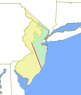
The Lawrence Line was a boundary line or partition line drawn through the Province of New Jersey during the colonial period, dividing it into the Province of West Jersey and the Province of East Jersey. The line was created by surveyor John Lawrence in 1743, and sought to offer final resolution to the division between the two proprietary colonies set out on the Quintipartite Deed (1676) which divided New Jersey by a straight line from "the Northernmost Branch of said Bay or River of De la Ware which is in forty-one Degrees and forty minutes of latitude…unto the most southwardly poynt of the East syde of Little Egge Harbour." Several previous surveys, including the Keith Line (1686), the Coxe–Barclay Line (1688), the Thornton Line (1696) were disputed and drawn too far west. Lawrence was commissioned in 1743 to resolve the long-standing disputes.Snyder, John Parr. ''The Story of New Jersey's Civil Boundaries: 1606–1968''. (Trenton, New Jersey: Bureau of Geology and Top ... [...More Info...] [...Related Items...] OR: [Wikipedia] [Google] [Baidu] |
Province Of New Jersey
The Province of New Jersey was one of the Middle Colonies of Colonial America and became the U.S. state of New Jersey in 1783. The province had originally been settled by Europeans as part of New Netherland but came under English rule after the surrender of Fort Amsterdam in 1664, becoming a proprietary colony. The English renamed the province after the island of Jersey in the English Channel. The Dutch Republic reasserted control for a brief period in 1673–1674. After that it consisted of two political divisions, East Jersey and West Jersey, until they were united as a royal colony in 1702. The original boundaries of the province were slightly larger than the current state, extending into a part of the present state of New York, until the border was finalized in 1773. Background The Province of New Jersey was originally settled in the 1610s as part of the colony of New Netherland. The surrender of Fort Amsterdam in September 1664 gave control over the entire Mid-At ... [...More Info...] [...Related Items...] OR: [Wikipedia] [Google] [Baidu] |
Sandyston Township, New Jersey
Sandyston Township is a small rural township in Sussex County, New Jersey. It is located in the northwestern part of the state near the Pennsylvania border. The township is surrounded by and part of many national and state parks. As of the 2010 United States census, the township's population was 1,998, reflecting an increase of 173 (+9.5%) from the 1,825 counted in the 2000 census, which had in turn increased by 93 (+5.4%) from the 1,732 counted in the 1990 census. Sandyston's growth in recent years has been attributed to the influx of people from more urban parts of the state and even New York City, located less than away. ''New Jersey Monthly'' magazine ranked Sandyston Township 26th on its 2008 rankings of the "Best Places To Live" in New Jersey. Sandyston was first formed by royal charter on February 26, 1762, from portions of Walpack Township. Sandyston was incorporated as a township on February 21, 1798, by an act of the New Jersey Legislature as part of the initial g ... [...More Info...] [...Related Items...] OR: [Wikipedia] [Google] [Baidu] |
History Of The Thirteen Colonies
The Thirteen Colonies, also known as the Thirteen British Colonies, the Thirteen American Colonies, or later as the United Colonies, were a group of British colonies on the Atlantic coast of North America. Founded in the 17th and 18th centuries, they began fighting the American Revolutionary War in April 1775 and formed the United States of America by declaring full independence in July 1776. Just prior to declaring independence, the Thirteen Colonies in their traditional groupings were: New England (New Hampshire; Massachusetts; Rhode Island; Connecticut); Middle ( New York; New Jersey; Pennsylvania; Delaware); Southern (Maryland; Virginia; North Carolina; South Carolina; and Georgia). The Thirteen Colonies came to have very similar political, constitutional, and legal systems, dominated by Protestant English-speakers. The first of these colonies was Virginia Colony in 1607, a Southern colony. While all these colonies needed to become economically viable, the founding of t ... [...More Info...] [...Related Items...] OR: [Wikipedia] [Google] [Baidu] |
Global Positioning System
The Global Positioning System (GPS), originally Navstar GPS, is a satellite-based radionavigation system owned by the United States government and operated by the United States Space Force. It is one of the global navigation satellite systems (GNSS) that provides geolocation and time information to a GPS receiver anywhere on or near the Earth where there is an unobstructed line of sight to four or more GPS satellites. It does not require the user to transmit any data, and operates independently of any telephonic or Internet reception, though these technologies can enhance the usefulness of the GPS positioning information. It provides critical positioning capabilities to military, civil, and commercial users around the world. Although the United States government created, controls and maintains the GPS system, it is freely accessible to anyone with a GPS receiver. The GPS project was started by the U.S. Department of Defense in 1973. The first prototype spacecraft was lau ... [...More Info...] [...Related Items...] OR: [Wikipedia] [Google] [Baidu] |
Sussex County, New Jersey
Sussex County is the northernmost county in the State of New Jersey. Its county seat is Newton.New Jersey County Map New Jersey Department of State. Accessed July 10, 2017. It is part of the New York metropolitan area and is part of New Jersey's . As of the , the county's populatio ... [...More Info...] [...Related Items...] OR: [Wikipedia] [Google] [Baidu] |
Green Township, New Jersey
Green Township is a Township (New Jersey), township in Sussex County, New Jersey, Sussex County, New Jersey, United States. As of the 2010 United States Census, the township's population was 3,601, reflecting an increase of 381 (+11.8%) from the 3,220 counted in the 2000 United States Census, 2000 Census, which had in turn increased by 511 (+18.9%) from the 2,709 counted in the 1990 United States Census, 1990 Census. History On November 20, 1824, the southern portion of Sussex County was set off to create Warren County, New Jersey, Warren County. The northern portions of both Hardwick Township, New Jersey, Hardwick and Independence Township, New Jersey, Independence Townships, remained in Sussex County and were incorporated as Green Township by an act of the New Jersey Legislature on December 27, 1824.Snyder, John P''The Story of New Jersey's Civil Boundaries: 1606-1968'' Bureau of Geology and Topography; Trenton, New Jersey; 1969. p. 230. Accessed August 30, 2012. In 1829, p ... [...More Info...] [...Related Items...] OR: [Wikipedia] [Google] [Baidu] |
Hampton Township, New Jersey
Hampton Township is a township in Sussex County, in the U.S. state of New Jersey. As of the 2020 United States census, the township's population was 4,893, a decline of 303 (-5.8%) from the 2010 census count of 5,196, which had in turn increased by 253 (+5.1%) from the 4,943 counted in the 2000 census. The township passed an ordinance that prohibits short term rentals below 150 days as of May 2021, this specifically targets people benefitting from using companies such as Airbnb. Hampton Township was formed from portions of Sussex County by an act of the New Jersey Legislature on April 11, 1864.Snyder, John P''The Story of New Jersey's Civil Boundaries: 1606-1968'' Bureau of Geology and Topography; Trenton, New Jersey; 1969. p. 230. Accessed February 20, 2013. The township was named for Jonathan Hampton, who donated land in 1769 to the Episcopal Church of Newton. State legislator Robert Hamilton, an Episcopalian, appreciated Hampton's generosity, and gave the township its ... [...More Info...] [...Related Items...] OR: [Wikipedia] [Google] [Baidu] |
Stillwater Township, New Jersey
Stillwater Township is a Township (New Jersey), township located in Sussex County, New Jersey, Sussex County, New Jersey, United States. Located in the Kittatinny Valley, Stillwater is a rural farming community with a long history of dairy farming. As of the 2010 United States Census, the township's population was 4,099, reflecting a decrease of 168 (−3.9%) from the 4,267 counted in the 2000 United States Census, 2000 Census, which had in turn increased by 14 (+0.3%) from the 4,253 counted in the 1990 United States Census, 1990 Census. Stillwater was settled in the eighteenth century by German Palatines, Palatine German immigrants who entered through the port of Philadelphia. In 1741, Casper Shafer, John George Wintermute (Windemuth), and their father-in-law Johan Peter Bernhardt settled along the Paulins Kill.Schaeffer, Casper and Johnson, William M. ''Memoirs and reminiscences: together with sketches of the early history of Sussex County, New Jersey''. (Hackensack, N.J. : Pr ... [...More Info...] [...Related Items...] OR: [Wikipedia] [Google] [Baidu] |
Walpack Township, New Jersey
Walpack Township is a township in Sussex County, New Jersey, United States. As of the 2020 United States Census, the township had a population of 7, reflecting a decline of 34 (−82.9%) from the 41 counted in the 2000 Census, which had in turn declined by 26 (−38.8%) from the 67 counted in the 1990 Census. Walpack Township was one of only four municipalities in New Jersey with a double-digit population as of the 2010 Census, and it placed third behind Tavistock (population 5) and Pine Valley (population 12), both in Camden County.New Jersey: 2010 - Population and Housing Unit Counts - 2010 Census of Population and Housing (CPH-2-32) |
West Jersey
West Jersey and East Jersey were two distinct parts of the Province of New Jersey. The political division existed for 28 years, between 1674 and 1702. Determination of an exact location for a border between West Jersey and East Jersey was often a matter of dispute. Background The Delaware Valley had been inhabited by the Lenape (or Delaware) Indians prior to European exploration and settlement starting around 1609, undertaken by the Dutch, Swedish and English. The Dutch West India Company had established one or two Delaware River settlements, but by the late 1620s, it had moved most of its inhabitants to the island of Manhattan. This became the center of New Netherland. West Jersey and East Jersey were two sections of New Jersey. The development of the colony of New Sweden in the lower Delaware Valley began in 1638. Most of the Swedish population was on the west side of the Delaware. After the English re-established New Netherland's Fort Nassau to challenge the Swedes, the ... [...More Info...] [...Related Items...] OR: [Wikipedia] [Google] [Baidu] |
New Jersey Supreme Court
The Supreme Court of New Jersey is the highest court in the U.S. state of New Jersey. In its current form, the Supreme Court of New Jersey is the final judicial authority on all cases in the state court system, including cases challenging the validity of state laws under the state constitution. It has the sole authority to prescribe and amend court rules and regulate the practice of law, and it is the arbiter and overseer of the decennial legislative redistricting. One of its former members, William J. Brennan Jr., became an Associate Justice of the Supreme Court of the United States. It has existed in three different forms under the three different state constitutions since the independence of the state in 1776. As currently constituted, the court replaced the prior New Jersey Court of Errors and Appeals, which had been the highest court created under the Constitution of 1844.Jeffrey S. Mandel, New Jersey Appellate Practice (Gann Law Books), chapter 12:1-1 Now, the Supr ... [...More Info...] [...Related Items...] OR: [Wikipedia] [Google] [Baidu] |
.png)


