|
Land Mine Contamination In Bosnia And Herzegovina
Land mine contamination in Bosnia and Herzegovina is a serious aftereffect of the Bosnian War, which took place from 1992 until 1995. During this time period, all 3 conflicting factions (ARBiH, HVO, and VRS) planted land mines near the current-day political entity borders. As a result, the country has had the most severe land mine problems in the world. Land mine situation Bosnia and Herzegovina's land mine contamination stems exclusively from the 1992–95 war in the country. By 1996, some two million land mines and unexploded munitions littered Bosnia. By September 2013, land mines and unexploded munitions remained scattered in 28,699 locations. A total of 1,230.70 km2 (2.4% of the country's territory) was mined. In May 2014, extensive landslides and the worst flooding since the 19th century unearthed landmines, prompting authorities to send in de-mining workers to locate and deactivate mines that were threatening residential areas. Land mine clearing is done by vario ... [...More Info...] [...Related Items...] OR: [Wikipedia] [Google] [Baidu] |
Landmine Warning Sign In BiH
A land mine is an explosive weapon, explosive device concealed under or on the ground and designed to destroy or disable enemy targets, ranging from combatants to vehicles and tanks, as they pass over or near it. Such a device is typically detonated automatically by way of pressure when a target steps on it or drives over it, although other detonation mechanisms are also sometimes used. A land mine may cause damage by direct blast effect, by fragments that are thrown by the blast, or by both. Landmines are typically laid throughout an area, creating a ''minefield'' which is dangerous to cross. The use of land mines is controversial because of their potential as indiscriminate weapons. They can remain dangerous many years after a conflict has ended, harming civilians and the economy. Seventy-eight countries are contaminated with land mines and 15,000–20,000 people are killed every year while many more are injured. Approximately 80% of land mine casualties are civilians, with ... [...More Info...] [...Related Items...] OR: [Wikipedia] [Google] [Baidu] |
Tuzla Canton
The Tuzla Canton ( bs, Tuzlanski kanton; hr, Tuzlanska županija; sr, Тузлански кантон) is one of 10 cantons of the Federation of Bosnia and Herzegovina, one of two entities in Bosnia and Herzegovina. The cantonal seat is the city of Tuzla. Municipalities The Tuzla Canton comprises the following municipalities: History and culture The canton was created by the Washington Agreement in 1994, and its boundaries defined by the Dayton Agreement in 1995. Tuzla Canton was called Tuzla-Podrinje Canton until February 1999. Podrinje means ‘region near the river Drina’ but as the river did not flow through the Canton, a name change was authorised. The Srebrenik Fortress is Bosnia's best-preserved medieval fort, dating from 1333 and is located in Srebrenik. The Panonian lake is a famous holiday resort for tourists. Tuzla is the hip hop center of the Balkans due to Edo Maajka, Frenkie and the first hip hop station in Bosnia, which is located in Tuzla, FMJAM. Music a ... [...More Info...] [...Related Items...] OR: [Wikipedia] [Google] [Baidu] |
Republika Srpska
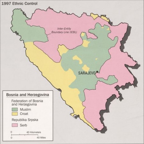
Republika Srpska ( sr-Cyrl, Република Српска, lit=Serb Republic, also known as Republic of Srpska, ) is one of the two Political divisions of Bosnia and Herzegovina, entities of Bosnia and Herzegovina, the other being the Federation of Bosnia and Herzegovina. It is located in the north and east of the country. Its largest city and administrative centre is Banja Luka, lying on the Vrbas (river), Vrbas river. Republika Srpska was formed in 1992 at the outset of the Bosnian War with the stated intent to safeguard the interests of the Serbs of Bosnia and Herzegovina. The war saw the Ethnic cleansing in the Bosnian War, expulsion of the vast majority of Croats of Bosnia and Herzegovina, Croats and Bosniaks from the territory claimed by Republika Srpska and an inflow of Serbs expelled from Federation of Bosnia and Herzegovina. Following the Dayton Agreement of 1995, Republika Srpska achieved international recognition as an entity within Bosnia and Herzegovina. ... [...More Info...] [...Related Items...] OR: [Wikipedia] [Google] [Baidu] |
Brčko District
Brčko District ( bs, Brčko Distrikt; hr, Brčko Distrikt; sr, Брчко Дистрикт, ), officially the Brčko District of Bosnia and Herzegovina ( bs, Brčko Distrikt Bosne i Hercegovine; hr, Brčko Distrikt Bosne i Hercegovine; ), is the self-governing administrative unit in north-eastern Bosnia and Herzegovina. Officially a condominium of the Federation of Bosnia and Herzegovina and Republika Srpska, it was formed in 1999 to reflect the multi-ethnic nature of Brčko and the surrounding areas and their special status within the newly independent Bosnia. In reality, it functions as a local self-government area, much like the other municipalities in the country. The seat of the district is the city of Brčko. History The Brčko District was established after an arbitration process undertaken by the High Representative for Bosnia and Herzegovina. According to the Dayton Peace Accords, however, the process could only arbitrate the disputed portion of the Inter-Entity ... [...More Info...] [...Related Items...] OR: [Wikipedia] [Google] [Baidu] |
Federation Of Bosnia And Herzegovina
The Federation of Bosnia and Herzegovina is one of the two Political divisions of Bosnia and Herzegovina, entities within the State of Bosnia and Herzegovina, the other being Republika Srpska. The Federation of Bosnia and Herzegovina consists of 10 autonomous Cantons of the Federation of Bosnia and Herzegovina, cantons with their own governments and legislatures. The Federation was created by the 1994 Washington Agreement (1994), Washington Agreement, which ended the Croat–Bosniak War within the Bosnian War, and established a constituent assembly that continued its work until October 1996. The Federation has a Sarajevo, capital, Government of Bosnia and Herzegovina, government, president, parliament, customs and police departments and two postal systems. It occupies about half of the land of Bosnia and Herzegovina. From 1996 until 2005 it had its own army, the Army of the Federation of Bosnia and Herzegovina, later merged in the Armed Forces of Bosnia and Herzegovina. The ca ... [...More Info...] [...Related Items...] OR: [Wikipedia] [Google] [Baidu] |
Canton 10
Canton 10 ( hr, Hercegbosanska županija; bs, Kanton 10; sr-cyrl, Кантон 10) or Herzeg-Bosnian canton is the largest of the cantons of the Federation of Bosnia and Herzegovina by area and eighth by population. It mainly covers an area of the historical and geographical region of Tropolje. The local government seat is in Livno, while the assembly is in Tomislavgrad. Name, symbols and language In Croatian, the term '' županija'' is used, while in Bosnian and Serbian the term is ''kanton''/кантон. The canton is officially referred by the Federation of Bosnia and Herzegovina as Canton 10 (''Kanton 10'' or ''Županija 10''). The local government refers to it as the Herzeg-Bosnia County, in Croatian ''Hercegbosanska županija'', and uses that name in the local constitution. This name was declared unconstitutional by the Constitutional Court of the Federation because "neither part of the territory of the canton belongs to Herzegovina as a region". Other names used ... [...More Info...] [...Related Items...] OR: [Wikipedia] [Google] [Baidu] |
Sarajevo Canton
The Sarajevo Canton, officially the Canton of Sarajevo ( bs, Kanton Sarajevo; hr, Sarajevska županija; sr-Cyrl, Сарајевски кантон), is one of 10 cantons of the Federation of Bosnia and Herzegovina in Bosnia and Herzegovina. Its cantonal seat is the city of Sarajevo, also the capital city of Bosnia and Herzegovina. The Canton represents the metro area of the country's capital city, Sarajevo, together with the City of East Sarajevo. It contains 97% of the city's population, but a much smaller percentage of the official land area. The majority of the population is Bosniak (83,8%). History The history of Sarajevo dates back to Neolithic times, when the Butmir culture made its mountains and hills their home. In ancient times, the Sarajevo area (Canton) was occupied by the Illyrians. The local tribe, the Daesitates, controlled most of the area. They were a warlike bunch and the last Illyrian tribe to resist Roman rule, which finally came in AD 9. Under Roma ... [...More Info...] [...Related Items...] OR: [Wikipedia] [Google] [Baidu] |
West Herzegovina Canton
The West Herzegovina Canton ( hr, Županija Zapadnohercegovačka, bs, Zapadnohercegovački kanton) is one of the cantons of the Federation of Bosnia and Herzegovina. The West Herzegovina Canton is in the Herzegovina region in the southwest of Bosnia and Herzegovina. Its seat of government is in Široki Brijeg, while other municipalities within the Canton are Grude, Ljubuški and Posušje. It has 94,898 inhabitants, of whom more than 98% are ethnic Croats. History The majority of the present-day West Herzegovina Canton was part of Zachlumia, the medieval South Slavic principality. In the 15th century it became part of the Duchy of Saint Sava under Stjepan Vukčić Kosača, who proclaimed himself the herzog (duke), thus giving the name for the whole region - Herzegovina. The Ottomans conquered Herzegovina in 1483, when the territory of the West Herzegovina Canton became part of the Sanjak of Herzegovina. In 1833 the Sanjak of Herzegovina became more autonomous under Ali-paša R ... [...More Info...] [...Related Items...] OR: [Wikipedia] [Google] [Baidu] |
Herzegovina-Neretva Canton
The Herzegovina-Neretva Canton ( hr, Hercegovačko-neretvanska županija; bs, Hercegovačko-neretvanski kanton) is one of 10 cantons of the Federation of Bosnia and Herzegovina in Bosnia and Herzegovina. The canton mainly comprises the Neretva river valley area and parts of Herzegovina west of Mostar, its administrative center. It is one of the 4 cantons in the country with a Croatian majority (53.29%), although in the case of this territory it is more ethnically divided and is considered to have a mixed population. History Before the war in Bosnia and Herzegovina, the present-day municipalities of East Mostar and Berkovići were part of Mostar and Stolac, while Ivanica was part of the municipality of Trebinje. The history of today's Herzegovina-Neretva Canton begins on March 18, 1994, with the signing of the Washington Agreement. The canton was officially constituted on December 23, 1996 as one of the ten cantons of the Federation of Bosnia and Herzegovina. Geography ... [...More Info...] [...Related Items...] OR: [Wikipedia] [Google] [Baidu] |
Central Bosnia Canton
The Central Bosnia Canton ( bs, Srednjobosanski kanton/Средњобосански кантон, hr, Županija Središnja Bosna) is one of 10 cantons of the Federation of Bosnia and Herzegovina in Bosnia and Herzegovina. The most populous settlement in the region is Bugojno, followed by Travnik and Novi Travnik. Geography It is located in the center of the country, to the west of Sarajevo. The center of canton government is Travnik. Municipalities The canton is split into the municipalities of Bugojno, Busovača, Dobretići, Donji Vakuf, Fojnica, Gornji Vakuf-Uskoplje, Jajce, Kiseljak, Kreševo, Novi Travnik, Travnik, Vitez. The region reports a GDP equitable with the average of Bosnia and Herzegovina more broadly. The region has historically benefitted from agriculture and trade, as well as mineral deposits. The Central Bosnia Canton is the fifth largest of ten and its share of the national population is slightly below average. In April of 2022, the United Nations' Off ... [...More Info...] [...Related Items...] OR: [Wikipedia] [Google] [Baidu] |
Bosnian-Podrinje Canton Goražde
The Bosnian-Podrinje Canton Goražde ( sh-Latn-Cyrl, Bosansko-podrinjski kanton Goražde, Босанско-подрињски кантон Горажде), until 2001 Goražde Canton ( sh-Latn-Cyrl, Goraždansko-podrinjski kanton, Горажданско-подрињски кантон is one of ten cantons of the Federation of Bosnia and Herzegovina, an entity in Bosnia and Herzegovina. Demographics 2013 Census Geography It is located in the south-eastern central part of the country, in the region of Upper Drina. The cantonal seat is in Goražde. Municipalities The canton consists of the municipalities of Goražde, Pale-Prača, Foča-Ustikolina. See also * Drina Banovina * Podrinje * List of heads of the Bosnia-Podrinje Canton Goražde This is a list of heads of the Bosnian-Podrinje Canton Goražde The Bosnian-Podrinje Canton Goražde ( sh-Latn-Cyrl, Bosansko-podrinjski kanton Goražde, Босанско-подрињски кантон Горажде), until 2001 Go ... [...More Info...] [...Related Items...] OR: [Wikipedia] [Google] [Baidu] |
Zenica-Doboj Canton
The Zenica-Doboj Canton (; hr, Zeničko-dobojska županija; sr, Зеничко-добојски кантон) is one of 10 cantons of the Federation of Bosnia and Herzegovina in Bosnia and Herzegovina. The cantonal seat is the City of Zenica. History During the protests and riots in Bosnia and Herzegovina in February 2014, the entire government of the Zenica-Doboj Canton resigned. Geography This canton is situated in the central part of Bosnia and Herzegovina. The cantonal capital is Zenica and the other town mentioned in the name is Doboj, which is in Republika Srpska, but part of the former Doboj municipality is in the Zenica-Doboj Canton. The canton has an area of 3,904 km2. Municipalities The Zenica-Doboj Canton is split into the following municipalities: Demographics 2013 Census As of 2013 census, a total of 364,433 inhabitants lives in Zenica-Doboj Canton. See also * Political divisions of Bosnia and Herzegovina * List of heads of the Zenica-Doboj Canton * ... [...More Info...] [...Related Items...] OR: [Wikipedia] [Google] [Baidu] |


