|
Lakeview Historic District (Chicago, Illinois)
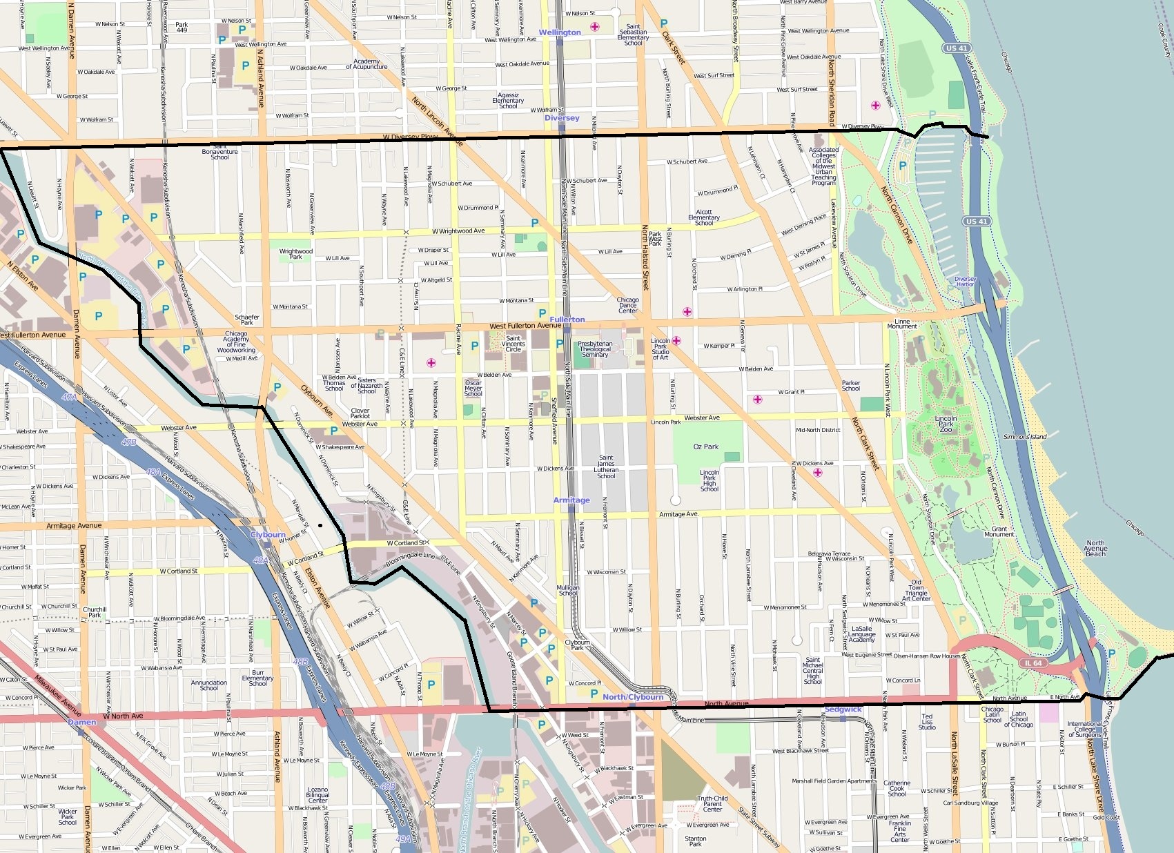
The Lakeview Historic District is a historic district (United States), historic district on the north side of the city of Chicago, Illinois. The district was listed on the U.S. National Register of Historic Places on September 15, 1977. The district, which is in southeastern Lakeview Township about north of the Chicago Loop, is primarily in the Lake View, Chicago, Lake View community but also includes a small part of the Lincoln Park, Chicago, Lincoln Park neighborhood to the south. A boundary expansion on May 16, 1986, added a one-block section on the south side of Belmont Avenue (Chicago), Belmont Avenue, between Orchard and Halsted Streets. Land use in the historic district is primarily multi-family residential. Streets are laid out on a rectangular grid that is broken by the short jogs in some of the streets and crossed on the diagonal by Clark Street (Chicago), Clark Street. References Historic districts in Chicago North Side, Chicago Chicago Landmarks Building ... [...More Info...] [...Related Items...] OR: [Wikipedia] [Google] [Baidu] |
Historic District (United States)
Historic districts in the United States are designated historic districts recognizing a group of buildings, Property, properties, or sites by one of several entities on different levels as historically or architecturally significant. Buildings, structures, objects and sites within a historic district are normally divided into two categories, Contributing property, contributing and non-contributing. Districts vary greatly in size: some have hundreds of structures, while others have just a few. The U.S. federal government designates historic districts through the United States Department of the Interior, United States Department of Interior under the auspices of the National Park Service. Federally designated historic districts are listed on the National Register of Historic Places, but listing usually imposes no restrictions on what property owners may do with a designated property. U.S. state, State-level historic districts may follow similar criteria (no restrictions) or may req ... [...More Info...] [...Related Items...] OR: [Wikipedia] [Google] [Baidu] |
Chicago, Illinois
(''City in a Garden''); I Will , image_map = , map_caption = Interactive Map of Chicago , coordinates = , coordinates_footnotes = , subdivision_type = Country , subdivision_name = United States , subdivision_type1 = State , subdivision_type2 = Counties , subdivision_name1 = Illinois , subdivision_name2 = Cook and DuPage , established_title = Settled , established_date = , established_title2 = Incorporated (city) , established_date2 = , founder = Jean Baptiste Point du Sable , government_type = Mayor–council , governing_body = Chicago City Council , leader_title = Mayor , leader_name = Lori Lightfoot ( D) , leader_title1 = City Clerk , leader_name1 = Anna Valencia ( D) , unit_pref = Imperial , area_footnotes = , area_tot ... [...More Info...] [...Related Items...] OR: [Wikipedia] [Google] [Baidu] |
National Register Of Historic Places
The National Register of Historic Places (NRHP) is the United States federal government's official list of districts, sites, buildings, structures and objects deemed worthy of preservation for their historical significance or "great artistic value". A property listed in the National Register, or located within a National Register Historic District, may qualify for tax incentives derived from the total value of expenses incurred in preserving the property. The passage of the National Historic Preservation Act (NHPA) in 1966 established the National Register and the process for adding properties to it. Of the more than one and a half million properties on the National Register, 95,000 are listed individually. The remainder are contributing resources within historic districts. For most of its history, the National Register has been administered by the National Park Service (NPS), an agency within the U.S. Department of the Interior. Its goals are to help property owners and inte ... [...More Info...] [...Related Items...] OR: [Wikipedia] [Google] [Baidu] |
Chicago Loop
The Loop, one of Chicago's 77 designated community areas, is the central business district of the city and is the main section of Downtown Chicago. Home to Chicago's commercial core, it is the second largest commercial business district in North America and contains the headquarters and regional offices of several global and national businesses, retail establishments, restaurants, hotels, and theaters, as well as many of Chicago's most famous attractions. It is home to Chicago's City Hall, the seat of Cook County, and numerous offices of other levels of government and consulates of foreign nations. The intersection of State Street and Madison Street, located in the area, is the origin of the address system of Chicago's street grid. Most of Grant Park's 319 acres (1.29 km2) are in the eastern section of the community area. The Loop community area is bounded on the north and west by the Chicago River, on the east by Lake Michigan, and on the south by Roosevelt Road. The ... [...More Info...] [...Related Items...] OR: [Wikipedia] [Google] [Baidu] |
Lake View, Chicago
Lakeview, also spelled Lake View, is one of the 77 community areas of Chicago, Illinois. Lakeview is located in the city's North Side. It is bordered by West Diversey Parkway on the south, West Irving Park Road on the north, North Ravenswood Avenue on the west, and the shore of Lake Michigan on the east. The Uptown community area is to Lakeview's north, Lincoln Square to its northwest, North Center to its west, and Lincoln Park to its south. The 2020 population of Lakeview was 103,050 residents, making it the second largest of the Chicago community areas by population. Lakeview includes smaller neighborhood enclaves: Sheridan Station Corridor, Northhalsted, Southport Corridor, Wrigleyville, and Wrigley Plaza. Boystown, famous for its large LGBT population, which holds a pride parade each June. Wrigleyville is another popular district. It surrounds Wrigley Field, home of the Chicago Cubs. Lakeview is home to the Belmont Theater District showcasing over 30 theaters and live p ... [...More Info...] [...Related Items...] OR: [Wikipedia] [Google] [Baidu] |
Lincoln Park, Chicago
Lincoln Park is a designated community area on the North Side of Chicago, Illinois. Lying to the west of Lincoln Park, Chicago's largest park, it is one of the most affluent neighborhoods in Chicago. History In 1824, the United States Army built a small post near today's Clybourn Avenue and Armitage Avenue (formerly Centre Street). Native American settlements existed along Green Bay Trail, now called Clark Street (named after George Rogers Clark), at the current intersection of Halsted Street and Fullerton Avenue. Before Green Bay Trail became Clark Street, it stretched as far as Green Bay, Wisconsin, including Sheridan Road, and was part of what still is Green Bay Road in Milwaukee County, Wisconsin. In 1836, land from North to Fullerton and from the lake to Halsted was relatively inexpensive, costing $150 per acre ($370 ha) (1836 prices, not adjusted for inflation). Because the area was considered remote, a smallpox hospital and the city cemetery were located in Linc ... [...More Info...] [...Related Items...] OR: [Wikipedia] [Google] [Baidu] |
Belmont Avenue (Chicago)
Belmont Avenue (3200 N) is a major east–west street in Chicago and some suburbs. Belmont starts at the Belmont harbor area and is a central commercial street in Lakeview and, west of the North Branch of the Chicago River, Avondale. Further west, it anchors the Belmont-Central shopping district straddling the Belmont Cragin and Portage Park communities. The road enters western suburbs River Grove and Franklin Park before the main segment ends with other parts of Belmont still going west. Then west of the Cook County line parts of Belmont enter DuPage County, specifically in Bensenville and Addison, ending. Belmont Avenue was the southern border of Riverview Park. The amusement park remained open from 1904 until 1967. The park's property is now home to the Riverview Plaza shopping center, the Belmont District Police Station, and DeVry Institute of Technology. One of the landmarks on Belmont Avenue was the Bally Manufacturing Corporation complex located between Washtenaw ... [...More Info...] [...Related Items...] OR: [Wikipedia] [Google] [Baidu] |
Halsted Street
Halsted Street is a major north-south street in the U.S. city of Chicago, Illinois. Location In Chicago's grid system, Halsted Street marks 800 West, west of State Street, from Grace Street (3800 N) in Lakeview south to the city limits at the Little Calumet River (13000 S) in West Pullman, a length of 168 north-south Chicago blocks. (From Grace north to Lawrence Avenue (4800 N) in Uptown, 800 W is marked by Clarendon Avenue.) Environs North Side In Lakeview Halsted passes through Wrigleyville, as intersecting with Addison Street, it is only two blocks east of Wrigley Field home of the Chicago Cubs. Halsted is then lined with restaurants, bars and gay bars and clubs as one enters Boystown, Chicago's main gay and lesbian community, running as far as Belmont Avenue. This area also contains numerous theaters and comedy clubs. As it continues south past Diversey (2800 N), it goes past DePaul University and through the Lincoln Park area, as a primary thoroughfare through the ... [...More Info...] [...Related Items...] OR: [Wikipedia] [Google] [Baidu] |
Clark Street (Chicago)
Clark Street is a north-south street in Chicago, Illinois that runs close to the shore of Lake Michigan from the northern city boundary with Evanston, to 2200 South in the city street numbering system. At its northern end, Clark Street is at 1800 West; however the street runs diagonally through the Chicago grid for about to North Avenue (1600 N) and then runs at 100 West for the rest of its course south to Cermak Road. It is also seen in Riverdale beyond 127th street across the Calumet River, along with other nearby streets that ended just south of the Loop. The major length of Clark Street runs a total of 98 blocks. History Clark Street is named for George Rogers Clark, an American Revolutionary War soldier who captured much of the Northwest Territory from the Kingdom of Great Britain, British. Within the Chicago Loop Clark Street is one of the original streets laid out by James Thompson in his 1830 plat of Chicago. North of the Loop, from North Avenue, it roughly foll ... [...More Info...] [...Related Items...] OR: [Wikipedia] [Google] [Baidu] |
Historic Districts In Chicago
History (derived ) is the systematic study and the documentation of the human activity. The time period of event before the invention of writing systems is considered prehistory. "History" is an umbrella term comprising past events as well as the memory, discovery, collection, organization, presentation, and interpretation of these events. Historians seek knowledge of the past using historical sources such as written documents, oral accounts, art and material artifacts, and ecological markers. History is not complete and still has debatable mysteries. History is also an academic discipline which uses narrative to describe, examine, question, and analyze past events, and investigate their patterns of cause and effect. Historians often debate which narrative best explains an event, as well as the significance of different causes and effects. Historians also debate the nature of history as an end in itself, as well as its usefulness to give perspective on the problems of the p ... [...More Info...] [...Related Items...] OR: [Wikipedia] [Google] [Baidu] |
North Side, Chicago
{{CatAutoTOC ...
Chicago is the third largest city in the United States with a population of 2,853,114 (2009). It is located in the state of Illinois, on the shores of Lake Michigan. The city is the county seat of Cook County. Geography of Chicago Chicago (''City in a Garden''); I Will , image_map = , map_caption = Interactive Map of Chicago , coordinates = , coordinates_footnotes = , subdivision_type = Country , subdivision_name ... [...More Info...] [...Related Items...] OR: [Wikipedia] [Google] [Baidu] |
Chicago Landmarks
Chicago Landmark is a designation by the Mayor and the City Council of Chicago for historic sites in Chicago, Illinois, United States. Listed sites are selected after meeting a combination of criteria, including historical, economic, architectural, artistic, cultural, and social values. Once a site is designated as a landmark, it is subject to the Chicago Landmarks Ordinance, which requires that any alterations beyond routine maintenance, up to and including demolition, must have their permit reviewed by the Landmarks Commission. Many Chicago Landmarks are also listed on the National Register of Historic Places, providing federal tax support for preservation, and some are further designated National Historic Landmarks, providing additional federal oversight. Criteria The Mayor and the City Council appoint a nine-member Commission on Chicago Landmarks to develop landmark recommendations in accordance with a 1968 Chicago city ordinance. The commission considers areas, dist ... [...More Info...] [...Related Items...] OR: [Wikipedia] [Google] [Baidu] |


.jpg)