|
Lake Qaraoun
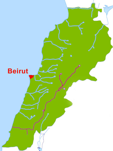
Lake Qaraoun ( ar, بحيرة القرعون / ALA-LC: ''Buḥayrat al-Qara‘ūn'') is an artificial lake or reservoir located in the southern region of the Beqaa Valley, Lebanon. It was created near Qaraoun village in 1959 by building a concrete-faced rockfill dam (the largest dam in Lebanon) in the middle reaches of the Litani River (longest river in Lebanon). The reservoir has been used for hydropower generation (), domestic water supply, and for irrigation of . The annual surface water flow in the Litani River received at Lake Qaraoun is . This flow is used for generating hydroelectric power of 600 GWh at three hydroelectric power stations at Markaba, Awali and Jun with the total installed capacity of . During the dry season, of water is diverted from Markaba power station to meet the needs of the Kassmieh irrigation project. The lake is a habitat for some 20,000 migratory birds which visit it annually. Geography Note 420 million cubic meters is approximately 15 billion c ... [...More Info...] [...Related Items...] OR: [Wikipedia] [Google] [Baidu] |
Beqaa Valley
The Beqaa Valley ( ar, links=no, وادي البقاع, ', Lebanese ), also transliterated as Bekaa, Biqâ, and Becaa and known in classical antiquity as Coele-Syria, is a fertile valley in eastern Lebanon. It is Lebanon's most important farming region. Industry also flourishes in Beqaa, especially that related to agriculture. The Beqaa is located about east of Beirut. The valley is situated between Mount Lebanon to the west and the Anti-Lebanon Mountains to the east. It forms the northeasternmost extension of the Great Rift Valley, which stretches from Syria to the Red Sea. Beqaa Valley is long and wide on average. It has a Mediterranean climate of wet, often snowy winters and dry, warm summers. The region receives limited rainfall, particularly in the north, because Mount Lebanon creates a rain shadow that blocks precipitation coming from the sea. The northern section has an average annual rainfall of , compared to in the central valley. Nevertheless, two rivers ... [...More Info...] [...Related Items...] OR: [Wikipedia] [Google] [Baidu] |
Karstic
Karst is a topography formed from the dissolution of soluble rocks such as limestone, dolomite, and gypsum. It is characterized by underground drainage systems with sinkholes and caves. It has also been documented for more weathering-resistant rocks, such as quartzite, given the right conditions. Subterranean drainage may limit surface water, with few to no rivers or lakes. However, in regions where the dissolved bedrock is covered (perhaps by debris) or confined by one or more superimposed non-soluble rock strata, distinctive karst features may occur only at subsurface levels and can be totally missing above ground. The study of ''paleokarst'' (buried karst in the stratigraphic column) is important in petroleum geology because as much as 50% of the world's hydrocarbon reserves are hosted in carbonate rock, and much of this is found in porous karst systems. Etymology The English word ''karst'' was borrowed from German in the late 19th century, which entered German much earlier. ... [...More Info...] [...Related Items...] OR: [Wikipedia] [Google] [Baidu] |
Larks
Larks are passerine birds of the family Alaudidae. Larks have a cosmopolitan distribution with the largest number of species occurring in Africa. Only a single species, the horned lark, occurs in North America, and only Horsfield's bush lark occurs in Australia. Habitats vary widely, but many species live in dry regions. When the word "lark" is used without specification, it often refers to the Eurasian skylark ''(Alauda arvensis)''. Taxonomy and systematics The family Alaudidae was introduced in 1825 by the Irish zoologist Nicholas Aylward Vigors as a subfamily Alaudina of the finch family Fringillidae. Larks are a well-defined family, partly because of the shape of their . They have multiple scutes on the hind side of their tarsi, rather than the single plate found in most songbirds. They also lack a pessulus, the bony central structure in the syrinx of songbirds. They were long placed at or near the beginning of the songbirds or oscines (now often called Passeri), just af ... [...More Info...] [...Related Items...] OR: [Wikipedia] [Google] [Baidu] |
Nitrate
Nitrate is a polyatomic ion A polyatomic ion, also known as a molecular ion, is a covalent bonded set of two or more atoms, or of a metal complex, that can be considered to behave as a single unit and that has a net charge that is not zero. The term molecule may or may no ... with the chemical formula . salt (chemistry), Salts containing this ion are called nitrates. Nitrates are common components of fertilizers and explosives. Almost all inorganic nitrates are solubility, soluble in water. An example of an insoluble nitrate is bismuth oxynitrate. Structure The ion is the conjugate acid, conjugate base of nitric acid, consisting of one central nitrogen atom surrounded by three identically bonded oxygen atoms in a trigonal planar arrangement. The nitrate ion carries a formal charge of −1. This charge results from a combination formal charge in which each of the three oxygens carries a − charge, whereas the nitrogen carries a +1 charge, all these adding up to formal c ... [...More Info...] [...Related Items...] OR: [Wikipedia] [Google] [Baidu] |
Biochemical Oxygen Demand
Biochemical oxygen demand (BOD) is the amount of dissolved oxygen (DO) needed (i.e. demanded) by aerobic biological organisms to break down organic material present in a given water sample at a certain temperature over a specific time period. The BOD value is most commonly expressed in milligrams of oxygen consumed per litre of sample during 5 days of incubation at 20 °C and is often used as a surrogate of the degree of organic pollution of water. BOD reduction is used as a gauge of the effectiveness of wastewater treatment plants. BOD of wastewater effluents is used to indicate the short-term impact on the oxygen levels of the receiving water. BOD analysis is similar in function to chemical oxygen demand (COD) analysis, in that both measure the amount of organic compounds in water. However, COD analysis is less specific, since it measures everything that can be chemically oxidized, rather than just levels of biologically oxidized organic matter. Background Most natur ... [...More Info...] [...Related Items...] OR: [Wikipedia] [Google] [Baidu] |
Joun
Joun (also Joon, Djoun in Phoenician, ar, جون) is a Lebanese village sitting on seven hills in the Chouf ( ar, قضاء الشوف) district of Mount Lebanon at a distance of 13 kilometers from the city of Sidon in Lebanon. Joun means "the corner" in Aramaic, and it is located in between Mount Lebanon and South Lebanon, forming a corner shape. Joun is a village of approximately 7,400 inhabitants, who are mainly Greek Catholic, Shiite, and Maronite. History Joun is an old village located above the temple of the Phoenician god Eshmun near the city of Sidon. In 1887, the Ottomans appointed the first commission of Joun. The members were: Gerges Chamy, Mitri Mousawbaa, Assaad Khoriaty, Mikhael Nab’aa, Youssef Gebran Khoury (Greek Catholics); Hossein Chamseddine, Hossein Saleh (Shiites); Ibrahim Youness, Youssef Estefan (Maronites); and Youssef Koussa (Protestant). Their tasks were to take care of the land of Joun and regulate the environment and day-to-day work, such as agricul ... [...More Info...] [...Related Items...] OR: [Wikipedia] [Google] [Baidu] |
Ain Ez Zarqa
Ain ez Zarqa (also spelled Ayn ez Zarqa or Ain-el-Zerqa) is a natural artesian karst spring located south of Hermel in the Beqaa Governorate, Lebanon. Producing an average of 3,435 gallons per second, it is the main source of the Orontes River. Because of its heavy flow, it is characterized as a first-magnitude spring. It sits beneath the caves at Deir Mar Maroun, an ancient monastery carved into the cliffs that surround the spring. Melting snow from these nearby heights supplements the spring's large groundwater reservoir, in the Jurassic and Cretaceous strata. It is estimated that the spring's phreatic zone The phreatic zone, saturated zone, or zone of saturation, is the part of an aquifer, below the water table, in which relatively all pores and fractures are saturated with water. Above the water table is the unsaturated or vadose zone The v ... reservoir contains as much as 10 billion cubic metres of storage. As a result, its flow has been less affected by overpumpi ... [...More Info...] [...Related Items...] OR: [Wikipedia] [Google] [Baidu] |
Awali (river)
The Awali ( ar, نهر الأولي / ALA-LC: ''Nahr al-Awalī'', ancient Bostrenus / Bostrenos) is a perennial river flowing in Southern Lebanon. In ancient times it was known as the River Asclepius. It is long, originating from the Barouk mountain at a height of and the Niha mountain. The Awali is supplemented by two tributaries, the Barouk and Aaray rivers. The Awali is also known as the Bisri river in its upper section; it flows through the western face of Mount Lebanon and into the Mediterranean. The Awali river has a discharge of , it forms a watershed that has an area of about . The river flows into Joun Lake, which is part of the Bisri Dam project to improve the supply of fresh water to the region. A large portion of the Bisri Dam project funding, from the World Bank The World Bank is an international financial institution that provides loans and grants to the governments of low- and middle-income countries for the purpose of pursuing capital projects. The Worl ... [...More Info...] [...Related Items...] OR: [Wikipedia] [Google] [Baidu] |
Litani River Authority
{{geodis ...
Litani may refer to: * Litani River (''Nahr al-Līţānī''; from el, Λέοντες Leontes) ** Battle of the Litani River (1941) ** Operation Litani ** Litani offensive * Litani (Maroni) (or ''Itany''), a river forms part of the boundary between Suriname and French Guiana See also * Litany Litany, in Christian worship and some forms of Judaic worship, is a form of prayer used in services and processions, and consisting of a number of petitions. The word comes through Latin ''litania'' from Ancient Greek λιτανεία (''litan ... [...More Info...] [...Related Items...] OR: [Wikipedia] [Google] [Baidu] |
Beqaa Governorate
Beqaa ( ') is a governorate in Lebanon. Districts Since 2014, Beqaa Governorate contains three districts: * West Beqaa * Rashaya * Zahle A law was passed in 2003 to separate Baalbek District and Hermel District from Beqaa Governorate to form a new governorate, Baalbek-Hermel Governorate french: Baalbek-Hermel , settlement_type = Governorate , image_skyline = Baalbek (4594513263).jpg , image_caption = Baalbek , image_flag = , image_seal = , image_shield = , image .... Implementation of Baalbek-Hermel began in 2014 with the appointment of its first governor. Demographics According to voter registration data, the governorate is approximately 41% Christian to 52% Muslim to 7% Druze (313505 voters). In the district (qadaa) of Zahlé (meaning an area much greater than that of the city proper), Christians form a majority of 55% of voters (172555 in total). In the district of West Beqaa-Rashaya (the two are co ... [...More Info...] [...Related Items...] OR: [Wikipedia] [Google] [Baidu] |
Markaba (Beqaa Governorate)
Markaba ( ar, مركبا) is an village located at Marjayoun municipality at Nabatieh Governorate, Lebanon. It is south of Raabatt Tallame, east of Banni Hayyan and northeast of Tallussah, South Lebanon. Name Markaba or Markabah also in Arabic means a vehicle مركبه E. H. Palmer wrote that the name Merkebeh came from a personal name, from "to ride" or "to lie", as one thing on top of another. History In 1596, it was named as a village, ''Markaba famous as Marj Kaba,'' in the Ottoman ''nahiya'' (subdistrict) of Tibnin under the ''liwa''' (district) of Safad, with a population of fifteen households and one bachelor, all Muslim. The villagers paid a fixed tax rate of 25% on agricultural products, such as wheat, barley, fruit trees, goats and beehives, in addition to "occasional revenues"; a total of 5,110 akçe.Hütteroth and Abdulfattah, 1977, p. 182 In 1875 Victor Guérin found Markaba to have 150 Metawileh inhabitants. He further noted: "Here a mosque replaces a mor ... [...More Info...] [...Related Items...] OR: [Wikipedia] [Google] [Baidu] |


.jpg)


_(3231600029).jpg)

.jpg)
