|
Kleiwegkwartier
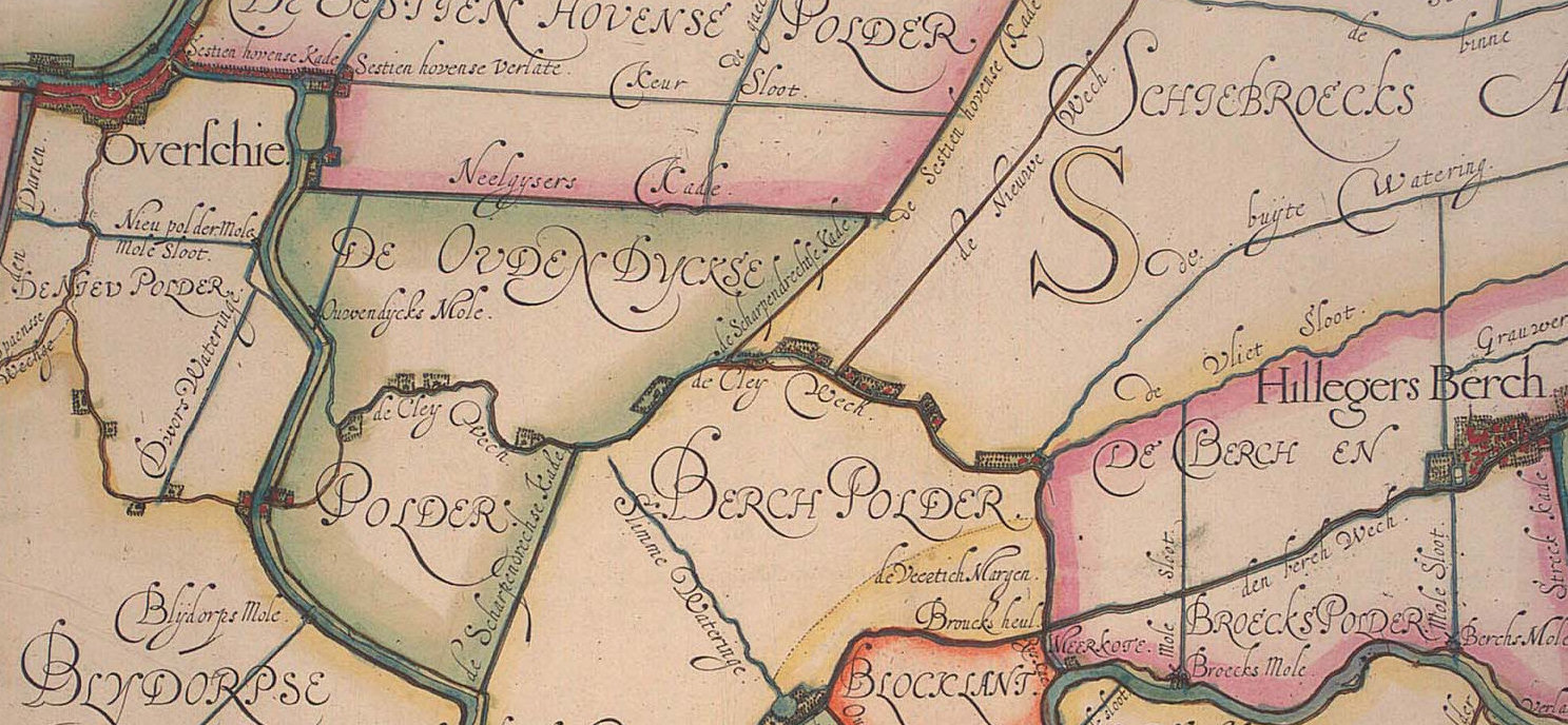
Kleiwegkwartier is a neighbourhood quarter in Rotterdam, Netherlands. It is in the southern part of Hillegersberg with origins dating from the early 1600s. Background The Kleiwegkwartier is located just north of the A20 autoroute and is part of Rotterdam's Hillegersberg-Schiebroek district. The district originally belonged to the municipalities of Hillegersberg and Schiebroek until they were annexed by Rotterdam in 1941. The area now makes part of Rotterdam's Hillegersberg-Zuid district. The area owes its name to the Kleiweg, the main road that runs centrally through its neighbourhood. The Kleiweg originally served as the main connection between Rotterdam and Overschie where it crossed old creek bridges over the Rivers Schie and Rotte. The road's early existence is documented on an area map dated 1611. Over time the road became increasingly lined by farms, houses and businesses—especially with major residential development occurring in the Kleiwegkwartier during the 1930s. ... [...More Info...] [...Related Items...] OR: [Wikipedia] [Google] [Baidu] |
Hillegersberg-Schiebroek
Hillegersberg-Schiebroek is a borough in northern Rotterdam. The borough has (on January 1, 2008) 40,846 inhabitants. Until the annexation by Rotterdam on August 1, 1941, Hillegersberg and Schiebroek were independent communities. In 1947 in Rotterdam, the first elected councils established, in 1948 was the first Hillegersberg-Schiebroek ward council. In 1972, the Regulation on the localities in the city of Rotterdam was adopted. The neighbourhood council of Hillegersberg-Schiebroek was in 1983 converted into a municipal section. Hillegersberg is operated by Rotterdam tram lines 4 and 8 and Schiebroek by tram line 25. The borough is also served by several bus lines from the RET and Qbuzz. Within the municipality Hillegersberg-Schiebroek the Stichting Wijkvervoer Hillegersberg-Schiebroek takes care of cheap transportation for the elderly and other people unable to use own or public transport. This is done under the name De Belbus.http://home.kpn.nl/~f2hbelbus/ Belbus The distri ... [...More Info...] [...Related Items...] OR: [Wikipedia] [Google] [Baidu] |
Hillegersberg
Hillegersberg is a neighbourhood of Rotterdam, Netherlands. Primarily a green residential area with lakes, canals and parks, it was incorporated into the city of Rotterdam in 1941. History Hillegersberg was named after Hildegard van Vlaanderen, wife of Count Dirk II of Holland and West Friesland (920-988). The village was founded on a hill, form by a ridge of sand known locally as a donk or morre. Local flint finds here indicate pre-historic occupation and later discoveries of Roman pottery, medals as well as a bust of Emperor Hadrian show subsequent early activity in the area. According to legend, this ridge was formed by sand dropped from the apron of the mythical giant Hillegonda. She was said to have built her house on this ridge and so Hillegersberg, then known as Hillegonda's mountain, was named. The image of the giant Hillegonda with her torn apron is shown on Hillegersberg's coat of arms. A church and a castle, , were subsequently built on the ridge. The castle w ... [...More Info...] [...Related Items...] OR: [Wikipedia] [Google] [Baidu] |
Provinces Of The Netherlands
There are twelve provinces of the Netherlands (), representing the administrative layer between the national government and the local municipalities, with responsibility for matters of subnational or regional importance. The most populous province is South Holland, with just over 3.7 million inhabitants as of January 2020, and also the most densely populated province with . With 383,488 inhabitants, Zeeland has the smallest population. However Drenthe is the least densely populated province with . In terms of area, Friesland is the largest province with a total area of . If water is excluded, Gelderland is the largest province by land area at . The province of Utrecht is the smallest with a total area of , while Flevoland is the smallest by land area at . In total about 10,000 people were employed by the provincial administrations in 2018. The provinces of the Netherlands are joined in the Association of Provinces of the Netherlands (IPO). This organisation promotes the com ... [...More Info...] [...Related Items...] OR: [Wikipedia] [Google] [Baidu] |
Timeline Of Rotterdam
The following is a timeline of the history of the municipality of Rotterdam, Netherlands. Prior to 19th century * ca. 950 - Settlement at the lower end of the fen stream '' Rotte'' * 1270 - Dam built on Rotte. * 1299 - John I, Count of Holland granted rights to the people of Rotterdam, marking the origin of the town. * 1328 - Latin school established * 1340 - City rights granted by William IV, Count of Holland. * 1350 - Rotterdamse Schie (canal) constructed (approximate date). * 1466 - Erasmus, philosopher and Catholic theologian born. * 1477 - Saint Lawrence Church consecrated. * 1489 - Rotterdam besieged by forces of Frans van Brederode. * 1563 - Fire. * 1572 - Spanish in power. * 1574 - Admiralty of Rotterdam organized. * 1611 - Guild of Saint Luke active (approximate date). * 1622 - Erasmus statue by Hendrick de Keyser erected. * 1626 - Collegium Mechanicum established. * 1632 - Population: 20,000 (approximate). * 1643 - Scottish Presbyterian church built. * 1722 - ... [...More Info...] [...Related Items...] OR: [Wikipedia] [Google] [Baidu] |
Rotterdam The Hague Airport
Rotterdam The Hague Airport (formerly ''Rotterdam Airport'', ''Vliegveld Zestienhoven'' in Dutch language, Dutch), is a minor international airport serving Rotterdam, the Netherlands' second largest city, and The Hague, its administrative and royal capital. It is located north northwest of Rotterdam in South Holland and is the third busiest airport in the Netherlands. The airport handled over 2.1 million passengers in 2019 and features scheduled flights to European metropolitan and leisure destinations. It is also used extensively by general aviation and there are several flying clubs, a skydiving club and a flight training school located at the airport. History Early years After World War II, the Politics of the Netherlands, Dutch government decided that a second national airport was needed in addition to Amsterdam Airport Schiphol, Schiphol. Rotterdam had previously had an airport before the war; Waalhaven airport, but it was heavily damaged in the German bombing of Rotterd ... [...More Info...] [...Related Items...] OR: [Wikipedia] [Google] [Baidu] |
German Bombing Of Rotterdam
Rotterdam was subjected to heavy aerial bombardment by the ''Luftwaffe'' during the German invasion of the Netherlands in World War II. The objective was to support the German troops fighting in the city, break Dutch resistance and force the Dutch army to surrender. Bombing began at the outset of hostilities on 10 May and culminated with the destruction of the entire historic city centre on 14 May, an event sometimes referred to as the Rotterdam Blitz. According to an official list published in 2022 at least 1,150 people were killed (with 711 deaths in the 14 May bombing alone) and 85,000 more were left homeless. The psychological and physical success of the raid, from the German perspective, led the ''Oberkommando der Luftwaffe'' (OKL) to threaten to destroy the city of Utrecht if the Dutch command did not surrender. The Dutch surrendered in the late afternoon of 14 May, signing the capitulation early the next morning. Prelude The strategic location of the Netherlands between ... [...More Info...] [...Related Items...] OR: [Wikipedia] [Google] [Baidu] |
Mixed-use Development
Mixed-use is a kind of urban development, urban design, urban planning and/or a zoning type that blends multiple uses, such as residential, commercial, cultural, institutional, or entertainment, into one space, where those functions are to some degree physically and functionally integrated, and that provides pedestrian connections. Mixed-use development may be applied to a single building, a block or neighborhood, or in zoning policy across an entire city or other administrative unit. These projects may be completed by a private developer, (quasi-) governmental agency, or a combination thereof. A mixed-use development may be a new construction, reuse of an existing building or brownfield site, or a combination. Use in North America vs. Europe Traditionally, human settlements have developed in mixed-use patterns. However, with industrialization, governmental zoning regulations were introduced to separate different functions, such as manufacturing, from residential areas. Public ... [...More Info...] [...Related Items...] OR: [Wikipedia] [Google] [Baidu] |
Rotte (river)
The Rotte is a river in the Rhine-Meuse, Maas-delta in the Netherlands. The Rotte is the eponym of the city of Rotterdam: the city was founded in the 13th century when a dam was built along the river. Etymology The river was originally named Rotta, from ''rot,'' meaning "muddy" and ''aa'' meaning "water," thus "muddy water." Geography It rises in Moerkapelle in the so-called Groene Hart, Green Heart. It used to drain the Zuidplaspolder, Zuidplas lake until it was Land reclamation, reclaimed in 1840. It flows past Bleiswijk and Bergschenhoek; and then the village of Hillegersberg, which was built on a sand dune and was one of the few places in the marsh land that could be permanently settled before the dikes were constructed. In the churchyard there are the ruins of a 13th century castle whose origins probably date back to the Roman Empire. Originally it flowed into the Nieuwe Maas in Rotterdam; however, the lower reach of the river was dammed off and the water now flows to th ... [...More Info...] [...Related Items...] OR: [Wikipedia] [Google] [Baidu] |
Schie
Schie () the name for four waterways in the area of Overschie, South Holland, the Netherlands. There are the Delftse Schie, the Delfshavense Schie, the Rotterdamse Schie and the Schiedamse Schie. The existence of these four streams is the result of medieval rivalry among the cities of Delft, Rotterdam, and Schiedam for toll rights. History The original Schie was a swampy creek in the area of Schiebroek that flowed into the former Merwede at the current town of Overschie. The city of Delft formed along this stream and gave it the name Delf, meaning "dig", indicating that this stream was at least partially dug out. The first excavations may have taken place back in Roman times, when the nearby Corbulo Canal also was dug. In 1150, the Schielands High Seawall was built along the Merwede. When the outlying floodplains were made into polders afterwards, the Schie was extended southward and a dam was built at the new mouth. The settlement that formed there was named Schiedam, and be ... [...More Info...] [...Related Items...] OR: [Wikipedia] [Google] [Baidu] |
Overschie
Overschie is a neighborhood of Rotterdam, Netherlands, formerly a separate village with its own municipality. The village of Overschie was located on the intersection of four rivers called "Schie": the Delftsche Schie, Schiedamsche Schie, Delfshavensche Schie, and Rotterdamsche Schie. It was a separate municipality between 1817 and 1941, when it merged with Rotterdam. Immediately after the Second World War, the construction of a large suburb was begun southeast of the village. "Overschie" is now also the name of a ''deelgemeente'' (borough) of the city of Rotterdam, covering the former village, the neighborhood Overschie, Zestienhoven (which also holds the Rotterdam The Hague Airport Rotterdam The Hague Airport (formerly ''Rotterdam Airport'', ''Vliegveld Zestienhoven'' in Dutch), is a minor international airport serving Rotterdam, the Netherlands' second largest city, and The Hague, its administrative and royal capital. I ...), and the countryside to the north including ... [...More Info...] [...Related Items...] OR: [Wikipedia] [Google] [Baidu] |


.jpg)

.jpg)
