|
Kiro
Kiro was a colonial post in what is now the Central Equatoria province of South Sudan on the west side of the Bahr al Jebel or White Nile river. It was in part of the Lado enclave. In 1900 there were said to be 1,500 troops from the Congo Free State divided among the three Lado enclave Nile stations of Kiro, Lado and Redjaf. After the final defeat of the Khalifa by the British under General Herbert Kitchener in 1898, the Nile up to the Uganda border became part of the Anglo-Egyptian Sudan. An expedition upriver from Ondurman arrived in December 1900. A post was established at Kiro, but later was transferred to Mongalla in April 1901 since Kiro was claimed to be in Belgian territory. Edward Fothergill visited the Sudan around this time, basing himself at Mongalla, which lay between Lado to the south and Kiro to the north, but on the east shore of the river. By his account "Kiro, the most northern station of the Congo on the Nile, is very pretty and clean. Lado, the second ... [...More Info...] [...Related Items...] OR: [Wikipedia] [Google] [Baidu] |
Mongalla, South Sudan
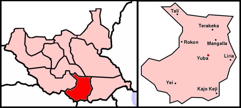
Mongalla or Mangalla is a Payam in Juba County, Central Equatoria State in South Sudan, on the east side of the Bahr al Jebel or White Nile river. It lies about 75 km by road northeast of Juba. The towns of Terekeka and Bor lie downstream, north of Mongalla. During the colonial era, Mongalla was capital of Mongalla Province, which reached south to Uganda and east towards Ethiopia. On 7 December 1917 the last of the northern Sudanese troops were withdrawn from Mongalla, replaced by Equatorial troops. These southern and at least nominally Christian troops remained the only permanent garrison of the town and province until their mutiny in August 1955. Mongalla and the surrounding province was then absorbed into Equatoria Province in 1956. The town was taken and retaken more than once during the Second Sudanese Civil War (1983–2005). An experimental station was established to grow sugar at Mongalla in the 1950s, and there were plans to establish commercial operations. Howe ... [...More Info...] [...Related Items...] OR: [Wikipedia] [Google] [Baidu] |
States Of South Sudan
The States of South Sudan were created out of the three historic former provinces (and contemporary regions) of Bahr el Ghazal (region of South Sudan), Bahr el Ghazal (northwest), Equatoria (southern), and Greater Upper Nile (northeast). The states are further divided into Counties of Southern Sudan, 79 counties. In October 2015, South Sudan's President Salva Kiir Mayardit issued a decree establishing 28 states in place of the 10 that was previously established . The decree established the new states largely along ethnic lines. A number of opposition parties challenged the constitutionality of this decree and the decree was referred to parliament for approval as a constitutional amendment. In November, the South Sudanese parliament approved the creation of the new states. In January 2017, President Salva Kiir stated a decreed of further subdivision of the country from 28 into 32 states. In February 2020, as a result of a peace agreement that ended the South Sudanese Civil War ... [...More Info...] [...Related Items...] OR: [Wikipedia] [Google] [Baidu] |
Central Equatoria
Central Equatoria is a state in South Sudan. With an area of , it is the smallest of the original South Sudanese states. Its previous name was Bahr al-Jabal (also Bahr-el-Jebel), named after a tributary of the White Nile that flows through the state. It was renamed Central Equatoria in the first Interim Legislative Assembly on 1 April 2005 under the government of Southern Sudan. Central Equatoria seceded from Sudan as part of the Republic of South Sudan on 9 July 2011. The state's capital, Juba, is also the national capital of South Sudan. On October 2, 2015, the state was split into three states: Jubek, Terekeka, and Yei River. The state of Central Equatoria was re-established by a peace agreement signed on 22 February 2020. Administrative divisions Central Equatoria, like other states in South Sudan, is subdivided into counties, which are further divided into Payams, then Bomas. Each county is led by a County Commissioner, appointed by the State Governor in consultation wi ... [...More Info...] [...Related Items...] OR: [Wikipedia] [Google] [Baidu] |
East Africa Time
East Africa Time, or EAT, is a time zone used in eastern Africa. The time zone is three hours ahead of UTC ( UTC+03:00), which is the same as Moscow Time, Arabia Standard Time, Further-eastern European Time and Eastern European Summer Time. As this time zone is predominantly in the equatorial region, there is no significant change in day length throughout the year and so daylight saving time is not observed. East Africa Time is observed by the following countries: * * * * * * * * * See also *Moscow Time, an equivalent time zone covering Belarus, Turkey and most of European Russia, also at UTC+03:00 *Arabia Standard Time, an equivalent time zone covering Bahrain, Iraq, Kuwait, Qatar, Saudi Arabia and Yemen, also at UTC+03:00 *Eastern European Summer Time, an equivalent time zone covering European and Middle Eastern countries during daylight saving, also at UTC+03:00 *Israel Summer Time, an equivalent time zone covering the State of Israel during daylight saving, also at U ... [...More Info...] [...Related Items...] OR: [Wikipedia] [Google] [Baidu] |
South Sudan
South Sudan (; din, Paguot Thudän), officially the Republic of South Sudan ( din, Paankɔc Cuëny Thudän), is a landlocked country in East Africa. It is bordered by Ethiopia, Sudan, Central African Republic, Democratic Republic of the Congo, Uganda and Kenya. Its population was estimated as 12,778,250 in 2019. Juba is the capital and largest city. It gained independence from Sudan on 9 July 2011, making it the most recent sovereign state or country with widespread recognition as of 2022. It includes the vast swamp region of the Sudd, formed by the White Nile and known locally as the '' Bahr al Jabal'', meaning "Mountain River". Sudan was occupied by Egypt under the Muhammad Ali dynasty and was governed as an Anglo-Egyptian condominium until Sudanese independence in 1956. Following the First Sudanese Civil War, the Southern Sudan Autonomous Region was formed in 1972 and lasted until 1983. A second Sudanese civil war soon broke out in 1983 and ended in 2005 with the ... [...More Info...] [...Related Items...] OR: [Wikipedia] [Google] [Baidu] |
Herbert Kitchener, 1st Earl Kitchener
Horatio Herbert Kitchener, 1st Earl Kitchener, (; 24 June 1850 – 5 June 1916) was a senior British Army officer and colonial administrator. Kitchener came to prominence for his imperial campaigns, his scorched earth policy against the Boers, his expansion of Lord Roberts' concentration camps during the Second Boer War and his central role in the early part of the First World War. Kitchener was credited in 1898 for having won the Battle of Omdurman and securing control of the Sudan for which he was made Baron Kitchener of Khartoum. As Chief of Staff (1900–1902) in the Second Boer War he played a key role in Roberts' conquest of the Boer Republics, then succeeded Roberts as commander-in-chief – by which time Boer forces had taken to guerrilla fighting and British forces imprisoned Boer civilians in concentration camps. His term as Commander-in-Chief (1902–1909) of the Army in India saw him quarrel with another eminent proconsul, the Viceroy Lord Curzon, who eventu ... [...More Info...] [...Related Items...] OR: [Wikipedia] [Google] [Baidu] |
Uganda
}), is a landlocked country in East Africa East Africa, Eastern Africa, or East of Africa, is the eastern subregion of the African continent. In the United Nations Statistics Division scheme of geographic regions, 10-11-(16*) territories make up Eastern Africa: Due to the historical .... The country is bordered to the east by Kenya, to the north by South Sudan, to the west by the Democratic Republic of the Congo, to the south-west by Rwanda, and to the south by Tanzania. The southern part of the country includes a substantial portion of Lake Victoria, shared with Kenya and Tanzania. Uganda is in the African Great Lakes region. Uganda also lies within the Nile, Nile basin and has a varied but generally a modified equatorial climate. It has a population of around 49 million, of which 8.5 million live in the Capital city, capital and largest city of Kampala. Uganda is named after the Buganda kingdom, which encompasses a large portion of the south of the country, includi ... [...More Info...] [...Related Items...] OR: [Wikipedia] [Google] [Baidu] |
Anglo-Egyptian Sudan
Anglo-Egyptian Sudan ( ar, السودان الإنجليزي المصري ') was a condominium of the United Kingdom and Egypt in the Sudans region of northern Africa between 1899 and 1956, corresponding mostly to the territory of present-day Sudan and South Sudan. Legally, sovereignty and administration were shared between both Egypt and the United Kingdom, but in practice the structure of the condominium ensured effective British control over Sudan, with Egypt having limited, local power influence in reality. In the mean time, Egypt itself fell under increasing British influence. Following the Egyptian Revolution of 1952, Egypt pushed for an end to the condominium, and the independence of Sudan. By agreement between Egypt and the United Kingdom in 1953, Sudan was granted independence as the Republic of the Sudan on 1 January 1956. In 2011, the south of Sudan itself became independent as the Republic of South Sudan. In the 19th century, whilst nominally a vassal state of the ... [...More Info...] [...Related Items...] OR: [Wikipedia] [Google] [Baidu] |


