|
Kilnamadoo
Kilnamadoo () is a townland in County Fermanagh, Northern Ireland. It is situated within the civil parish of the area of Boho, as well as Fermanagh and Omagh district. The Coal Bog road travels through this townland and the adjacent townland of Drumacoorin. This is a traditional peat cutting area and in past times was the main highway between Lough MacNean and Lough Erne. The area is particularly notable for the remnants of a Neolithic settlement found in the coal bog. An impressive bronze spearhead was also found in this area and is now on display in the National Museum of Ireland. Neolithic site On 25 May 1880, a local person known as Mr Bothwell was cutting his turf when he unearthed the ancient site. He immediately sent for the archæologist Thomas Plunkett, who identified the remains as being a Neolithic settlement, situated on what was once an island or crannog in the midst of a body of water. The dimensions of the crannog were long and wide. The settlement contained t ... [...More Info...] [...Related Items...] OR: [Wikipedia] [Google] [Baidu] |
List Of Townlands In County Fermanagh
In Ireland, counties are divided into civil parishes, and parishes are further divided into townlands. The following is a list of townlands in County Fermanagh, Northern Ireland: __NOTOC__ A Abocurragh, Abohill, Acres, Aghaboy, Aghacramphill, Aghaderryloman, Aghadreenan Glebe, Aghadrum, Aghadrumsee and Killygorman, Aghagaffert, Aghagay, Aghagrefin, Aghahannagh, Aghaherrish, Aghahoorin, Aghakeeran, Aghakillymaude, Aghalaan, Aghalane, Aghalun, Aghalurcher Glebe, Aghaleague, Aghama, Aghameelan, Aghamore, Aghamore North, Aghamore South, Aghamuldowney, Aghanaglack, Aghanaglogh, Aghannagh, Agharahan, Agharainy, Agharoosky, Agharoosky East, Agharoosky West, Aghatirourke, Aghavea Glebe, Aghavoory, Aghavore, Aghaweenagh, Agheeghter, Aghindaiagh, Aghindisert, Aghinish Island, Aghintra, Aghinure, Aghinver, Aghnablaney, Aghnacarra, Aghnachuill, Aghnacloy, Aghnacloy North, Aghnacloy South, Aghnagrane, Aghnahinch, Aghnahoo, Aghnaloo, Aghnash ... [...More Info...] [...Related Items...] OR: [Wikipedia] [Google] [Baidu] |
Boho, County Fermanagh
Boho (pronounced , ) is a hamlet and a civil parish covering approximately southwest of Enniskillen in County Fermanagh, Northern Ireland. It is situated within Fermanagh and Omagh district. This area contains a high density of historically significant sites stretching from the Neolithic Reyfad Stones, through the Bronze Age/Iron Age (Aghnaglack Tomb) and medieval (High Crosses) to comparatively recent historical buildings such as the Linnett Inn. Boho parish has a high biodiversity of flora and fauna due in part to the niches offered by the limestone karst substrata combined with fen meadow, upland heath and acidic bog. The three mountains found within the parish; namely Glenkeel, Knockmore and Belmore provide a landscape varying from high craggy bluffs, with views of neighbouring counties, to low, flat bogland punctuated by streams and lakes. Below this landscape are two of the three most cave-rich mountains in Northern Ireland, featuring the deepest cave system in Irelan ... [...More Info...] [...Related Items...] OR: [Wikipedia] [Google] [Baidu] |
County Fermanagh
County Fermanagh ( ; ) is one of the thirty-two counties of Ireland, one of the nine counties of Ulster and one of the six counties of Northern Ireland. The county covers an area of 1,691 km2 (653 sq mi) and has a population of 61,805 as of 2011. Enniskillen is the county town and largest in both size and population. Fermanagh is one of four counties of Northern Ireland to have a majority of its population from a Catholic background, according to the 2011 census. Geography Fermanagh is situated in the southwest corner of Northern Ireland. It spans an area of 1,851 km2 (715 sq; mi), accounting for 13.2% of the landmass of Northern Ireland. Nearly a third of the county is covered by lakes and waterways, including Upper and Lower Lough Erne and the River Erne. Forests cover 14% of the landmass (42,000 hectares). It is the only county in Northern Ireland that does not border Lough Neagh. The county has three prominent upland areas: * the expansive We ... [...More Info...] [...Related Items...] OR: [Wikipedia] [Google] [Baidu] |
Northern Ireland
Northern Ireland ( ga, Tuaisceart Éireann ; sco, label= Ulster-Scots, Norlin Airlann) is a part of the United Kingdom, situated in the north-east of the island of Ireland, that is variously described as a country, province or region. Northern Ireland shares an open border to the south and west with the Republic of Ireland. In 2021, its population was 1,903,100, making up about 27% of Ireland's population and about 3% of the UK's population. The Northern Ireland Assembly (colloquially referred to as Stormont after its location), established by the Northern Ireland Act 1998, holds responsibility for a range of devolved policy matters, while other areas are reserved for the UK Government. Northern Ireland cooperates with the Republic of Ireland in several areas. Northern Ireland was created in May 1921, when Ireland was partitioned by the Government of Ireland Act 1920, creating a devolved government for the six northeastern counties. As was intended, Northern Ireland ... [...More Info...] [...Related Items...] OR: [Wikipedia] [Google] [Baidu] |
Civil Parish
In England, a civil parish is a type of administrative parish used for local government. It is a territorial designation which is the lowest tier of local government below districts and counties, or their combined form, the unitary authority. Civil parishes can trace their origin to the ancient system of ecclesiastical parishes, which historically played a role in both secular and religious administration. Civil and religious parishes were formally differentiated in the 19th century and are now entirely separate. Civil parishes in their modern form came into being through the Local Government Act 1894, which established elected parish councils to take on the secular functions of the parish vestry. A civil parish can range in size from a sparsely populated rural area with fewer than a hundred inhabitants, to a large town with a population in the tens of thousands. This scope is similar to that of municipalities in Continental Europe, such as the communes of France. However, ... [...More Info...] [...Related Items...] OR: [Wikipedia] [Google] [Baidu] |
Fermanagh And Omagh
Ulster Scots: ''Fermanay an Omey'' , settlement_type = District , subdivision_type = Sovereign state , subdivision_type1 = Constituent country , subdivision_type2 = , subdivision_type3 = , subdivision_type4 = Status , subdivision_type5 = Admin HQ , subdivision_name = United Kingdom , subdivision_name1 = Northern Ireland , subdivision_name4 = District , government_type = District council , leader_title = Leadership , leader_title1 = , established_title1 = Incorporated , population_density_km2 = auto , blank3_name = Ethnicity (2022) , blank3_info = 98.3% White"Main statist ... [...More Info...] [...Related Items...] OR: [Wikipedia] [Google] [Baidu] |
Lough Erne
Lough Erne ( , ) is the name of two connected lakes in County Fermanagh, Northern Ireland. It is the second-biggest lake system in Northern Ireland and Ulster, and the fourth biggest in Ireland. The lakes are widened sections of the River Erne, which flows north and then curves west into the Atlantic. The smaller southern lake is called the Upper Lough as it is higher up the river. The bigger northern lake is called the Lower Lough or Broad Lough. The town of Enniskillen lies on the short stretch of river between the lakes. The lake has more than 150 islands, along with many coves and inlets. The River Erne is 80 miles (129 km) long and drains an area of about 1,680 square miles (4,350 km2). Name, mythology and folklore Lough Erne (Loch Éirne) appears to be named after an ancient population group called the Érainn, or after a goddess from which the Érainn took their name.Roulston, William J. ''Fermanagh: History and Society''. Geography Publications, 2004. pp.577-5 ... [...More Info...] [...Related Items...] OR: [Wikipedia] [Google] [Baidu] |
Neolithic
The Neolithic period, or New Stone Age, is an Old World archaeological period and the final division of the Stone Age. It saw the Neolithic Revolution, a wide-ranging set of developments that appear to have arisen independently in several parts of the world. This "Neolithic package" included the introduction of farming, domestication of animals, and change from a hunter-gatherer lifestyle to one of settlement. It began about 12,000 years ago when farming appeared in the Epipalaeolithic Near East, and later in other parts of the world. The Neolithic lasted in the Near East until the transitional period of the Chalcolithic (Copper Age) from about 6,500 years ago (4500 BC), marked by the development of metallurgy, leading up to the Bronze Age and Iron Age. In other places the Neolithic followed the Mesolithic (Middle Stone Age) and then lasted until later. In Ancient Egypt, the Neolithic lasted until the Protodynastic period, 3150 BC.Karin Sowada and Peter Grave. Egypt in th ... [...More Info...] [...Related Items...] OR: [Wikipedia] [Google] [Baidu] |
Bronze
Bronze is an alloy consisting primarily of copper, commonly with about 12–12.5% tin and often with the addition of other metals (including aluminium, manganese, nickel, or zinc) and sometimes non-metals, such as phosphorus, or metalloids such as arsenic or silicon. These additions produce a range of alloys that may be harder than copper alone, or have other useful properties, such as ultimate tensile strength, strength, ductility, or machinability. The three-age system, archaeological period in which bronze was the hardest metal in widespread use is known as the Bronze Age. The beginning of the Bronze Age in western Eurasia and India is conventionally dated to the mid-4th millennium BCE (~3500 BCE), and to the early 2nd millennium BCE in China; elsewhere it gradually spread across regions. The Bronze Age was followed by the Iron Age starting from about 1300 BCE and reaching most of Eurasia by about 500 BCE, although bronze continued to be much more widely used than it is in mod ... [...More Info...] [...Related Items...] OR: [Wikipedia] [Google] [Baidu] |
National Museum Of Ireland
The National Museum of Ireland ( ga, Ard-Mhúsaem na hÉireann) is Ireland's leading museum institution, with a strong emphasis on national and some international archaeology, Irish history, Irish art, culture, and natural history. It has three branches in Dublin, the archaeology and natural history museums adjacent on Kildare Street and Merrion Square, and a newer Decorative Arts and History branch at the former Collins Barracks, and the Country Life museum in County Mayo. History Predecessors The National Museum of Ireland descends from the amalgamation of parts of the collections of a number of Dublin cultural institutions from the 18th and 19th centuries, including primarily the Royal Dublin Society (RDS) and the Royal Irish Academy (RIA). The earliest parts of the collections are largely geological and mineralogical specimens, which the RDS collected as a means to improve the knowledge and use of such resources in Ireland. The establishment of the museum collections ... [...More Info...] [...Related Items...] OR: [Wikipedia] [Google] [Baidu] |
Proceedings Of The Royal Irish Academy
The ''Proceedings of the Royal Irish Academy'' (''PRIA'') is the journal of the Royal Irish Academy, founded in 1785 to promote the study of science, polite literature, and antiquities Antiquities are objects from antiquity, especially the civilizations of the Mediterranean: the Classical antiquity of Greece and Rome, Ancient Egypt and the other Ancient Near Eastern cultures. Artifacts from earlier periods such as the Meso .... It was known as several titles over the years: *1836-1866: ''Proceedings of the Royal Irish Academy'' *1870-1884: ''Proceedings of the Royal Irish Academy. Science'' *1879: ''Proceedings of the Royal Irish Academy. Polite Literature and Antiquities'' *1889-1901: ''Proceedings of the Royal Irish Academy'' In 1902, the journal split into three sections ''Section A: Mathematical and Physical Sciences'', ''Section B: Biological, Geological, and Chemical Science'' and ''Section C: Archaeology, Culture, History, Literature''. ''Section A'' is now publis ... [...More Info...] [...Related Items...] OR: [Wikipedia] [Google] [Baidu] |
Crannog
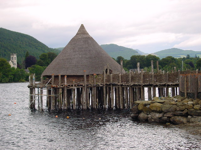
A crannog (; ga, crannóg ; gd, crannag ) is typically a partially or entirely artificial island, usually built in lakes and estuarine waters of Scotland, Wales, and Ireland. Unlike the prehistoric pile dwellings around the Alps, which were built on the shores and not inundated until later, crannogs were built in the water, thus forming artificial islands. Crannogs were used as dwellings over five millennia, from the European Neolithic Period to as late as the 17th/early 18th century. In Scotland there is no convincing evidence in the archaeological record of Early and Middle Bronze Age or Norse Period use. The radiocarbon dating obtained from key sites such as Oakbank and Redcastle indicates at a 95.4 per cent confidence level that they date to the Late Bronze Age to Early Iron Age. The date ranges fall ''after'' around 800 BC and so could be considered Late Bronze Age by only the narrowest of margins. Crannogs have been variously interpreted as free-standing wooden struct ... [...More Info...] [...Related Items...] OR: [Wikipedia] [Google] [Baidu] |


