|
Khasynsky District
Khasynsky District (russian: Хасы́нский райо́н) is an administrative district (raion), one of the eight in Magadan Oblast, Russia.Law #1292-OZ As a municipal division, it is incorporated as Khasynsky Urban Okrug.Law #1885-OZ Its administrative center is the urban locality (an urban-type settlement) of Palatka. As of the 2010 Census, the total population of the district was 8,141, with the population of Palatka accounting for 52.1% of that number. Geography It is located in the south of the oblast and borders Yagodninsky and Srednekansky Districts in the north, Omsukchansky and Olsky Districts in the east, the territory of the town of oblast significance of Magadan in the south, and Olsky and Tenkinsky Districts in the west. The area of the district is . Rivers Buyunda, Bakhapcha and Maltan flow northwards across the district at the western end of the Kolyma Mountains, in the area near the Upper Kolyma Highlands. The Arman, the Khasyn and the Yama flo ... [...More Info...] [...Related Items...] OR: [Wikipedia] [Google] [Baidu] |
Palatka, Magadan Oblast
Palatka (russian: Палатка, lit. ''tent'') is an urban locality (an urban-type settlement) and the administrative center of Khasynsky District of Magadan Oblast, Russia, located on the Kolyma Highway, northwest of Magadan and about south of Atka. Population: Geography The settlement is located by the bank of the Khasyn, flowing from the Kolyma Mountains. History The exact date of foundation of the settlement is unclear, although it began at some point in the early 1930s as the area's gold reserves were explored, and a labor camp of the gulag was built here. The first official mention was in June 1932, when the first bridge was built over the Palatka River. In 1937, there were around 3,000 held at the prison settlement. The name ''Palatka'' is identical with the Russian word for 'tent', which has been suggested as the origin of the town's name as during the early period of the settlement's history it existed largely as a collection of tents and semi-permanent structures ... [...More Info...] [...Related Items...] OR: [Wikipedia] [Google] [Baidu] |
Omsukchansky District
Omsukchansky District (russian: Омсукча́нский райо́н) is an administrativeLaw #1292-OZ district (raion), one of the eight in Magadan Oblast, Russia. As a municipal division, it is incorporated as Omsukchansky Urban Okrug.Law #1808-OZ It is located in the eastern central part of the oblast. The area of the district is . Its administrative center is the urban locality (an urban-type settlement) of Omsukchan. As of the 2010 Census, the total population of the district was 5,531, with the population of Omsukchan accounting for 75.2% of that number. History The territory of modern Omsukchansky District was originally a part of Severo-Evensky District. The split was formalized on July 16, 1954, which is considered the date of Omsukchansky District's foundation. Geography The Omsukchan Range, highest ridge of the Kolyma Mountains, rises in the district to the northwest of Omsukchan town. The Korkodon river flows across the district in its upper course. A ... [...More Info...] [...Related Items...] OR: [Wikipedia] [Google] [Baidu] |
Maymandzhin Range
The Maymandzhin Range ( rus, Майманджинский хребет) is a mountain range in Magadan Oblast, Far Eastern Federal District, Russia.Google EarthКонгинский хребет in 30 vols. / Ch. ed. – 3rd ed. – M, 1969-1978. One of the possible routes of the projected Lena-Kamchatka railway line is across the Maymandzhin Range. [...More Info...] [...Related Items...] OR: [Wikipedia] [Google] [Baidu] |
Yama (river)
The Yama ( rus, Яма) is a river in Magadan Oblast, Russian Far East. It is long, with a drainage basin of . The R504 Kolyma Highway passes just west of the sources of the Yama. The name of the river is probably of Koryak origin.Leontyev V.V. , Novikova K.A. ''Toponymic dictionary of the North-East of the USSR'', USSR Academy of Sciences. Magadan, 1989 - p. 445 - ISBN 5-7581-0044-7 Course The Yama has its source in the southwestern slopes of the Maymandzhin Range, at the confluence of rivers Maimandzha and Maimachan, near Atka and not far from the sources of north-heading Maltan. It flows in a roughly southeastern direction along its entire course. The last stretch of the Yama is in a marshy coastal area where it divides into multiple sleeves and where there are many small thermokarst lakes on the right bank. Finally it flows by Yamsk village into the Perevolochny estuary, separated by a landspit from Yam Bay, at the southwest end of the Shelikhov Gulf, Sea of Okhotsk.Go ... [...More Info...] [...Related Items...] OR: [Wikipedia] [Google] [Baidu] |
Khasyn
The Khasyn ( rus, Хасын) is a river in Magadan Oblast, Russian Far East, a tributary of the Arman. It is long, with a drainage basin of . The R504 Kolyma Highway runs by the riverside along a long stretch.Google Earth The name of the river originated in the Even language word ''"Khesen"'', meaning "herd".Армань - Water of Russia (in Russian) Course The river has its source in the , to the north of Karamken at an elevation of about . It flows init ...[...More Info...] [...Related Items...] OR: [Wikipedia] [Google] [Baidu] |
Arman (river)
The Arman ( rus, Армань; eve, Анманра) is a river in Magadan Oblast, Russian Far East. It is long, with a drainage basin of . The name of the Arman originated in the Even language, meaning "spring" or "mashed ice". In the upper course there are stretches where the river is known as Artelnyi (Agchakh) and Akhchan.Армань - Water of Russia (in Russian) Course The river has its source in the of the |
Upper Kolyma Highlands
The Upper Kolyma Highlands ( rus, Верхнеколымское нагорье) is a highland area in Magadan Oblast, Far Eastern Federal District, Russia. The biggest town in the highlands is Susuman. There are large deposits of gold, tin and rare metals in the Upper Kolyma Highlands. The area is relatively less desolate than other mountainous zones of Northeastern Siberia, such as the Yukaghir Highlands or the Nera Plateau. However, some of the mining operations were deemed unprofitable following the collapse of the USSR and certain settlements of the Susumansky District lost population. Only a residual population remains in Shiroky, Kholodny and Bolshevik. Other places such as Belichan and Kadykchan have become ghost towns. The R504 Kolyma Highway crosses the southern part of the highlands. Geography The Upper Kolyma Highlands are located in the upper course of the Kolyma. They are bound in the west by the Tas-Kystabyt and Suntar-Khayata ranges and to the east by the ... [...More Info...] [...Related Items...] OR: [Wikipedia] [Google] [Baidu] |
Kolyma Mountains
The Kolyma Mountains or Kolyma Upland ( rus, Колымское нагорье, r=Kolymskoye Nagorye) is a system of mountain ranges in northeastern Siberia, lying mostly within the Magadan Oblast, along the shores of the Sea of Okhotsk in the Kolyma region. The range's highest point is Mount Nevskaya (гора Невская) in the Omsukchan Range at . Geography The Kolyma Mountains stretch on a NW-SW alignment and consists of a series of plateaus and ridges punctuated by granite peaks that typically range between . To the west and southwest the Upper Kolyma Highlands are bound by the Seymchan- Buyunda Depression to the north and the Ola river basin to the south. The Yukaghir Highlands, highest point Mount Chubukulakh, rise to the northwest, the Anadyr Highlands to the north and northeast and the Koryak Highlands to the east.Google Earth Subranges Besides the Omsukchan Range, the system of the Kolyma Mountains comprises a number of subranges. Most are located in Magadan Obl ... [...More Info...] [...Related Items...] OR: [Wikipedia] [Google] [Baidu] |
Maltan
The Maltan (russian: Малтан) is a river in Magadan Oblast, Russia. It has a length of and a drainage basin of . The Maltan is the longest tributary of the Bakhapcha, of the Kolyma basin. The river flows across an uninhabited area, the nearest village is Sinegorye, located to the north. The name of the river originated in an Even word for "bend" or "curvature".Leontyev V.V. , Novikova K.A. ''Toponymic dictionary of the North-East of the USSR'', USSR Academy of Sciences. Magadan, 1989 - p. 246 - ISBN 5-7581-0044-7 Course The source of the Maltan is in the northern slopes of Mount Nukh (Гора Нух) of the Olsky Plateau area, at the western end of the Kolyma Mountains, close to the R504 Kolyma Highway. It flows near Atka in its upper course, not far from the sources of the Yama. The river heads in a NNW direction along the western slopes of the Maymandzhin Range. Finally it turns to the WNW below the southern slopes of Mount Khetinskaya (Гора Хетинская) and ... [...More Info...] [...Related Items...] OR: [Wikipedia] [Google] [Baidu] |
Bakhapcha
The Bakhapcha (russian: Бахапча; also ''"Бохапча"'') is a river in Magadan Oblast, Russia. It has a length of and a drainage basin of . The Bakhapcha is a right tributary of the upper course of the Kolyma. The nearest village is Sinegorye, located to the west of its mouth. The upper course of the river is a protected area. Course The source of the Bakhapcha is in lake Solnechnoye, a small lake located west of the Olsky Plateau (Ольское плато), at the western end of the Kolyma Mountains. The Maymandzhin Range rises to the east of the river basin. The river heads across an uninhabited area roughly northwards until its mouth. Flowing across mountainous terrain there are many rapids. In the floodplain of the middle reaches the riverbed branches into sleeves with many islands in between. Further downstream the river is slightly meandering. Finally the Bakhapcha joins the right bank of the Kolyma from its mouth, to the east of Sinegorye.Google Earth [...More Info...] [...Related Items...] OR: [Wikipedia] [Google] [Baidu] |
Buyunda
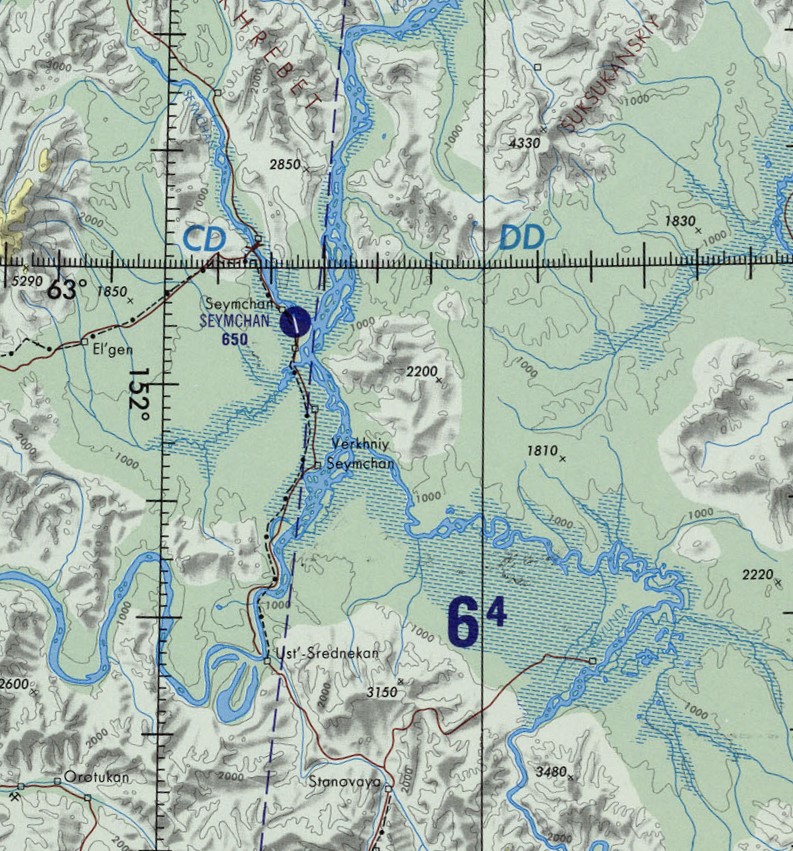
The Buyunda (russian: Буюнда) is a river in Magadan Oblast, Russian Far East. It is a right tributary of the Kolyma, with a length of and a drainage basin of .Google Earth Together with the Seymchan that flows roughly southwards on the facing bank of the Kolyma basin, the Buyunda forms the Seymchan-Buyunda Depression, which limits the Upper Kolyma Highlands from the east. The name of the Buyunda originated in the Evenki language, meaning "where there are wild deer". Course The Buyunda is the seventh longest tributary of the Kolyma. It has its sources in the Kilgan Massif and heads roughly northwards across the mountainous area of the Maymandzhin Range. After entering the depression it meanders strongly across a wide and marshy floodplain, its main channel dividing into branches. Finally the river joins the right bank of the Kolyma from its mouth. Its confluence with the Kolyma is 100 km below the Ust-Srednekan Hydroelectric Station. Seymchan settlement and the ... [...More Info...] [...Related Items...] OR: [Wikipedia] [Google] [Baidu] |
Tenkinsky District
Tenkinsky District (russian: Теньки́нский райо́н) is an administrative district (raion), one of the administrative divisions of Magadan Oblast, eight in Magadan Oblast, Russia.Law #1292-OZ As a subdivisions of Russia#Municipal divisions, municipal division, it is incorporated as Tenkinsky Urban Okrug.Law #1887-OZ Its administrative center is the types of inhabited localities in Russia, urban locality (an urban-type settlement) of Ust-Omchug. As of the Russian Census (2010), 2010 Census, the total population of the district was 5,422, with the population of Ust-Omchug accounting for 72.2% of that number. Geography The district is named after the Tenka River and is located in the southwest of Magadan Oblast. The Arman (river), Arman and Bakhapcha have their sources in the district. It borders Susumansky District, Susumansky and Yagodninsky Districts in the north, Khasynsky District in the east, Olsky District in the south, and Khabarovsk Krai in the west. The a ... [...More Info...] [...Related Items...] OR: [Wikipedia] [Google] [Baidu] |


.jpg)
