|
Kayan Lahwi
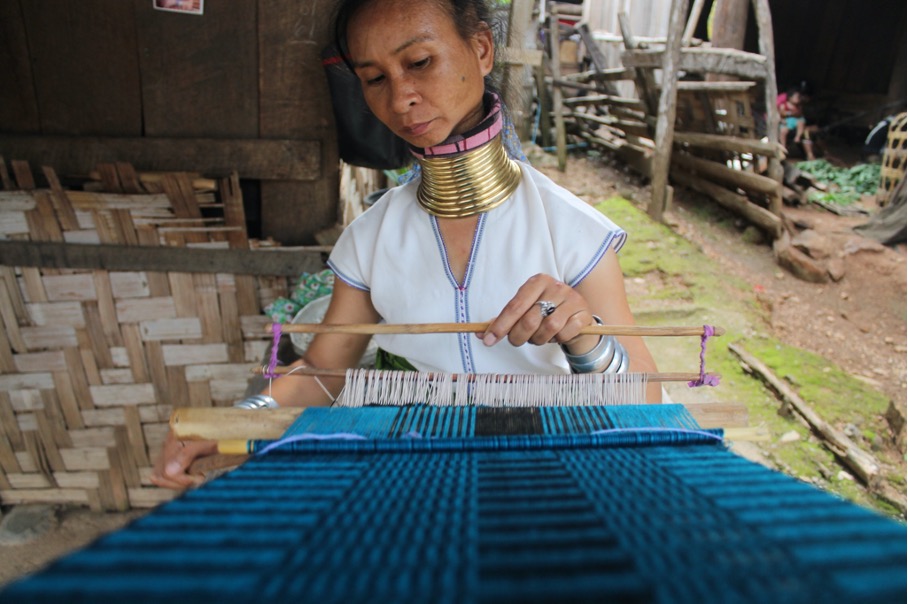
The Kayan are a sub-group of Red Karen (Karenni people), Tibeto-Burman ethnic minority of Myanmar (Burma). The Kayan consists of the following groups: Kayan Lahwi (also called Padaung, ), Kayan Ka Khaung (Gekho), Kayan Lahta, Kayan Ka Ngan. Kayan Gebar, Kayan Kakhi and, sometimes, Bwe people (Kayaw). They are distinct from, and not to be confused with, the Kayan people of Borneo. Padaung (Yan Pa Doung) is a Shan term for the Kayan Lahwi (the group in which women wear the brass neck rings). The Kayan residents in Mae Hong Son Province in Northern Thailand refer to themselves as Kayan and object to being called Padaung. In ''The Hardy Padaungs'' (1967) Khin Maung Nyunt, one of the first authors to use the term "Kayan", says that the Padaung prefer to be called Kayan. On the other hand, Pascal Khoo Thwe calls his people Padaung in his 2002 memoir, ''From the Land of Green Ghosts: A Burmese Odyssey.'' In the late 1980s and early 1990s due to conflict with the military regime i ... [...More Info...] [...Related Items...] OR: [Wikipedia] [Google] [Baidu] |
Borneo
Borneo (; id, Kalimantan) is the third-largest island in the world and the largest in Asia. At the geographic centre of Maritime Southeast Asia, in relation to major Indonesian islands, it is located north of Java, west of Sulawesi, and east of Sumatra. The island is politically divided among three countries: Malaysia and Brunei in the north, and Indonesia to the south. Approximately 73% of the island is Indonesian territory. In the north, the East Malaysian states of Sabah and Sarawak make up about 26% of the island. The population in Borneo is 23,053,723 (2020 national censuses). Additionally, the Malaysian federal territory of Labuan is situated on a small island just off the coast of Borneo. The sovereign state of Brunei, located on the north coast, comprises about 1% of Borneo's land area. A little more than half of the island is in the Northern Hemisphere, including Brunei and the Malaysian portion, while the Indonesian portion spans the Northern and Southern hemisph ... [...More Info...] [...Related Items...] OR: [Wikipedia] [Google] [Baidu] |
Pekon Township
Pekon Township (also spelled Pekhon, Phekhon, Pekong, Pecong, Pékon) is a township of Taunggyi District in the Shan State of Myanmar. The principal town is Pekon. Part of a popular tourist place and bird watching site, Inle Lake and Inlay Lake Wetland Sanctuary, lies in this township. Reportedly, the township's southern police station was occupied and razed by civilian fighters. There is an ongoing battle between civilian fighters and Myanmar Military Tatmadaw (, , ) is the official name of the armed forces of Myanmar (formerly Burma). It is administered by the Ministry of Defence and composed of the Myanmar Army, the Myanmar Navy and the Myanmar Air Force. Auxiliary services include th ... troops. References Townships of Shan State {{Shan-geo-stub ... [...More Info...] [...Related Items...] OR: [Wikipedia] [Google] [Baidu] |
Clavicle
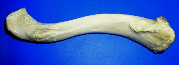
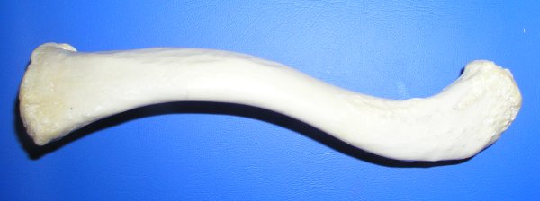
The clavicle, or collarbone, is a slender, S-shaped long bone approximately 6 inches (15 cm) long that serves as a strut between the shoulder blade and the sternum (breastbone). There are two clavicles, one on the left and one on the right. The clavicle is the only long bone in the body that lies horizontally. Together with the shoulder blade, it makes up the shoulder girdle. It is a palpable bone and, in people who have less fat in this region, the location of the bone is clearly visible. It receives its name from the Latin ''clavicula'' ("little key"), because the bone rotates along its axis like a key when the shoulder is abducted. The clavicle is the most commonly fractured bone. It can easily be fractured by impacts to the shoulder from the force of falling on outstretched arms or by a direct hit. Structure The collarbone is a thin doubly curved long bone that connects the arm to the trunk of the body. Located directly above the first rib, it acts as a strut to k ... [...More Info...] [...Related Items...] OR: [Wikipedia] [Google] [Baidu] |
Human Rib Cage
The rib cage, as an enclosure that comprises the ribs, vertebral column and sternum in the thorax of most vertebrates, protects vital organs such as the heart, lungs and great vessels. The sternum, together known as the thoracic cage, is a semi-rigid bony and cartilaginous structure which surrounds the thoracic cavity and supports the shoulder girdle to form the core part of the human skeleton. A typical human thoracic cage consists of 12 pairs of ribs and the adjoining costal cartilages, the sternum (along with the manubrium and xiphoid process), and the 12 thoracic vertebrae articulating with the ribs. Together with the skin and associated fascia and muscles, the thoracic cage makes up the thoracic wall and provides attachments for extrinsic skeletal muscles of the neck, upper limbs, upper abdomen and back. The rib cage intrinsically holds the muscles of respiration ( diaphragm, intercostal muscles, etc.) that are crucial for active inhalation and forced exhalation, and the ... [...More Info...] [...Related Items...] OR: [Wikipedia] [Google] [Baidu] |
Collar Bone
The clavicle, or collarbone, is a slender, S-shaped long bone approximately 6 inches (15 cm) long that serves as a strut between the shoulder blade and the sternum (breastbone). There are two clavicles, one on the left and one on the right. The clavicle is the only long bone in the body that lies horizontally. Together with the shoulder blade, it makes up the shoulder girdle. It is a palpable bone and, in people who have less fat in this region, the location of the bone is clearly visible. It receives its name from the Latin ''clavicula'' ("little key"), because the bone rotates along its axis like a key when the shoulder is abducted. The clavicle is the most commonly fractured bone. It can easily be fractured by impacts to the shoulder from the force of falling on outstretched arms or by a direct hit. Structure The collarbone is a thin doubly curved long bone that connects the arm to the trunk of the body. Located directly above the first rib, it acts as a strut to kee ... [...More Info...] [...Related Items...] OR: [Wikipedia] [Google] [Baidu] |
Ban Nai Soi Kayan Longneck Village
Ban, or BAN, may refer to: Law * Ban (law), a decree that prohibits something, sometimes a form of censorship, being denied from entering or using the place/item ** Imperial ban (''Reichsacht''), a form of outlawry in the medieval Holy Roman Empire * Ban (medieval), the sovereign's power to command ** King's ban (''Königsbann''), a royal command or prohibition in the medieval Holy Roman Empire * Herem (other), a Hebrew word usually translated as "the ban" * A ban could be served on people in apartheid-era South Africa People * Ban (surname), a Chinese surname * Ban (Korean name), a Korean surname and element in given names ** Ban Ki-moon, United Nations Secretary-General * King Ban, a king from the Matter of Britain * Ban (title), a noble title used in Central and Southeastern Europe (Romania, Croatia, Bosnia and Hungary) ** Banate of Bosnia ** Ban of Croatia * Matija Ban, a Croatian poet * Oana Ban, a Romanian artistic gymnast * Shigeru Ban, a Japanese architect ... [...More Info...] [...Related Items...] OR: [Wikipedia] [Google] [Baidu] |
Huai Seau Tao
The Huai River (), formerly romanized as the Hwai, is a major river in China. It is located about midway between the Yellow River and Yangtze, the two longest rivers and largest drainage basins in China, and like them runs from west to east. Historically draining directly into the Yellow Sea, floods have changed the course of the river such that it now primarily discharges into the Yangtze. The Huai is notoriously vulnerable to flooding. The Qinling–Huaihe Line, formed by the Huai River and the Qin Mountains, is sometimes regarded as the geographical dividing line between Northern and southern China. This line approximates the January isotherm and the isohyet in China. The Huai River is long with a drainage area of . Course The Huai River originates in Tongbai Mountain in Henan province. It flows through southern Henan, northern Anhui, and northern Jiangsu where it pools into Lake Hongze. Nowadays the Huai River then runs southwards as the Sanhe River by way of t ... [...More Info...] [...Related Items...] OR: [Wikipedia] [Google] [Baidu] |
Huay Pu Keng
Huay Pu Keng is a village located in the province Mae Hong Son, in the northwest of Thailand. The village is inhabited by the Tai Yai, a Thai ethnic community and four subgroups of the Karenni people, namely the Kayan, Kayaw, Red Karen and Pakayor. The Kayan women in particular became famous because tourists began to find interest in their long necks with brass rings. Geography Location Huay Pu Keng is the largest Kayan village located in Mae Hong Son province in northern Thailand, close to the Thai Myanmar border. This village is located in a remote hilly area along the Pai River, surrounded by dense rainforest. You can only reach the village by boat. Climate Northern Thailand is known for its milder weather with colder temperatures. During the months of November to February, the winter is mild and dry. Daytime temperatures are 27 °C -32 °C with plenty of sunshine. Evenings are cooler and temperatures are 9 °C -14 °C. The dry season, from Mar ... [...More Info...] [...Related Items...] OR: [Wikipedia] [Google] [Baidu] |
Mae Hong Son
Mae Hong Son ( th, แม่ฮ่องสอน, ) is a town (''thesaban mueang'') in north-west Thailand, capital of Mae Hong Son Province. It is in the Shan Hills, near the border with Burma along the banks of the River Pai. As of 2018, the town had 7,066 inhabitants. The town covers the ''tambon'' Chong Kham of the Mueang Mae Hong Son district. Mae Hong Son is north of Bangkok and northwest of Chiang Mai. History The territory of Mae Hong Son Province was formerly part of Mawkmai State, one of the Shan States which had been founded in 1767 by Hsai Khiao, hailing from a noble family of Chiang Mai. As a result of the Anglo-Siamese Boundary Commission of 1892-93 Mae Hong Son district was ceded to Siam, but the adjac ... [...More Info...] [...Related Items...] OR: [Wikipedia] [Google] [Baidu] |
Thandaung
Thandaung ( Phlone ; my, သံတောင်မြို့) is a small resort town in the Kayin State of south Myanmar. The majority of its population is Karen. It was developed as a hill station by the British British may refer to: Peoples, culture, and language * British people, nationals or natives of the United Kingdom, British Overseas Territories, and Crown Dependencies. ** Britishness, the British identity and common culture * British English, .... External links "Thandaung Map — Satellite Images of Thandaung"at Maplandia Township capitals of Myanmar Populated places in Kayin State {{Kayin-geo-stub ... [...More Info...] [...Related Items...] OR: [Wikipedia] [Google] [Baidu] |
Pyinmana Township
Pyinmana Township ( my, ပျဉ်းမနားမြို့နယ်) is one of eight townships of Naypyidaw Union Territory, Myanmar. History Historically, Pyinmana was formerly known as Ningyan (နင်းကြမ်း). Shan traders who observed the abundance of Terminalia chebula trees around the area named the city Pangmaakna (ပၢင်မၢၵ်ႇၼႃႉ), lit. "myrobalan encampment," from which the Burmese language name Pyinmana is derived. Pyinmana Township was formerly part of Mandalay Division. The township was designated as one of the original townships constituting the new capital region of Naypyidaw on 26 November 2008 by the Ministry of Home Affairs (MOHA). Demographics 2014 The 2014 Myanmar Census reported that Pyinmana Township had a population of 187,565. The population density was 170.1 people per km². The census reported that the median age was 26.6 years, and 94 males per 100 females. There were 39,663 households; the mean household size ... [...More Info...] [...Related Items...] OR: [Wikipedia] [Google] [Baidu] |
Demoso
Dimawhso ( my, ဒီးမော့ဆိုမြို့) is a town in the Kayah State of eastern part of Burma. It is ''de jure'' a part of Burma, but is currently controlled by the Karenni National People's Liberation Front The Karenni National People's Liberation Front (KNPLF) was a communist and Karenni nationalist insurgent group active in Kayah State, Myanmar (Burma). It agreed to become a government-sponsored border guard force on 8 November 2009 although ... as of 15 December 2022 as a result of the 2021–2022 Myanmar civil war. References External linksgeohack: Dimawhso Township capitals of Myanmar Populated places in Kayah State {{Kayah-geo-stub ... [...More Info...] [...Related Items...] OR: [Wikipedia] [Google] [Baidu] |


