|
Kvitegga
Kvitegga is a mountain on the border between the municipalities of Stranda and Volda in Møre og Romsdal county, Norway. It is located about southeast of the village of Leira (in Volda) and about west of Hellesylt (in Stranda). The tall Kvitegga is located about northeast of the nearby mountain Hornindalsrokken. Kvitegga is the highest mountain in the Sunnmørsalpene mountain range. It offers a very wide view, from Galdhøpiggen in the southeast (just jutting above the Sikilbreen glacier), to the impressing Hurrungane mountains further to the southeast, as well as all the local alpine surroundings and a wide swath of the ocean in the west. See also *List of peaks in Norway by prominence (Kvitegga is number 10) *List of mountains of Norway There are 291 peaks in Norway with elevations of over above sea level and that have a topographic prominence of more than 10 meters. The following list includes those 186 that have a topographic prominence of 50 meters or more. The ... [...More Info...] [...Related Items...] OR: [Wikipedia] [Google] [Baidu] |
Stranda
Stranda is a municipality in Møre og Romsdal county, Norway. It is part of the Sunnmøre region. The administrative centre of the municipality is the village of Stranda. Stranda consists of three smaller villages and one larger central village. The smaller villages are Hellesylt, Geiranger, and Liabygda. The central village, Stranda (same name as the municipality), has about 2,600 inhabitants. Stranda Municipality is known for tourist attractions like the Geirangerfjorden Sunnylvsfjorden and its skiarea at Strandafjellet The municipality is the 134th largest by area out of the 356 municipalities in Norway. Stranda is the 192nd most populous municipality in Norway with a population of 4,467. The municipality's population density is and its population has decreased by 2.9% over the previous 10-year period. General information The parish of ''Stranden'' was established as a municipality on 1 January 1838 (see formannskapsdistrikt law). On 1 January 1892, the northern distr ... [...More Info...] [...Related Items...] OR: [Wikipedia] [Google] [Baidu] |
List Of Peaks In Norway By Prominence
This is a list of the mountains of Norway, ordered by their topographic prominence. On the island Jan Mayen, a Norwegian administered island northeast of Iceland, the volcano Beerenberg has a height and prominence , and on the island Spitsbergen in Svalbard, the mountain Newtontoppen has height and prominence . For a list by height, see list of mountains in Norway by height. See also * List of mountains in Norway by height There are 291 peaks in Norway with elevations of over above sea level and that have a topographic prominence of more than 10 meters. The following list includes those 186 that have a topographic prominence of 50 meters or more. The topographic i ... * List of mountains by prominence References * * {{cite web, url=http://www.toppomania.info/toppliste.php?liste=prif1000m, title=Primary factor 1000 m+, publisher=Toppomania, accessdate=2014-01-22, url-status=dead, archiveurl=https://web.archive.org/web/20131206211251/http://toppomania.info/toppliste. ... [...More Info...] [...Related Items...] OR: [Wikipedia] [Google] [Baidu] |
Volda
Volda is a municipality in Møre og Romsdal county, Norway. It is part of the Sunnmøre region. The administrative centre is the village of Volda. Other villages in the municipality include Dravlaus, Fyrde, Straumshamn, Leira, Bjørke, and Grodås. The municipality is located about south of the town of Ålesund. The municipality is the 132nd largest by area out of the 356 municipalities in Norway. Volda is the 106th most populous municipality in Norway with a population of 10,809. The municipality's population density is and its population has increased by 9% over the previous 10-year period. General information The municipality of ''Volden'' was established on 1 January 1838 (see formannskapsdistrikt law). The original municipality was the same as the parish (prestegjeld) of Volden, including the sub-parishes of Ørsta and Dalsfjord. On 1 August 1883, the sub-parish of Ørsta (population: 2,070) was separated from Volden to form a new municipality of its own. This left V ... [...More Info...] [...Related Items...] OR: [Wikipedia] [Google] [Baidu] |
Hornindalsrokken
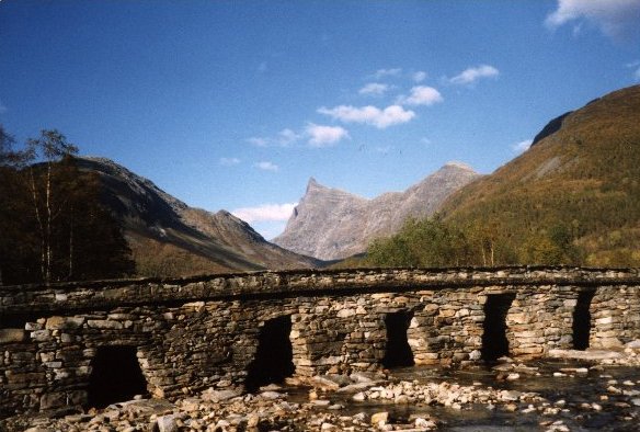
Hornindalsrokken is a tall mountain in Møre og Romsdal county, Norway. It is located on the border of two municipalities: Stranda Municipality and Volda Municipality. The mountain is sometimes also called ''Honndalsrokken'' or sometimes just ''Rokken'' or ''Rokkjen''. The mountain is located about northeast of the village of Grodås and lake Hornindalsvatnet. It is also located about west of the village of Hellesylt in Stranda Municipality. It also lies about southeast of the village of Leira in Volda Municipality. The mountain Kvitegga is to the northeast on the Ørsta/Stranda municipal border. The easiest ways to climb the mountain are from the Sæterdalen valley in Hornindal Municipality or from the Kjellstaddalen valley in Stranda Municipality. A popular viewpoint of the summit is from the Honndøla bridge which was built in 1810. The bridge lies near Norwegian County Road 60 in Indre Hornindal. North of the mountain lies the lake Tyssevatnet which is the inner ... [...More Info...] [...Related Items...] OR: [Wikipedia] [Google] [Baidu] |
Møre Og Romsdal
Møre og Romsdal (; en, Møre and Romsdal) is a county in the northernmost part of Western Norway. It borders the counties of Trøndelag, Innlandet, and Vestland. The county administration is located in the town of Molde, while Ålesund is the largest town. The county is governed by the Møre og Romsdal County Municipality which includes an elected county council and a county mayor. The national government is represented by the county governor. Name The name ''Møre og Romsdal'' was created in 1936. The first element refers to the districts of Nordmøre and Sunnmøre, and the last element refers to Romsdal. Until 1919, the county was called "Romsdalens amt", and from 1919 to 1935 "Møre fylke". For hundreds of years (1660-1919), the region was called ''Romsdalen amt'', after the Romsdalen valley in the present-day Rauma Municipality. The Old Norse form of the name was ''Raumsdalr''. The first element is the genitive case of the name ''Raumr'' derived from the name of the ... [...More Info...] [...Related Items...] OR: [Wikipedia] [Google] [Baidu] |
Norway
Norway, officially the Kingdom of Norway, is a Nordic country in Northern Europe, the mainland territory of which comprises the western and northernmost portion of the Scandinavian Peninsula. The remote Arctic island of Jan Mayen and the archipelago of Svalbard also form part of Norway. Bouvet Island, located in the Subantarctic, is a dependency of Norway; it also lays claims to the Antarctic territories of Peter I Island and Queen Maud Land. The capital and largest city in Norway is Oslo. Norway has a total area of and had a population of 5,425,270 in January 2022. The country shares a long eastern border with Sweden at a length of . It is bordered by Finland and Russia to the northeast and the Skagerrak strait to the south, on the other side of which are Denmark and the United Kingdom. Norway has an extensive coastline, facing the North Atlantic Ocean and the Barents Sea. The maritime influence dominates Norway's climate, with mild lowland temperatures on the se ... [...More Info...] [...Related Items...] OR: [Wikipedia] [Google] [Baidu] |
Mountain
A mountain is an elevated portion of the Earth's crust, generally with steep sides that show significant exposed bedrock. Although definitions vary, a mountain may differ from a plateau in having a limited Summit (topography), summit area, and is usually higher than a hill, typically rising at least 300 metres (1,000 feet) above the surrounding land. A few mountains are Monadnock, isolated summits, but most occur in mountain ranges. Mountain formation, Mountains are formed through Tectonic plate, tectonic forces, erosion, or volcanism, which act on time scales of up to tens of millions of years. Once mountain building ceases, mountains are slowly leveled through the action of weathering, through Slump (geology), slumping and other forms of mass wasting, as well as through erosion by rivers and glaciers. High elevations on mountains produce Alpine climate, colder climates than at sea level at similar latitude. These colder climates strongly affect the Montane ecosystems, ecosys ... [...More Info...] [...Related Items...] OR: [Wikipedia] [Google] [Baidu] |
List Of Municipalities Of Norway
Norway is divided into 11 administrative regions, called counties (''fylker'' in Norwegian, singular: ''fylke''), and 356 municipalities (''kommuner/-ar'', singular: ''kommune'' – cf. communes). The capital city Oslo is considered both a county and a municipality. Municipalities are the atomic unit of local government in Norway and are responsible for primary education (until 10th grade), outpatient health services, senior citizen services, unemployment and other social services, zoning, economic development, and municipal roads. Law enforcement and church services are provided at a national level in Norway. Municipalities are undergoing continuous consolidation. In 1930, there were 747 municipalities in Norway. As of 2020 there are 356 municipalities, a reduction from 422. See the list of former municipalities of Norway for further detail about municipal mergers. The consolidation effort is complicated by a number of factors. Since block grants are made by the national ... [...More Info...] [...Related Items...] OR: [Wikipedia] [Google] [Baidu] |
Hellesylt
Hellesylt is a small village in Stranda Municipality in Møre og Romsdal county, Norway. The village lies at the head of the Sunnylvsfjorden, which is a branch of the Storfjorden, and which the more famous Geirangerfjorden in turn branches off nearby. The village has a population (2018) of 258 and a population density of . There are several hundred other people living in the surrounding valley area as well. In the summertime, thousands of tourists travel through or stay in Hellesylt each day. Most of them take the ferry to the nearby village of Geiranger, which in high season runs every one and a half hours. There is also a cruise ship pier that can handle very large ships. The village is surrounded by mountains and valleys. The Sunnylven Church is located in Hellesylt, which was the administrative center of the former municipality of Sunnylven. Hellesylt is under constant threat from the mountain Åkerneset, which is about to erode into the Sunnylvsfjord. A collapse co ... [...More Info...] [...Related Items...] OR: [Wikipedia] [Google] [Baidu] |
Galdhøpiggen
Galdhøpiggen () is the highest mountain in Norway, Scandinavia, and Northern Europe. The tall mountain is located in Lom Municipality in Innlandet county, Norway. It is in the Jotunheimen mountains within Jotunheimen National Park. The mountain sits about southwest of the village of Fossbergom and about northeast of the village of Øvre Årdal. The mountain is surrounded by several other notable mountains including Keilhaus topp to the east; Store Styggehøe to the southeast; Svellnosbreahesten, Midtre Tverråtinden, and Store Tverråtinden to the south; Storjuvtinden and Skardstinden to the west; Veslpiggen, Storgrovtinden, and Storgrovhøe to the northwest; and Galdhøi and Juvvasshøi to the northeast. Etymology ''Galdhøpiggen'' means "the peak/spike ('' piggen'') of the mountain Galdhø." The first element in the name of the mountain is '' gald'' (m.) which means "steep mountain road". The last element is '' hø'' (f.) which means "(big and) rounded mountain." An old roa ... [...More Info...] [...Related Items...] OR: [Wikipedia] [Google] [Baidu] |


