|
Kurile
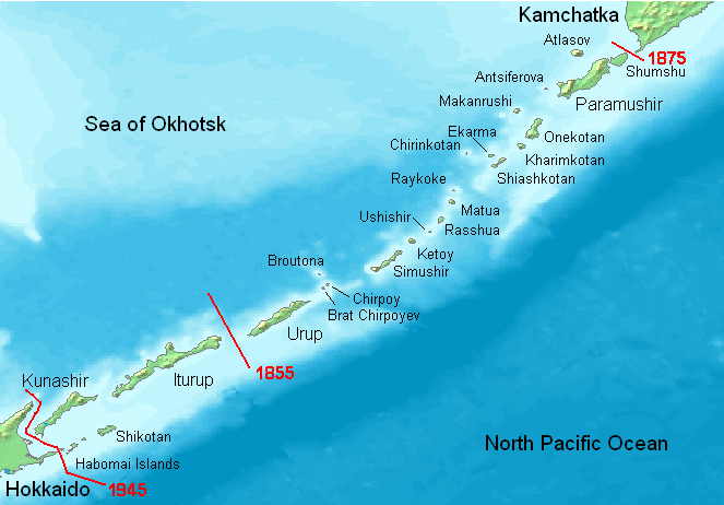
The Kuril Islands or Kurile Islands (; rus, Кури́льские острова́, r=Kuril'skiye ostrova, p=kʊˈrʲilʲskʲɪjə ɐstrɐˈva; Japanese: or ) are a volcanic archipelago currently administered as part of Sakhalin Oblast in the Russian Far East. It stretches approximately northeast from Hokkaido in Japan to Kamchatka Peninsula in Russia separating the Sea of Okhotsk from the north Pacific Ocean. There are 56 islands and many minor rocks. The Kuril Islands consist of the Greater Kuril Chain and the Lesser Kuril Chain. They cover an area of around , with a population of roughly 20,000. The islands have been under Russian administration since their 1945 invasion as the Soviet Union towards the end of World War II. Japan claims the four southernmost islands, including two of the three largest (Iturup and Kunashir), as part of its territory, as well as Shikotan and the Habomai islets, which has led to the ongoing Kuril Islands dispute. The disputed islands are know ... [...More Info...] [...Related Items...] OR: [Wikipedia] [Google] [Baidu] |
Kuril Islands Dispute
The Kuril Islands dispute, known as the Northern Territories dispute in Japan, is a territorial dispute between Japan and Russia over the ownership of the four southernmost Kuril Islands. The Kuril Islands are a chain of islands that stretch between the Japanese island of Hokkaido at their southern end and the Russian Kamchatka Peninsula at their northern end. The islands separate the Sea of Okhotsk from the Pacific Ocean. The four disputed islands, like other islands in the Kuril chain that are not in dispute, were unilaterally annexed by the Soviet Union following the Kuril Islands landing operation at the end of World War II. The disputed islands are under Russian administration as the South Kuril District and part of Kuril District of the Sakhalin Oblast (Сахалинская область, ''Sakhalinskaya oblast''). They are claimed by Japan, which refers to them as its Northern Territories or Southern Chishima, and considers them part of the Nemuro Subprefecture of ... [...More Info...] [...Related Items...] OR: [Wikipedia] [Google] [Baidu] |
Ainu People
The Ainu are the indigenous people of the lands surrounding the Sea of Okhotsk, including Hokkaido Island, Northeast Honshu Island, Sakhalin Island, the Kuril Islands, the Kamchatka Peninsula and Khabarovsk Krai, before the arrival of the Yamato Japanese and Russians. These regions are referred to as in historical Japanese texts. Official estimates place the total Ainu population of Japan at 25,000. Unofficial estimates place the total population at 200,000 or higher, as the near-total assimilation of the Ainu into Japanese society has resulted in many individuals of Ainu descent having no knowledge of their ancestry. As of 2000, the number of "pure" Ainu was estimated at about 300 people. In 1966, there were about 300 native Ainu speakers; in 2008, however, there were about 100. Names This people's most widely known ethnonym, "Ainu" ( ain, ; ja, アイヌ; russian: Айны) means "human" in the Ainu language, particularly as opposed to , divine beings. Ainu also i ... [...More Info...] [...Related Items...] OR: [Wikipedia] [Google] [Baidu] |
Habomai
; ja, 歯舞群島, Habomai guntō , location = Pacific Ocean , coordinates = , archipelago = Kuril Islands , total_islands = 10 + several rocks , major_islands = , area_km2 = 100 , length = , width = , coastline = , highest_mount = , elevation = , country_claim = , country_claim_divisions_title_1 = Prefecture , country_claim_divisions_1 = Hokkaido , country_claim_divisions_title_2 = Subprefecture , country_claim_divisions_2 = Nemuro , country = , country_admin_divisions_title_1 = Federal subject , country_admin_divisions_1 = Sakhalin Oblast , country_admin_divisions_title_2 = District , country_admin_divisions_2 = Yuzhno-Kurilsky , population = 0 , population_as_of = , density = , ethnic_groups = , additional_info = The Habomai Is ... [...More Info...] [...Related Items...] OR: [Wikipedia] [Google] [Baidu] |
Kunashir
, other_names = kz, Kün Ashyr; ja, 国後島 , location = Sea of Okhotsk , locator_map = File:Kurily Kunashir.svg , coordinates = , archipelago = Kuril Islands , total_islands = , major_islands = , area = , length = , width = from to , coastline = , highest_mount = Chacha , elevation = , country = , country_admin_divisions_title_1 = Federal subject , country_admin_divisions_1 = Sakhalin Oblast , country_admin_divisions_title_2 = District , country_admin_divisions_2 = Yuzhno-Kurilsky , country_largest_city = , country_largest_city_population = , country_leader_title = , country_leader_name = , population = approx. 7000 , population_as_of = 2007 , density = , ethnic_groups = , additional_info = , country_claim = , country_claim_divisions_title_1 = Prefecture , country_claim_divisions_1 = Hokkaido , country_claim_divisions_titl ... [...More Info...] [...Related Items...] OR: [Wikipedia] [Google] [Baidu] |
Invasion Of The Kuril Islands
The Invasion of the Kuril Islands (russian: Курильская десантная операция, lit=Kuril Islands Landing Operation) was the World War II Soviet military operation to capture the Kuril Islands from Japan in 1945. The invasion, part of the Soviet–Japanese War, was decided on when plans to land on Hokkaido were abandoned. The successful military operations of the Red Army at Mudanjiang and during the Invasion of South Sakhalin created the necessary prerequisites for invasion of the Kuril Islands. Order of battle ;Soviet Union * 2nd Far Eastern Front **87th Rifle Corps *** 355th Rifle Division ***113th Separate Rifle Brigade ** 56th Rifle Corps ***2nd Rifle Brigade **Kamchatka Defense Area *** 101st Rifle Division ***Separate Rifle Regiment ***128th Composite Air Division (78 aircraft) *Soviet Pacific Fleet (operating from Paul naval base) **60 ships and vessels including transports **2nd Independent Naval Aviation Bomber Regiment **Coastal Artillery b ... [...More Info...] [...Related Items...] OR: [Wikipedia] [Google] [Baidu] |
Iturup
, other_names = russian: Итуру́п; ja, 択捉島 , location = Sea of Okhotsk , coordinates = , archipelago = Kuril Islands , total_islands = , major_islands = , area_km2 = 3139 , length_km = 200 , width_km = 27 , coastline = , highest_mount = Stokap , elevation_m = 1634 , country_claim = , country_claim_divisions_title_1 = Prefecture , country_claim_divisions_1 = Hokkaido , country_claim_divisions_title_2 = Subprefecture , country_claim_divisions_2 = Nemuro , country = , country_admin_divisions_title_1 = Federal subject , country_admin_divisions_1 = Sakhalin Oblast , country_admin_divisions_title_2 = District , country_admin_divisions_2 = Kurilsky , population = 7,500 , population_as_of = 2003 , density = , ethnic_groups = , additional_info = Iturup (russian: Остров Итуру́п, Ostrov Iturúp; ain, エツ゚ヲロㇷ゚� ... [...More Info...] [...Related Items...] OR: [Wikipedia] [Google] [Baidu] |
Nemuro Subprefecture
is a subprefecture of Hokkaido Prefecture, Japan. Japan claims the southern parts of the disputed Kuril Islands (known as the Northern Territories in Japan) as part of this subprefecture. As of March 2009, the subprefecture has an estimated population of 84,035, and an area of 3406.23 km². Nakashibetsu Airport, the easternmost airport in Japan, is located in the town of Nakashibetsu, Shibetsu District. History *November 1897: Nemuro Subprefecture established. *November 1897: Shana Subprefecture established. *December 1903: Shana Subprefecture and Nemuro Subprefecture merged. *August 1945: Soviets occupied the Kuril Islands. Geography Municipalities Districts in the Northern Territories :Also known as the Southern Kuril Islands (administered by Russia, claimed by Japan; see Kuril Islands dispute): Districts renounced in San Francisco Treaty *Uruppu (Urup) * Shimushiru (Simushir) * Shumushu (Shumshu) Islands * Habomai Rocks * Shikotan Island * Kunashiri * ... [...More Info...] [...Related Items...] OR: [Wikipedia] [Google] [Baidu] |
Shikotan
; ja, 色丹島 , location = Pacific Ocean , coordinates = , archipelago = Kuril Islands , total_islands = 1 , major_islands = , area_km2 = 225 , length = , width = , coastline = , highest_mount = Mount Tomari , elevation_m = 412 , country_claim = , country_claim_divisions_title_1 = Prefecture , country_claim_divisions_1 = Hokkaido , country_claim_divisions_title_2 = Subprefecture , country_claim_divisions_2 = Nemuro , country = , country_admin_divisions_title_1 = Federal subject , country_admin_divisions_1 = Sakhalin Oblast , country_admin_divisions_title_2 = District , country_admin_divisions_2 = Yuzhno-Kurilsky , population = 2,100 , population_as_of = , density = , ethnic_groups = , additional_info = Shikotan (Russian: Шик� ... [...More Info...] [...Related Items...] OR: [Wikipedia] [Google] [Baidu] |
Sakhalin Oblast
Sakhalin Oblast ( rus, Сахали́нская о́бласть, r=Sakhalínskaya óblast', p=səxɐˈlʲinskəjə ˈobləsʲtʲ) is a federal subjects of Russia, federal subject of Russia (an oblast) comprising the island of Sakhalin and the Kuril Islands in the Russian Far East. The oblast has an area of . Its administrative center and largest types of inhabited localities in Russia, city is Yuzhno-Sakhalinsk. As of the Russian Census (2010), 2010 Census, the oblast has a population of roughly 500,000. The vast majority of the oblast's residents are ethnic Russians, with a small minority of Koreans. Sakhalin Oblast is rich in natural gas and oil, and is List of federal subjects of Russia by GDP per capita, Russia's fourth wealthiest federal subject and wealthiest oblast. It borders by sea Khabarovsk Krai to the west and Kamchatka Krai to the north, along with Hokkaido, Japan to the south. Demographics Population: ;Vital statistics for 2012 *Births: 6,316 (12.8 per 1,000) *D ... [...More Info...] [...Related Items...] OR: [Wikipedia] [Google] [Baidu] |
Kamchatka Peninsula
The Kamchatka Peninsula (russian: полуостров Камчатка, Poluostrov Kamchatka, ) is a peninsula in the Russian Far East, with an area of about . The Pacific Ocean and the Sea of Okhotsk make up the peninsula's eastern and western coastlines, respectively. Immediately offshore along the Pacific coast of the peninsula runs the Kuril–Kamchatka Trench. The Kamchatka Peninsula, the Commander Islands, and the Karaginsky Island, constitute the Kamchatka Krai of the Russia, Russian Federation. The vast majority of the 322,079 inhabitants are ethnic Russians, although about 13,000 are Koryaks (2014). More than half of the population lives in Petropavlovsk-Kamchatsky (179,526 in 2010) and nearby Yelizovo (38,980). The Kamchatka peninsula contains the volcanoes of Kamchatka, a World Heritage Site, UNESCO World Heritage Site. Geography Politically, the peninsula forms part of Kamchatka Krai. The southern tip is called Cape Lopatka. (Lopatka is Russian for s ... [...More Info...] [...Related Items...] OR: [Wikipedia] [Google] [Baidu] |
Lesser Kuril Chain
The Lesser Kuril Chain (russian: Малая Курильская гряда, ja, しょうクリルれっとう or 小千島列島), is an island chain in the northwestern Pacific Ocean The Pacific Ocean is the largest and deepest of Earth's five oceanic divisions. It extends from the Arctic Ocean in the north to the Southern Ocean (or, depending on definition, to Antarctica) in the south, and is bounded by the conti .... The islands are administered as part of Yuzhno-Kurilsky District of Sakhalin Oblast, Russia, and many sources consider the chain to be geographically part of the Kuril Islands. However, the Japanese government Kuril Islands dispute, claims that these islands are not part of the Kuril Islands and are instead minor islands of Hokkaido Prefecture. The Lesser Kuril Chain lies northeast of the Nemuro Peninsula in Hokkaido, near the southwestern end of the Greater Kuril Chain, from which it is separated by the South Kuril Strait. It consists of Shikotan ... [...More Info...] [...Related Items...] OR: [Wikipedia] [Google] [Baidu] |
Greater Kuril Chain
Greater Kuril Chain (russian: Большая Курильская гряда) - A part of the Kuril Islands, the Greater Kuril Chain is a group of islands in the Pacific Ocean. It includes North Kurils, Iturup and Kunashir. At its south western end, the Greater Kuril Chain is separated from Lesser Kuril Chain by the South Kuril Strait. Maximum height in the Greater Kuril Chain is 2339 m (Atlasov Island). Length - 1200 km. Total Area - 10,100 km². Greater Kuril Chain is part of Sakhalin Oblast of Russia. Iturup , other_names = russian: Итуру́п; ja, 択捉島 , location = Sea of Okhotsk , coordinates = , archipelago = Kuril Islands , total_islands = , major_islands = , area_km2 = 3139 , length_km = 200 , width_km = 27 , coastline = , highest_moun ... and Kunashir are under Russian control, but this is disputed by Japan. References Islands of the Kuril Islands {{SakhalinOblast-geo-stub ... [...More Info...] [...Related Items...] OR: [Wikipedia] [Google] [Baidu] |


