|
Kundapura, Karnataka
Kundapur, also called Kundapura, is a coastal town situated in the Udupi district of the state of Karnataka, India. This town was known as Coondapoor while it was part of the erstwhile South Canara district (1862–1947) of the Madras Presidency of British India. Present-day Kundapur is administered by the Kundapur Town Municipal Council and serves as the headquarters of the Kundapur Taluk of Udupi district. History The name Kundapura can be traced to the Kundeshwara Temple built by Kundavarma of the Alupa dynasty who ruled the region in the 10th - 11th century, in the vicinity of the Panchagangavalli River. In Kundagannada language, the word "Kunda" also refers to the flower Jasmine.Where the Majority people of Kundapura grow flower Jasmine in this region which came to be called as kundapura(Land of Jasmine). Kundapura is surrounded by water from three sides. To the north lies the Panchagangavalli River. To the east lies the Kalaghar river. To the west lie the Kodi ba ... [...More Info...] [...Related Items...] OR: [Wikipedia] [Google] [Baidu] |
River
A river is a natural flowing watercourse, usually freshwater, flowing towards an ocean, sea, lake or another river. In some cases, a river flows into the ground and becomes dry at the end of its course without reaching another body of water. Small rivers can be referred to using names such as Stream#Creek, creek, Stream#Brook, brook, rivulet, and rill. There are no official definitions for the generic term river as applied to Geographical feature, geographic features, although in some countries or communities a stream is defined by its size. Many names for small rivers are specific to geographic location; examples are "run" in some parts of the United States, "Burn (landform), burn" in Scotland and northeast England, and "beck" in northern England. Sometimes a river is defined as being larger than a creek, but not always: the language is vague. Rivers are part of the water cycle. Water generally collects in a river from Precipitation (meteorology), precipitation through a ... [...More Info...] [...Related Items...] OR: [Wikipedia] [Google] [Baidu] |
Mangalore
Mangalore (), officially known as Mangaluru, is a major port city of the Indian state of Karnataka. It is located between the Arabian Sea and the Western Ghats about west of Bangalore, the state capital, 20 km north of Karnataka–Kerala border, 297 km south of Goa. Mangalore is the state's only city to have all four modes of transport—air, road, rail and sea. The population of the urban agglomeration was 619,664 national census of India. It is known for being one of the locations of the Indian strategic petroleum reserves. The city developed as a port in the Arabian Sea during ancient times, and has since become a major port of India that handles 75 percent of India's coffee and cashew exports. It is also the country's seventh largest container port. Mangalore has been ruled by several major powers, including the Kadambas, Alupas, Vijayanagar Empire, Keladi Nayaks, and the Portuguese. The city was a source of contention between the British a ... [...More Info...] [...Related Items...] OR: [Wikipedia] [Google] [Baidu] |
Panchagangavalli River
Panchagangavalli River is a river flowing through Kundapur and Gangolli in western India. The five rivers namely Souparnika River, Varahi River, Kedaka River, Chakra River and Kubja River join and merge into Arabian sea The Arabian Sea ( ar, اَلْبَحرْ ٱلْعَرَبِيُّ, Al-Bahr al-ˁArabī) is a region of the northern Indian Ocean bounded on the north by Pakistan, Iran and the Gulf of Oman, on the west by the Gulf of Aden, Guardafui Channel .... References Rivers of Karnataka Rivers of India {{India-river-stub ... [...More Info...] [...Related Items...] OR: [Wikipedia] [Google] [Baidu] |
Alupa Dynasty
The Alupa dynasty (ಅಳುಪೆರ್, ಆಳ್ವೆರ್) (circa 2nd century C.E to 15th century C.E) was an ancient ruling dynasty of India. The kingdom they ruled was known as ''Alvakheda Arusasira'' and its territory spanned the coastal districts of the modern Indian state known as Karnataka. The Alupas in their prime were an independent dynasty, centuries after reigning due to the dominance of Kadambas from Banavasi, they became feudatory to them. Later they became the vassals of the Chalukyas, Rashtrakutas, Hoysalas with the change in political scenario of Southern India. Their influence over coastal Karnataka lasted for about 1200 years. There is evidence that the Alupas followed the law of matrilineal inheritance ( Appekatt/Aliyasantana) since the Alupa king Soyideva was succeeded by his nephew Kulasekhara Bankideva (son of Alupa princess Krishnayitayi and Hoysala Veera Ballala III). The legendary king who is credited with introducing matrilineality in Alva Kh ... [...More Info...] [...Related Items...] OR: [Wikipedia] [Google] [Baidu] |
Kundapur Taluk
Kundapura Taluk is a taluk located in Udupi district in the Indian state of Karnataka. Kundapur town is the taluk headquarters of Kundapur Taluk. Demographics As of the 2011 Census of India, Kundapura Taluk had 79573 households with a population of 398471 of who 357798 were from rural areas and 40673 from urban. Of the population, 295664 people were literate. Geography Kundapur Taluk is bounded on the west by the Arabian Sea, on the south by Brahmavara Taluk, on the north by Byndoor Taluk Byndoor is an Coastal Town and the Headquarters of Byndoor Taluk in the Udupi District of Karnataka state, India. It is situated at a distance of about from the state capital Bengaluru and at about from the Udupi district headquarters, ar ..., and the east by the Western Ghats. Rivers This taluk has several rivers and experiences heavy rainfall. The main rivers are the Chakra, Souparnika, Varahi, Kubja, and Kheta. In fact, there are seven rivers or rivulets between Kundapur and B ... [...More Info...] [...Related Items...] OR: [Wikipedia] [Google] [Baidu] |
British India
The provinces of India, earlier presidencies of British India and still earlier, presidency towns, were the administrative divisions of British governance on the Indian subcontinent. Collectively, they have been called British India. In one form or another, they existed between 1612 and 1947, conventionally divided into three historical periods: *Between 1612 and 1757 the East India Company set up Factory (trading post), factories (trading posts) in several locations, mostly in coastal India, with the consent of the Mughal emperors, Maratha Empire or local rulers. Its rivals were the merchant trading companies of Portugal, Denmark, the Netherlands, and France. By the mid-18th century, three ''presidency towns'': Madras, Bombay and Calcutta, had grown in size. *During the period of Company rule in India (1757–1858), the company gradually acquired sovereignty over large parts of India, now called "presidencies". However, it also increasingly came under British government over ... [...More Info...] [...Related Items...] OR: [Wikipedia] [Google] [Baidu] |
Madras Presidency
The Madras Presidency, or the Presidency of Fort St. George, also known as Madras Province, was an administrative subdivision (presidency) of British India. At its greatest extent, the presidency included most of southern India, including the whole of the Indian states of Tamil Nadu, Andhra state and some parts of Kerala, Karnataka, Odisha and the union territory of Lakshadweep. The city of Madras was the winter capital of the Presidency and Ootacamund or Ooty, the summer capital. The coastal regions and northern part of Island of Ceylon at that time was a part of Madras Presidency from 1793 to 1798 when it was created a Crown colony. Madras Presidency was neighboured by the Kingdom of Mysore on the northwest, Kingdom of Cochin on the southwest, and the Kingdom of Hyderabad on the north. Some parts of the presidency were also flanked by Bombay Presidency ( Konkan) and Central Provinces and Berar (Madhya Pradesh). In 1639, the English East India Company purchased the vi ... [...More Info...] [...Related Items...] OR: [Wikipedia] [Google] [Baidu] |
South Canara
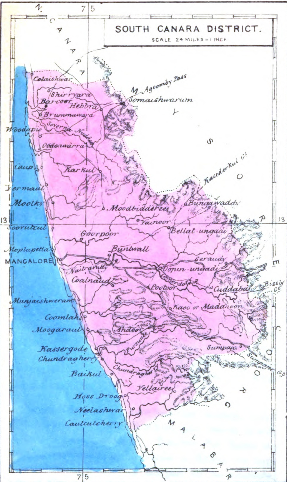
South Canara was a district of the Madras Presidency of British India, located at . It comprised the towns of Kassergode and Udipi and adjacent villages, with the capital in Mangalore city. South Canara was one of the most heterogeneous areas of Madras Presidency, with Tulu, Malayalam, Kannada, Konkani, Marathi, Urdu, and Beary languages being spoken side by side. It was succeeded by the Tulu-speaking areas of Dakshina Kannada district, the Malayalam-speaking area of Kasaragod district and the Amindivi islands sub-division of the Laccadives, in the year 1956. Geography Mangalore was the administrative headquarters of the district. The district covered an area of . South Canara District was bordered by North Canara to north, the princely state of Mysore to east, Coorg state to southeast, Malabar District to south, and Arabian Sea to west. South Canara was one of the two districts on the western coast (Malabar coast) of Madras Presidency along with Malabar District (otherwi ... [...More Info...] [...Related Items...] OR: [Wikipedia] [Google] [Baidu] |
Vidhan Sabha
The State Legislative Assembly, or Vidhan Sabha, or also Saasana Sabha, is a legislative body in the states and union territories of India. In the 28 states and 3 union territories with a unicameral state legislature, it is the sole legislative body and in 6 states it is the lower house of their bicameral state legislatures with the upper house being State Legislative Council. 5 union territories are governed directly by the Union Government of India and have no legislative body. Each Member of the Legislative Assembly (MLA) is directly elected to serve 5-year terms by single-member constituencies. The Constitution of India states that a State Legislative Assembly must have no less than 60 and no more than 500 members however an exception may be granted via an Act of Parliament as is the case in the states of Goa, Sikkim, Mizoram and the union territory of Puducherry which have fewer than 60 members. A State Legislative Assembly may be dissolved in a state of emergency, b ... [...More Info...] [...Related Items...] OR: [Wikipedia] [Google] [Baidu] |
Lok Sabha
The Lok Sabha, constitutionally the House of the People, is the lower house of India's bicameral Parliament, with the upper house being the Rajya Sabha. Members of the Lok Sabha are elected by an adult universal suffrage and a first-past-the-post system to represent their respective constituencies, and they hold their seats for five years or until the body is dissolved by the President on the advice of the council of ministers. The house meets in the Lok Sabha Chambers of the Sansad Bhavan, New Delhi. The maximum membership of the House allotted by the Constitution of India is 552 (Initially, in 1950, it was 500). Currently, the house has 543 seats which are made up by the election of up to 543 elected members and at a maximum. Between 1952 and 2020, 2 additional members of the Anglo-Indian community were also nominated by the President of India on the advice of Government of India, which was abolished in January 2020 by the 104th Constitutional Amendment Act, 2019. The ... [...More Info...] [...Related Items...] OR: [Wikipedia] [Google] [Baidu] |
Bicameralism
Bicameralism is a type of legislature, one divided into two separate Deliberative assembly, assemblies, chambers, or houses, known as a bicameral legislature. Bicameralism is distinguished from unicameralism, in which all members deliberate and vote as a single group. , about 40% of world's national legislatures are bicameral, and about 60% are unicameral. Often, the members of the two chambers are elected or selected by different methods, which vary from Jurisdiction (area), jurisdiction to jurisdiction. This can often lead to the two chambers having very different compositions of members. Enactment of a bill, Enactment of primary legislation often requires a concurrent majority—the approval of a majority of members in each of the chambers of the legislature. When this is the case, the legislature may be called an example of perfect bicameralism. However, in many parliamentary and semi-presidential systems, the house to which the executive is Responsible government, responsi ... [...More Info...] [...Related Items...] OR: [Wikipedia] [Google] [Baidu] |
Female
Female (Venus symbol, symbol: ♀) is the sex of an organism that produces the large non-motile ovum, ova (egg cells), the type of gamete (sex cell) that fuses with the Sperm, male gamete during sexual reproduction. A female has larger gametes than a male. Females and males are results of the anisogamous reproduction system, wherein gametes are of different sizes, unlike isogamy where they are the same size. The exact mechanism of female gamete evolution remains unknown. In species that have males and females, Sex-determination system, sex-determination may be based on either sex chromosomes, or environmental conditions. Most female mammals, including female humans, have two X chromosomes. Female characteristics vary between different species with some species having pronounced Secondary sex characteristic, secondary female sex characteristics, such as the presence of pronounced mammary glands in mammals. In humans, the word ''female'' can also be used to refer to gender i ... [...More Info...] [...Related Items...] OR: [Wikipedia] [Google] [Baidu] |


