|
Krýsuvík Fires
The Krýsuvík fires were a period of volcanic activity in a fissure swarm known as Krýsuvík (volcanic system), Krýsuvík (:is: Krýsuvíkureldar) on the Reykjanes peninsula. The fires started in the middle of the 12th century, probably in 1151 and written sources indicate that they ended in 1188. Lava flows associated with the Krýsuvík fires are Ögmundarhraun, Mávahlíðahraun and Kapelluhraun . See also * List of volcanic eruptions on Iceland * Krýsuvík (volcanic system) * Volcanism of Iceland * Geology of Iceland * List of volcanoes in Iceland * Geological deformation of Iceland * Global Volcanism Program References External links Catalogue of Icelandic Volcanoes Mountains of Iceland Active volcanoes One-thousanders of Iceland Volcanic systems of Iceland Krýsuvík Volcanic System Reykjanes Volcanic Belt Fissure vents Southern Region (Iceland) {{Volcano-stub ... [...More Info...] [...Related Items...] OR: [Wikipedia] [Google] [Baidu] |
Krýsuvík
Krýsuvík (also Krísuvík, both pronounced in Icelandic language, Icelandic) is an area in Southwest (Icelandic constituency), Southwest Iceland at about 35 km from Reykjavík. Geography and access It is situated on the Reykjanes peninsula between Þorlákshöfn and Grindavík and accessed by Routes 42 and 427. Name The name Krýsuvík means "bay of Krýsa," a folk tale figure from the area. ''Krýsa'' was an old woman who, together with her cousin ''Herdís,'' could use witchcraft. They had a discussion about the borders of their respective lands; one wanted to cast a spell so that all the fish in a nearby lake would be hairy, the other intended to bring up a storm and let all fishermen die. The dispute ended with the death of both of them. The folk tale says that they were buried side by side, and the place of the graves is still known to locals. The ''Ögmundarhraun'' lava flows which were emitted by the nearby Krýsuvík (volcanic system), Krýsuvík volcanic s ... [...More Info...] [...Related Items...] OR: [Wikipedia] [Google] [Baidu] |
List Of Volcanoes In Iceland
There are too many presumed extinct or now inactive volcanic features to list all of these below, so most monogenetic volcanoes can not be mentioned individually. This list of volcanoes in Iceland only includes major active and dormant volcano, volcanic mountains, of which at least 18 vents have erupted since human settlement of Iceland began around 900 AD. Subsequent to the main list a list is presented that classifies the volcanoes into zones, systems and types. This is in the context that there are several classification systems and many of the volcanoes may have separate shallow magma chambers and a deeper common magma source. Where a major vent is part of a larger volcano this is indicated in the list comment. Since some of these vent eruptions have been very large, disruptive or been regarded in popular culture as a separate volcano they have been included in the list but where this is not the case it is not appropriate to duplicate or create entries. So for minor vent eru ... [...More Info...] [...Related Items...] OR: [Wikipedia] [Google] [Baidu] |
Reykjanes Volcanic Belt
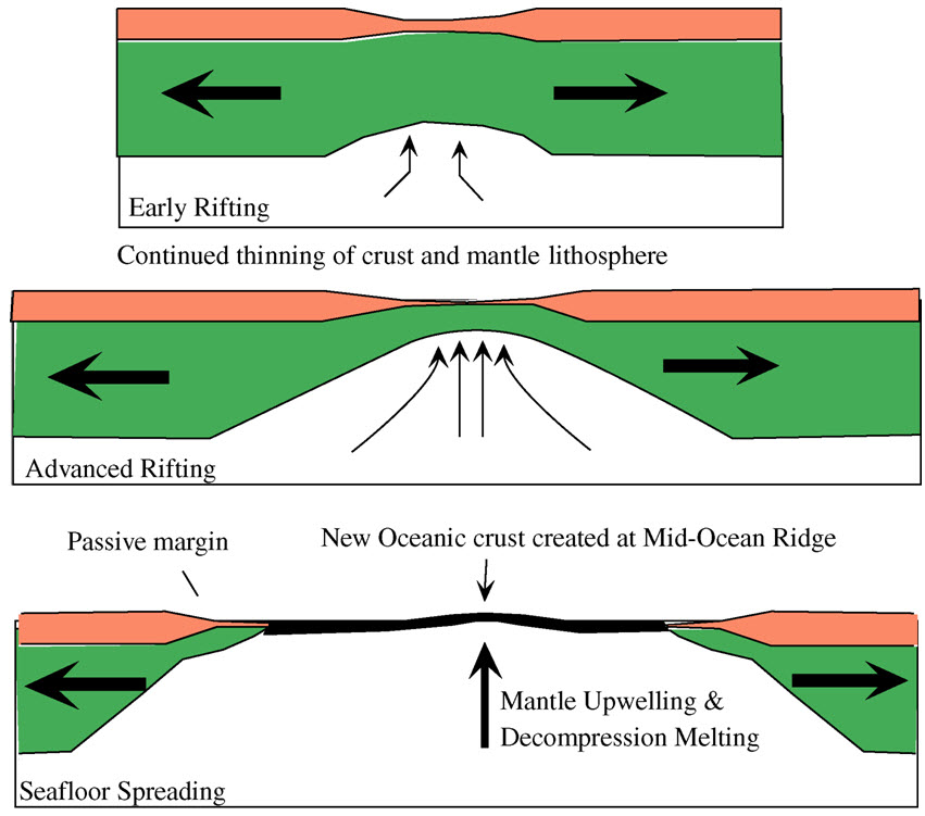
The Reykjanes Peninsula ( ) in southwest Iceland is the continuation of the mostly submarine Reykjanes Ridge, a part of the Mid-Atlantic Ridge, on land and reaching from Esjan, Esja in the north and Hengill in the east to Reykjanestá in the west. Suðurnes (transl. Southern Peninsula (Iceland), Southern Peninsula) is an administrative unit covering part of Reykjanes Peninsula. A great deal of volcanic activity was occurring in the Reykjanes Peninsula in 2020 and into 2024, after nearly 800 years of inactivity. After the eruption of the Fagradalsfjall volcano on 19 March 2021, National Geographic's experts predicted that this "may mark the start of decades of volcanic activity". The eruption was small leading to a prediction that this volcano was unlikely to threaten "any population centers". Origin The two most important factors for the existence of Iceland, rifting in combination with the Iceland hotspot, were responsible for the existence of Reykjanesskagi. Reykjanes Penin ... [...More Info...] [...Related Items...] OR: [Wikipedia] [Google] [Baidu] |
Krýsuvík Volcanic System
Krýsuvík (also Krísuvík, both pronounced in Icelandic) is an area in Southwest Iceland at about 35 km from Reykjavík. Geography and access It is situated on the Reykjanes peninsula between Þorlákshöfn and Grindavík and accessed by Routes 42 and 427. Name The name Krýsuvík means "bay of Krýsa," a folk tale figure from the area. ''Krýsa'' was an old woman who, together with her cousin ''Herdís,'' could use witchcraft. They had a discussion about the borders of their respective lands; one wanted to cast a spell so that all the fish in a nearby lake would be hairy, the other intended to bring up a storm and let all fishermen die. The dispute ended with the death of both of them. The folk tale says that they were buried side by side, and the place of the graves is still known to locals. The ''Ögmundarhraun'' lava flows which were emitted by the nearby Krýsuvík volcanic system in the 12th century, destroyed the Krýsuvík farm, which was located at the ... [...More Info...] [...Related Items...] OR: [Wikipedia] [Google] [Baidu] |
Volcanic Systems Of Iceland
:''The volcano system in Iceland that started activity on August 17, 2014, and ended on February 27, 2015, is Bárðarbunga.'' :''The volcano in Iceland that erupted in May 2011 is Grímsvötn.'' Iceland experiences frequent volcanic activity, due to its location both on the Mid-Atlantic Ridge, a divergent tectonic plate boundary, and being over a hotspot. Nearly thirty volcanoes are known to have erupted in the Holocene epoch; these include Eldgjá, source of the largest lava eruption in human history. Some of the various eruptions of lava, gas and ash have been both destructive of property and deadly to life over the years, as well as disruptive to local and European air travel. Volcanic systems and volcanic zones of Iceland Holocene volcanism in Iceland is mostly to be found in the ''Neovolcanic Zone'', comprising the Reykjanes volcanic belt (RVB), the West volcanic zone (WVZ), the Mid-Iceland belt (MIB), the East volcanic zone (EVZ) and the North volcanic zone (NVZ) ... [...More Info...] [...Related Items...] OR: [Wikipedia] [Google] [Baidu] |
Active Volcanoes
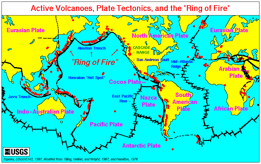
An active volcano is a volcano that is currently erupting, or has the potential to erupt in the future. Conventionally it is applied to any that have erupted during the Holocene (the current geologic epoch that began approximately 11,700 years ago). A volcano that is not currently erupting but could erupt in the future is known as a dormant volcano. Volcanoes that will not erupt again are known as extinct volcanoes. Overview There are 1,350 potentially active volcanoes around the world, 500 of which have erupted in historical time. Many active volcanoes are located along the Pacific Rim, also known as the Pacific Ring of Fire. An estimated 500 million people live near active volcanoes. ''Historical time'' (or recorded history) is another timeframe for ''active''. The span of recorded history differs from region to region. In China and the Mediterranean, it reaches back nearly 3,000 years, but in the Pacific Northwest of the United States and Canada, it reaches back less tha ... [...More Info...] [...Related Items...] OR: [Wikipedia] [Google] [Baidu] |
Mountains Of Iceland
A mountain is an elevated portion of the Earth's crust, generally with steep sides that show significant exposed bedrock. Although definitions vary, a mountain may differ from a plateau in having a limited summit area, and is usually higher than a hill, typically rising at least above the surrounding land. A few mountains are isolated summits, but most occur in mountain ranges. Mountains are formed through tectonic forces, erosion, or volcanism, which act on time scales of up to tens of millions of years. Once mountain building ceases, mountains are slowly leveled through the action of weathering, through slumping and other forms of mass wasting, as well as through erosion by rivers and glaciers. High elevations on mountains produce colder climates than at sea level at similar latitude. These colder climates strongly affect the ecosystems of mountains: different elevations have different plants and animals. Because of the less hospitable terrain and climate, mountains te ... [...More Info...] [...Related Items...] OR: [Wikipedia] [Google] [Baidu] |
Global Volcanism Program
The Smithsonian Institution's Global Volcanism Program (GVP) documents Earth's volcanoes and their eruptive history during the Quaternary Period of Earth's geologic history, with particular emphasis on volcanic activity during the Holocene Epoch (the last 11,700 years). The mission of the GVP is to document, understand, and disseminate information about global volcanic activity. Global Volcanism Program Database The GVP gathers information and reports on current eruptions from around the world, and maintains a database repository on active volcanoes, their eruptions and their eruption histories. In this way, a global context for the planet's active volcanism is presented. Smithsonian reporting on current volcanic activity dates back to 1968, with the Center for Short-Lived Phenomena (CSLP). The GVP is housed in the Department of Mineral Sciences, part of the National Museum of Natural History, on the National Mall in Washington, D.C. During the early stages of an eruption, ... [...More Info...] [...Related Items...] OR: [Wikipedia] [Google] [Baidu] |
Geological Deformation Of Iceland
The geological deformation of Iceland is the way that the rocks of the island of Iceland are changing due to tectonic forces. The geological deformation help to explain the location of earthquakes, volcanoes, fissures, and the shape of the island. Iceland is the largest landmass () situated on an oceanic ridge. It is an elevated plateau of the sea floor, situated at the crossing of the Mid-Atlantic Ridge and the Greenland-Iceland-Scotland ridge. It lies along an oceanic divergent plate boundary: the western part of Iceland sits on the North American Plate and the eastern part sits on the Eurasian Plate. The Reykjanes Ridge of the Mid-Atlantic ridge system in this region crosses the island from southwest and connects to the Kolbeinsey Ridge in the northeast. Iceland is geologically young: all rocks there were formed within the last 25 million years. It started forming in the Early Miocene sub-epoch, but the oldest rocks found at the surface of Iceland are from the Middle Miocene sub ... [...More Info...] [...Related Items...] OR: [Wikipedia] [Google] [Baidu] |
Geology Of Iceland
The geology of Iceland is unique and of particular interest to geologists. Iceland lies on the divergent boundary between the Eurasian plate and the North American plate. It also lies above a hotspot, the Iceland plume. The plume is believed to have caused the formation of Iceland itself, the island first appearing over the ocean surface about 16 to 18 million years ago. The result is an island characterized by repeated volcanism and geothermal phenomena such as geysers. The eruption of Laki in 1783 caused much devastation and loss of life, leading to a famine that killed about 25% of the island's population and resulted in a drop in global temperatures, as sulfur dioxide was spewed into the Northern Hemisphere. This caused crop failures in Europe and may have caused droughts in India. The eruption has been estimated to have killed over six million people globally. Between 1963 and 1967, the new island of Surtsey was created off the southwest coast by a volcanic eruption. ... [...More Info...] [...Related Items...] OR: [Wikipedia] [Google] [Baidu] |


