|
Koovarji Karsan Rathor
Rai Saheb Koovarji Karsan Rathor (1898–1976) was a noted Kutchi railway & civil contractor, businessman & philanthropist from Cuttack, India. Life sketch He was born to Karsan Bhima Rathor in Madhapar, who belonged to Mestri community of Kutch. His father Karsan Bhima was a noted railway contractor, who settled in Cuttack, while doing railway contract. The Shail Sadan Palace in Bolangir belonging to royal family of Patna Raj was constructed in 1910 by Karsan Bhima Rathor, Jagmal Bhima Rathor & other contractor of Kutch like Parbat Vira of Khambhra. Further, Karsan Bhima and his elder brother Jagmal Bhima were the contractors, who were involved in building of railway lines from Kharagpur to Cuttack during the years 1892 to 1898 along with other contemporary Mistri contractors like Manji Jeram of Madhapar, Khora Ramji and others from Sinugra, Khambhra, etc. In 1897 they were involved in laying the lines and building the bridge over Dhelang River in Khurda Road to ... [...More Info...] [...Related Items...] OR: [Wikipedia] [Google] [Baidu] |
Rai Saheb
Rai Sahib / Rao Saheb / Roy Sahib / Rao Sahib abbreviated R.S., was a title of honour issued during the era of British Raj, British rule in India to individuals who performed faithful service or acts of public welfare to the nation. From 1911 the title was accompanied by a special Title Badge (India), Title Badge. Translated, ''Rai'' means "King" ''sahib'' means "leader". This was the start level title usually awarded to civilians, which could later be upgraded to Rao Bahadur and then to Dewan Bahadur titles. The title styled ''Rai Sahib'' were awarded to Hindu people of North India, Rao Saheb in Maharashtra and styled ''Rao Sahib'' to Hindu people of South India, however, they were both of same category and spelling was altered to meet with regional differences of pronunciation. The Rai Sahib/Rao Sahib/Roy Sahib and other similar titles issued during British Raj were disestablished in 1947 upon independence of India. Some people awarded the title * Rao Bahadur Satyendra Nat ... [...More Info...] [...Related Items...] OR: [Wikipedia] [Google] [Baidu] |
Gondia
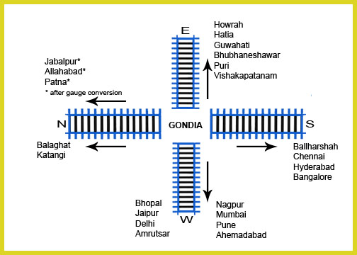
Gondia (also spelled Gondiya) is a city and municipal council in the Indian state of Maharashtra which serves the administrative headquarters of the eponymous administrative district. Gondia is also known as ''Rice City'' due to the abundance of rice mills in the area.Gondia Airport is only airport in district. Industry Adani Power Maharashtra Limited (APML), is 3 km away from Tirora on Tirora-Gondia state road. Coal is transported to Adani power, Ltd through a railway which is connected to Kachewani Railway Station. Water is being used from nearby weir constructed on Wainganga River. An 85.89% subsidiary of Adani Power Limited is implementing 3300 MW Thermal Power Station in Tirora. History The region is named after the Gondi people, an Adivasi group in central India. During British rule in India, the Great Famine of 1876–78 provided an opportunity for the construction of a metre-gauge rail link called the Nagpur Chhattisgarh Railway, connecting Nagpur with Rajnandgao ... [...More Info...] [...Related Items...] OR: [Wikipedia] [Google] [Baidu] |
Dharamshalas
A dharamshala, also written as dharmashala is a public resthouse or shelter in the Indian subcontinent. Just as sarai are for travellers and caravans, dharamshalas are built for religious travellers at pilgrimage sites. In Nepal there are dharamshalas especially built for pilgrims as well as dharamshalas for locals. Etymology ''Dharamshala'' (Devanagari: धर्मशाला; ITRANS: Dharmashaalaa; IAST: Dharmaśālā) is a word (derived from Sanskrit) that is a compound of ''dharma'' (धर्म) and ''shālā'' (शाला). A loose translation into English would be 'spiritual dwelling' or, more loosely, 'sanctuary'. Rendering a precise literal translation into English is problematic due to the vast and conceptually rich semantic field of the word ''dharma'', and the cultural aspect of India. In common Hindu usage, the word ''dharamshala'' refers to a shelter or rest house for spiritual pilgrims. Traditionally, such ''dharamshalas'' (pilgrims' rest houses) were common ... [...More Info...] [...Related Items...] OR: [Wikipedia] [Google] [Baidu] |
Brahmapur, Odisha
Brahmapur (; also known as Berhampur) is a city on the eastern coastline of Ganjam district of the Indian state of Odisha. Bramhapur is most famous for its street food, silk sarees or pato sarees, temples and many historical places. Bramhapur also dubbed as Food Capital of Odisha, and Silk City of India. Etymology The name of the city is said to have been derived from the name of Lord Brahmeswara, worshipped in a temple at Lathi, 4 km from the main town. History Jaugada, present 35 km away from Brahmapur on the banks of the Rushikulya, was an ancient fort and city existing from 3rd century BC to 7th century AD. Its existence before and after this time period cannot be ruled out. Also called ''Samapa'', it was a provincial headquarter of Maurya Dynasty along with ''Dhauli'' as evident from the edicts found at both places. Specific history about the place and civilisation doesn't exist after the Maurya Dynasty and the fort is now buried. The cult of Buddhi Thakurani o ... [...More Info...] [...Related Items...] OR: [Wikipedia] [Google] [Baidu] |
Kendrapara
Kendrapara is a Town and a municipality in the Kendrapara district of the Indian state of Odisha. It is the headquarters of Kendrapara district. Geography Kendrapara is located at . It has an average elevation of . It is surrounded by Bhadrak, Jajpur, Cuttack and Jagatsinghpur districts and the Bay of Bengal to the east. The river Chitroptala (a branch of the Mahanadi) flows through Kendrapara district. Other rivers in Kendrapara include the Luna, the Karandia, the Gobari, the Brahamani, the Birupa, the Kani, the Hansua, the Baitarani, the Kharasrota, and the Paika. This district has 9 blocks, which are Aul, Derabish, Garadpur, Mahakalapada, Marshaghai, Kendrapara, Rajanagar, Rajkanika, Pattamundai. Transport To reach Kendrapara one can take the Jagatpur- Salipur state highway SH9A or National Highways No.16 and 53. Kendrapara is a two and a half hour drive from Bhubaneswar Airport on the National Highway 16 and State Highway 9A. The nearest railway station is at Cuttack, ... [...More Info...] [...Related Items...] OR: [Wikipedia] [Google] [Baidu] |
Chilika
Chilika Lake is a brackish water lagoon, spread over the Puri, khordha and Ganjam districts of Odisha state on the east coast of India, at the mouth of the Daya River, flowing into the Bay of Bengal, covering an area of over . It is the biggest lake of India after Vembanad Lake. This lake is the largest coastal lagoon in India and the largest brackish water lagoon in the world after The New Caledonian barrier reef. It has been listed as a tentative UNESCO World Heritage site. It is a salt water lake. It is the largest wintering ground for migratory birds on the Indian sub-continent. The lake is home to a number of threatened species of plants and animals. The lake is an ecosystem with large fishery resources. It sustains more than 150,000 fisher–folk living in 132 villages on the shore and islands. The lagoon hosts over 160 species of birds in the peak migratory season. Birds from as far as the Caspian Sea, Lake Baikal, Aral Sea and other remote parts of Russia, Kirg ... [...More Info...] [...Related Items...] OR: [Wikipedia] [Google] [Baidu] |
Sundargarh
Sundergarh is a town in Sundergarh district of the Indian state of Odisha. As of 2011 2011 Census of India, census, the municipality had a population of 45,036. Sundargarh is recognized as an industrial district in Odisha. Steel, fertilizer, cement, ferrovanadium, machine-building, glass, china-clay plants and factories, and spinning mills are some of the major industries of this district. Sundargarh occupies a prominent position in the mineral map of Odisha and is rich in iron ore, limestone, and manganese. Geography Sundargarh is located at . It has an average elevation of 243 metres (801 feet). The Ib river flows along in the north. Climate The climate of this district is characterized by extremely hot summers and cool winters. The climate is hot and moist sub-humid. The normal rainfall of the district is approximately 1230 mm, but there is a deviation in receipt of rainfall pattern which is influencing crop production. History Sundargarh was the capital of ... [...More Info...] [...Related Items...] OR: [Wikipedia] [Google] [Baidu] |
Keonjhar
Kendujhar is a town with municipality in Kendujhar District in the Indian state of Odisha. It is the administrative headquarters of the Kendujhar district, and it is one of the fifth scheduled areas of Odisha. Climate Politics Mohan charan Majhi of BJP is the current MLA from Keonjhar assembly constituency. Mohan Charan Majhi won assembly elections in both 2004 and 2000. Earlier MLAs from this seat were Jogendra Naik of BJP (1995), C. Majhi of JD (1990), Chhotaray Majhi of JNP (1985), Jogendra Naik of INC(I) in 1980 and Kumar Majhi of JNP (1977). Present MP from Keonjhar (Lok Sabha constituency) is Chandrani Murmu Chandrani Murmu (born 16 June 1993) is an Indian politician. She was elected to the Lok Sabha, lower house of the Parliament of India from Keonjhar, Odisha in the 2019 Indian general election as a member of the Biju Janata Dal. Chandrani Murmu ... of BJD. Gallery Some images of keonjhar. File:KEONJHAR town as seen from above..jpg, keonjhar seen from a ... [...More Info...] [...Related Items...] OR: [Wikipedia] [Google] [Baidu] |
Mayurbhanj
Mayurbhanj district is one of the 30 districts in Odisha state in eastern India. It is the largest district of Odisha by area. Its headquarters are at Baripada. Other major towns are Rairangpur, Karanjia and Udala. , it is the third-most-populous district of Odisha (out of 30), after Ganjam and Cuttack. Etymology The name of the district is a portmanteau of '' Mayura'' (meaning peacock in Odia) and '' Bhanja'', the name of the two ruling dynasty of the district till 1949. It is believed that the Mayura was the name of another dynasty that merged with the Bhanjas sometime around the 14th century. The peacock motif was later adopted by the Bhanjas and featured on the Mayurbhanj coat of arms. The Mayurbhanj alternative spellings were noted as ''Mohurbunge'' and ''Morbhanj'' in many British India records. History The Bhanja family who ruled Mayurbhanj State are closely associated with the district's history. They probably displaced an earlier ruling family with the same name w ... [...More Info...] [...Related Items...] OR: [Wikipedia] [Google] [Baidu] |
Kutch Gurjar Kshatriyas Contributions To The Indian Railways
The Kutch Gurjar Kshatriyas (KGK) contributions to the Indian railways were widespread from the late 1850s to the latest reorganization of the Indian Railways infrastructure in 2003–2006. The community also widely known as Mistris of Kutch (or Mistry) migrated from Kutch to perform the work and were involved in the laying down of railway tracks and construction of rail bridges in almost all railway routes of undivided British India. History Railway construction When in the 1850s the British started laying of railway lines in British India, the Mistris of Kutch decided to migrate out and try their skills in building bridges and railway tracks for the railways, leading to their widespread migration out of Kutch and their notable contributions in building of railways in British India. It was during 1850 to 1930 AD that the KGK or Mistris of Kutch migrated outside Kutch and were involved in the construction of major rail-bridges and the laying down of railway tracks in almost all ... [...More Info...] [...Related Items...] OR: [Wikipedia] [Google] [Baidu] |


