|
Koh E Alburz (Balkh)
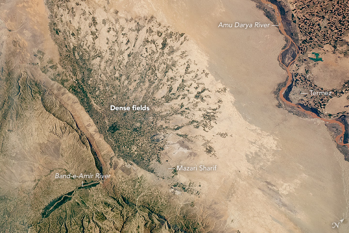
Koh e Alburz, Romanized as ''Kuh i Elburz'', ''Gory Koh-i-Elburz'', ''Kohe Alborz'', ''Kuh i Alborz'' ( prs, کوه البرز ''high mountain'') is a mountain a ridge of the Hindu Kush in Afghanistan, Balkh Province. The ridge is elongated to the south of the ancient city of Balkh, which is about 25 kilometers northwest from the city of Mazar-i-Sharif. It is a tertiary, elongated ridge with steep slopes to the north and south. The comb has short canyons. Between the breaking points are the small river ''Schadyan'' and Marmal mountain. The German ISAF troops call their nearby military camp Camp Marmal Camp Marmal was an installation of the Afghan Armed Forces. It was adjacent to Maulana Jalaluddin Balkhi International Airport in Mazar-i-Sharif, Afghanistan, at the foot of the Hindu Kush mountains. The camp was opened in September 2005. The ca .... {{Authority control One-thousanders of Afghanistan Landforms of Balkh Province ... [...More Info...] [...Related Items...] OR: [Wikipedia] [Google] [Baidu] |
Hindu Kush
The Hindu Kush is an mountain range in Central and South Asia to the west of the Himalayas. It stretches from central and western Afghanistan, Quote: "The Hindu Kush mountains run along the Afghan border with the North-West Frontier Province of Pakistan". into northwestern Pakistan and far southeastern Tajikistan. The range forms the western section of the ''Hindu Kush Himalayan Region'' (''HKH''); to the north, near its northeastern end, the Hindu Kush buttresses the Pamir Mountains near the point where the borders of China, Pakistan and Afghanistan meet, after which it runs southwest through Pakistan and into Afghanistan near their border. The eastern end of the Hindu Kush in the north merges with the Karakoram Range.Karakoram Range: MOUNTAINS, ASIA Encyclopædia Britannica Towards its s ... [...More Info...] [...Related Items...] OR: [Wikipedia] [Google] [Baidu] |
Balkh Province
Balkh (Dari: , ''Balx'') is one of the 34 provinces of Afghanistan, located in the north of the country. It is divided into 15 districts and has a population of about 1,509,183, which is multi-ethnic and mostly a Persian-speaking society. The city of Mazar-i-Sharif serves as the capital of the province. The Mazar-e Sharif International Airport and Camp Marmal sit on the eastern edge of Mazar-i-Sharif. Balkh, also called VazīrābādThename of the province is derived from the ancient city of Balkh, near the modern town. The city of Mazar-e-Sharif has been an important stop on the trade routes from the Far East to the Middle East, the Mediterranean and Europe. Home to the famous blue mosque, it was once destroyed by Genghis Khan but later rebuilt by Timur. The city of Balkh and the area of Balkh Province were considered a part of various historical regions in history including Ariana and Greater Khorasan. The province serves today as Afghanistan's second but main gateway to Ce ... [...More Info...] [...Related Items...] OR: [Wikipedia] [Google] [Baidu] |
Balkh
), named for its green-tiled ''Gonbad'' ( prs, گُنبَد, dome), in July 2001 , pushpin_map=Afghanistan#Bactria#West Asia , pushpin_relief=yes , pushpin_label_position=bottom , pushpin_mapsize=300 , pushpin_map_caption=Location in Afghanistan , subdivision_type=Country , subdivision_name= , subdivision_type1=Province , subdivision_name1=Balkh Province , subdivision_type2=District , subdivision_name2=Balkh District , population_as_of=2021 , population_footnotes= , population_blank1_title=City , population_blank1=138,594 , population_blank2_title=Religions , timezone=+ 4.30 , coordinates= , blank_name=Climate , blank_info=BSk Balkh (; prs, , ''Balkh''; xbc, Βάχλο, ''Bákhlo''; grc, Βάκτρα, ''Báktra'') is a town in the Balkh Province of Afghanistan, about northwest of the provincial capital, Mazar-e Sharif, and some south of the Amu Darya river and the Uzbekistan border. Its population was recently estimated to be 138,594. Balkh was historically an ancient pla ... [...More Info...] [...Related Items...] OR: [Wikipedia] [Google] [Baidu] |
Mazar-i-Sharif
, official_name = , settlement_type = City , image_skyline = , pushpin_map = Afghanistan#Bactria#West Asia , pushpin_label = Mazar-i-Sharif , pushpin_label_position = bottom , pushpin_mapsize = , pushpin_relief = yes , pushpin_map_caption = Location in Afghanistan , coordinates = , subdivision_type = Country , subdivision_name = Afghanistan , subdivision_type1 = Province , subdivision_type2 = District , subdivision_name1 = Balkh Province , subdivision_name2 = Mazar-i-Sharif District , established_title = , established_date = , leader_title = Mayor , leader_name = Abdullhaq Khurami , area_total_km2 = , area_land_km2 ... [...More Info...] [...Related Items...] OR: [Wikipedia] [Google] [Baidu] |
Camp Marmal
Camp Marmal was an installation of the Afghan Armed Forces. It was adjacent to Maulana Jalaluddin Balkhi International Airport in Mazar-i-Sharif, Afghanistan, at the foot of the Hindu Kush mountains. The camp was opened in September 2005. The camp gets its name from the bordering Marmal Mountains. Prior to the withdrawal of German troops, it was the largest base of the Bundeswehr outside Germany. Camp Marmal hosted the troops of Train Advise Assist Command – North belonging to the NATO Resolute Support Mission which succeeded the International Security Assistance Force in 2014. The base had a large medical center for the German forces, their NATO allies, and local civilians. The base supported German combat operations in Afghanistan in early 2009. History Germany began building the site on 3 November 2005 and became operational on 2 August 2006. In June 2021, the base was handed over to the Afghan Armed Forces and the last German troops left Afghanistan. On 15 August 2021, ... [...More Info...] [...Related Items...] OR: [Wikipedia] [Google] [Baidu] |


