|
Knowlesville, New Brunswick
Knowlesville is a small community in Carleton County in the Canadian province of New Brunswick. Knowlesville is in Aberdeen Parish, with a population in the 2011 Census of 981. It is located approximately 20 km east of Florenceville-Bristol, New Brunswick, along the Knowlesville Road. Mount Frederic Clark in Knowlesville has an elevation of 531 meters or 1742 feet. History Knowlesville is close to Skedaddle Ridge, where a number of Skedaddlers, draft evaders from the American Civil War lived during the 1860s. It was named for Rev. Charles Knowles, a Free Will Baptist minister from Yarmouth, Nova Scotia, who persuaded some local fishermen to take up farming in the area in 1861. Notable people * Earle Avery - Canadian & U.S. Hall of Fame harness racing driver/trainer. See also *List of communities in New Brunswick This is a list of communities in New Brunswick, a province in Canada. For the purposes of this list, a community is defined as either an incorporat ... [...More Info...] [...Related Items...] OR: [Wikipedia] [Google] [Baidu] |
Carleton County, New Brunswick
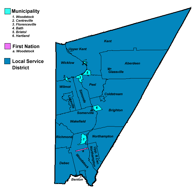
Carleton County (2016 population 26,220) is located in west-central New Brunswick, Canada. The western border is Aroostook County, Maine, Aroostook County, Maine, the northern border is Victoria County, New Brunswick, Victoria County, and the southeastern border is York County, New Brunswick, York County from which it was formed in 1831. The Saint John River (New Brunswick), Saint John River bisects the western section of the county. The Southwest Miramichi River flows through the eastern section of the county. Potato farming is a major industry. The scenic town of Hartland, New Brunswick, Hartland is home to the longest covered bridge in the world. Transportation Major Highways * * * * * * * * * * * * * * * * * * * * Census subdivisions List of communities in New Brunswick, Communities There are five incorporated municipalities within Carleton County (listed by 2016 population): First Nations There is one First Nations reserve in Carleton County, the Woodstock_First_Na ... [...More Info...] [...Related Items...] OR: [Wikipedia] [Google] [Baidu] |
Provinces And Territories Of Canada
Within the geographical areas of Canada, the ten provinces and three territories are sub-national administrative divisions under the jurisdiction of the Canadian Constitution. In the 1867 Canadian Confederation, three provinces of British North America—New Brunswick, Nova Scotia, and the Province of Canada (which upon Confederation was divided into Ontario and Quebec)—united to form a federation, becoming a fully independent country over the next century. Over its history, Canada's international borders have changed several times as it has added territories and provinces, making it the world's second-largest country by area. The major difference between a Canadian province and a territory is that provinces receive their power and authority from the ''Constitution Act, 1867'' (formerly called the ''British North America Act, 1867''), whereas territorial governments are creatures of statute with powers delegated to them by the Parliament of Canada. The powers flowing from t ... [...More Info...] [...Related Items...] OR: [Wikipedia] [Google] [Baidu] |
New Brunswick
New Brunswick (french: Nouveau-Brunswick, , locally ) is one of the thirteen provinces and territories of Canada. It is one of the three Maritime provinces and one of the four Atlantic provinces. It is the only province with both English and French as its official languages. New Brunswick is bordered by Quebec to the north, Nova Scotia to the east, the Gulf of Saint Lawrence to the northeast, the Bay of Fundy to the southeast, and the U.S. state of Maine to the west. New Brunswick is about 83% forested and its northern half is occupied by the Appalachians. The province's climate is continental with snowy winters and temperate summers. New Brunswick has a surface area of and 775,610 inhabitants (2021 census). Atypically for Canada, only about half of the population lives in urban areas. New Brunswick's largest cities are Moncton and Saint John, while its capital is Fredericton. In 1969, New Brunswick passed the Official Languages Act which began recognizing French as an ... [...More Info...] [...Related Items...] OR: [Wikipedia] [Google] [Baidu] |
Aberdeen Parish, New Brunswick
Aberdeen is a civil parish in Carleton County, New Brunswick, Canada, located in the interior east of the Saint John River. It comprises two local service districts (LSD), both of which are members of the Western Valley Regional Service Commission (WVRSC). The Census subdivision of Aberdeen Parish shares the civil parish's borders. Revised census figures based on the 2023 local governance reforms have not been released. Origin of name Aberdeen, Scotland was the source of many settlers of Glassville Settlement. Also possible is that the parish was named in honour of either the Earl of Aberdeen, a former Prime Minister of the United Kingdom who died shortly before Glassville was settled, or his youngest son Arthur Hamilton-Gordon, who was Lieutenant Governor of New Brunswick when the parish was erected. History Aberdeen was erected in 1863 from Brighton, Kent, and Peel Parishes. Most of the parish had formed the southeastern part of Kent, with Peel and Brighton providing a ... [...More Info...] [...Related Items...] OR: [Wikipedia] [Google] [Baidu] |
Florenceville-Bristol
Florenceville-Bristol is a town in the northwest part of Carleton County, New Brunswick, Canada. The town is located on the banks of the Saint John River. As of 2016, the population was 1,604. History Florenceville was originally known as Buttermilk Creek. In 1855 it was renamed Florenceville to honour Florence Nightingale, the famous Crimean War nurse. Florenceville was on the west side of the Saint John River and there the first post office and commercial section of the village was situated. In later years East Florenceville, previously known as Buckwheat Flats, became the commercial centre with five grocery stores and several other small businesses. There is a small strip mall along with several convenience stores and restaurants. The former village of ''Bristol'' is located on the Saint John River, in Carleton County, New Brunswick, Canada, approximately 5 kilometres north of Florenceville. It was named after the city of Bristol, England. The name replaced Kent Stat ... [...More Info...] [...Related Items...] OR: [Wikipedia] [Google] [Baidu] |
Mount Frederic Clark
Mount Frederick Clarke is a mountain located east of Knowlesville, New Brunswick. Name origin The mountain is named for Dr. George Frederick Clarke (1883-1974), a noted archaeologist, author and historian. The name was bestowed in July 1974. See also * List of mountains of New Brunswick References External links * https://web.archive.org/web/20120316110900/http://peakery.com/Mount-Frederick-Clarke/ * http://www.canmaps.com/topo/places/d/dafmh.htm Mountains of New Brunswick Landforms of Carleton County, New Brunswick Mountains of Canada under 1000 metres {{NewBrunswick-geo-stub ... [...More Info...] [...Related Items...] OR: [Wikipedia] [Google] [Baidu] |
Skedaddle Ridge, New Brunswick
''Skedaddle'' ( ) is a children's game show that aired in late 1988 for six weeks as a part of '' The Funtastic World of Hanna-Barbera'' block of shows. It was hosted by guest star Ron Pearson, and created by William Hanna and Joseph Barbera. The show was executive produced by Hanna and Barbera, along with Jay Wolpert Jay Wolpert (January 29, 1942 – January 3, 2022) was an American television producer and screenwriter. Life and career Wolpert was born in The Bronx, New York City. His first television appearance came as a contestant on the original version o ... for the autumn season being aired for eight months. Premise Six groups of two teams of four children (always the "Sludge Puppies" in red and the "Drainiacs" in yellow) each competed in a game similar to "Hot Potato" to answer questions and win prizes. The studio was set up to resemble a cartoonish sewer. Gameplay One team selected one of three costumed dinosaur characters (named Slam, Dunk, and Seymour, AKA: "Th ... [...More Info...] [...Related Items...] OR: [Wikipedia] [Google] [Baidu] |
Draft Evasion
Draft evasion is any successful attempt to elude a government-imposed obligation to serve in the military forces of one's nation. Sometimes draft evasion involves refusing to comply with the military draft laws of one's nation. Illegal draft evasion is said to have characterized every military conflict of the 20th and 21st centuries, in which at least one party of such conflict has enforced conscription. Such evasion is generally considered to be a criminal offense,Beare, Margaret E., ed. (2012). ''Encyclopedia of Transnational Crime and Justice''. Sage Publications, p. 110 ("Draft Dodging" entry). . and laws against it go back thousands of years. There are many draft evasion practices. Those that manage to adhere to or circumvent the law, and those that do not involve taking a public stand, are sometimes referred to as draft avoidance. Draft evaders are sometimes pejoratively referred to as draft dodgers,Bell, Walter F. "Draft Dodgers". In Tucker, Spencer C. (2013). ... [...More Info...] [...Related Items...] OR: [Wikipedia] [Google] [Baidu] |
American Civil War
The American Civil War (April 12, 1861 – May 26, 1865; also known by other names) was a civil war in the United States. It was fought between the Union ("the North") and the Confederacy ("the South"), the latter formed by states that had seceded. The central cause of the war was the dispute over whether slavery would be permitted to expand into the western territories, leading to more slave states, or be prevented from doing so, which was widely believed would place slavery on a course of ultimate extinction. Decades of political controversy over slavery were brought to a head by the victory in the 1860 U.S. presidential election of Abraham Lincoln, who opposed slavery's expansion into the west. An initial seven southern slave states responded to Lincoln's victory by seceding from the United States and, in 1861, forming the Confederacy. The Confederacy seized U.S. forts and other federal assets within their borders. Led by Confederate President Jefferson Davis, ... [...More Info...] [...Related Items...] OR: [Wikipedia] [Google] [Baidu] |
Free Will Baptist
Free Will Baptists are a group of General Baptist denominations of Christianity that teach free grace, free salvation and free will. The movement can be traced back to the 1600s with the development of General Baptism in England. Its formal establishment is widely linked to the English theologian, Thomas Helwys who led the Baptist movement to believe in general atonement. He was an advocate of religious liberty at a time when to hold to such views could be dangerous and punishable by death. He died in prison as a consequence of the religious persecution of Protestant dissenters under King James I. In 1702 Paul Palmer would go on to establish the movement in North Carolina and in 1727 formed the Free Will Baptist Church of Chowan. Many Calvinists became Free Will Baptists in the 19th century. With the establishment of Free Will Baptists in the South, Benjamin Randall developed the movement in the Northeastern United States, specifically Maine, Massachusetts, and New Hampshire ... [...More Info...] [...Related Items...] OR: [Wikipedia] [Google] [Baidu] |
Yarmouth, Nova Scotia
Yarmouth is a town in southwestern Nova Scotia, Canada. A port town, industries include fishing, and tourism. It is the terminus of a ferry service to Bar Harbor, Maine, run by Bay Ferries. History Originally inhabited by the Mi'kmaq, the region was known as "Keespongwitk" meaning "Lands End" due to its position at the tip of the Nova Scotia peninsula. European settlement The region was visited in 1604 by Samuel de Champlain, who named it "Cap-Fourchu", meaning "forked or cloven cape." The first Europeans to make a settlement on these shores were the French Acadians. They set up a small fishing settlement known as "Tebouque" in the mid 1600s and by 1750 the population was 50 people. During the Seven Years' War, New England Planters settled at what is now the town of Yarmouth in 1759; the grantees were from Yarmouth, Massachusetts and they requested that Yarmouth be named after their former home. Yarmouth was founded on June 9, 1761, when a ship carrying three families arrived fr ... [...More Info...] [...Related Items...] OR: [Wikipedia] [Google] [Baidu] |


