|
Kington Hundred
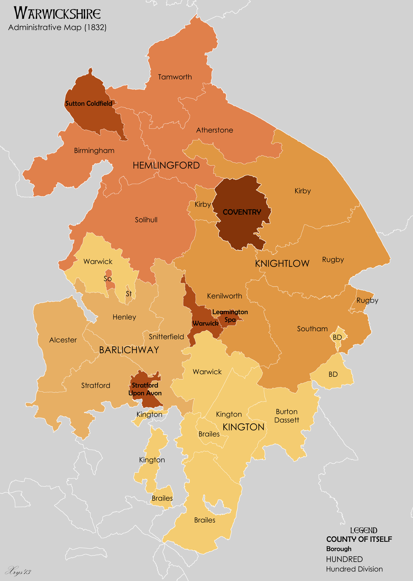
Kington or Kineton was a historic hundred of the county of Warwickshire in England. The hundred covered the southern part of the county, and lay south of Warwick, between the River Avon on the west and the River Itchen on the east. It was formed in the 12th century out of four Domesday hundreds, these were: ''Tremelau'', which contained the parishes of Atherstone-on-Stour, Barford, Butlers Marston, Chadshunt, Charlecote, Chesterton, Comberton, Compton Verney, Ettington, Gaydon, Halford, Lighthorne, Moreton Morrell, Newbold Pacey, the Pillertons, Tachbrook, and Wasperton. ''Honesberie'', containing Avon Dassett, Burton Dassett, Fenny Compton, Farnborough, part of Mollington, Priors Hardwick, Priors Marston, Radway, Ratley, Shotteswell, Warmington, and Wormleighton. ''Fexhole'', containing Brailes, Cherington, Compton Wynyates, Honington, Idlicote, Kineton, Lapworth, Oxhill, Packwood, Tanworth, Tysoe, Wellesbourne with Walton, and Whatcote. ''Berricestone'', or ''Barc ... [...More Info...] [...Related Items...] OR: [Wikipedia] [Google] [Baidu] |
Hundred (subdivision)
A hundred is an administrative division that is geographically part of a larger region. It was formerly used in England, Wales, some parts of the United States, Denmark, Southern Schleswig, Sweden, Finland, Norway, the Bishopric of Ösel–Wiek, Curonia, the Ukrainian state of the Cossack Hetmanate and in Cumberland County, New South Wales, Cumberland County in the British Colony of New South Wales. It is still used in other places, including in Australia (in South Australia and the Northern Territory). Other terms for the hundred in English and other languages include ''#wapentake, wapentake'', ''herred'' (Danish and Bokmål, Bokmål Norwegian), ''herad'' (Nynorsk, Nynorsk Norwegian), ''hérað'' (Icelandic), ''härad'' or ''hundare'' (Swedish), ''Harde'' (German), ''hiird'' (North Frisian language, North Frisian), ''satakunta'' or ''kihlakunta'' (Finnish), ''kihelkond'' (Estonian), ''kiligunda'' (Livonian), ''cantref'' (Welsh) and ''sotnia'' (Slavic). In Ireland, a similar subdi ... [...More Info...] [...Related Items...] OR: [Wikipedia] [Google] [Baidu] |
Moreton Morrell
Moreton Morrell is a village and civil parish in the county of Warwickshire, England. It is part of the historic hundred of Kington and is located about three and a half miles north west of the village of Kineton. The settlement was first mentioned in the Domesday Book as Moreton. From at least Norman times, it has consisted of the village of Moreton and the hamlet of Morrell. The parish of Moreton Morrell is bounded on the east and south east by the Fosse Way, and consists of Little Morrell in the north, the village of Moreton Morrell, and Moreton Paddox in the south. The population in 1801 was less than 200 and very similar to that cited in the Domesday Book in 1086. In the same year the advowson of the vill was divided between the lands of the Earl of Warwick and the Earl of Leicester to support their respective chapels, but by the 14th century the Hospital of St. John at Warwick received the revenues. By 1961 the population had doubled and by 2001 it had doubled again to 800 ... [...More Info...] [...Related Items...] OR: [Wikipedia] [Google] [Baidu] |
Warmington, Warwickshire
Warmington is a village and civil parish in the Stratford-on-Avon district of Warwickshire, England. It is located on the border with Oxfordshire, around 5 miles (8 km) northwest of Banbury. The civil parish had, according to the 2001 Census a population of 297 increasing to 304 at the 2011 Census. The parish also includes Arlescote and the council is calleWarmington & Arlescote The National Herb Centre is found just outside the village. Warmington is on the northern side of Edge Hill, a prominent local ridge. Its church is one of six that make up the Edgehill group, along with those of nearby Radway, Ratley and Shotteswell. The village is also regarded as being part of the informal area of Banburyshire. The M40 motorway passes just to the north and east of Warmington. Before the motorway was built, the village lay on the A41 road The A41 is a trunk road between London and Birkenhead, England. Now in parts replaced by motorways, it passes through or near Watfo ... [...More Info...] [...Related Items...] OR: [Wikipedia] [Google] [Baidu] |
Shotteswell
Shotteswell is a village and civil parish in the Stratford-on-Avon district of Warwickshire. The population of the civil parish at the 2011 census was 221. The parish is bounded on three sides by Oxfordshire and is about north-west of Banbury. Overview The name of the village has been spelt in various fashions over the centuries in a range of documents:- Sotteswalle around 1135, Shoteswell (1165), Schoteswell (1189), Schotewell (1190), Scoteswell (1221), Sotteswell (1235), Schetteswell (1315), Shotteswell (1428 and 1535), Shatswell (1705) as well as Cheleswell, Seteswell, Scacheswell and Shotswell, the latter in censuses of the mid-nineteenth century. It is said to derive from the Anglo-Saxon "Soto", a family name, and "will", a well – that is – "the well of Scot". In the past, an alternative explanation was put forward that the name derived from "sceota" or "scota" meaning the offshoot or brow of a hill – that is – the well at the brow of a hill. For a large part ... [...More Info...] [...Related Items...] OR: [Wikipedia] [Google] [Baidu] |
Ratley
Ratley is a village in the civil parish of Ratley and Upton, Stratford-on-Avon District, Warwickshire, England. The population of the civil parish in 2011 was 327. It is on the northwest side of the Edge Hill escarpment about above sea level. The village is close to the county border with north Oxfordshire, some 7 miles northwest of Banbury, the closest town. History of Ratley The remains of a 12th-century motte and bailey castle are just outside the village, which were designated a Scheduled monument in 1961. The Church of England parish church is Decorated Gothic and almost all of it was built in the 14th century. It is one of a few churches in England dedicated to St. Peter ad Vincula and is designated a Grade II* listed building. The Battle of Edge Hill, the first battle of the English Civil War, was fought very near the village. The former Church of England school and local Post Office buildings are still standing but have been converted into houses. Upton House is le ... [...More Info...] [...Related Items...] OR: [Wikipedia] [Google] [Baidu] |
Radway
Radway is a village and civil parish in Warwickshire, England, about north-west of Banbury in neighbouring Oxfordshire. The population taken at the 2011 census had reduced to 238. The village is at the foot of Edge Hill and is notable for the Battle of Edgehill, one of the early major engagements of the English Civil War, which was fought in fields around the village. History The earliest known record of Radway is in the Domesday Book of 1086.Salzman, 1949, pages 142-144 In medieval times its lands were divided between Arbury Priory and Stoneleigh Abbey. After the Dissolution of the Monasteries under Henry VIII in the 1530s the lands of Radway were granted to various of Henry's circle, notably the Coke family. As the lands were sold over the following years, the manorialism system of Radway broke down. The Battle of Edgehill, one of the early major engagements of the English Civil War, was fought in fields around the village and in the adjoining parishes of Ratley and Kine ... [...More Info...] [...Related Items...] OR: [Wikipedia] [Google] [Baidu] |
Priors Marston
Priors Marston is a village and civil parish in the Stratford-on-Avon District of Warwickshire, England, southwest of Daventry. The Oxford Canal and Jurassic Way both run nearby. According to the United Kingdom Census 2001, 2001 Census the population of the parish is 506, increasing to 579 at the United Kingdom Census 2011, 2011 Census, most of whom live in the village. In the village's Toponymy, toponym, "Prior (ecclesiastical), Priors" records the fact the village belonged to Coventry Cathedral#St Mary's Priory, St Mary's Priory in Coventry. "Marston" combines the Old English words ''Merse'' referring to a lake which formed a fishery in the early history of the village and ''tun'' meaning a settlement. The village has a primary school called The Priors School. The school was originally a state school, opened in 1847. However, in August 1996 the school was forced to close. After a month of intensive fundraising and planning the school re-opened, offering free education to village ... [...More Info...] [...Related Items...] OR: [Wikipedia] [Google] [Baidu] |
Priors Hardwick
Priors Hardwick is a village and civil parish in the Stratford district of Warwickshire, England. The population of the civil parish as taken at the 2011 census was 172. The name derives from the fact that it was originally a manor belonging to the Priors of Coventry. History The oldest houses in the village are centred on the village green, with The Butcher's Arms dated as 1562, although some sources place it back as far as 1375. The proximity to the drover's road known as the Welsh Road influenced the village and the naming of local landmarks. The cattle drovers used to water their animals at a pond outside the village, which resulted in it being named ''Cowpool''. This is unusual, since locally, such waterholes were named ''pits'', rather than the Welsh-derived name ''pool'' (pwyll). ''London End'' in the village, and various buildings with ''welsh'' in their name also derive from the closeness of the road. The original settlement is on the government's list of Schedul ... [...More Info...] [...Related Items...] OR: [Wikipedia] [Google] [Baidu] |
Mollington, Oxfordshire
Mollington is a village and civil parish about north of Banbury in Oxfordshire, England. The 2011 Census recorded the parish's population as 479. Toponym An Anglo-Saxon will from AD 1015 records the toponym as ''Mollintun'' and the Domesday Book of 1086 records it as ''Molitone'' and ''Mollitone''. An entry for 1220 in the Book of Fees records it as ''Mulinton'' and a pipe roll from 1230 records it in its modern form of ''Mollington''. It is derived from Old English, meaning the ''tūn'' of ''Moll''s people. Manor and governance Æthelstan Ætheling, eldest son of Æthelred the Unready willed an estate at Mollington to his father in 1014 or 1015. The ''Domesday Book'' records that by 1086 the manor was held by William d'Évreux, a kinsman of William the Conqueror. In 1086 Mollington was partly in three counties: Oxfordshire, Warwickshire and Northamptonshire. Later the village was only in Oxfordshire and Warwickshire, and in 1895 the Warwickshire part was transferred to O ... [...More Info...] [...Related Items...] OR: [Wikipedia] [Google] [Baidu] |
Farnborough, Warwickshire
Farnborough is a village and civil parish in the Stratford-on-Avon district of Warwickshire, England. It is located on the border with Oxfordshire, around 6 miles (10 km) north of Banbury. The population taken at the 2011 census was 265. The village has a church, St Botolphs, a village hall and an eating house, ''The Kitchen''. On the southern edge of the village is Farnborough Hall, a Grade I Listed building built by the Holbech family in the early 17th century and endowed to the National Trust in the 1960s. The interior of the Hall is most famous for its collection of Roman busts and paintings by Canaletto and Giovanni Paolo Panini collected during a Grand Tour by William Holbech junior in the early 18th century. The gardens and landscape were designed by the famous designer Sanderson Miller Sanderson Miller (1716 – 23 April 1780) was an English pioneer of Gothic revival architecture and landscape designer. He is noted for adding follies or other Picturesque ... [...More Info...] [...Related Items...] OR: [Wikipedia] [Google] [Baidu] |
Fenny Compton
Fenny Compton is a village and parish in Warwickshire, England, about eight miles north of Banbury. In the 2001 census the parish had a population of 797, increasing to 808 at the 2011 census. Its name comes from the Anglo-Saxon ''Fennig Cumbtūn'' meaning "marshy farmstead in a valley". In 1498 Sir William Cope, who served as Cofferer of the Household of Henry VII from 1494 to 1505 (in the absence at that time of a Treasurer of the Household he carried out the duties of that office as well), was granted the Lordships of Wormleighton and Fenny Compton, part of the lands of Simon de Montford who had been attainted in 1495. He later sold the lands to the Spencer family, later of Althorpe. The Parish church of St Peter and St. Clare was built in the 13th century and is a Grade II* listed building. The village has a doctor's consulting-room, a small Co-op Food store, a popular local pub located centrally and another pub on the outskirts. The old part of the village has many notab ... [...More Info...] [...Related Items...] OR: [Wikipedia] [Google] [Baidu] |
Burton Dassett
Burton Dassett is a parish and shrunken medieval village in the Stratford-upon-Avon district of Warwickshire, England. The population (including the village of Knightcote) of the civil parish at the 2011 census was 1,322. Much of the area is now in the Burton Dassett Hills country park. It was enclosed for sheep farming by Sir Edward Belknap and John Heritage at the end of the 15th century. It was the home of Sir Thomas Temple as a child, and for several generations was regarded by the Temple family of Stowe Buckinghamshire Buckinghamshire (), abbreviated Bucks, is a ceremonial county in South East England that borders Greater London to the south-east, Berkshire to the south, Oxfordshire to the west, Northamptonshire to the north, Bedfordshire to the north-ea ... as their ancestral home. There is a heraldic memorial to John Temple and his children in Burton Dassett church. Each of the twelve shields represents one of John Temple's children. The left half of each shi ... [...More Info...] [...Related Items...] OR: [Wikipedia] [Google] [Baidu] |

.jpg)


