|
Kimwarer
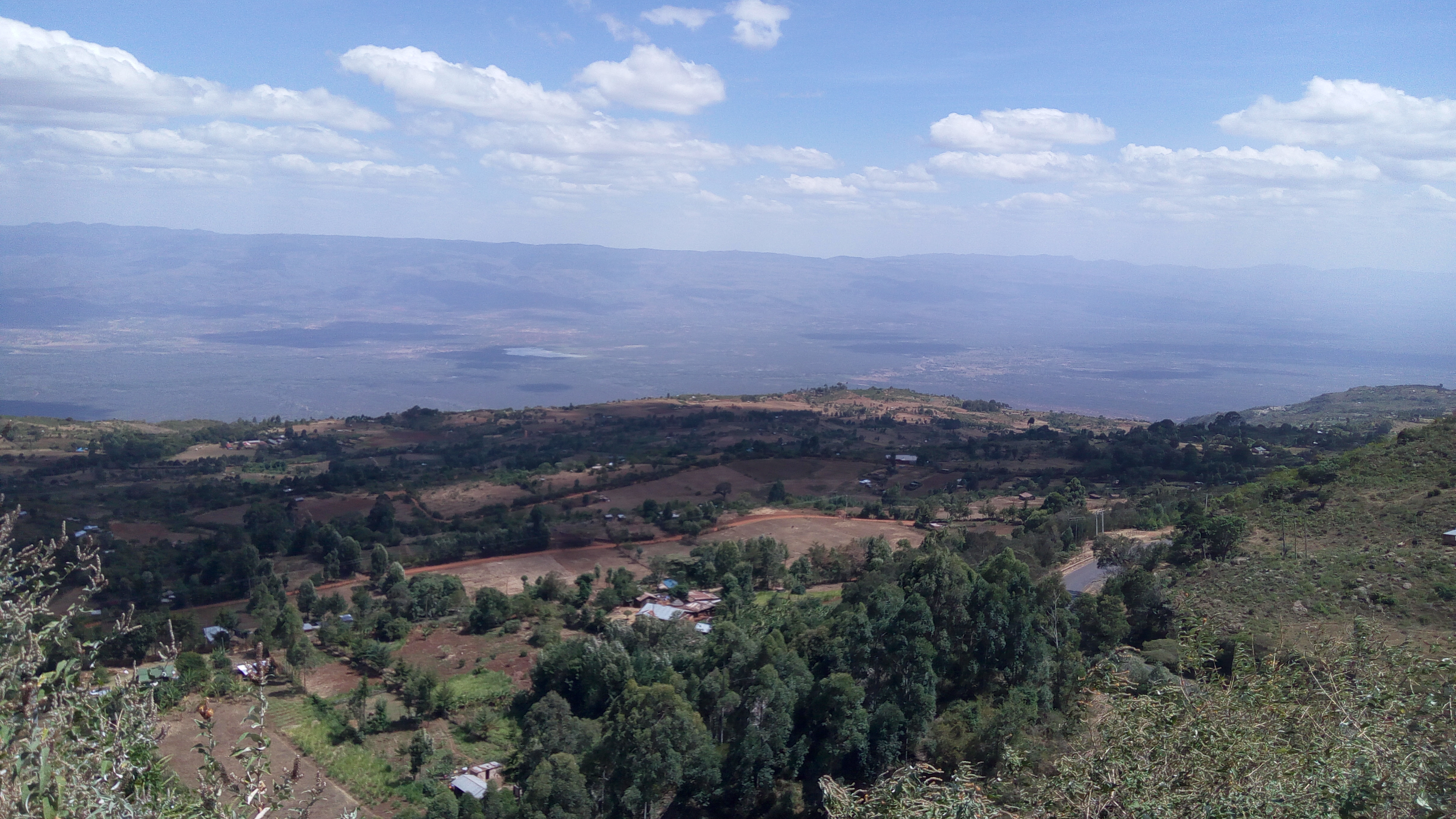
Kimwarer is a village in Elgeyo-Marakwet County, Kenya. It is located along the B54 Road between Eldoret and Tenges, in the southern part of Kerio Valley and in the drainage basin area of the Kerio River. One of the nearest villages is Kaptagat, located 10 kilometres west of Kimwarer on the Highlands. The nearest larger town, Eldoret, is 50 kilometres west of Kimwarer. Electorally Kimwarer is part of the Soy ward of Keiyo South Constituency and Keiyo County Council. It is the largest village in the Kerio Valley area. The main industry in the area is fluorspar mining, conducted by the Kenya Fluorspar Company.The East African, September 15, 2008Flourspar enters European market despite Chinese competition/ref> Kimwarer is effectively a mining town A mining community, also known as a mining town or a mining camp, is a community that houses miners. Mining communities are usually created around a mine or a quarry. Historic mining communities Australia * Ballarat, Victoria * ... [...More Info...] [...Related Items...] OR: [Wikipedia] [Google] [Baidu] |
Kenya Fluorspar Company
The Kenya Fluorspar Company is a privately held mining company in Kenya. It is located in Kimwarer, a village in the southern part of the Kerio Valley in Elgeyo-Marakwet County. History In 1967, fluorspar deposits were first discovered in the Kerio Valley, and the Kenyan government established the Fluorspar Company of Kenya to exploit them on a large scale. The company went into receivership in 1979, as Kenya Fluorspar, another government-owned company, bought the assets and took over operations. In 1996, Canadian businessman Charles Field-Marsham acquired Kenya Fluorspar as part of a government reform effort of corporate privatization, entering into a 20-year lease with the government for 3,664 hectares of land.. Kenya Fluorspar halted its mining operations in February 2009 due to an economic downturn, laying off 190 workers, but it resumed operations in June 2010. Operations were scaled down in June 2015, with the company laying off 75 workers and attempting to sell its ... [...More Info...] [...Related Items...] OR: [Wikipedia] [Google] [Baidu] |
Kerio Valley
Kerio Valley lies between the Tugen Hills and the Elgeyo Escarpment in Kenya. It sits at an elevation of 1,000 meters in the Great Rift Valley, Kenya, Great Rift Valley. Geography The isolated Kerio Valley is situated in a narrow, long strip that is approximately 80 km by 10 km wide at its broadest, through which the Kerio River flows. deep, the valley lies between the Cherangani Hills and the Tugen Hills The Tugen Hills (also known as ''Saimo'') are a series of hills in Baringo County, Kenya. They are located in the central-western portion of Kenya. The Tugen Hills represent one of the few areas in Africa preserving a succession of deposits from .... The Elgeyo Escarpment rises more than above it in places. It has semi-tropical vegetation on the slopes, while the floor of the valley is covered by dry thorn bush. The most comfortable time of the year is in July and August, when the rains have ended and the temperatures are not excessive. The Kerio Valley National ... [...More Info...] [...Related Items...] OR: [Wikipedia] [Google] [Baidu] |
Elgeyo-Marakwet County
Elgeyo-Marakwet County is one of Kenya's 47 counties. Elgeyo Marakwet County is located in the former Rift Valley Province. Its capital and largest town is Iten. It borders the counties of West Pokot to the north, Baringo County to the east, southeast and south, Uasin Gishu to the southwest and west, and Trans Nzoia to the northwest. Demographics The total population of Elgeyo-Marakwet County is 454,480 persons, of this 227,317 are females, 227,151 males and 12 intersex persons. There are 99,861 households in the county with an average size of 4.5 persons per household with a density population of 150 persons per square km. Geography, geology and topography The Kerio River binds the county on the eastern side. From its alluvial plain the topography gradually rises towards the west. The Elgeyo Escarpment stands out distinctly and causes elevation differences of up to 1,500 m. In the northern and southern part of the county the topography is rugged, giving way to more s ... [...More Info...] [...Related Items...] OR: [Wikipedia] [Google] [Baidu] |
Kenya
) , national_anthem = "Ee Mungu Nguvu Yetu"() , image_map = , map_caption = , image_map2 = , capital = Nairobi , coordinates = , largest_city = Nairobi , official_languages = Constitution (2009) Art. 7 ational, official and other languages"(1) The national language of the Republic is Swahili. (2) The official languages of the Republic are Swahili and English. (3) The State shall–-–- (a) promote and protect the diversity of language of the people of Kenya; and (b) promote the development and use of indigenous languages, Kenyan Sign language, Braille and other communication formats and technologies accessible to persons with disabilities." , languages_type = National language , languages = Swahili , ethnic_groups = , ethnic_groups_year = 2019 census , religion = , religion_year = 2019 census , demonym = ... [...More Info...] [...Related Items...] OR: [Wikipedia] [Google] [Baidu] |
Eldoret
Eldoret is a principal town in the Rift Valley region of Kenya and serves as the capital of Uasin Gishu County. The town was referred to by white settlers as Farm 64, 64 and colloquially by locals as 'Sisibo'. As per the 2019 Kenya Population and Housing Census, Eldoret is the fifth most populated urban area in the country after Kenya's 4 cities of Nairobi, Mombasa, Kisumu and Nakuru. Lying south of the Cherangani Hills, the local elevation varies from about at the airport to more than in nearby areas. The population was 289,380 in the 2009 Census, and it is currently the fastest growing town in Kenya with 475,716 people according to 2019 National Census. Eldoret was on course to be named Kenya's fourth city, but was edged out by Nakuru in 2021. Etymology The name "Eldoret" is based on the Maasai word "eldore" meaning "stony river"; a reference to the bed of the Sosiani River (a tributary of the Nile), that runs through the city. History Eldoret and the plateau around it h ... [...More Info...] [...Related Items...] OR: [Wikipedia] [Google] [Baidu] |
Drainage Basin
A drainage basin is an area of land where all flowing surface water converges to a single point, such as a river mouth, or flows into another body of water, such as a lake or ocean. A basin is separated from adjacent basins by a perimeter, the '' drainage divide'', made up of a succession of elevated features, such as ridges and hills. A basin may consist of smaller basins that merge at river confluences, forming a hierarchical pattern. Other terms for a drainage basin are catchment area, catchment basin, drainage area, river basin, water basin, and impluvium. In North America, they are commonly called a watershed, though in other English-speaking places, "watershed" is used only in its original sense, that of a drainage divide. In a closed drainage basin, or endorheic basin, the water converges to a single point inside the basin, known as a sink, which may be a permanent lake, a dry lake, or a point where surface water is lost underground. Drainage basins are similar ... [...More Info...] [...Related Items...] OR: [Wikipedia] [Google] [Baidu] |
Kerio River
The Kerio River is a river in Turkana County, Kenya. It flows northward into Lake Turkana. It is one of the longest rivers in Kenya, originating near the equator. Course The Kerio River rises on the north slopes of the Amasya Hills to the west of Lake Bogoria. It flows northward through the Kerio Valley between Tugen Hills and Elgeyo Escarpment. The Elgeyo Escarpment rises to over above the Kerio valley in places. The Kerio continues northward, often through deep and narrow valleys, to enter Lake Turkana in a delta just south of the delta formed by the Turkwel and Lokichar rivers. The Kerio and Turkwel contribute 98% of the river water flowing into Lake Turkana on Kenyan territory (which makes up only 2% of the total riverine inflow). In their lower courses both these rivers are seasonal. Near its source the Kerio River is fed by two major tributaries flowing down Elgeyo Escarpment: Arror River, and Embobut River. Land use The Lake Kamnarok National Reserve and Kerio Val ... [...More Info...] [...Related Items...] OR: [Wikipedia] [Google] [Baidu] |
Kaptagat
Kaptagat is a human settlement in Uasin Gishu County, in the southwestern part of Kenya. This part of the country, where the two counties of Uasin Gishu and Elgeyo Marakwet County share a border, is used by the majority of Kenyan professional long-distance runners to train for professional competition. Eliud Kipchoge, the marathon world record holder, who also doubles as the Tokyo Olympics and Rio Olympics marathon gold medalist, maintains a training camp in Kaptagat. Location Kaptagat is located in ''Kaptagat Ward'', ''Ainabkoi sub-county'', at the eastern edge of Uasin Gishu County. This is approximately by road, east of the city of Eldoret, along the B54 Road. This is approximately by road, northwest of the small town of Chepkorio, in neighboring Elgeyo Marakwet County, along the same B54 Road. Athletics training camps Kaptagat is home to the Great Rift Valley Sports Camp, a training camp for many Kenyan runners including Elijah Lagat, Eliud Kipchoge, Moses Tanui and ... [...More Info...] [...Related Items...] OR: [Wikipedia] [Google] [Baidu] |
Keiyo South Constituency
Keiyo South is an electoral constituency in Kenya. It is one of four constituencies of Elgeyo-Marakwet County. The constituency has 15 wards, all of which elect councillors for the Keiyo County Council. The constituency was established for the 1969 elections. It was one of two constituencies of the former Keiyo District Keiyo District (also known as ''Elgeyo district'' or Elgeiyo) is a defunct administrative district in the former Rift Valley Province of Kenya. The district was formed in 1994, when ''Elgeyo/Marakwet-District'' was split into two - the other half wa .... Members of Parliament Locations and wards References {{coord missing, Kenya Constituencies in Elgeyo-Marakwet County Constituencies in Rift Valley Province 1969 establishments in Kenya Constituencies established in 1969 ... [...More Info...] [...Related Items...] OR: [Wikipedia] [Google] [Baidu] |
Fluorspar
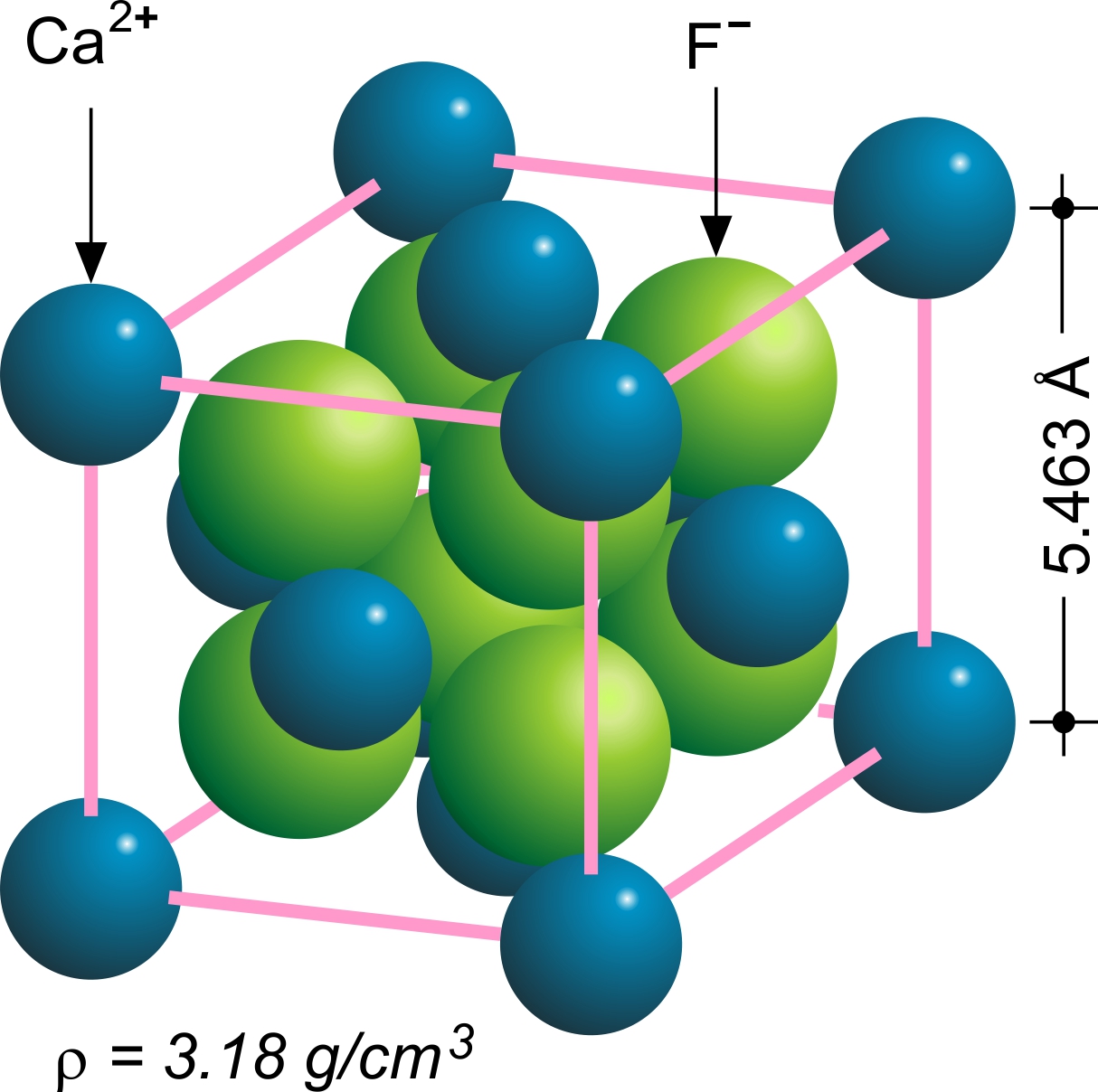
Fluorite (also called fluorspar) is the mineral form of calcium fluoride, CaF2. It belongs to the halide minerals. It crystallizes in isometric cubic habit, although octahedral and more complex isometric forms are not uncommon. The Mohs scale of mineral hardness, based on scratch hardness comparison, defines value 4 as fluorite. Pure fluorite is colourless and transparent, both in visible and ultraviolet light, but impurities usually make it a colorful mineral and the stone has ornamental and lapidary uses. Industrially, fluorite is used as a flux for smelting, and in the production of certain glasses and enamels. The purest grades of fluorite are a source of fluoride for hydrofluoric acid manufacture, which is the intermediate source of most fluorine-containing fine chemicals. Optically clear transparent fluorite lenses have low dispersion, so lenses made from it exhibit less chromatic aberration, making them valuable in microscopes and telescopes. Fluorite optics are also ... [...More Info...] [...Related Items...] OR: [Wikipedia] [Google] [Baidu] |
Mining Town
A mining community, also known as a mining town or a mining camp, is a community that houses miners. Mining communities are usually created around a mine or a quarry. Historic mining communities Australia * Ballarat, Victoria * Bendigo, Victoria Austria *Schwaz *Eisenerz, Styria Former Austria-Hungary Upper Austrio-Hungarian mining towns *Göllnitz, today Gelnica *Jossau, today Jasov *Nemecká Ľupča, today Partizánska Ľupča *Schmöllnitz, today Smolník *Rosenau, today Rožňava *Ruda, today Rudabánya in Hungary *Telken, today Telkibánya in Hungary *Zipser Neudorf, today Spišská Nová Ves Lower Austrio-Hungarian mining towns *Dilln, today Banská Belá *Königsberg, today Nová Baňa *Kremnitz, today Kremnica *Libethen, today Ľubietová *Neusohl, today Banská Bystrica *Pukanz, today Pukanec *Schemnitz, today Banská Štiavnica Bosnia and Herzegovina * Banovići * Kakanj *Tuzla *Zenica Canada * Cobalt, Ontario * Glace Bay, Nova Scotia *Dawson ... [...More Info...] [...Related Items...] OR: [Wikipedia] [Google] [Baidu] |


