|
Kimmage
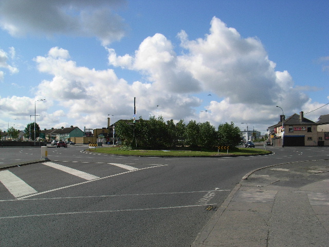
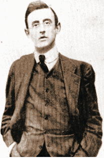
Kimmage ( or ''Camaigh uisce'', meaning "crooked water-meadow", possibly referring to the meandering course of the River Poddle), is a suburb on the south side of the city of Dublin in Ireland. Location Kimmage is to the south of Dublin city centre, outside the ring of canals, but before the M50 ring motorway or the Dublin mountains. It is surrounded by Crumlin, Greenhills, Harold's Cross, Rathfarnham, Templeogue and Terenure. Kimmage is divided between postal districts Dublin 12 and Dublin 6W. History Larkfield, an old mill and farm in Kimmage owned by the family of Joseph Plunkett, was used as a clearing station for arms imported in the 1914 Howth gun-running for use in the 1916 Easter Rising. An Irish Volunteers secret camp, the Kimmage Garrison, was established by Plunkett and his brother George Oliver Plunkett. IRB members with engineering skills came from England and Scotland and lived rough for three months while they manufactured bombs, bayonets and pikes for the com ... [...More Info...] [...Related Items...] OR: [Wikipedia] [Google] [Baidu] |
River Poddle
The River Poddle ( ga, An Poitéal) is a river in Dublin, Ireland, a pool which (', "black pool" or "dark pool" in Irish) gave the city its English language name. Boosted by a channel made by the Abbey of St. Thomas à Becket, taking water from the far larger River Dodder, the Poddle was the main source of drinking water for the city for more than 500 years, from the 1240s. The Poddle, which flows wholly within the traditional County Dublin, is one of around a hundred members of the River Liffey system (excluding the Dodder tributaries), and one of over 135 watercourses in the county; it has just one significant natural tributary, the Commons Water from Crumlin. The Poddle rises in the southwest of County Dublin, in the Cookstown area, northwest of Tallaght, in the county of South Dublin, and flows into the River Liffey at Wellington Quay in central Dublin. Flowing in the open almost to the Grand Canal at Harold's Cross, its lower reaches, including multiple connected artifi ... [...More Info...] [...Related Items...] OR: [Wikipedia] [Google] [Baidu] |
Templeogue
Templeogue () is a southwestern suburb of Dublin in Ireland. It lies between the River Poddle and River Dodder, and is about halfway from Dublin's centre to the mountains to the south. Geography Location The centre of Templeogue is from both the city centre to the north and the Dublin Mountains to the south, and to the coast at Dublin Bay on the Irish Sea. It is above sea level and occupies an area of 534 hectares. Suburbs adjacent to Templeogue are Ballyboden, Ballyroan, Firhouse, Greenhills, Kimmage, Knocklyon, Perrystown, Rathfarnham, Tallaght, and Terenure. Transport The three main routes through the suburb are the R112 regional road (Templeville Road), the R137 regional road (Templeogue Road), and the R817 regional road (Cypress Grove Road and Wainsfort Road). Dublin Bus operates the following bus routes through Templeogue: 15, 15A, 15B, 15D, 49, 54A, 65, 65B and 150. Natural features The River Dodder forms the southern border with Rathfarnham while the ... [...More Info...] [...Related Items...] OR: [Wikipedia] [Google] [Baidu] |
Crumlin, Dublin
Crumlin () is a Southside suburb of Dublin, Ireland. Formerly a rural area, it became heavily built up from the early 20th century onwards. Crumlin is the site of Ireland's largest children's hospital, Our Lady's Children's Hospital. Location Crumlin covers the area from the River Poddle near the KCR (Kimmage Cross Roads) to Sundrive Road and Crumlin Cross at ''The Submarine Bar'' to Crumlin's village core and the Drimnagh Road, to Bunting Road, Crumlin Road then along the Grand Canal from Rialto Bridge to Sally's Bridge. It is situated near to the city centre, on the Southside of Dublin city. Neighbouring areas include Walkinstown, Perrystown, Drimnagh, Terenure, and Kimmage. Crumlin is contained within postal district Dublin 12. Name Crumlin gets its name from the "crooked valley" known as Lansdowne Valley. The valley was formed by glacial erosion in the distant past and is now bisected by the River Camac. The valley is situated in front of Drimnagh and is largely made up of ... [...More Info...] [...Related Items...] OR: [Wikipedia] [Google] [Baidu] |
Dublin 6W
Dublin postal districts have been used by Ireland's postal service, known as ''An Post'', to sort mail in Dublin. The system is similar to that used in cities in Europe and North America until they adopted national postal code systems in the 1960s and 1970s. These were incorporated into a new national postcode system, known as Eircode, which was implemented in 2015. Under the Eircode system, the city is covered by the original routing areas D01 to D24, along with A## and K## codes for locations elsewhere in County Dublin. History The postal district system was introduced in 1917 by the British government, as a practical way to organise local postal distribution. This followed the example of other cities, including London, first subdivided into ten districts in 1857, and Liverpool, the first city in Britain or Ireland to have postcodes, from 1864. The letter "D" was assigned to designate Dublin. The new Irish government retained the postal district system, but district numbers ... [...More Info...] [...Related Items...] OR: [Wikipedia] [Google] [Baidu] |
George Oliver Plunkett
George Oliver Plunkett (; 5 July 1894 – 21 January 1944), known to his contemporaries as Seoirse Plunkett,p94, Ernie O'Malley, ''The Singing Flame'', Anvil Books Limited, 1978 was a militant Irish republican. He was sentenced to death with his elder brother Joseph Plunkett and his younger brother John after the 1916 Easter Rising, but George's and John's sentences were commuted. He was released in 1917, fought in the Irish War of Independence and Irish Civil War, and was briefly IRA Chief of Staff during World War II. Early life Seoirse was born in 1894, in Dublin, where his parents lived at the time, the son of George Noble Plunkett, a papal count and curator of the National Museum and his wife, Josephine, née Cranny; the Plunkett and Cranny families were both housing developers. George was named after his father and his collateral ancestor Oliver Plunkett, Archbishop of Armagh, who was martyred in 1681. He was one of seven children; his siblings were Philomena (Mimi, ... [...More Info...] [...Related Items...] OR: [Wikipedia] [Google] [Baidu] |
Terenure
Terenure (), originally called ''Roundtown'', is an affluent, middle class suburb of Dublin in Ireland. It is located in the city's D6W postcode area. Location and transport Terenure lies primarily in the administrative area of Dublin City Council but with parts falling in South Dublin. It is located south of Harold's Cross and north of Rathfarnham, and also borders the suburbs of Templeogue, Rathgar, Kimmage and Perrystown. ''Terenure Cross'' (Vaughan's Corner) was at one time a terminus for the Dublin tramways, and is mentioned in James Joyce's novel ''Ulysses'' (Episode 7, 'Aeolus'). There were three tram depots in Terenure at one time, the main tram depot for the number 15 Dublin United Transport Company (DUTC) trams on Terenure Road East, another DUTC depot for number 16 trams on Rathfarnham Road, and the terminus of the Dublin and Blessington Steam Tramway on Templeogue Road. The modern tram system — the Luas — does not serve Terenure, but it is still served by bu ... [...More Info...] [...Related Items...] OR: [Wikipedia] [Google] [Baidu] |
Harold's Cross
Harold's Cross () is an affluent urban village and inner suburb on the south side of Dublin, Ireland in the postal district D6W. The River Poddle runs through it, though largely in an underground culvert, and it holds a major cemetery, Mount Jerome, and Our Lady's Hospice. Location Harold's Cross is situated north of Terenure and Rathgar, west of Rathmines, east of Crumlin and Kimmage, and directly south from the Grand Canal at Clanbrassil Street. It lies within the jurisdiction of Dublin City Council, and straddles the boundary of Dublin 6, Dublin 6W and Dublin 12 postal districts. The Poddle The River Poddle runs south to north through the area. At the southern end of the district, the river's course splits at the centuries-old "Tongue" or "Stone Boat" with part of its flow diverted underground into the "City Watercourse" culvert, while the mainline continues overground, passing through ponds. The Poddle goes underground between Mount Argus and Mount Jerome, then flo ... [...More Info...] [...Related Items...] OR: [Wikipedia] [Google] [Baidu] |
Greenhills, Dublin
Greenhills () is a suburb of Dublin in Ireland. It lies between Kimmage, Tallaght, Ballymount, Templeogue, Terenure and Walkinstown, which the area of Greenhills was historically part of, and includes a number of residential developments. A number of roads in the Greenhills area are named after saints, including Saint Peter's Road ( R112 regional road), Saint James Road, Saint Joseph's Road and Saint Patrick's Road. Greenhills is in the Dublin 12 postal area of County Dublin and is in the jurisdiction of South Dublin County Council. Name and history The area's name comes from the sand-based hills that made up a glacial esker which formed in the area at the end of the Ice Age. Greenhills may have housed settlements since at least the Bronze Age, as an urn dating from that time was found in the area in the late 1890s. Discovered in a former quarry between the Greenhills Road and St. Columba's Road, this urn is now held by the National Museum of Ireland. However, the area was mos ... [...More Info...] [...Related Items...] OR: [Wikipedia] [Google] [Baidu] |
Dublin 12
Dublin postal districts have been used by Ireland's postal service, known as '' An Post'', to sort mail in Dublin. The system is similar to that used in cities in Europe and North America until they adopted national postal code systems in the 1960s and 1970s. These were incorporated into a new national postcode system, known as Eircode, which was implemented in 2015. Under the Eircode system, the city is covered by the original routing areas D01 to D24, along with A## and K## codes for locations elsewhere in County Dublin. History The postal district system was introduced in 1917 by the British government, as a practical way to organise local postal distribution. This followed the example of other cities, including London, first subdivided into ten districts in 1857, and Liverpool, the first city in Britain or Ireland to have postcodes, from 1864. The letter "D" was assigned to designate Dublin. The new Irish government retained the postal district system, but district number ... [...More Info...] [...Related Items...] OR: [Wikipedia] [Google] [Baidu] |
Easter Rising
The Easter Rising ( ga, Éirí Amach na Cásca), also known as the Easter Rebellion, was an armed insurrection in Ireland during Easter Week in April 1916. The Rising was launched by Irish republicans against British rule in Ireland with the aim of establishing an independent Irish Republic while the United Kingdom was fighting the First World War. It was the most significant uprising in Ireland since the rebellion of 1798 and the first armed conflict of the Irish revolutionary period. Sixteen of the Rising's leaders were executed from May 1916. The nature of the executions, and subsequent political developments, ultimately contributed to an increase in popular support for Irish independence. Organised by a seven-man Military Council of the Irish Republican Brotherhood, the Rising began on Easter Monday, 24 April 1916 and lasted for six days. Members of the Irish Volunteers, led by schoolmaster and Irish language activist Patrick Pearse, joined by the smaller Irish Citizen Arm ... [...More Info...] [...Related Items...] OR: [Wikipedia] [Google] [Baidu] |
Rathfarnham
Rathfarnham () is a Southside suburb of Dublin, Ireland. It is south of Terenure, east of Templeogue, and is in the postal districts of Dublin 14 and 16. It is within the administrative areas of both Dún Laoghaire–Rathdown County Council and South Dublin County Council. Located within the historical baronies of Rathdown and Uppercross, Rathfarnham village originally developed around a fortification overlooking a ford on the River Dodder. From the medieval period, Rathfarnham was on the perimeter of the Pale (the area of Anglo-Norman influence in Ireland, centred on Dublin), and a number of defensive structures were built in the area. Rathfarnham Castle, a fortified house, was built in the late 16th century. Developed around these structures, by the 19th century there were a number of mills operating in the area, and Rathfarnham was still somewhat rural by the early 20th century. During the 20th century, with the expansion of metropolitan Dublin, Rathfarnham became a lar ... [...More Info...] [...Related Items...] OR: [Wikipedia] [Google] [Baidu] |
Joseph Plunkett
Joseph Mary Plunkett (Irish: ''Seosamh Máire Pluincéid''; 21 November 1887 – 4 May 1916) was an Irish nationalist, republican, poet, journalist, revolutionary and a leader of the 1916 Easter Rising. Joseph Mary Plunkett married Grace Gifford in 1916, seven hours before his execution. Background Plunkett was born at 26 Upper Fitzwilliam Street in one of Dublin's most affluent districts. Both his parents came from wealthy backgrounds, and his father, George Noble Plunkett, had been made a papal count. Plunkett contracted tuberculosis (TB) at a young age and spent part of his youth in the warmer climates of the Mediterranean and North Africa. He spent time in Algiers where he studied Arabic literature and language and composed poetry in Arabic. He was educated at the Catholic University School (CUS) and by the Jesuits at Belvedere College in Dublin and later at Stonyhurst College, in Lancashire, England where he acquired some military knowledge from the Officers' Training Co ... [...More Info...] [...Related Items...] OR: [Wikipedia] [Google] [Baidu] |

%2C_M50_in_background_(geograph_3545710).jpg)


.jpg)
