|
Kilpatrick Hills
The Kilpatrick Hills are a range of hills in central Scotland, stretching from Dumbarton in the west to Strathblane in the east. Strathblane divides the Kilpatricks from the Campsie Fells to the east, while to the north is part of the Loch Lomond and the Trossachs National Park. To west and south the hills are fringed by the settlements of Balloch, Dumbarton, Milton, Bowling, Old Kilpatrick, Clydebank, Bearsden and Milngavie. The majority of the range is within West Dunbartonshire, although it extends into the East Dunbartonshire and Stirling areas. The highest points in the range are Duncolm () and Fynloch (). The Kilpatricks offer a number of viewpoints and places of interest: among the best known are Doughnot Hill and The Whangie. The area features several reservoirs. The hills are of volcanic origin, modified by subsequent glaciation. Geology The Kilpatrick Hills are a part of the Clyde Plateau Lavas. These are about 340 million years old. Basaltic types of rocks (l ... [...More Info...] [...Related Items...] OR: [Wikipedia] [Google] [Baidu] |
Duncolm
Duncolm (Scottish Gaelic: Dùn Choluim) is a hill in Scotland. It is the highest point in both West Dunbartonshire and the Kilpatrick Hills, at an elevation of . Its name means "Fort of Columba". It lies near Loch Humphrey. There is an easy path to the summit from the south-west, which passes over two subsidiary peaks, Little Duncolm and Middle Duncolm. External links short article References Marilyns of Scotland Mountains and hills of West Dunbartonshire {{scotland-geo-stub ... [...More Info...] [...Related Items...] OR: [Wikipedia] [Google] [Baidu] |
East Dunbartonshire
East Dunbartonshire ( sco, Aest Dunbartanshire; gd, Siorrachd Dhùn Bhreatainn an Ear) is one of the 32 council areas of Scotland. It borders the north of Glasgow and contains many of the affluent areas to the north of the city, including Bearsden, Milngavie, Milton Of Campsie, Balmore and Torrance, as well as many of the city's commuter towns and villages. East Dunbartonshire also shares borders with North Lanarkshire, Stirling and West Dunbartonshire. The council area covers parts of the historic counties of Dunbartonshire, Lanarkshire and Stirlingshire. The council area was formed in 1996, as a result of the Local Government etc. (Scotland) Act 1994, from the former Bearsden and Milngavie district and most of the former Strathkelvin district (all areas except Chryston and Auchinloch, which became part of North Lanarkshire council area), within the wider Strathclyde region. Demographics East Dunbartonshire council area has low levels of deprivation, with relatively low u ... [...More Info...] [...Related Items...] OR: [Wikipedia] [Google] [Baidu] |
Cup And Ring Mark
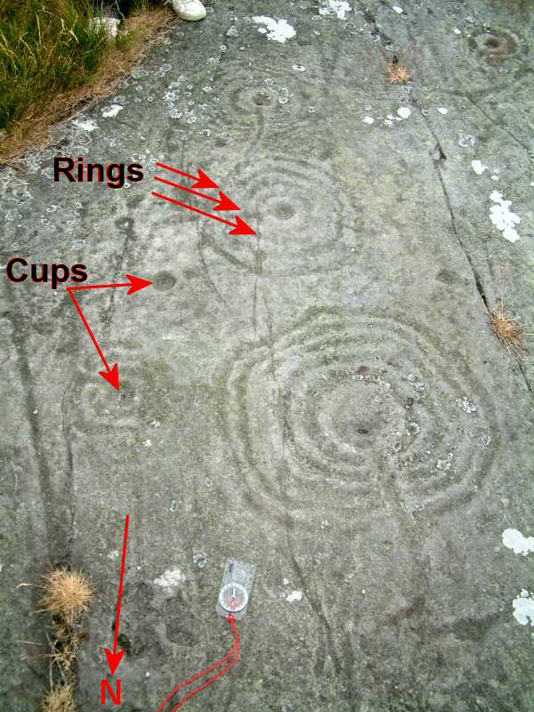
Cup and ring marks or cup marks are a form of prehistoric art found in the Atlantic seaboard of Europe (Ireland, Wales, Northern England, Scotland, France (Brittany), Portugal, and Spain ( Galicia) – and in Mediterranean Europe – Italy (in Alpine valleys and Sardinia), Azerbaijan and Greece (Thessaly and Irakleia (Cyclades)), as well as in Scandinavia (Denmark, Sweden, Norway and Finland) and in Switzerland (at Caschenna in Grisons). Similar forms are also found throughout the world including Australia, Gabon, Greece, Hawaii, India ( Daraki-Chattan), Israel, Mexico, Mozambique and the Americas. The oldest known forms are found from the Fertile Crescent to India. They consist of a concave depression, no more than a few centimetres across, pecked into a rock surface and often surrounded by concentric circles also etched into the stone. Sometimes a linear channel called a gutter leads out from the middle. The decoration occurs as a petroglyph on natural boulders and outcrop ... [...More Info...] [...Related Items...] OR: [Wikipedia] [Google] [Baidu] |
Cist
A cist ( or ; also kist ; from grc-gre, κίστη, Middle Welsh ''Kist'' or Germanic ''Kiste'') is a small stone-built coffin-like box or ossuary used to hold the bodies of the dead. Examples can be found across Europe and in the Middle East. A cist may have been associated with other monuments, perhaps under a cairn or long barrow. Several cists are sometimes found close together within the same cairn or barrow. Often ornaments have been found within an excavated cist, indicating the wealth or prominence of the interred individual. This old word is preserved in the Nordic languages as "" in Swedish and "" in Danish and Norwegian, where it is the word for a funerary coffin. In English it is related to "cistern".''cistern'' Regional examples ;Sri Lanka * Bellanbedipalassa * Pothana * Ibbankatuwa Megalithic Stones * Udaranchamadama ;England * Bellever Forest, Dartmoor * Hepburn woods, Northumberland ;Estonia * Jõelähtme (Rebala) stone-cist graves, Harju County ;Gu ... [...More Info...] [...Related Items...] OR: [Wikipedia] [Google] [Baidu] |
Bronze Age
The Bronze Age is a historic period, lasting approximately from 3300 BC to 1200 BC, characterized by the use of bronze, the presence of writing in some areas, and other early features of urban civilization. The Bronze Age is the second principal period of the three-age system proposed in 1836 by Christian Jürgensen Thomsen for classifying and studying ancient societies and history. An ancient civilization is deemed to be part of the Bronze Age because it either produced bronze by smelting its own copper and alloying it with tin, arsenic, or other metals, or traded other items for bronze from production areas elsewhere. Bronze is harder and more durable than the other metals available at the time, allowing Bronze Age civilizations to gain a technological advantage. While terrestrial iron is naturally abundant, the higher temperature required for smelting, , in addition to the greater difficulty of working with the metal, placed it out of reach of common use until the end o ... [...More Info...] [...Related Items...] OR: [Wikipedia] [Google] [Baidu] |
Chambered Cairn
A chambered cairn is a burial monument, usually constructed during the Neolithic, consisting of a sizeable (usually stone) chamber around and over which a cairn of stones was constructed. Some chambered cairns are also passage-graves. They are found throughout Britain and Ireland, with the largest number in Scotland. Typically, the chamber is larger than a cist, and will contain a larger number of interments, which are either excarnated bones or inhumations (cremations). Most were situated near a settlement, and served as that community's "graveyard". Scotland Background During the early Neolithic (4000–3300 BC) architectural forms are highly regionalised with timber and earth monuments predominating in the east and stone-chambered cairns in the west. During the later Neolithic (3300–2500 BC) massive circular enclosures and the use of grooved ware and Unstan ware pottery emerge. Scotland has a particularly large number of chambered cairns; they are found in various differe ... [...More Info...] [...Related Items...] OR: [Wikipedia] [Google] [Baidu] |
Scots Language
Scots ( endonym: ''Scots''; gd, Albais, ) is an Anglic language variety in the West Germanic language family, spoken in Scotland and parts of Ulster in the north of Ireland (where the local dialect is known as Ulster Scots). Most commonly spoken in the Scottish Lowlands, Northern Isles and northern Ulster, it is sometimes called Lowland Scots or Broad Scots to distinguish it from Scottish Gaelic, the Goidelic Celtic language that was historically restricted to most of the Scottish Highlands, the Hebrides and Galloway after the 16th century. Modern Scots is a sister language of Modern English, as the two diverged independently from the same source: Early Middle English (1150–1300). Scots is recognised as an indigenous language of Scotland, a regional or minority language of Europe, as well as a vulnerable language by UNESCO. In the 2011 United Kingdom census, 2011 Scottish Census, over 1.5 million people in Scotland reported being able to speak Scots. As there are ... [...More Info...] [...Related Items...] OR: [Wikipedia] [Google] [Baidu] |
Landslide Classification
There have been known various classifications of landslides. Broad definitions include forms of mass movement (geology), mass movement that narrower definitions exclude. For example, the ''McGraw-Hill Encyclopedia of Science and Technology'' distinguishes the following types of landslides: *fall (by undercutting) *fall (by toppling) *Slump (geology), slump *rockslide *earthflow *sinkholes, mountain side *rockslide that develops into rock avalanche Influential narrower definitions restrict landslides to slumps and translational slides in rock and regolith, not involving fluidisation. This excludes falls, topples, lateral spreads, and mass flows from the definition.Varnes D. J., Slope movement types and processes. In: Schuster R. L. & Krizek R. J. Ed., Landslides, analysis and control. Transportation Research Board Sp. Rep. No. 176, Nat. Acad. oi Sciences, pp. 11–33, 1978.Hungr O, Evans SG, Bovis M, and Hutchinson JN (2001) Review of the classification of landslides of the flow type ... [...More Info...] [...Related Items...] OR: [Wikipedia] [Google] [Baidu] |
Plucking (glaciation)
Plucking, also referred to as ''quarrying'', is a glacial phenomenon that is responsible for the weathering and erosion of pieces of bedrock, especially large "joint blocks". This occurs in a type of glacier called a "valley glacier". As a glacier moves down a valley, friction causes the basal ice of the glacier to melt and infiltrate joints (cracks) in the bedrock. The freezing and thawing action of the ice enlarges, widens, or causes further cracks in the bedrock as it changes volume across the ice/water phase transition (a form of hydraulic wedging), gradually loosening the rock between the joints. This produces large pieces of rock called joint blocks. Eventually these joint blocks come loose and become trapped in the glacier. In this way, plucking has been linked to regelation. Rocks of all sizes can become trapped in the bottom of the glacier. Joint blocks up to three meters have been "plucked" and transported. These entrained rock fragments can also cause abrasion along ... [...More Info...] [...Related Items...] OR: [Wikipedia] [Google] [Baidu] |
Agglomerate
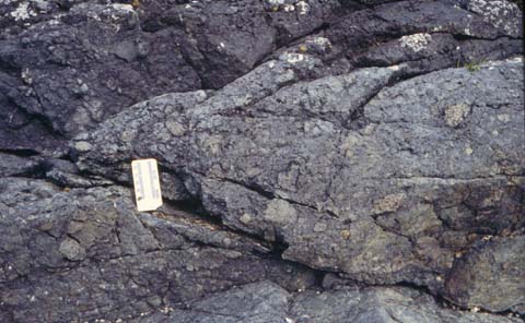
Agglomerate (from the Latin ''agglomerare'' meaning "to form into a ball") is a coarse accumulation of large blocks of volcanic material that contains at least 75% bombs. Volcanic bombs differ from volcanic blocks in that their shape records fluidal surfaces: they may, for example, have ropy, cauliform, scoriaceous, folded, spindle, spatter, ribbon, ragged, or amoeboid shapes. Globular masses of lava may have been shot from the crater at a time when partly molten lava was exposed, and was frequently shattered by sudden outbursts of steam. These bombs were viscous at the moment of ejection and by rotation in the air acquired their shape. They are commonly in diameter, but specimens as large as have been observed. There is less variety in their composition at any one volcanic centre than in the case of the lithic blocks, and their composition indicates the type of magma being erupted. Agglomerates are typically found near volcanic vents and within volcanic conduits, where they m ... [...More Info...] [...Related Items...] OR: [Wikipedia] [Google] [Baidu] |
Tuff
Tuff is a type of rock made of volcanic ash ejected from a vent during a volcanic eruption. Following ejection and deposition, the ash is lithified into a solid rock. Rock that contains greater than 75% ash is considered tuff, while rock containing 25% to 75% ash is described as tuffaceous (for example, ''tuffaceous sandstone''). Tuff composed of sandy volcanic material can be referred to as volcanic sandstone. Tuff is a relatively soft rock, so it has been used for construction since ancient times. Because it is common in Italy, the Romans used it often for construction. The Rapa Nui people used it to make most of the ''moai'' statues on Easter Island. Tuff can be classified as either igneous or sedimentary rock. It is usually studied in the context of igneous petrology, although it is sometimes described using sedimentological terms. Tuff is often erroneously called tufa in guidebooks and in television programmes. Volcanic ash The material that is expelled in a volcanic ... [...More Info...] [...Related Items...] OR: [Wikipedia] [Google] [Baidu] |
Lava
Lava is molten or partially molten rock (magma) that has been expelled from the interior of a terrestrial planet (such as Earth) or a moon onto its surface. Lava may be erupted at a volcano or through a fracture in the crust, on land or underwater, usually at temperatures from . The volcanic rock resulting from subsequent cooling is also often called ''lava''. A lava flow is an outpouring of lava during an effusive eruption. (An explosive eruption, by contrast, produces a mixture of volcanic ash and other fragments called tephra, not lava flows.) The viscosity of most lava is about that of ketchup, roughly 10,000 to 100,000 times that of water. Even so, lava can flow great distances before cooling causes it to solidify, because lava exposed to air quickly develops a solid crust that insulates the remaining liquid lava, helping to keep it hot and inviscid enough to continue flowing. The word ''lava'' comes from Italian and is probably derived from the Latin word ''labes ... [...More Info...] [...Related Items...] OR: [Wikipedia] [Google] [Baidu] |


