|
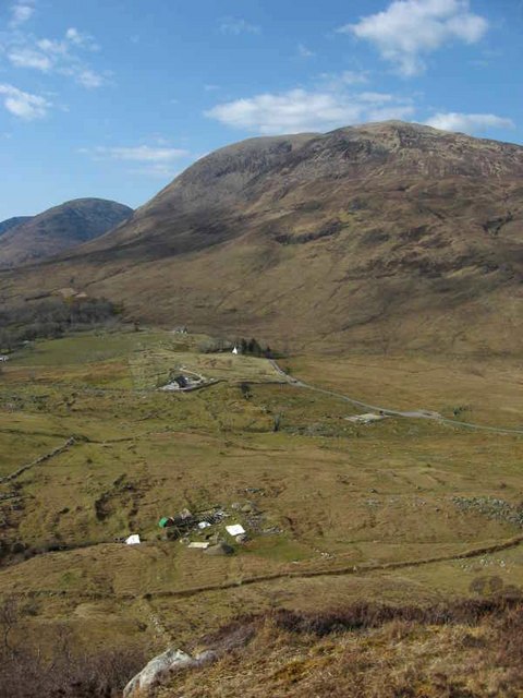
Kilbride, Skye
Kilbride (Scottish Gaelic: ''Cille Bhrìghde'', or the Church of Saint Bride) is a small township in Strath Swordale, Isle of Skye, Scotland. The township is situated in a pocket of fertile lime-rich soil, between the Red Hills to the north and Beinn an Dubhaich and the Suidhisnis peninsula to the south. It has been inhabited since ancient times; there is a standing stone (Clach na h-Annait), the site of an ancient chapel (or ''annat'') and an ancient well (Tobar na h-Annait) with a stone cover. Newlywed brides were, according to local tradition, brought to the well to ensure fertility. On-going archaeological excavations since 2003 at High Pasture Cave, on the common grazing east of Kilbride, have revealed continuous use of the site from roughly 700BC to 120AD, for possibly ceremonial purposes centred in and around a large burnt mound which had the cave at its heart. Valuable artefacts, including pottery (some of it Roman in origin), a spearhead and components of an ancient ly ... [...More Info...] [...Related Items...] OR: [Wikipedia] [Google] [Baidu] |
Highland (council Area)
Highland (, ; ) is a council areas of Scotland, council area in the Scottish Highlands and is the largest local government area in both Scotland and the United Kingdom. It was the 7th most populous council area in Scotland at the United Kingdom Census 2011, 2011 census. It has land borders with the council areas of Aberdeenshire, Argyll and Bute, Moray and Perth and Kinross. The wider upland area of the Scottish Highlands after which the council area is named extends beyond the Highland council area into all the neighbouring council areas plus Angus, Scotland, Angus and Stirling (council area), Stirling. The Highland Council is based in Inverness, the area's largest settlement. The area is generally sparsely populated, with much of the inland area being mountainous with numerous lochs. The area includes Ben Nevis, the highest mountain in the British Isles. Most of the area's towns lie close to the eastern coasts. Off the west coast of the mainland the council area includes some ... [...More Info...] [...Related Items...] OR: [Wikipedia] [Google] [Baidu] |
Burnt Mound
A burnt mound is an archaeological feature consisting of a mound of shattered stones and charcoal, normally with an adjacent hearth and trough. The trough could be rock-cut, wood-lined or clay-lined to ensure it was watertight. Radiocarbon dates vary quite widely, the earliest being Late Neolithic, with clusters of dates between 1900 and 1500 BC and 1200–800 BC, with some outliers in the Iron Age. There are also some dates that go into the Early Middle Ages. The technology used at burnt mounds has much greater antiquity and is found from the Palaeolithic onward. Description and creation The shattered rock fragments are thought to be the remains of stones heated in fires, which were used to heat water. The shattering of the rock appears to have been the result of thermal shock when the heated stones were dropped into liquid, normally believed to be water. The mound is assumed to result from the periodic clearing out of the trough, with the stone fragments and charcoal b ... [...More Info...] [...Related Items...] OR: [Wikipedia] [Google] [Baidu] |
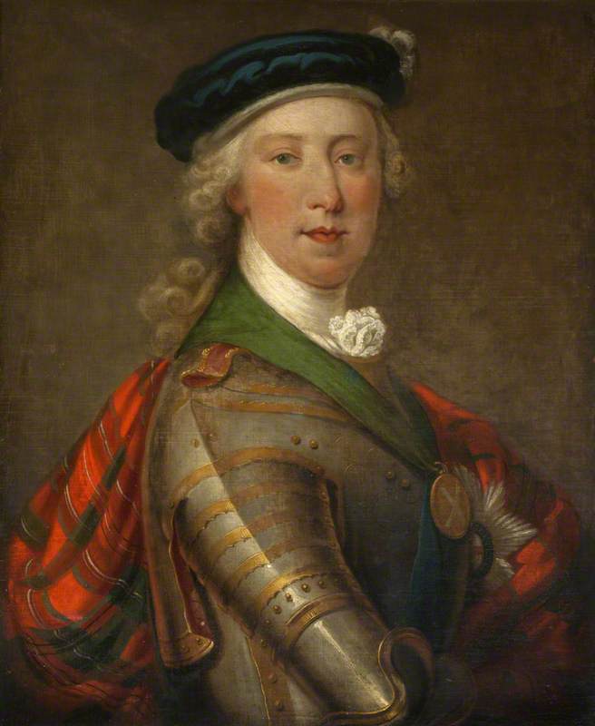
Prince Charles Edward Stuart
Charles Edward Louis John Sylvester Maria Casimir Stuart (31 December 1720 – 30 January 1788) was the elder son of James Francis Edward Stuart, making him the grandson of James VII and II, and the Stuart claimant to the thrones of England, Scotland, and Ireland from 1766 as Charles III. During his lifetime, he was also known as "the Young Pretender" and "the Young Chevalier"; in popular memory, he is known as Bonnie Prince Charlie. Born in Rome to the exiled Stuart court, he spent much of his early and later life in Italy. In 1744, he travelled to France to take part in a planned invasion to restore the Stuart monarchy under his father. When storms partly wrecked the French fleet, Charles resolved to proceed to Scotland following discussion with leading Jacobites. This resulted in Charles landing by ship on the west coast of Scotland, leading to the Jacobite rising of 1745. The Jacobite forces under Charles initially achieved several victories in the field, including the Ba ... [...More Info...] [...Related Items...] OR: [Wikipedia] [Google] [Baidu] |
Jacobite Rising Of 1745
The Jacobite rising of 1745 was an attempt by Charles Edward Stuart to regain the Monarchy of Great Britain, British throne for his father, James Francis Edward Stuart. It took place during the War of the Austrian Succession, when the bulk of the British Army was fighting in mainland Europe, and proved to be the last in Jacobite risings, a series of revolts that began in Jacobite rising of 1689, March 1689, with major outbreaks in Jacobite rising of 1715, 1715 and Jacobite rising of 1719, 1719. Charles launched the rebellion on 19 August 1745 at Glenfinnan in the Scottish Highlands, capturing Edinburgh and winning the Battle of Prestonpans in September. At a council in October, the Scots agreed to invade England after Charles assured them of substantial support from English Jacobitism, Jacobites and a simultaneous French landing in Southern England. On that basis, the Jacobite Army (1745), Jacobite army entered England in early November, but neither of these assurances proved ac ... [...More Info...] [...Related Items...] OR: [Wikipedia] [Google] [Baidu] |
Broadford, Skye
Broadford ( ), together with nearby Harrapool, is the second-largest settlement on the Isle of Skye, Scotland. Lying in the shadow of the Red Cuillin mountains, Broadford is within the parish of Strath. A long meandering village historically consisting of a few buildings on either side of the Broadford River, the many small townships around the wide sweep of the bay have grown together and Broadford now stretches for around the southern side of Broadford Bay. History Like many places in Skye, Broadford derives its name from Old Norse. To the Vikings, this was ''Breiðafjorðr'' – the wide bay. The Gaelic name is of modern derivation and assumes that the "ford" element meant a river crossing. West of Broadford in Glen Suardal, on the lower slopes of Beinn na Caillich, is Goir a' Bhlàir, 'the field of battle' ( ). The battle concerned was apparently a decisive action by the Gaelic Clan Mackinnon against the Norsemen. From the late 1700s Broadford was a cattle market. In ... [...More Info...] [...Related Items...] OR: [Wikipedia] [Google] [Baidu] |
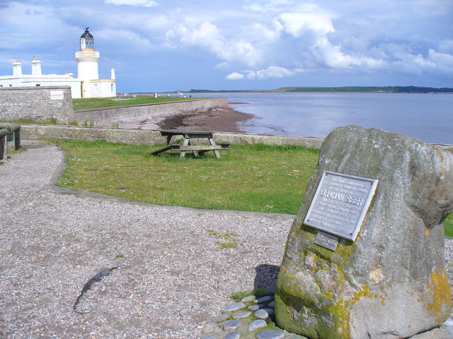
Brahan Seer
The Brahan Seer, known in his native Scottish Gaelic as Coinneach Odhar ("Dark Kenneth"), and Kenneth Mackenzie, was, according to legend, a predictor of the future who lived in the 17th century. The Brahan Seer is regarded by some to be the creation of the folklorist Alexander MacKenzie (1838–1898) whose accounts occur well after some of the events the Seer is claimed to have predicted. Others have also questioned whether the Seer existed at all. Early life Mackenzie is thought to have come from Uig (Lewis) on lands owned by the Seaforths, and to have been of the Clan Mackenzie, although both these details are in themselves questioned. He is better known, however, for his connections to Brahan Castle near Dingwall, and the Black Isle in Easter Ross. He is thought to have used an Adder stone, a stone with a hole in the middle, to see his visions. The Brahan Seer worked for Kenneth Mackenzie, 3rd Earl of Seaforth. As with Nostradamus, who wrote in Provençal, mo ... [...More Info...] [...Related Items...] OR: [Wikipedia] [Google] [Baidu] |
Roundhouse (dwelling)
A roundhouse is a type of house with a circular plan, usually with a conical roof. In the later part of the 20th century, modern designs of roundhouse eco-buildings were constructed with materials such as cob, cordwood or straw bale walls and reciprocal frame green roofs. Europe United Kingdom Roundhouses were the standard form of housing built in Britain and Ireland from the Bronze Age throughout the Iron Age, and in some areas well into the Sub Roman period. The people built walls made of either stone or of wooden posts joined by wattle-and-daub panels, and topped with a conical thatched roof. These ranged in size from less than 5m in diameter to over 15m. The Atlantic roundhouse, Broch, and Wheelhouse styles were used in Scotland. The remains of many Bronze Age roundhouses can still be found scattered across open heathland, such as Dartmoor, as stone ' hut circles'. Early archeologists determined what they believed were the characteristics of such structures by the l ... [...More Info...] [...Related Items...] OR: [Wikipedia] [Google] [Baidu] |
Iron Age
The Iron Age () is the final epoch of the three historical Metal Ages, after the Chalcolithic and Bronze Age. It has also been considered as the final age of the three-age division starting with prehistory (before recorded history) and progressing to protohistory (before written history). In this usage, it is preceded by the Stone Age (subdivided into the Paleolithic, Mesolithic and Neolithic) and Bronze Age. These concepts originated for describing Iron Age Europe and the ancient Near East. In the archaeology of the Americas, a five-period system is conventionally used instead; indigenous cultures there did not develop an iron economy in the pre-Columbian era, though some did work copper and bronze. Indigenous metalworking arrived in Australia with European contact. Although meteoric iron has been used for millennia in many regions, the beginning of the Iron Age is defined locally around the world by archaeological convention when the production of Smelting, smelted iron (espe ... [...More Info...] [...Related Items...] OR: [Wikipedia] [Google] [Baidu] |
Lyre
The lyre () (from Greek λύρα and Latin ''lyra)'' is a string instrument, stringed musical instrument that is classified by Hornbostel–Sachs as a member of the History of lute-family instruments, lute family of instruments. In organology, a lyre is considered a yoke lute, since it is a lute in which the strings are attached to a yoke that lies in the same plane as the sound table, and consists of two arms and a crossbar. The lyre has its origins in ancient history. Lyres were used in several ancient cultures surrounding the Mediterranean Sea. The earliest known examples of the lyre have been recovered at archeological sites that date to c. 2700 BCE in Mesopotamia. The oldest lyres from the Fertile Crescent are known as the eastern lyres and are distinguished from other ancient lyres by their flat base. They have been found at archaeological sites in Egypt, Syria, Anatolia, and the Levant. In a discussion of the Nubian lyre, Carl Engel notes that modern Egyptians call it ... [...More Info...] [...Related Items...] OR: [Wikipedia] [Google] [Baidu] |
Roman Empire
The Roman Empire ruled the Mediterranean and much of Europe, Western Asia and North Africa. The Roman people, Romans conquered most of this during the Roman Republic, Republic, and it was ruled by emperors following Octavian's assumption of effective sole rule in 27 BC. The Western Roman Empire, western empire collapsed in 476 AD, but the Byzantine Empire, eastern empire lasted until the fall of Constantinople in 1453. By 100 BC, the city of Rome had expanded its rule from the Italian peninsula to most of the Mediterranean Sea, Mediterranean and beyond. However, it was severely destabilised by List of Roman civil wars and revolts, civil wars and political conflicts, which culminated in the Wars of Augustus, victory of Octavian over Mark Antony and Cleopatra at the Battle of Actium in 31 BC, and the subsequent conquest of the Ptolemaic Kingdom in Egypt. In 27 BC, the Roman Senate granted Octavian overarching military power () and the new title of ''Augustus (title), Augustus'' ... [...More Info...] [...Related Items...] OR: [Wikipedia] [Google] [Baidu] |
High Pasture Cave
High Pasture Cave (Gaelic: ''Uamh An Ard-Achaidh'') is an archaeological site on the island of Skye, Scotland. Human presence is documented since the Mesolithic, and remains, including Iron Age structures, point to ritual veneration of either the landscape or deities associated with the place. The cave system extends to about of accessible passages Site The cave is about southeast of the village of Torrin, near Kilbride. The entrance of the cave lies in a narrow valley on the northern slopes of the mountain of Beinn Dùbhaich, east of the Red Cuillin hills, and is formed by erosion of ''Durness'' limestone. The interior is accessed via a natural shaft about deep that leads into the main cave, which appears to have been in use between 1,200 BC and 200 BC (mid-Bronze Age to late Iron Age). After about there is a fork, with a rocky, dry passage on the right. In 2002 the cave explorer Steven Birch discovered broken crockery and bones. Previous visitors to the cave had thrown ... [...More Info...] [...Related Items...] OR: [Wikipedia] [Google] [Baidu] |
Ross And Cromarty
Ross and Cromarty (), is an area in the Highlands and Islands of Scotland. In modern usage, it is a registration county and a Lieutenancy areas of Scotland, lieutenancy area. Between 1889 and 1975 it was a Shires of Scotland, county. Historically, Ross-shire and Cromartyshire were separate counties, with Cromartyshire comprising a number of disconnected tracts of land scattered across Ross-shire. The two counties shared a Sheriff of Ross and Cromarty, sheriff from 1748, and were both included in the Ross and Cromarty (UK Parliament constituency), Ross and Cromarty constituency from 1832. They were formally united into a single county called Ross and Cromarty in 1889. The mainland part of the county had a coast to the east onto the Moray Firth, and a coast to the west onto the Minch. Much of the mainland is sparsely populated, including parts of the Northwest Highlands mountains. The mainland's principal towns are all on the east coast, including Dingwall (the county town), Alnes ... [...More Info...] [...Related Items...] OR: [Wikipedia] [Google] [Baidu] |


