|
Khatoli
Khatoli is a panchayat village2011 Village Panchayat Code = 16828, in Sult Tehsil, Almora District Almora is a district in the Kumaon Division of Uttarakhand state, India. The headquarters is at Almora. It is 1,638 meters above sea level. The neighbouring regions are Pithoragarh district to the east, Chamoli district to the west, Bageshwar d ..., Uttarakhand State, India.2001 Census Village code = 1199100, Before Sult Tehsil was created as a result of the 2001 census, Khatoli was in Bhikiya Sain Tehsil. Khatoli is the only village in the Khatoli Gram Panchyat.2011 Census Village code = 052245, Notes {{coord missing, Uttarakhand Villages in Almora district ... [...More Info...] [...Related Items...] OR: [Wikipedia] [Google] [Baidu] |
Sult, Uttarakhand
Salt or Sult ( hi, सल्ट) is a block in Almora district, Uttarakhand, India. It is also known as Kumaun Ki Bardoli, a name given to it by Mahatma Gandhi Mohandas Karamchand Gandhi (; ; 2 October 1869 – 30 January 1948), popularly known as Mahatma Gandhi, was an Indian lawyer, anti-colonial nationalist Quote: "... marks Gandhi as a hybrid cosmopolitan figure who transformed ... anti- ... when he visited Almora in 1929. Khumar is a village located in Salt which has a Martyr Monument. Villages Villages in the Sult subdistrict: References {{Coord, 29.66, 79.16, display=title Almora district Tehsils of India ... [...More Info...] [...Related Items...] OR: [Wikipedia] [Google] [Baidu] |
Panchayat Village
Gram Panchayat () is a basic village-governing institute in Indian villages. It is a democratic structure at the grass-roots level in India. It is a political institute, acting as cabinet of the village. The Gram Sabha work as the general body of the Gram Panchayat. The members of the Gram Panchayat are elected by the Gram Sabha. There are about 250,000+ Gram Panchayats in India. History Established in various states of India, the Panchayat Raj system has three tiers: Zila Parishad, at the district level; Panchayat Samiti, at the block level; and Gram Panchayat, at the village level. Rajasthan was the first state to establish Gram Panchayat, Bagdari Village (Nagaur District) being the first village where Gram Panchayat was established, on 2 October 1959. The failed attempts to deal with local matters at the national level caused, in 1992, the reintroduction of Panchayats for their previously used purpose as an organisation for local self-governance. Structure Gram P ... [...More Info...] [...Related Items...] OR: [Wikipedia] [Google] [Baidu] |
Almora District
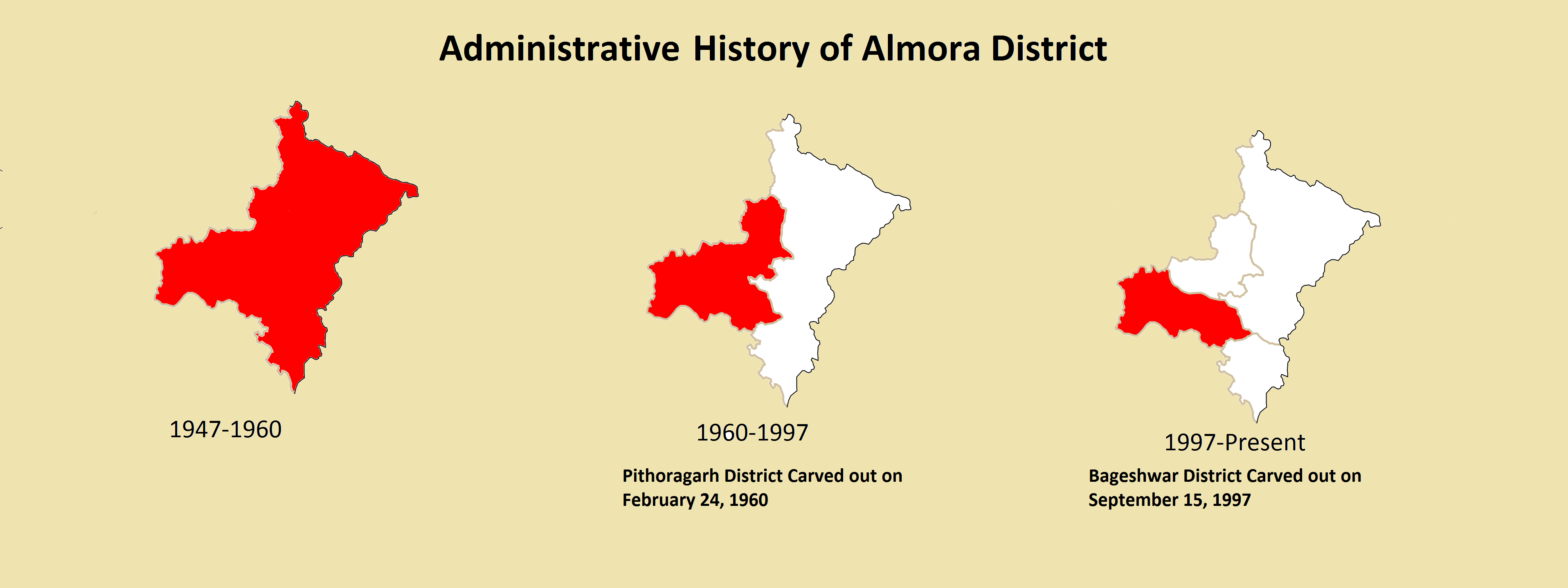
Almora is a District (India), district in the Kumaon Division of Uttarakhand state, India. The headquarters is at Almora. It is 1,638 meters above sea level. The neighbouring regions are Pithoragarh district to the east, Chamoli district to the west, Bageshwar district to the north and Nainital district to the south. History The ancient town of Almora was capital of the Kumaon Kingdom, before its establishment, it was under the possession of Katyuri Kings, Katyuri king Baichaldeo. Later on when the Chand dynasty was founded in Champawat, the town of Almora was founded at this centrally located place in 1568 by Kalyan Chand. Later Chand kings shifted the capital of the Kumaon Kingdom from Champawat to Almora. Almora town was the administrative headquarter of the Kumaun district; that was formed in 1815 following the defeat of Gorkha army in the Anglo-Gorkha war and the 1816 Treaty of Sugauli. The Kumaun district then consisted of the complete Kumaon Division excluding the Udham ... [...More Info...] [...Related Items...] OR: [Wikipedia] [Google] [Baidu] |
Uttarakhand
Uttarakhand ( , or ; , ), also known as Uttaranchal ( ; the official name until 2007), is a state in the northern part of India. It is often referred to as the "Devbhumi" (literally 'Land of the Gods') due to its religious significance and numerous Hindu temples and pilgrimage centres found throughout the state. Uttarakhand is known for the natural environment of the Himalayas, the Bhabar and the Terai regions. It borders the Tibet Autonomous Region of China to the north; the Sudurpashchim Province of Nepal to the east; the Indian states of Uttar Pradesh to the south and Himachal Pradesh to the west and north-west. The state is divided into two divisions, Garhwal and Kumaon, with a total of 13 districts. The winter capital of Uttarakhand is Dehradun, the largest city of the state, which is a rail head. Bhararisain, a town in Chamoli district, is the summer capital of Uttarakhand. The High Court of the state is located in Nainital. Archaeological evidence supports the e ... [...More Info...] [...Related Items...] OR: [Wikipedia] [Google] [Baidu] |

