|
Kenyan Rift
The Great Rift Valley is part of an intra-continental ridge system that runs through Kenya from north to south. It is part of the Gregory Rift, the eastern branch of the East African Rift, which starts in Tanzania to the south and continues northward into Ethiopia. It was formed on the "Kenyan Dome" a geographical upwelling created by the interactions of three major tectonics: the Arabian, Nubian, and Somalian plates. In the past, it was seen as part of a "Great Rift Valley" that ran from Madagascar to Syria. Most of the valley falls within the former Rift Valley Province. The valley contains the Cherangani Hills and a chain of volcanoes, some of which are still active. The climate is mild, with temperatures usually below . Most rain falls during the March–June and October–November periods. The Tugen Hills to the west of Lake Baringo contain fossils preserved in lava flows from the period 14 to 4 million years ago. The relics of many hominids, ancestors of humans, have be ... [...More Info...] [...Related Items...] OR: [Wikipedia] [Google] [Baidu] |
Lake Turkana
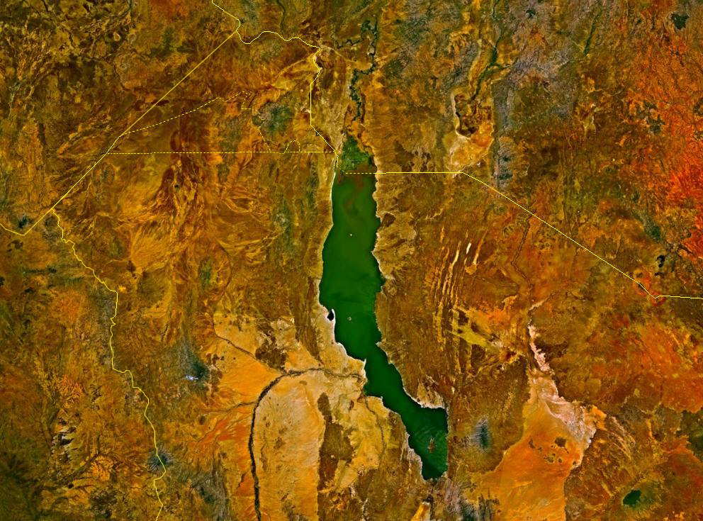
Lake Turkana (), formerly known as Lake Rudolf, is a lake in the Kenyan Rift Valley, in northern Kenya, with its far northern end crossing into Ethiopia. It is the world's largest permanent desert lake and the world's largest alkaline lake. By volume it is the world's fourth-largest salt lake after the Caspian Sea, Issyk-Kul, and Lake Van (passing the shrinking South Aral Sea), and among all lakes it ranks 24th. Lake Turkana is now threatened by the construction of Gilgel Gibe III Dam in Ethiopia due to the damming of the Omo river which supplies most of the lake's water. Although the lake commonly has been —and to some degree still is— used for drinking water, its salinity (slightly brackish) and very high levels of fluoride (much higher than in fluoridated water) generally make it unsuitable, and it has also been a source of diseases spread by contaminated water. Increasingly, communities on the lake's shores rely on underground springs for drinking water. The same c ... [...More Info...] [...Related Items...] OR: [Wikipedia] [Google] [Baidu] |
Hell's Gate National Park
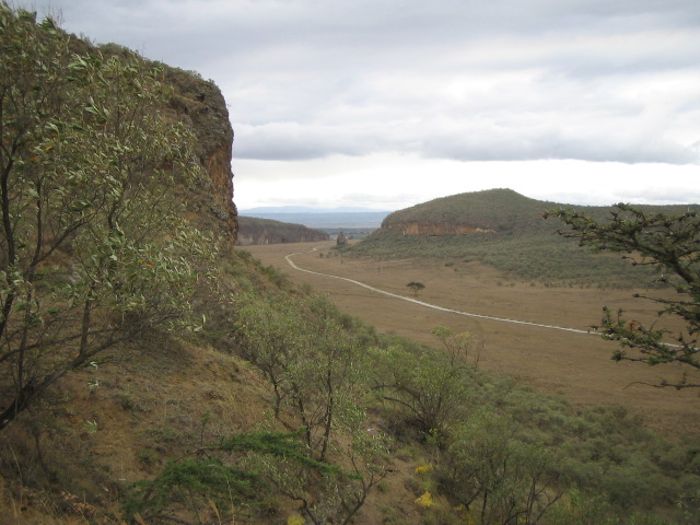
Hell's Gate National Park lies south of Lake Naivasha in Kenya, north west of Nairobi. Hell's Gate National Park is named after a narrow break in the cliffs, once a tributary of a prehistoric lake that fed early humans in the Rift Valley. It was established in 1984. A small national park, it is known for its wide variety of wildlife and for its scenery. This includes the Fischer's Tower and Central Tower columns and Hell's Gate Gorge. The national park is also home to five geothermal power stations at Olkaria. The park is equipped with three basic campsites and includes a Maasai Cultural Center, providing education about the Maasai tribe's culture and traditions. History Hell's Gate National Park is named after a narrow break in the cliffs, once a tributary of a prehistoric lake that fed early humans in the Rift Valley. It received the name "Hell's Gate" by explorers Fisher and Thomson in 1883. In the early 1900s, Mount Longonot erupted, and ash can still be felt around Hel ... [...More Info...] [...Related Items...] OR: [Wikipedia] [Google] [Baidu] |
Lake Naivasha
Lake Naivasha is a freshwater lake in Kenya, outside the town of Naivasha in Nakuru County, which lies north west of Nairobi. It is part of the Great Rift Valley. The name derives from the local Maasai name ''Nai'posha'', meaning "rough water" because of the sudden storms which can arise. Location Lake Naivasha is at the highest elevation of the Kenyan Rift valley at in a complex geological combination of volcanic rocks and sedimentary deposits from a larger Pleistocene Era lake. Apart from transient streams, the lake is fed by the perennial Malewa and Gilgil rivers. There is no visible outlet, but since the lake water is relatively fresh it is assumed to have an underground outflow. The lake had a normal surface area of "THE OUTFLOW OF LAKE NAIVASHA BASED ON THE STABLE ISOTOPE COMPOSITION" (characteristics), M.K. Arusei, J. K Sanga, M.P Tole, Department of Chemistry, School of Environmental Studies, Moi University, P.O Box 3900 Eldoret, Kenya, webpagUNEP-Moi-Arusei-PD ... [...More Info...] [...Related Items...] OR: [Wikipedia] [Google] [Baidu] |
Mount Kipipiri
Mount Kipipiri is an isolated volcano in the Wanjohi Valley, on the Kinangop Plateau near to the Aberdare Range. It is about northeast of Lake Naivasha, which is visible from the summit. Wildlife includes Colobus and Sykes monkeys, elephants and buffalo and abundant birdlife. The name of the mountain means "butterfly" in the Gikuyu language, a reference to its profile from a distance. The Mount Kipipiri Forest Reserve is part of the Aberdare National Park. In 2005 it was estimated that the forest reserve was home to about 13 elephants. In June 2009 lengthy negotiations were concluded over the alignment of a wildlife corridor A wildlife corridor, habitat corridor, or green corridor is an area of habitat connecting wildlife populations separated by human activities or structures (such as roads, development, or logging). This allows an exchange of individuals between ... between Kipipiri and the main Aberdare park, with plans to fence the corridor. Grids of rolling bars with ... [...More Info...] [...Related Items...] OR: [Wikipedia] [Google] [Baidu] |
Lake Elementaita
Lake Elmenteita is a soda lake, in the Great Rift Valley, about 120 km northwest of Nairobi, Kenya. Geography Elmenteita is derived from the Maasai word , meaning "dust place", a reference to the dryness and dustiness of the area, especially between January and March. The town of Gilgil is near the lake. In the south-to-north sequence of Rift Valley lakes, Elmenteita is between Lake Naivasha and Lake Nakuru. The major Nairobi-Nakuru highway (A104 Road) runs along the nearby escarpment affording motorists a spectacular vista towards the lake. Today the lake is a protected area due to its bird life, and has been named as an UNESCO heritage site together with Lake Nakuru and Lake Bogoria. At the southern end of the lake are the "Kekopey" hot springs, in which an introduced fish, the Lake Magadi tilapia, breed. The reed beds nearby are fishing grounds for night herons and pelicans. History The Lake Elmenteita area saw its first white settlement when Lord Delamere ... [...More Info...] [...Related Items...] OR: [Wikipedia] [Google] [Baidu] |
Lake Nakuru
Lake Nakuru is one of the Rift Valley lakes at an elevation of above sea level. It lies to the south of Nakuru, in the rift valley of Kenya and is protected by Lake Nakuru National Park. The lake's abundance of algae used to attract a vast quantity of flamingos that famously lined the shore. Other birds also flourish in the area, as do warthogs, baboons and other large mammals. Eastern black rhinos and southern white rhinos have also been introduced. The lake's level dropped dramatically in the early 1990s but has since largely recovered. In 2013, the lake received an alarming increase in the water levels that led to the migration of flamingos to Lake Bogoria in search for food supply. Between 2010-2020 Lake Nakuru increased in surface area from 40 to 68 square kilometres. 677 households, parts of Nakuru town and National Park areas had been flooded. Nakuru means "Dust or Dusty Place" in the Maasai language. Lake Nakuru National Park, close to Nakuru town, was established in ... [...More Info...] [...Related Items...] OR: [Wikipedia] [Google] [Baidu] |
Menengai
Menengai Crater is a massive shield volcano with one of the biggest calderas in the world, in the Great Rift Valley, Kenya. It is the largest volcano caldera in Kenya and the second largest volcano caldera in Africa. Volcanic formed rich loam soils enrich the adjacent farmland arounds its flanks. The crater is on the floor of the Rift Valley. The volcano formed about 200,000 years ago and the prominent 12 x 8 km caldera formed about 8000 years ago. The caldera floor is covered with numerous post caldera lava flows. The Menengai volcano is considered one of the best-preserved Krakatau-style calderas in the world. Menengai has very little sediment in the caldera which is a thick mass of lava boulders and inaccessible ridges. Volcanic activity continues and a current project under thGDCis at an advanced stage towards geothermal power generation. Menengai is north of Nakuru, the fourth-biggest city in Kenya. See also * List of volcanoes in Kenya * Menengai Forest Menen ... [...More Info...] [...Related Items...] OR: [Wikipedia] [Google] [Baidu] |
Lake Bogoria
Lake Bogoria (formerly Lake Hannington) is a saline, alkaline lake that lies in a volcanic region in a half-graben basin south of Lake Baringo, Kenya, a little north of the equator. Lake Bogoria, like Lake Nakuru, Lake Elementeita, and Lake Magadi further south in the Rift Valley, and Lake Logipi to the north, is home at times to one of the world's largest populations of lesser flamingos. The lake is a Ramsar site and Lake Bogoria National Reserve has been a protected National Reserve since November 29, 1973. Lake Bogoria is shallow (about 10 m depth), and is about 34 km long by 3.5 km wide, with a drainage basin of 700 km2. It is Located in Baringo County. Local features include the Kesubo Swamp to the north and the Siracho Escarpment to the east, both within the National Reserve. The lake is also famous for geysers and hot springs along the bank of the lake and in the lake. In four locations around the lake can be observed at least 10 geysers, which erupt up to ... [...More Info...] [...Related Items...] OR: [Wikipedia] [Google] [Baidu] |
Lake Baringo
Lake Baringo is, after Lake Turkana, the most northern of the Kenyan Rift Valley lakes, with a surface area of and an elevation of . The lake is fed by several rivers: the Molo, Perkerra and Ol Arabel. It has no obvious outlet; the waters are assumed to seep through lake sediments into the faulted volcanic bedrock. It is one of the two freshwater lakes in the Rift Valley in Kenya, the other being Lake Naivasha. See "Kenya designates freshwater lake in Great Rift Valley," aRamsar 2009 - 2002 The lake is in a remote hot and dusty area with over 470 species of birds, occasionally including migrating flamingos. A Goliath heronry is located on a rocky islet in the lake known as Gibraltar. Description The lake is part of the East African Rift system. The Tugen Hills, an uplifted fault block of volcanic and metamorphic rocks, lies west of the lake. The Laikipia Escarpment lies to the east. Water flows into the lake from the Mau Hills and Tugen Hills. It is a critical habitat a ... [...More Info...] [...Related Items...] OR: [Wikipedia] [Google] [Baidu] |
Mount Korosi
Korosi is a shield volcano located in the Gregory Rift at the northern end of Lake Baringo, Kenya. See also * List of volcanoes in Kenya References * Korosi Korosi Korosi is a shield volcano located in the Gregory Rift at the northern end of Lake Baringo, Kenya. See also * List of volcanoes in Kenya This is a short list of active and extinct volcanoes in Kenya.For a more comprehensive list of volcanoe ... Korosiol {{Kenya-geo-stub ... [...More Info...] [...Related Items...] OR: [Wikipedia] [Google] [Baidu] |
Paka (volcano)
Paka is a shield volcano located in the Great Rift Valley, Kenya. Geothermal activity is widespread at Paka. Paka means "ochre" in Pokot. See also * List of volcanoes in Kenya This is a short list of active and extinct volcanoes in Kenya.For a more comprehensive list of volcanoes and craters in Kenya, see :sw:Orodha ya volkeno nchini Kenya List of volcanoes in Kenya (non-exhaustive) References * Volcanoes of ... References * Mountains of Kenya Volcanoes of Kenya Polygenetic shield volcanoes Active volcanoes {{Kenya-geo-stub ... [...More Info...] [...Related Items...] OR: [Wikipedia] [Google] [Baidu] |


