|
Kedayan River
Kedayan River () is a tributary of the Brunei River which flows through the capital of Brunei, Bandar Seri Begawan. History On 22 October 2017, the Taman Mahkota Jubli Emas public park was officially opened. It was part of the Sungai Kedayan Eco-Corridor Project which aims to redevelop the area. The consequence of this project caused Kampong Sungai Kedayan, one of the oldest village in the area, to be demolished. See also * List of rivers of Brunei This is a list of rivers in Brunei. Longest river by district Rivers by district Belait * ''Belait River, Belait'' *''Geriting River, Geriting'' *''Gana River, Gana'' *''Lumut River, Lumut'' *''Kang River, Kang'' *''Liang Kecil River, L ... Rivers of Brunei References [...More Info...] [...Related Items...] OR: [Wikipedia] [Google] [Baidu] |
Brunei
Brunei ( , ), formally Brunei Darussalam ( ms, Negara Brunei Darussalam, Jawi alphabet, Jawi: , ), is a country located on the north coast of the island of Borneo in Southeast Asia. Apart from its South China Sea coast, it is completely surrounded by the Malaysian state of Sarawak. It is separated into two parts by the Sarawak district of Limbang District, Limbang. Brunei is the only sovereign state entirely on Borneo; the remainder of the island is divided between Malaysia and Indonesia. , its population was 460,345, of whom about 100,000 live in the Capital city, capital and largest city, Bandar Seri Begawan. The government of Brunei, government is an absolute monarchy ruled by its Sultan of Brunei, Sultan, entitled the Yang di-Pertuan Negara, Yang di-Pertuan, and implements a combination of English common law and sharia law, as well as general Islamic practices. At the peak of the Bruneian Empire, Bolkiah, Sultan Bolkiah (reigned 1485–1528) is claimed to have had contro ... [...More Info...] [...Related Items...] OR: [Wikipedia] [Google] [Baidu] |
Districts Of Brunei
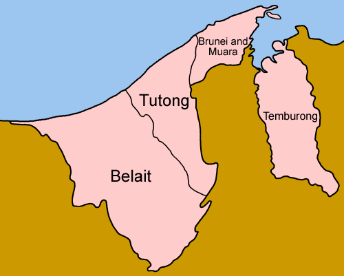
Districts () are the principal administrative divisions of Brunei. The country is divided into four districts, namely Brunei-Muara, Belait, Tutong and Temburong. Temburong is an exclave; it is physically separated from the three other districts by the Brunei Bay and Malaysian state of Sarawak. Each district has a town as its administrative and main economic centre, with the exception of Brunei-Muara, where the principal centre is Bandar Seri Begawan, a city and the country's capital. History The country previously had six districts, namely Brunei, Muara, Limau Manis (also known as Ulu Brunei), Tutong, Belait and Temburong. In 1908 Brunei and Limau Manis were merged, and in 1938 the districts were restructured to form the present-day four districts. Administration Each district is administered by a District Office (), where District Offices are government departments under the Ministry of Home Affairs. The head of each department is a District Officer () and appointed ... [...More Info...] [...Related Items...] OR: [Wikipedia] [Google] [Baidu] |
Brunei-Muara District
Brunei-Muara District ( ms, Daerah Brunei dan Muara; Jawi: برونائی-موارا ضلع) or simply Brunei-Muara is one of the four districts of Brunei. It has the smallest area among the four districts, with , yet is the most populous, with 289,630 people as of 2016. Bandar Seri Begawan, the country's capital, is located in this district, which is also de facto the district's capital. It is also home to Brunei International Airport, the country's only international airport, as well as Muara Port, the main and only deep-water port in the country. The Brunei River flows within this district and is home to Kampong Ayer, the traditional historic settlement on stilts above the river. Geography The district borders the South China Sea to the north, Brunei Bay to the east, Limbang District in the Malaysian state of Sarawak to the south, and Tutong District to the west. The Brunei River is the sole primary river and only flows in the district. It begins in the south-western pa ... [...More Info...] [...Related Items...] OR: [Wikipedia] [Google] [Baidu] |
Mukims Of Brunei
A mukim is the second-level administrative division of Brunei, and the primary subdivision of a district. There are 39 mukims in the country. A mukim is led by a . A mukim encompasses a number of villages A village is a clustered human settlement or community, larger than a hamlet but smaller than a town (although the word is often used to describe both hamlets and smaller towns), with a population typically ranging from a few hundred to ... ( or ). Mukims are administered by the district office of the district where they are located. List of mukims References Subdivisions of Brunei Brunei, Mukims Brunei 2 Mukims, Brunei Brunei geography-related lists {{Brunei-geo-stub ... [...More Info...] [...Related Items...] OR: [Wikipedia] [Google] [Baidu] |
Mukim Sungai Kedayan
Mukim Sungai Kedayan was a mukim in Brunei-Muara District, Brunei. It was located within Kampong Ayer, the historical stilt settlements on the Brunei River in the capital Bandar Seri Begawan. The population was 230 in 2016. Name The name of the mukim could be named after the village it encompasses, Kampong Sungai Kedayan. The wealthy traders used to reside in Kampong Sungai Kedayan, and the majority of senior government officials came from there. Villages Majority of the villages in the mukim no longer exists; as of 2016, the only populated village is Kampong Sumbiling Lama. This is due to an urban regeneration project undertaken by the government in mid-2010s which involved redeveloping parts of the river banks of Sungai Kedayan adjacent to the city centre into an urban park (now known as Taman Mahkota Jubli Emas). The area had been occupied by the aforementioned villages, hence to make way for the project the residents had been relocated, mainly to the available public ho ... [...More Info...] [...Related Items...] OR: [Wikipedia] [Google] [Baidu] |
Brunei River
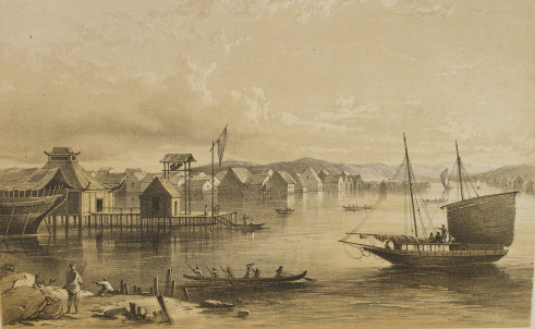
The Brunei River ( ms, Sungai Brunei) is a river which flows through Brunei and empties into the Brunei Bay towards the north-east direction. The Istana Nurul Iman, the official residence of the Sultan of Brunei, stands on its banks. The Brunei River is the shortest major river in Brunei. It is the major river basin within the Brunei-Muara District, the smallest but most populous district. It flows through the country's capital Bandar Seri Begawan. It is home to Kampong Ayer, the Brunei's traditional village on stilts above the river water. History The Sultanate of Brunei once controlled all Borneo, including parts of the Philippines and Indonesia. The region's thick jungle means the method of transport and communication was always via boats. This led to traditional settlements being established beside rivers and waterways. These waterways provided convenient transport through a jungle environment, and a supply of food. In 2006 the Brunei government through the Ministry o ... [...More Info...] [...Related Items...] OR: [Wikipedia] [Google] [Baidu] |
Bandar Seri Begawan
Bandar Seri Begawan (BSB; Jawi: بندر سري بڬاوان; ) is the capital city of Brunei. It is officially a municipal area () with an area of and an estimated population of 100,700 as of 2007. It is part of Brunei-Muara District, the smallest yet most populous district which is home to over 70 per cent of the country's population. It is the country's largest urban centre and nominally the country's only city. The capital is home to Brunei's seat of government, as well as a commercial and cultural centre. It was formerly known as Brunei Town until it was renamed in 1970 in honour of Sultan Omar Ali Saifuddien III, the 28th Sultan of Brunei and the father of the current Sultan Hassanal Bolkiah. The history of Bandar Seri Begawan can be traced back to the establishment of a Malay stilt settlement on the waters of the Brunei River which became the predecessor of Kampong Ayer today. It became the capital of the Bruneian Sultanate from the 16th century onwards, as well as i ... [...More Info...] [...Related Items...] OR: [Wikipedia] [Google] [Baidu] |
Taman Mahkota Jubli Emas
Taman Mahkota Jubli Emas (from the Malay name, literally 'Golden Jubilee Crown Park'), initially known as Eco-Corridor Park (), is a riverfront public park in Bandar Seri Begawan, Brunei. The park was inaugurated on 22 October 2017 in conjunction with the Golden Jubilee of Sultan Hassanal Bolkiah's accession to the throne as the 29th and current Sultan of Brunei. Background The park was the primary outcome of the Sungai Kedayan Eco-Corridor project (hence the name Eco-Corridor Park), a project to revitalise the Kedayan River through flood mitigation, environmental rehabilitation and development of public spaces. The project is also part of the broader Bandar Seri Begawan Development Master Plan which aims to revitalise the capital, particularly in the city centre, with further developments of commercial, residential, social and utility infrastructures. History The construction on the park began in January 2016 as part of the 10th National Development Plan ( or ''RKN10'' ... [...More Info...] [...Related Items...] OR: [Wikipedia] [Google] [Baidu] |
Tributary
A tributary, or affluent, is a stream or river that flows into a larger stream or main stem (or parent) river or a lake. A tributary does not flow directly into a sea or ocean. Tributaries and the main stem river drain the surrounding drainage basin of its surface water and groundwater, leading the water out into an ocean. The Irtysh is a chief tributary of the Ob river and is also the longest tributary river in the world with a length of . The Madeira River is the largest tributary river by volume in the world with an average discharge of . A confluence, where two or more bodies of water meet, usually refers to the joining of tributaries. The opposite to a tributary is a distributary, a river or stream that branches off from and flows away from the main stream. PhysicalGeography.net, Michael Pidwirny & S ... [...More Info...] [...Related Items...] OR: [Wikipedia] [Google] [Baidu] |
Public Park
An urban park or metropolitan park, also known as a municipal park (North America) or a public park, public open space, or municipal gardens ( UK), is a park in cities and other incorporated places that offer recreation and green space to residents of, and visitors to, the municipality. The design, operation, and maintenance is usually done by government agencies, typically on the local level, but may occasionally be contracted out to a park conservancy, "friends of" group, or private sector company. Common features of municipal parks include playgrounds, gardens, hiking, running and fitness trails or paths, bridle paths, sports fields and courts, public restrooms, boat ramps, and/or picnic facilities, depending on the budget and natural features available. Park advocates claim that having parks near urban residents, including within a 10-minute walk, provide multiple benefits. History A park is an area of open space provided for recreational use, usually owned and mainta ... [...More Info...] [...Related Items...] OR: [Wikipedia] [Google] [Baidu] |
List Of Rivers Of Brunei
This is a list of rivers in Brunei. Longest river by district Rivers by district Belait * '' Belait'' *'' Geriting'' *'' Gana'' *'' Lumut'' *''Kang'' *'' Liang Kecil'' *'' Kayu Ara'' *'' Anduki'' *'' Bera'' *''Seria'' *'' Mendaram'' *'' Damit'' *'' Bedas'' *'' Premat'' *'' Baran'' Tutong *'' Tutong'' *'' Kelakas'' *'' Danau'' *'' Birau'' *'' Sembatang'' *'' Kalamang'' *'' Kelugus'' *'' Pentyatang'' *'' Pepakan'' *'' Tempikku'' *'' Telamba'' Temburong *'' Pandaruan'' *''Temburong'' *'' Belayang'' *''Kibi'' *'' Labu'' *'' Luagan'' *'' Lamaling Besar'' *'' Lakiun'' *'' Kutop'' Brunei-Muara *''Brunei'' *''Berakas'' *'' Limbang'' *'' Butir'' *'' Menunggul'' *'' Kedayan'' *'' Damuan'' *'' Teritip'' *'' Mentiri'' *'' Salar'' *'' Pagalayan'' *'' Mangsalut'' *''Kianggeh'' References External links * * - Topographic US Army map of Western Brunei. * - Topographic US Army map of Eastern Brunei. {{Asia topic, List of rivers of * Brunei Rivers A river is ... [...More Info...] [...Related Items...] OR: [Wikipedia] [Google] [Baidu] |


.jpg)