|
Katima Mulilo
Katima Mulilo or simply Katima is the capital of the Zambezi Region in Namibia. It is located in the Caprivi Strip. It had 28,362 inhabitants in 2010, and comprises two electoral constituencies, Katima Mulilo Rural and Katima Mulilo Urban. It is located on the national road B8 on the banks of the Zambezi River in lush riverine vegetation with tropical birds and monkeys. The town receives an annual average rainfall of . The nearest Namibian town to Katima Mulilo is Rundu, about 500 km away. About 40 km east of Katima Mulilo lies the village of Bukalo, where the road to Ngoma branches off that joins Namibia to Botswana. Economy and infrastructure Established and run as a garrison for a long time, Katima Mulilo still shows signs of its military role today. In the city centre was the South African Defence Force military base, almost every house had a bomb shelter. The town benefited from the military presence in terms of infrastructure and employment, and there are ... [...More Info...] [...Related Items...] OR: [Wikipedia] [Google] [Baidu] |
Zambezi River
The Zambezi River (also spelled Zambeze and Zambesi) is the fourth-longest river in Africa, the longest east-flowing river in Africa and the largest flowing into the Indian Ocean from Africa. Its drainage basin covers , slightly less than half of the Nile's. The river rises in Zambia and flows through eastern Angola, along the north-eastern border of Namibia and the northern border of Botswana, then along the border between Zambia and Zimbabwe to Mozambique, where it crosses the country to empty into the Indian Ocean. The Zambezi's most noted feature is Victoria Falls. Its other falls include the Chavuma Falls at the border between Zambia and Angola, and Ngonye Falls near Sioma in western Zambia. The two main sources of hydroelectric power on the river are the Kariba Dam, which provides power to Zambia and Zimbabwe, and the Cahora Bassa Dam in Mozambique, which provides power to Mozambique and South Africa. Additionally, two smaller power stations are along the Zambezi ... [...More Info...] [...Related Items...] OR: [Wikipedia] [Google] [Baidu] |
Bukalo
Bukalo is a village in Namibia. It is situated in the Zambezi Region 43 kilometres away from the region’s capital, Katima Mulilo. It is also the Royal Headquarters of the Subia people. In 2013, it was upgraded from a settlement to a village with its own village council by the former President of Namibia, Hifikepunye Pohamba. Name The name Bukalo is from the word Buikalo which simply means ‘Settlement’ in the Ikuhane language ( Chikuhane). History The Subia are a Bantu speaking ethnic group that migrated southward of Africa. One group went to Zambia and another to Botswana. King Mutwa Liswani II (1965 – 1996) set his palace up in present day Bukalo and established the Subia Royal Headquarters there. Politics In 2013 it was proclaimed village by the former President of Namibia, Hifikepunye Pohamba. Bukalo is governed by the Bukalo Village Council which is the local authority responsible for its administration. It has five seats, headed by a chief executive officer, a cha ... [...More Info...] [...Related Items...] OR: [Wikipedia] [Google] [Baidu] |
Caprivi Highway Near Katima Aerial , German Chancellor 1890–1894
{{Disambig, geo, surname ...
Caprivi may refer to: Places * Caprivi Region, a former name of Zambezi Region, an administrative region of Namibia * Caprivi Strip, a part of Namibia * Caprivi conflict, a secession attempt by the Caprivi Liberation Army and the Namibian government * East Caprivi, a former Lozi bantustan in South West Africa * Caprivi, Pennsylvania, an unincorporated community in Cumberland County, Pennsylvania, USA People * Leo von Caprivi Georg Leo Graf von Caprivi de Caprara de Montecuccoli ( English: ''Count George Leo of Caprivi, Caprara, and Montecuccoli''; born Georg Leo von Caprivi; 24 February 1831 – 6 February 1899) was a German general and statesman who served as the c ... [...More Info...] [...Related Items...] OR: [Wikipedia] [Google] [Baidu] |
Diarrhea
Diarrhea, also spelled diarrhoea, is the condition of having at least three loose, liquid, or watery bowel movements each day. It often lasts for a few days and can result in dehydration due to fluid loss. Signs of dehydration often begin with loss of the normal stretchiness of the skin and irritable behaviour. This can progress to decreased urination, loss of skin color, a fast heart rate, and a decrease in responsiveness as it becomes more severe. Loose but non-watery stools in babies who are exclusively breastfed, however, are normal. The most common cause is an infection of the intestines due to either a virus, bacterium, or parasite—a condition also known as gastroenteritis. These infections are often acquired from food or water that has been contaminated by feces, or directly from another person who is infected. The three types of diarrhea are: short duration watery diarrhea, short duration bloody diarrhea, and persistent diarrhea (lasting more than two wee ... [...More Info...] [...Related Items...] OR: [Wikipedia] [Google] [Baidu] |
The Caprivi Vision
''The Caprivi Vision'' is a weekly published community newspaper in Namibia with content in English and Lozi. It is sold in the Caprivi Strip now Zambezi Region, Northern Regions of Namibia, in the capital Windhoek and other countries of the Southern Africa such as Botswana and Zambia. ''The Caprivi Vision'' was founded by Risco Mashete Lumamezi on 21 August 2000 as a student of the Polytechnic of Namibia, and its first edition was sold in Katima Mulilo on 30 April 2002. In Namibia, most newspapers are Windhoek based, whereas rural dwellers in the remote areas do not have a platform to present their voices of concerns in a language they understand. Only few indigenous language newspapers currently exist in the country. The paper has stirred up controversy in its edition of 18–29 February 2008 by providing a platform for the exiled Mishake Muyongo, leader of the banned United Democratic Party and alleged mastermind behind the attacks that led to the Caprivi Conflict, to furth ... [...More Info...] [...Related Items...] OR: [Wikipedia] [Google] [Baidu] |
Free Trade Zone
A free-trade zone (FTZ) is a class of special economic zone. It is a geographic area where goods may be imported, stored, handled, manufactured, or reconfigured and re- exported under specific customs regulation and generally not subject to customs duty. Free trade zones are generally organized around major seaports, international airports, and national frontiers—areas with many geographic advantages for trade. Definition The World Bank defines free trade zones as "small, fenced-in, duty-free areas, offering warehousing, storage, and distribution facilities for trade, transshipment, and re-export operations". Free-trade zones can also be defined as labor-intensive manufacturing centers that involve the import of raw materials or components and the export of factory products, but this is a dated definition as more and more free-trade zones focus on service industries such as software, back-office operations, research, and financial services. Synonyms Free-trade zones ... [...More Info...] [...Related Items...] OR: [Wikipedia] [Google] [Baidu] |
Township
A township is a kind of human settlement or administrative subdivision, with its meaning varying in different countries. Although the term is occasionally associated with an urban area, that tends to be an exception to the rule. In Australia, Canada, Scotland and parts of the United States, the term refers to settlements too small or scattered to be considered urban. Australia ''The Australian National Dictionary'' defines ''township'' as: "A site reserved for and laid out as a town; such a site at an early stage of its occupation and development; a small town". The term refers purely to the settlement; it does not refer to a unit of government. Townships are governed as part of a larger council (such as that of a shire, district or city) or authority. Canada In Canada, two kinds of township occur in common use. *In Eastern Canada, a township is one form of the subdivision of a county. In Canadian French, this is a . Townships are referred to as "lots" in Prince Edwar ... [...More Info...] [...Related Items...] OR: [Wikipedia] [Google] [Baidu] |
Walvis Bay
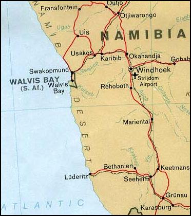
Walvis Bay ( en, lit. Whale Bay; af, Walvisbaai; ger, Walfischbucht or Walfischbai) is a city in Namibia and the name of the bay on which it lies. It is the second largest city in Namibia and the largest coastal city in the country. The city covers a total area of of land. The bay is a safe haven for sea vessels because of its natural deepwater harbour, protected by the Pelican Point sand spit, being the only natural harbour of any size along the country's coast. Being rich in plankton and marine life, these waters also drew large numbers of southern right whales, attracting whalers and fishing vessels. A succession of colonists developed the location and resources of this strategic harbour settlement. The harbour's value in relation to the sea route around the Cape of Good Hope had caught the attention of world powers since it was discovered by the outside world in 1485. This explains the complicated political status of Walvis Bay down the years. The town is situat ... [...More Info...] [...Related Items...] OR: [Wikipedia] [Google] [Baidu] |
Copperbelt
The Copperbelt () is a natural region in Central Africa which sits on the border region between northern Zambia and the southern Democratic Republic of Congo. It is known for copper mining. Traditionally, the term ''Copperbelt'' includes the mining regions of Zambia's Copperbelt Province (notably the towns of Ndola, Kitwe, Chingola, Luanshya, and Mufulira in particular) and the Congo's Haut-Katanga and Lualaba provinces (notably Lubumbashi, Kolwezi, and Likasi). In some contexts the term may exclude the Congo entirely. Zambia's Copperbelt became a province soon after independence in 1964, when it was named "Western province". President Kenneth Kaunda changed the name to its present-day "Copperbelt province" in 1969. From the time of the Bantu expansion, both the Congo's Katanga and Zambia's Copperbelt regions have been called "Ilamba" or "Lambaland", after the Lamba people. Both provinces are rich in mineral wealth. Prehistory The Copperbelt was not inhabited bef ... [...More Info...] [...Related Items...] OR: [Wikipedia] [Google] [Baidu] |
Katima Mulilo Bridge
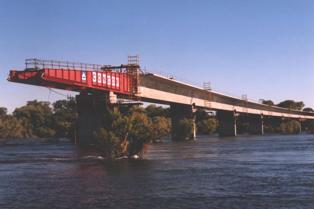
The Katima Mulilo Bridge (also known as ''Bridge 508'' in the Namibian Bridge Register) carries the TransCaprivi Highway over the Zambezi River between Katima Mulilo, Namibia and Sesheke, Zambia. It is a road bridge, completed in 2004, 900 metres long and with 19 spans. It links Namibia's Trans–Caprivi Highway to the Zambian road network, forming a section of the trade route from south-central Africa to the Atlantic known as the Walvis Bay Corridor (Walvis Bay-Ndola-Lubumbashi Development Road). It also carries tourist traffic."COMMISSIONING CEREMONY OF THE KATIMA-MULILO BRIDGE AND THE LIVINGSTONE/SESHEKE ROAD, 13 MAY 2004" Speech of Dr. |
South African Defence Force
The South African Defence Force (SADF) (Afrikaans: ''Suid-Afrikaanse Weermag'') comprised the armed forces of South Africa from 1957 until 1994. Shortly before the state reconstituted itself as a republic in 1961, the former Union Defence Force was officially succeeded by the SADF, which was established by the Defence Act (No. 44) of 1957. The SADF, in turn, was superseded by the South African National Defence Force in 1994. Mission and structure The SADF was organised to perform a dual mission: to counter possible insurgency in all forms, and to maintain a conventional military arm which could defend the republic's borders, making retaliatory strikes as necessary. As the military expanded during the 1970s, the SADF general staff was organised into six sections—finance, intelligence, logistics, operations, personnel, and planning; uniquely, the South African Medical Service (SAMS) was made co-equal with the South African Army, the South African Navy and the South Africa ... [...More Info...] [...Related Items...] OR: [Wikipedia] [Google] [Baidu] |

.jpg)


