|
Karl-Marx-Allee
Karl-Marx-Allee ( en, Karl Marx Alley) is a monumental socialist boulevard built by the GDR between 1952 and 1960 in Berlin Friedrichshain and Mitte. Today the boulevard is named after Karl Marx. It should not be confused with the ''Karl-Marx-Straße'' in the Neukölln district of Berlin. The boulevard was named Stalinallee between 1949 and 1961 (previously ''Große Frankfurter Straße''), and was a flagship building project of East Germany's reconstruction programme after World War II. It was designed by the architects Hermann Henselmann, Hartmann, Hopp, Leucht, Paulick, and Souradny to contain spacious and luxurious apartments for workers, as well as shops, restaurants, cafés, a tourist hotel, and an enormous cinema, the Kino International. The avenue, which is wide and nearly long, is lined with monumental eight-story buildings designed in the wedding-cake style, the socialist classicism of the Soviet Union. At each end are dual towers at Frankfurter Tor and Strausber ... [...More Info...] [...Related Items...] OR: [Wikipedia] [Google] [Baidu] |
Stalin Statue (Berlin)
The Berlin Stalin statue (german: Stalindenkmal) was a bronze portrayal of the Soviet leader Joseph Stalin. A Komsomol delegation had presented the sculpture to the East Berlin government on the occasion of the Third World Festival of Youth and Students in 1951. The monument was formally dedicated on 3 August 1951 after temporary placement at a location on a newly designed and impressive boulevard, Stalinallee, being constructed at the time in what was then the Berlin district of Friedrichshain. Stalin monuments were generally removed from public view by the leadership of the Soviet Union and other associated countries, including East Germany, during the period of De-Stalinization. In Berlin the statue and all street signs designating Stalinallee were hastily removed one night in a clandestine operation and the street was renamed Karl-Marx-Allee and Frankfurter Allee. The bronze sculpture was smashed and the pieces were recycled. Location and description Stalinallee, formerly th ... [...More Info...] [...Related Items...] OR: [Wikipedia] [Google] [Baidu] |
Kino International
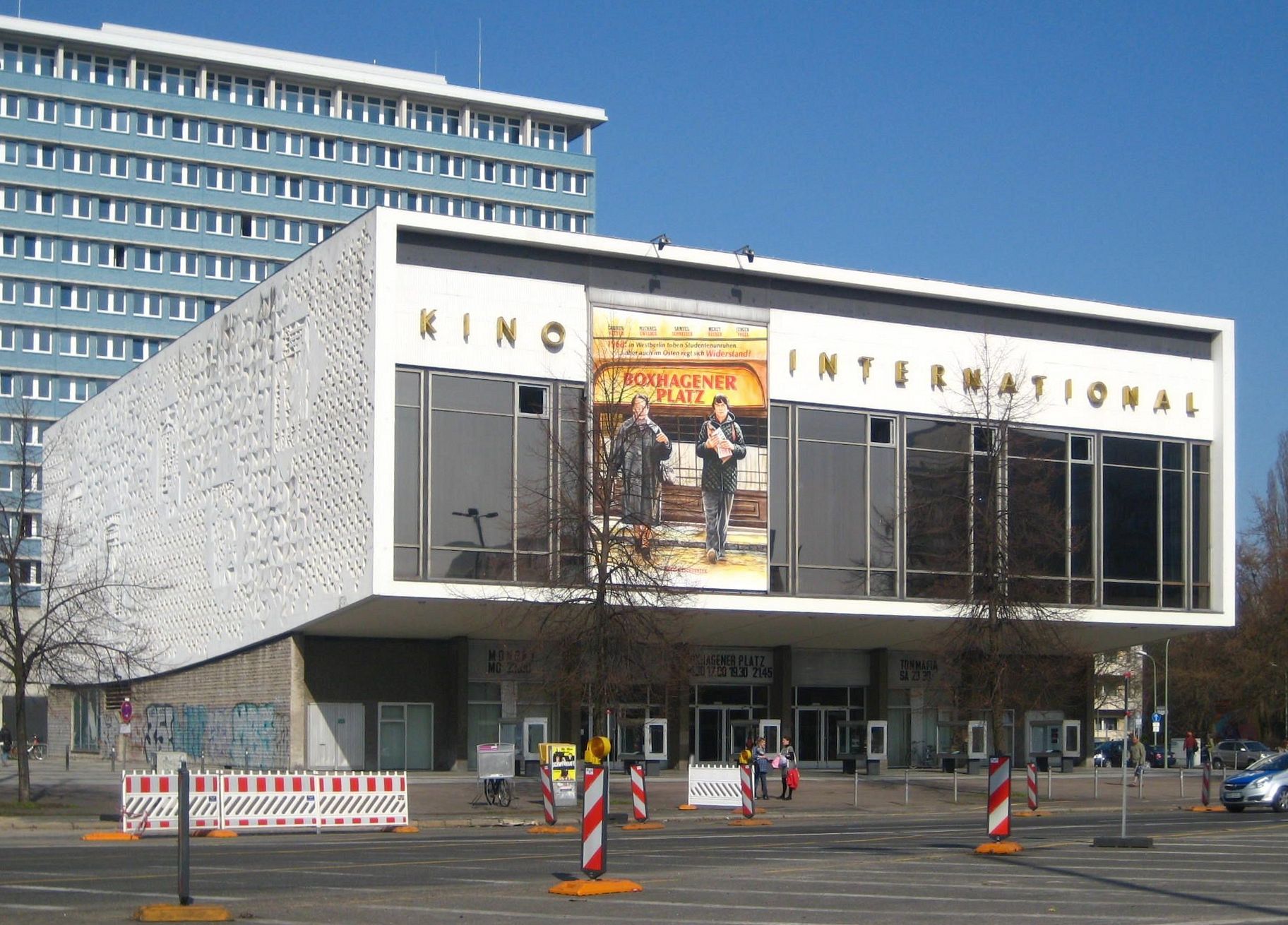
The Kino International is a film theater in Berlin, built from 1961 to 1963. It is located on Karl-Marx-Allee in former East Berlin. It hosted premieres of the DEFA film studios until the fall of the Berlin Wall in 1989. Today it is a protected historic building and one of the venues of the annual Berlin International Film Festival (Berlinale). Karl-Marx-Allee construction After the completion of Karl-Marx-Allee from Strausberger Platz to Proskauer Straße, the next phase (1959–1965) was to extend the street to Alexanderplatz. After the plans of Hermann Henselmann were rejected, a competition was held in which seven architectural firms participated. In contrast to the first phase of construction of the Allee, dominated by the construction of elaborate Socialist Classicist buildings, the second phase included a mixture of Plattenbau, retail stores, restaurants, and cultural facilities according to plans of Edmund Collein, Werner Dutschke, and Josef Kaiser. Retrieved 26 May 201 ... [...More Info...] [...Related Items...] OR: [Wikipedia] [Google] [Baidu] |
Friedrichshain
Friedrichshain () is a quarter (''Ortsteil'') of the borough of Friedrichshain-Kreuzberg in Berlin, Germany. From its creation in 1920 until 2001, it was a freestanding city borough. Formerly part of East Berlin, it is adjacent to Mitte, Prenzlauer Berg, Kreuzberg and Lichtenberg. Friedrichshain is named after the ''Volkspark Friedrichshain'', a vast green park at the northern border with Prenzlauer Berg. In the Nazi era, the borough was called '' Horst-Wessel-Stadt''. Friedrichshain is one of the trendy districts of Berlin and has experienced gentrification. Geography Friedrichshain is defined by the following roads and places, starting clock-wise in the west: Lichtenberger Straße, Mollstraße, Otto-Braun-Straße, Am Friedrichshain, Virchowstraße, Margarete-Sommer-Straße, Danziger Straße, Landsberger Allee, Hausburgstraße, Thaerstraße, Eldenaer Straße, S-Bahn-Trasse, Kynaststraße, Stralauer Halbinsel, Spree. History The largely working-class district was created in ... [...More Info...] [...Related Items...] OR: [Wikipedia] [Google] [Baidu] |
Hermann Henselmann
Hermann Henselmann (3 February 1905 – 19 January 1995) was a German architect most famous for his buildings constructed in East Germany during the 1950s and 1960s. Early years Henselmann was born in Roßla and studied at the Kunstgewerbeschule in Berlin from 1922 to 1925. His early projects, such as a house on Lake Geneva near Montreux (1930) were Modernist in style, showing a clear Bauhaus influence, and due to this and Henselmann's partly Jewish ancestry he was prevented from working as a private architect by the Nazi government. Socialist Realism After the war he was appointed head architect in the city of Gotha and later in Weimar in the Soviet Zone of Germany, although his projects were subjected to harsh criticism for their Modernism. He served in Hans Scharoun's town planning group that tried to convert the Socialist Unity Party of Germany's leaders to Modernism, although unlike Scharoun, Henselmann stayed in East Berlin after their rejection. His neo-classical Weberw ... [...More Info...] [...Related Items...] OR: [Wikipedia] [Google] [Baidu] |
Frankfurter Tor
The Frankfurter Tor ("Frankfurt Gate") is a large square in the inner-city Friedrichshain locality of Berlin. It is situated in the centre of the district, at the intersection of Karl-Marx-Allee and Frankfurter Allee (the eastbound federal highways No. 1 and No. 5) with the Warschauer Straße and Petersburger Straße ring road (federal highway No. 96a). The Frankfurter Tor station, on the city's U-Bahn line , is located under the square. History The previously unnamed square received the name "Frankfurter Tor" on 8 November 1957 in the course of its reconstruction after World War II. The designation recalls both the historic city gate of the Berlin Customs Wall, providing access to the road to the city of Frankfurt (Oder), as well as two former street names, Große Frankfurter Straße and Frankfurter Allee, for the Wilhelmine east–west axis of the major intersection at this location. The original location of the gate, however, was approximately west of today's Frankfurter ... [...More Info...] [...Related Items...] OR: [Wikipedia] [Google] [Baidu] |
Egon Hartmann
Egon Hartmann (24 August 1919 – 6 December 2009) was a German architect and city planner who won prizes for his city planning concepts for both East and West Berlin. Early life and education Egon Hartmann was born on 24 August 1919 in Reichenberg (Liberec), Czechoslovakia. After graduating from the ''Staatsgewerbeschule'' technical high school in 1938, he moved to Berlin to work for the architect Henry König. However, he was drafted into the army in January 1939 and was among the troops that entered Prague during the invasion of Czechoslovakia in March 1939. While injured and on medical leave from the army, he started studying at Bauhaus University, Weimar in winter 1942/43. In late 1944, he was severely wounded in the Courland Pocket, and lost his lower jaw, which made him undergo 48 surgeries and caused him problems for the rest of his life. He resumed his studies in Weimar in 1946, graduating in 1948. In 1962, he obtained a doctoral degree from TH Darmstadt with a thesis ... [...More Info...] [...Related Items...] OR: [Wikipedia] [Google] [Baidu] |
U5 (Berlin U-Bahn)
U5 is a line on the Berlin U-Bahn. It runs from Hauptbahnhof in Mitte eastwards through Alexanderplatz, Friedrichshain, Lichtenberg and Friedrichsfelde, surfaces in to pass Kaulsdorf and Hellersdorf above ground and finally reaches city limits at Hönow. Route Line U5 connects Moabit with the large housing estate of Hellersdorf and the Brandenburg town of Hönow, but ends just outside the eastern city limits of Berlin. It begins at Berlin Hauptbahnhof (central station) and heads southeast under the Spree river, the Spreebogenpark and the Platz der Republik to Brandenburg Gate. From there it follows Unter den Linden, crossing line 6 at Friedrichstraße. After Museumsinsel station, the line runs under Rathausstraße, passing under the Humboldt Forum. After leaving Alexanderplatz, it takes a sharp right turn under Karl-Marx-Allee. It follows that street (which becomes Frankfurter Allee after Frankfurter Tor station) for several stations in a straight line in an easterly directi ... [...More Info...] [...Related Items...] OR: [Wikipedia] [Google] [Baidu] |
Mitte
Mitte () is the first and most central borough of Berlin. The borough consists of six sub-entities: Mitte proper, Gesundbrunnen, Hansaviertel, Moabit, Tiergarten and Wedding. It is one of the two boroughs (the other being Friedrichshain-Kreuzberg) which were formerly divided between East Berlin and West Berlin. Mitte encompasses Berlin's historic core and includes some of the most important tourist sites of Berlin like the Reichstag and Berlin Hauptbahnhof, Checkpoint Charlie, Museum Island, the TV tower, Brandenburg Gate, Unter den Linden, Potsdamer Platz, Alexanderplatz, the latter six of which were in former East Berlin. Geography Mitte (German for "middle", "centre") is located in the central part of Berlin along the Spree River. It borders on Charlottenburg-Wilmersdorf in the west, Reinickendorf in the north, Pankow in the east, Friedrichshain-Kreuzberg in the southeast, and Tempelhof-Schöneberg in the southwest. In the middle of the Spree lies Museum Island (''Museum ... [...More Info...] [...Related Items...] OR: [Wikipedia] [Google] [Baidu] |
Boulevard
A boulevard is a type of broad avenue planted with rows of trees, or in parts of North America, any urban highway. Boulevards were originally circumferential roads following the line of former city walls. In American usage, boulevards may be wide, multi-lane arterial thoroughfares, often divided with a central median, and perhaps with side-streets along each side designed as slow travel and parking lanes and for bicycle and pedestrian usage, often with an above-average quality of landscaping and scenery. Etymology The word ''boulevard'' is borrowed from French. In French, it originally meant the flat surface of a rampart, and later a promenade taking the place of a demolished fortification. It is a borrowing from the Dutch word ' 'bulwark'. Usage world-wide Asia Cambodia Phnom Penh has numerous boulevards scattered throughout the city. Norodom Boulevard, Monivong Boulevard, Sihanouk Boulevard, and Kampuchea Krom Boulevard are the most famous. India * Bengaluru's Maha ... [...More Info...] [...Related Items...] OR: [Wikipedia] [Google] [Baidu] |
De-Stalinization
De-Stalinization (russian: десталинизация, translit=destalinizatsiya) comprised a series of political reforms in the Soviet Union after the death of long-time leader Joseph Stalin in 1953, and the thaw brought about by ascension of Nikita Khrushchev to power, and his 1956 secret speech On the Cult of Personality and Its Consequences, which denounced Stalin's cult of personality and the Stalinist political system. Monuments to Stalin were removed or toppled, his name was removed from places, buildings, and the state anthem, and his body was removed from the Lenin Mausoleum (from 1953 to 1961 known as Lenin and Stalin Mausoleum) and buried. These reforms were started by the collective leadership which succeeded him after his death on 5 March 1953, comprising Georgi Malenkov, Premier of the Soviet Union; Lavrentiy Beria, head of the Ministry of the Interior; and Nikita Khrushchev, First Secretary of the Central Committee of the Communist Party of the Soviet ... [...More Info...] [...Related Items...] OR: [Wikipedia] [Google] [Baidu] |
Berlin Karlmarxallee Kl
Berlin is the capital and largest city of Germany, both by area and by population. Its more than 3.85 million inhabitants make it the European Union's most populous city, as measured by population within city limits having gained this status after the United Kingdom's, and thus London's, departure from the European Union. Simultaneously, the city is one of the states of Germany, and is the third smallest state in the country in terms of area. Berlin is surrounded by the state of Brandenburg, and Brandenburg's capital Potsdam is nearby. The urban area of Berlin has a population of over 4.5 million and is therefore the most populous urban area in Germany. The Berlin-Brandenburg capital region has around 6.2 million inhabitants and is Germany's second-largest metropolitan region after the Rhine-Ruhr region, and the fifth-biggest metropolitan region by GDP in the European Union. Berlin was built along the banks of the Spree river, which flows into the Havel in the western bor ... [...More Info...] [...Related Items...] OR: [Wikipedia] [Google] [Baidu] |


.jpg)


