|
Kaokoland
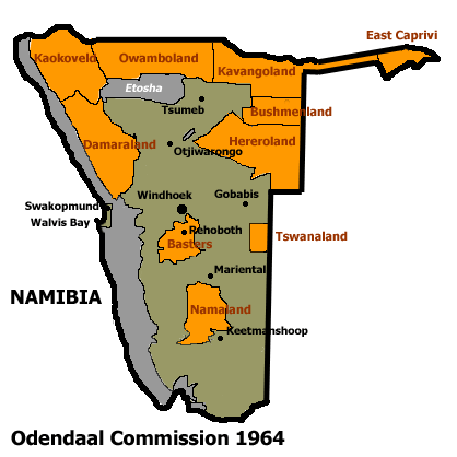
Kaokoland was an administrative unit and a ''bantustan'' in northern South West Africa (now Namibia). Established during the apartheid era, it was intended to be a self-governing homeland of the OvaHimba, but an actual government was never established. Like other homelands in South West Africa, the Kaokoland bantustan was abolished in May 1989, at the beginning of the transition of Namibia towards independence. "Kaokoland" remains as an informal name for the geographic area, while the political unit of administration since 1990 is Kunene Region. The area is in the Kaokoveld ecoregion. The area is one of the wildest and least populated areas in Namibia, with a population density of one person every 2 km² (1/4 of the national average). The most represented ethnic group is the Himba people, who account for about 5,000 of the overall 16,000 inhabitants of Kaokoland. The main settlement in Kaokoland was the city of Opuwo. Geography The Kaokoland area extends south-north ... [...More Info...] [...Related Items...] OR: [Wikipedia] [Google] [Baidu] |
Himba People
The Himba (singular: OmuHimba, plural: OvaHimba) are an indigenous people with an estimated population of about 50,000 people living in northern Namibia, in the Kunene Region (formerly Kaokoland) and on the other side of the Kunene River in southern Angola. There are also a few groups left of the OvaTwa, who are also OvaHimba, but are hunter-gatherers. Culturally distinguishable from the Herero people, the OvaHimba are a semi-nomadic, pastoralist people and speak OtjiHimba, a variety of Herero, which belongs to the Bantu family within Niger–Congo. The OvaHimba are semi-nomadic as they have base homesteads where crops are cultivated, but may have to move within the year depending on rainfall and where there is access to water. The OvaHimba are considered the last (semi-) nomadic people of Namibia. Culture Subsistence economy The OvaHimba are predominantly livestock farmers who breed fat-tailed sheep and goats, but count their wealth in the number of their cattle. They ... [...More Info...] [...Related Items...] OR: [Wikipedia] [Google] [Baidu] |
Bantustan
A Bantustan (also known as Bantu homeland, black homeland, black state or simply homeland; ) was a territory that the National Party administration of South Africa set aside for black inhabitants of South Africa and South West Africa (now Namibia), as part of its policy of apartheid. By extension, outside South Africa the term refers to regions that lack any real legitimacy, consisting often of several unconnected enclaves, or which have emerged from national or international gerrymandering.Macmillan DictionaryBantustan, "1. one of the areas in South Africa where black people lived during the apartheid system; 2. SHOWING DISAPPROVAL any area where people are forced to live without full civil and political rights." The term, first used in the late 1940s, was coined from Bantu' (meaning "people" in some of the Bantu languages) and ''-stan'' (a suffix meaning "land" in the Persian language and some Persian-influenced languages of western, central, and southern Asia). It subs ... [...More Info...] [...Related Items...] OR: [Wikipedia] [Google] [Baidu] |
Kunene Region
Kunene is one of the fourteen regions of Namibia. Its capital is Opuwo, its governor is Marius Sheya. The region's name comes from the Kunene River which forms the northern border with Angola. Besides the capital Opuwo, the region contains the municipality of Outjo, the town Khorixas and the self-governed village Kamanjab. Kunene is home to the Himba people, a subtribe of the Herero. , Kunene had 58,548 registered voters. Kunene's western edge is the shores of the Atlantic Ocean. In the north, it borders Angola's Namibe Province, and in the far eastern part of its northern edge it borders Cunene Province. Domestically, it borders the following regions: * Omusati - northeast, west of Oshana * Oshana - northeast, between Omusati and Oshikoto *Oshikoto - northeast, east of Oshikoto *Otjozondjupa - east * Erongo - south Politics The region comprises seven constituencies: * Epupa * Kamanjab * Khorixas * Opuwo Rural * Opuwo Urban * Outjo * Sesfontein Kunene is one of ... [...More Info...] [...Related Items...] OR: [Wikipedia] [Google] [Baidu] |
South West Africa
South West Africa ( af, Suidwes-Afrika; german: Südwestafrika; nl, Zuidwest-Afrika) was a territory under South African administration from 1915 to 1990, after which it became modern-day Namibia. It bordered Angola ( Portuguese colony before 1975), Botswana ( Bechuanaland before 1966), South Africa, and Zambia (Northern Rhodesia before 1964). Previously the German colony of South West Africa from 1884–1915, it was made a League of Nations mandate of the Union of South Africa following Germany's defeat in the First World War. Although the mandate was abolished by the United Nations in 1966, South African control over the territory continued despite its illegality under international law. The territory was administered directly by the South African government from 1915 to 1978, when the Turnhalle Constitutional Conference laid the groundwork for semi-autonomous rule. During an interim period between 1978 and 1985, South Africa gradually granted South West Africa a limited ... [...More Info...] [...Related Items...] OR: [Wikipedia] [Google] [Baidu] |
Herero People
The Herero ( hz, Ovaherero) are a Bantu ethnic group inhabiting parts of Southern Africa. There were an estimated 250,000 Herero people in Namibia in 2013. They speak Otjiherero, a Bantu language. Though the Herero primarily reside in Namibia, there are also significant populations in Botswana and Angola. In Botswana, the Hereros or Ovaherero are mostly found in Maun and some villages surrounding Maun. These villages among others are Sepopa, Toromuja, Karee and Etsha. Some of them are at Mahalapye. In the South eastern part of Botswana they are at Pilane. There are also a few of them in the Kgalagadi South, that is Tsabong, Omawaneni, Draaihoek and Makopong Villages. Overview Unlike most Bantu, who are primarily subsistence farmers,Immaculate N. Kizza, ''The Oral Tradition of the Baganda of Uganda: A Study and Anthology of Legends, Myths, Epigrams and Folktales'' p. 21: "The Bantu were, and still are, primarily subsistence farmers who would settle in areas, clear land, ... [...More Info...] [...Related Items...] OR: [Wikipedia] [Google] [Baidu] |
Epupa Falls
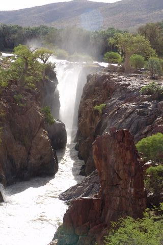
Epupa Falls (also known as Monte Negro Falls in Angola) is a series of large waterfalls formed by the Cunene River on the border of Angola and Namibia, in the Kaokoland area of the Kunene Region. The river is about wide in this area and drops in a series of waterfalls across a length of , with the greatest single drop being in height. The settlement near the falls is also called Epupa. The name "Epupa" is a Herero word for "foam", in reference to the foam created by the falling water. The Epupa Constituency is named for the falls. Ecology Due to the specialised nature of this steep riparian habitat, the Epupa Falls are the locus of endemism for a number of fish and other aquatic species. Access Despite being difficult to reach (a four-wheel drive vehicle is recommended to reach them from Opuwo), the falls are a major visitor attraction in Namibia because of the largely unspoiled environment, with fig trees, baobabs, makalani palms, and coloured rock walls framing the falls. ... [...More Info...] [...Related Items...] OR: [Wikipedia] [Google] [Baidu] |
Kaokoveld
The Kaokoveld Desert is a coastal desert of northern Namibia and southern Angola. Setting The Kaokoveld Desert occupies a coastal strip covering , from 13° to 21°S and is bounded by the Atlantic Ocean to the west, the Namibian savanna woodlands to the east, and the Namib Desert to the south. It includes the Moçâmedes Desert of southern Angola. The Kaokoveld is a harsh desert of drifting sandunes and rocky mountains. It receives most of its rainfall during the summer, which distinguishes it from the adjacent Namib Desert to the south, which receives most of its rain during the winter. The Kunene River is the only permanent watercourse but many dry riverbeds (including the Hoanib, Hoarusib and Khumib Rivers) carry moisture through the desert and are home to animals including elephants, black rhinos, and giraffe. Other than those the area is ancient desert sand, moistened by occasional coastal fog. Flora The Kaokoveld is home to '' Welwitschia mirabilis'', a plant that has ... [...More Info...] [...Related Items...] OR: [Wikipedia] [Google] [Baidu] |
Hoanib
The Hoanib is one of the 12 ephemeral seasonal rivers in the west of Namibia, where it was the border between northern Damaraland and Kaokoland. Its length is 270 km. With the low population density, the oasis character of the river valley and the relatively high wildlife population of Hoanib, together with the Hoarusib its valley is one of the last true wilderness areas in Namibia, one of the last settlements of desert elephants and shows strong wind and water eroded and weathered stone deposits (up to 10 m height). Inflows of Hoanib are Aap River, Otjitaimo River, Ombonde, Ganamub, Mudorib and Tsuxub. Hydrology The Hoanib's catchment area (including its tributaries) is estimated to be between 15760 and . It extends from the west coast to Ojiovasando and the Black Peaks of the interior. It also includes the resource-rich region Sesfontein, Warmquelle and the Khowarib Gorge. The highest point of the watershed is at 1800 m. The rainfall in the catchment area is spora ... [...More Info...] [...Related Items...] OR: [Wikipedia] [Google] [Baidu] |
Kunene River
The Cunene (Portuguese spelling) or Kunene (common Namibian spelling) is a river in Southern Africa. It flows from the Angola highlands south to the border with Namibia. It then flows west along the border until it reaches the Atlantic Ocean. It is one of the few perennial rivers in the region. It is about long, with a drainage basin in area. Its mean annual discharge is 174 m3/s (6,145 cfs) at its mouth. The Epupa Falls lie on the river. Olushandja Dam dams a tributary of the river, the Etaka, and helps provide the Ruacana Power Station with water. Dam controversies The Namibian government proposed in the late 1990s to build the Epupa Dam, a controversial hydroelectric dam on the Cunene. In 2012 the Governments of Namibia and Angola announced plans to jointly build the Orokawe dam in the Baynes Mountains. According to the indigenous Himba who would have been most affected by the construction of the dam, the dam threatens the local ecosystem and therefore the economic ba ... [...More Info...] [...Related Items...] OR: [Wikipedia] [Google] [Baidu] |
Opuwo
Opuwo is the capital of the Kunene Region in north-western Namibia. The town is situated about 720 km north-northwest from the capital Windhoek, and has a population of 20,000. It is the commercial hub of the Kunene Region. Economy and infrastructure Opuwo is situated at the intersection of the C41 and C43. There is a small airfield in town, Opuwo Airport. Putuavanga Senior Secondary School in town is among the best government schools in Kunene Region. There is also the ''Opuwo Primary School'' 39 teachers and 1,200 learners. There are the following organizations and offices in the town: Opuwo Police Station, Opuwo District Hospital, Ministry of Home Affairs (Department of Civic Affairs / Regional Civic Registration Office / Kunene Region) and Opuwo Department of Works. There is a Christian church. Politics Opuwo is governed by a town council that has seven seats. The 2015 local authority election was narrowly won by the SWAPO party, which gained four seats (1,593 ... [...More Info...] [...Related Items...] OR: [Wikipedia] [Google] [Baidu] |


_Mud_hut.jpg)

