|
Kantō Plain
The is the largest plain in Japan, and is located in the Kantō region of central Honshū. The total area of 17,000 km2 covers more than half of the region extending over Tokyo, Saitama Prefecture, Kanagawa Prefecture, Chiba Prefecture, Gunma Prefecture, Tochigi Prefecture and Ibaraki Prefecture. Geography The northern limit borders on the Abukuma Highlands, Yamizo Mountain Range, Ashio Mountain Range, and a volcanic field associated with the Nasu Volcanic Belt. The western coincides with the Kantō Mountain Range and the southern edge is defined by the Bōsō Peninsula, the Miura Hills, Tokyo Bay, and Sagami Bay. The Kashima Sea and Kujūkuri Beach define the eastern end of the plain. Most of the rivers originate in the northern or western mountain ranges and flow east or southeast into the Pacific Ocean, Tokyo Bay, or Sagami Bay. In the central part of the plain is the Tone River; in the northern part the Watarase River, Kinu River, Kokai River, Naka Ri ... [...More Info...] [...Related Items...] OR: [Wikipedia] [Google] [Baidu] |
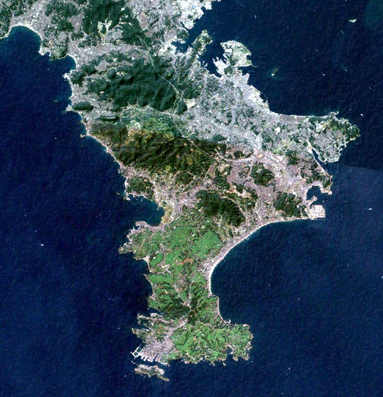
Miura Peninsula
is a peninsula located in Kanagawa, Japan. It lies south of Yokohama and Tokyo and divides Tokyo Bay, to the east, from Sagami Bay, to the west. Cities and towns on the Miura Peninsula include Yokosuka, Miura, Hayama, Zushi, and Kamakura. The northern limit of the peninsula runs from Koshigoe, Kamakura in the west, across to Mt. Enkai, in the southern wards of Yokohama in the east, overlooking Tokyo Bay. Overview The peninsula is a bedroom community for those who work in Tokyo and a popular tourist destination for people from Tokyo. It is also an important area for Japan's self-defense, with the eastern side hosting the National Defense Academy of Japan National may refer to: Common uses * Nation or country ** Nationality – a ''national'' is a person who is subject to a nation, regardless of whether the person has full rights as a citizen Places in the United States * National, Maryland, ce ... and the Yokosuka Naval Base, serving both the Japanese Maritime ... [...More Info...] [...Related Items...] OR: [Wikipedia] [Google] [Baidu] |
Musashino Plateau
The , also translated as Musashino Platform and also named as Musashino Region, is a large tableland (known as a fluvial terrace) in the Kantō region of Honshu, Japan. The Musashino Plateau is a plateau that extends between the Arakawa and Tama Rivers. Origin It consists of an alluvial fan formed by the ancient Tama River with a layer of volcanic ash on top, many meters deep. The Tama River, which flowed downward as it carved the Okutama Mountains, formed a large alluvial fan with Ōme as the top of the fan. This alluvial fan is the base of the Musashino Plateau, and on it the Kantō Loam Formation is deposited with a thickness of approximately 5 to 15 meters. The Kantō Loam Formation is primarily andesite or basaltic sandy mud that was formed by volcanic ash from Mount Fuji that was carried by the west wind and deposited. Terraces Two types of developed river terraces can be seen on the Musashino Plateau. One is formed by the Tama River flowing on the south side, and the low ... [...More Info...] [...Related Items...] OR: [Wikipedia] [Google] [Baidu] |
Sagami River
The is a river in Kanagawa and Yamanashi Prefectures on the island of Honshū, Japan. The upper reaches of the river in Yamanashi prefecture are also sometimes known as the , and the portion near the river mouth as the . The river overall was sometimes referred to as the from the sweetfish (''ayu'') which were once abundant in its waters. The Sagami River drains Lake Yamanaka, the largest and easternmost of the Fuji Five Lakes in Yamanashi Prefecture. It loops northwest, then northeast through Yamanashi, before following a generally southerly course to exit into Sagami Bay of the Pacific Ocean between the cities of Hiratsuka and Chigasaki. It is dammed at several locations along the way, forming a number of reservoir lakes, the largest of which are Lake Sagami and Lake Tsukui. The river has had to re-cut its course several times due to repeated eruptions of Mount Fuji, and river terraces are in evidence along its upper reaches in Yamanashi. As the river crosses Kanagawa, it ... [...More Info...] [...Related Items...] OR: [Wikipedia] [Google] [Baidu] |
Tama River
The is a major river in Yamanashi, Kanagawa and Tokyo Prefectures on Honshū, Japan. It is officially classified as a Class 1 river by the Japanese government. Its total length is , and the total of the river's basin area spans . The river flows through Tokyo, on the dividing line between Tokyo and Kanagawa. In the city, its banks are lined with parks and sports fields, making the river a popular picnic spot. Course The Tama's source is located at Mt. Kasatori in Koshu in Yamanashi Prefecture. From there, it flows eastward into mountainous western Tokyo, where the Ogōchi Dam forms Lake Okutama. Below the dam, it takes the name Tama and flows eastwards through Chichibu Tama Kai National Park towards Ōme, Tokyo. It then flows southeast between Tama Hills and Musashino Terrace. At Hamura is the source of the historic Tamagawa Aqueduct built by the Tamagawa brothers in 1653 to supply water to Edo (present day Tokyo). Further downstream, the river forms the boundary ... [...More Info...] [...Related Items...] OR: [Wikipedia] [Google] [Baidu] |
Arakawa River (Kantō)
The is a long river that flows through Saitama Prefecture and Tokyo. Its average flow in 2002 was 30m³/s. It originates on Mount Kobushi in Saitama Prefecture, and empties into Tokyo Bay. It has a total catchment area of . The river is one of Tokyo's major sources of tap water, and together with the Tone River, accounts for around 80% of Tokyo's water supply as of 2018. The Okubo water purification plant takes water from the river. History Attempts to control flooding of the Arakawa River have been made since the area that is now Tokyo became the de facto capital of Japan during the Edo period. Following a major flood in 1910 that damaged a large part of central Tokyo, a long drainage canal was constructed between 1911 and 1924. In 1996 an agreement was signed to make it a "sister river" of the Potomac River in the eastern United States. This means that officials and volunteers from both river areas collaborate with each other. Media This river is also depicted in many anim ... [...More Info...] [...Related Items...] OR: [Wikipedia] [Google] [Baidu] |
Kuji River
is a river in Fukushima Prefecture, Tochigi Prefecture and Ibaraki Prefecture, Japan. It rises at the northern slope of Mount Yamizo, where the border of these three prefectures is located, and flows into Pacific Ocean at Hitachi and Tokai in Ibaraki Prefecture. It has a length of and a drainage area of , and is designated as a Class A river. The name of ''Kuji'' is thought to have been named after whale (''kujira'' in Japanese). ', one of the existent ''Fudoki'', says, "There were a hill that resembled a whale (''kujira''). Then the emperor named the land ''Kuji''." The river is known for ayu fishing, and in 2006 it had the second largest catch of ayu in Japan after Naka River, which is also located in Ibaraki Prefecture. The fishing weir (梁 ''yana'') for tourists is installed along the river in Daigo. Famous Fukuroda Falls are located on Taki River (滝川 ''Takigawa''), which is one of its tributary rivers. On midwinter a phenomenon called ' can be observed in the riv ... [...More Info...] [...Related Items...] OR: [Wikipedia] [Google] [Baidu] |
Naka River (Tochigi Ibaraki)
The is a river in eastern Honshu, Japan. It flows through the prefectures of Tochigi and Ibaraki and empties to the Pacific Ocean. More than 50 species of fish live in the river, including dace, chum salmon, ayu, and herring. The Japanese government categorizes it as a Class 1 river. With a length of , the Naka drains an area of , including parts of neighboring Fukushima Prefecture. Its source is at Nasu-dake in Nikkō National Park is a national park in the Kantō region, on the main island of Honshū in Japan. The park spreads over three prefectures: Tochigi, Gunma and Fukushima, and was established in 1934. History The establishment of Nikkō National Park dates to t .... Naming * References * ''Spring Comes with the Arrival of Dace - Naka River'', NHK 1998 External links (mouth) Rivers of Tochigi Prefecture Rivers of Ibaraki Prefecture Rivers of Fukushima Prefecture Rivers of Japan {{Japan-river-stub ... [...More Info...] [...Related Items...] OR: [Wikipedia] [Google] [Baidu] |
Kinu River
, is a river on the main island of Honshu in Japan. It flows from the north to the south on the Kantō plain, merging with . At 176.7 km in length, it is the longest tributary of Tone-gawa. From ancient times, it has been known to cause floods. The river starts in Kinu swamp in the city of Nikkō, Tochigi, within Nikkō National Park. See also * Kinugawa Onsen, a spa town A spa town is a resort town based on a mineral spa (a developed mineral spring). Patrons visit spas to "take the waters" for their purported health benefits. Thomas Guidott set up a medical practice in the English town of Bath, Somerset, B ... within Nikkō * Keno Province External links (confluence with Tone River) Rivers of Ibaraki Prefecture Rivers of Tochigi Prefecture Rivers of Japan {{Japan-river-stub ... [...More Info...] [...Related Items...] OR: [Wikipedia] [Google] [Baidu] |
Watarase River
The is a major river in the northern Kantō region of Japan. A tributary of the Tone River, it is in length and drains an area of . ( official page) (Retrieved on June 29, 2009) Its source is at Mount Sukai on the boundary of the city of |
Tone River
The is a river in the Kantō region of Japan. It is in length (the second longest in Japan after the Shinano) and has a drainage area of (the largest in Japan). It is nicknamed Bandō Tarō (); ''Bandō'' is an obsolete alias of the Kantō Region, and ''Tarō'' is a popular given name for an oldest son. It is regarded as one of the "Three Greatest Rivers" of Japan, the others being the Yoshino in Shikoku and the Chikugo in Kyūshū. Geography The source of the Tone River is at () () in the Echigo Mountains, which straddle the border between Gunma and Niigata Prefectures in Jōshin'etsu Kōgen National Park. The Tone gathers tributaries and pours into the Pacific Ocean at Cape Inubō, Choshi in Chiba Prefecture. Tributaries Major tributaries of the Tone River include the Agatsuma, Watarase, Kinu, Omoi, and the . The Edo River branches away from the river and flows into Tokyo Bay. History The Tone River was once known for its uncontrollable nature, ... [...More Info...] [...Related Items...] OR: [Wikipedia] [Google] [Baidu] |
Pacific Ocean
The Pacific Ocean is the largest and deepest of Earth's five oceanic divisions. It extends from the Arctic Ocean in the north to the Southern Ocean (or, depending on definition, to Antarctica) in the south, and is bounded by the continents of Asia and Oceania in the west and the Americas in the east. At in area (as defined with a southern Antarctic border), this largest division of the World Ocean—and, in turn, the hydrosphere—covers about 46% of Earth's water surface and about 32% of its total surface area, larger than Earth's entire land area combined .Pacific Ocean . '' Britannica Concise.'' 2008: Encyclopædia Britannica, Inc. The centers of both the [...More Info...] [...Related Items...] OR: [Wikipedia] [Google] [Baidu] |


.jpg)