|
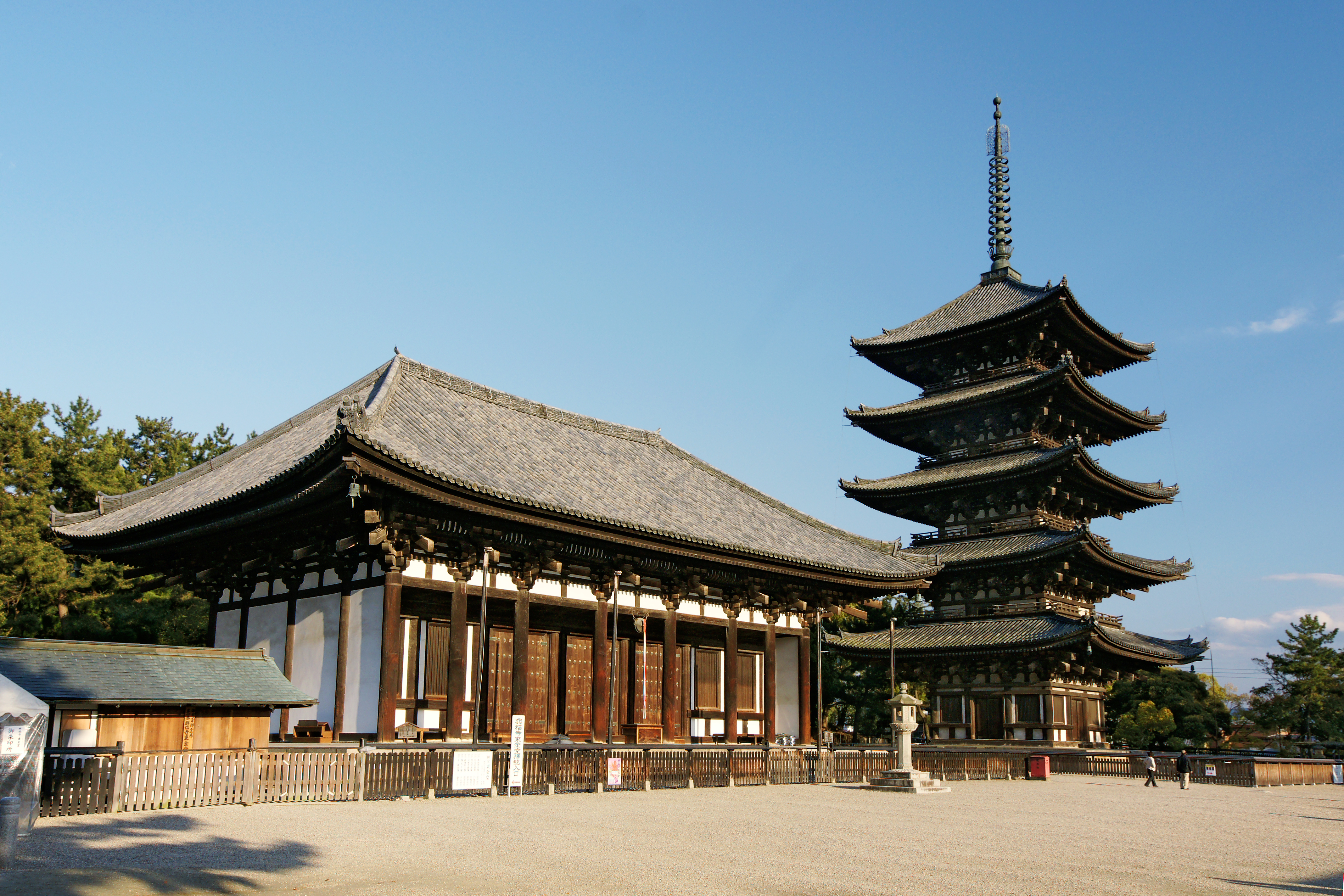
Kamikitayama, Nara
is a village located in Yoshino District, Nara Prefecture, Japan. As of October 1, 2016, the village has an estimated population of 486. The total area is 274.05 km2. The village has an aging population. Between 2002 and 2007 the population declined by 15.6%. This trend has continued. It is one of the villages expected to be extinct by 2040. Geography Neighboring municipalities * Nara Prefecture ** Shimokitayama ** Gojō ** Totsukawa ** Kawakami ** Tenkawa * Mie Prefecture ** Kumano ** Owase ** Ōdai ** Kihoku Climate Kamikitayama has a humid subtropical climate (Köppen climate classification ''Cfa'') with hot summers and cool to cold winters. Precipitation is significantly higher in summer than in winter, though on the whole lower than most parts of Honshū, and there is no significant snowfall. The average annual temperature in Kamikitayama is . The average annual rainfall is with September as the wettest month. The temperatures are highest on average in August, ... [...More Info...] [...Related Items...] OR: [Wikipedia] [Google] [Baidu] |
Nara Prefecture
is a prefecture of Japan located in the Kansai region of Honshu. Nara Prefecture has a population of 1,321,805 and has a geographic area of . Nara Prefecture borders Kyoto Prefecture to the north, Osaka Prefecture to the northwest, Wakayama Prefecture to the southwest, and Mie Prefecture to the east. Nara is the capital and largest city of Nara Prefecture, with other major cities including Kashihara, Ikoma, and Yamatokōriyama. Nara Prefecture is located in the center of the Kii Peninsula on Japan's Pacific Ocean coast, and is one of only eight landlocked prefectures. Nara Prefecture has the distinction of having more UNESCO World Heritage listings than any other prefecture in Japan. History Nara Prefecture region is considered one of the oldest regions in Japan, having been in existence for thousands of years, and is widely viewed as the Japanese cradle of civilization. Like Kyoto, Nara was one of Imperial Japan's earliest capital cities. The current form of Nara Prefec ... [...More Info...] [...Related Items...] OR: [Wikipedia] [Google] [Baidu] |
Totsukawa, Nara
is a village located in Yoshino District, Nara Prefecture, Japan. It is the largest village in Japan in terms of area. As of January 2017, the village has an estimated population of 3,488 and a density of 5.2 persons per km2. The total area is 672.35 km2. History In 1889, a major flood happened in Totsukawa, causing widespread destruction. In result, many citizens moved to Hokkaido and developed a new village there. It was named “ Shintotsukawa”, meaning “New Totsukawa" . Geography Climate Totsukawa has a humid subtropical climate (Köppen climate classification ''Cfa''), which is hot and humid in the summer (above ) and is somewhat cold in the winter with temperatures dropping to around freezing () Demographics Per Japanese census data, the population of Totsukawa in 2020 is 3,061 people. Totsukawa has been conducting censuses since 1920. Landmarks * Tanize Suspension Bridge (谷瀬の吊り橋): a suspension bridge known for the ''Yuredaiko'', an annual drum ... [...More Info...] [...Related Items...] OR: [Wikipedia] [Google] [Baidu] |
JET Programme
The , or , is a Japanese government initiative that brings college (university) graduates—mostly native speakers of English—to Japan as Assistant Language Teachers (ALTs) and Sports Education Advisors (SEAs) in Japanese kindergartens, elementary, junior high and high schools, or as Coordinators for International Relations (CIRs) in local governments and boards of education. JET Programme participants are collectively called JETs. Participants currently come from a total of 40 countries. As of July 1, 2014, 4,476 participants (in CIR, ALT, and SEA positions) were employed on the programme, making it the world's largest exchange teaching programme. Of that number, about half are from the United States (2,457), with Canada (495), the United Kingdom (383), Australia (315), New Zealand (255), South Africa (93), and Ireland (86) making up the majority of JET participants. Holders of Japanese passports may participate in the programme, but must renounce their Japanese citizenship to d ... [...More Info...] [...Related Items...] OR: [Wikipedia] [Google] [Baidu] |
Assistant Language Teacher
An Assistant Language Teacher (ALT) is a foreign national serving as an assistant teacher (paraprofessional educator) in a Japanese classroom, particularly for English. The term was created by the Japanese Ministry of Education at the time of the creation of the JET Programme as a translation of the term 外国語指導助手 (''gaikokugo shidō joshu'') or literally "foreign language instruction assistant". The terms AET (Assistant English Teacher), ELT (English Language Teacher) and NESA (Native English Speaking Assistant) are also in use. The term is used by the Ministry of Education, local Boards of Education (BOEs) and schools in Japan primarily to refer to English language speakers who assist with teaching of English in elementary, junior high and senior high schools. However, some ALTs help teach languages other than English. ALTs are typically required to be university graduates, but they are usually not certified teachers like their Japanese colleagues. However, applicant ... [...More Info...] [...Related Items...] OR: [Wikipedia] [Google] [Baidu] |
Junior High Schools
A middle school (also known as intermediate school, junior high school, junior secondary school, or lower secondary school) is an educational stage which exists in some countries, providing education between primary school and secondary school. The concept, regulation and classification of middle schools, as well as the ages covered, vary between and sometimes within countries. Afghanistan In Afghanistan, middle school includes grades 6, 7, and 8, consisting of students from ages 11 to 14. Algeria In Algeria, a middle school includes 4 grades: 6, 7, 8, and 9, consisting of students from ages 11–15. Argentina The of secondary education (ages 11–14) is roughly equivalent to middle school. Australia No regions of Australia have segregated middle schools, as students go directly from primary school (for years K/preparatory–6) to secondary school (years 7–12, usually referred to as high school). As an alternative to the middle school model, some secondary schools classi ... [...More Info...] [...Related Items...] OR: [Wikipedia] [Google] [Baidu] |
Primary Schools
A primary school (in Ireland, the United Kingdom, Australia, Trinidad and Tobago, Jamaica, and South Africa), junior school (in Australia), elementary school or grade school (in North America and the Philippines) is a school for primary education of children who are four to eleven years of age. Primary schooling follows pre-school and precedes secondary schooling. The International Standard Classification of Education considers primary education as a single phase where programmes are typically designed to provide fundamental skills in reading, writing, and mathematics and to establish a solid foundation for learning. This is ISCED Level 1: Primary education or first stage of basic education.Annex III in the ISCED 2011 English.pdf Navigate to International Standard Classification of Educatio ... [...More Info...] [...Related Items...] OR: [Wikipedia] [Google] [Baidu] |
Japan Meteorological Agency
The , abbreviated JMA, is an agency of the Ministry of Land, Infrastructure, Transport and Tourism. It is charged with gathering and providing results for the public in Japan that are obtained from data based on daily scientific observation and research into natural phenomena in the fields of meteorology, hydrology, seismology and volcanology, among other related scientific fields. Its headquarters is located in Minato, Tokyo. JMA is responsible for gathering and reporting weather data and forecasts for the general public, as well as providing aviation and marine weather. JMA other responsibilities include issuing warnings for volcanic eruptions, and the nationwide issuance of earthquake warnings of the Earthquake Early Warning (EEW) system. JMA is also designated one of the Regional Specialized Meteorological Centers of the World Meteorological Organization (WMO). It is responsible for forecasting, naming, and distributing warnings for tropical cyclones in the Northwestern ... [...More Info...] [...Related Items...] OR: [Wikipedia] [Google] [Baidu] |
Humid Subtropical Climate
A humid subtropical climate is a zone of climate characterized by hot and humid summers, and cool to mild winters. These climates normally lie on the southeast side of all continents (except Antarctica), generally between latitudes 25° and 40° and are located poleward from adjacent tropical climates. It is also known as warm temperate climate in some climate classifications. Under the Köppen climate classification, ''Cfa'' and ''Cwa'' climates are either described as humid subtropical climates or warm temperate climates. This climate features mean temperature in the coldest month between (or ) and and mean temperature in the warmest month or higher. However, while some climatologists have opted to describe this climate type as a "humid subtropical climate", Köppen himself never used this term. The humid subtropical climate classification was officially created under the Trewartha climate classification. In this classification, climates are termed humid subtropical when the ... [...More Info...] [...Related Items...] OR: [Wikipedia] [Google] [Baidu] |
Kihoku, Mie
260px, Kihoku Town Hall is a town located in Mie Prefecture, Japan. , the town had an estimated population of 15,077 in 7876 households and a population density of 59 persons per km². The total area of the town was . Geography Kihoku is located in southeastern the Kii Peninsula in southern Mie Prefecture, facing the Pacific Ocean. Kihoku is surrounded by river, sea, and mountain, and has a beautiful setting. Neighboring municipalities Mie Prefecture * Owase * Ōdai * Taiki Nara Prefecture * Kamikitayama Climate Kihoku has a Humid subtropical climate (Köppen ''Cfa'') characterized by warm summers and cool winters with light to no snowfall. The average annual temperature in Kihoku is . The average annual rainfall is with September as the wettest month. The temperatures are highest on average in August, at around , and lowest in January, at around . Demographics Per Japanese census data, the population of Kihoku has decreased steadily over the past 40 years. History The are ... [...More Info...] [...Related Items...] OR: [Wikipedia] [Google] [Baidu] |
Owase, Mie
is a city located in Mie Prefecture, Japan. , the city had an estimated population of 16,910 in 9177 households and a population density of 88 persons per km2. The total area of the city was . Geography Owase is located in southeastern Kii Peninsula, in southern Mie Prefecture, facing the Gulf of Kumano the Pacific Ocean. Ninety percent of the city area is forested or coastal rias. Sandwiched between mountains and the offshore Kuroshio Current, the area is noted for very heavy rainfall from spring through autumn. More than 80% of the population is concentrated in former Osawe town, on the coast. Neighboring municipalities Mie Prefecture * Kumano * Kihoku Nara Prefecture * Kamikitayama Climate Owase has a humid subtropical climate (Köppen climate classification ''Cfa''), with comfortable spring and autumn seasons, and warm winters with practically no snow. The warm Kuroshio Current makes its closest contact with the Japanese coast at Owase, and combined with the high mountains ... [...More Info...] [...Related Items...] OR: [Wikipedia] [Google] [Baidu] |
Kumano, Mie
is a city located in Mie Prefecture, Japan. , the city had an estimated population of 16,232 in 8,746 households and a population density of 43 persons per km². The total area of the city is . Geography Kumano is located near the southern tip of the Kii Peninsula, in southern Mie Prefecture, facing the Pacific Ocean. Parts of the city are within the limits of the Yoshino-Kumano National Park. Neighboring municipalities Mie Prefecture * Owase * Mihama * Kihō Wakayama Prefecture * Shingū *Kitayama Nara Prefecture * Kamikitayama * Shimokitayama *Totsukawa Climate Kumano has a Humid subtropical climate (Köppen ''Cfa'') characterized by warm summers and cool winters with light to no snowfall. The average annual temperature in Kumano is . The average annual rainfall is with September as the wettest month. The temperatures are highest on average in August, at around , and lowest in January, at around . Demographics Per Japanese census data, the population of Kumano has decrea ... [...More Info...] [...Related Items...] OR: [Wikipedia] [Google] [Baidu] |


.jpg)