|
Kalungwishi River
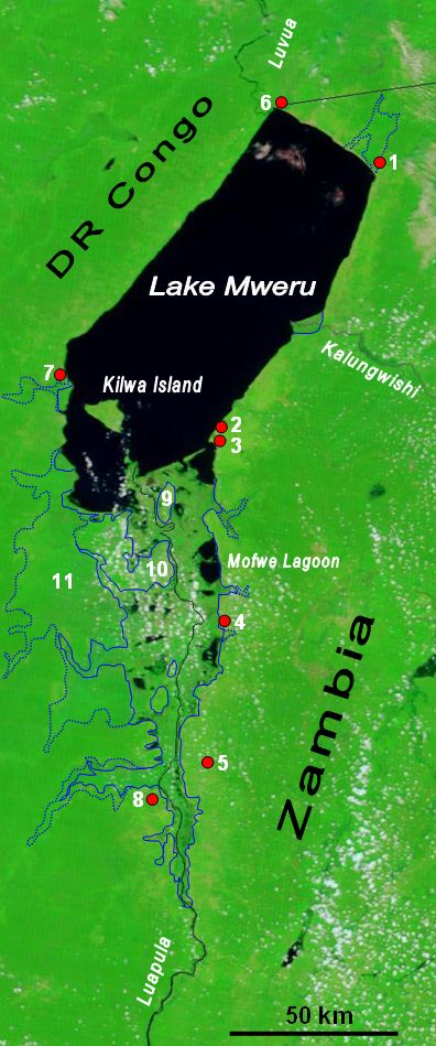
The Kalungwishi River flows west in northern Zambia into Lake Mweru. It is known for its waterfalls, including the Lumangwe Falls, Kabweluma Falls, Kundabwika Falls and Mumbuluma Falls. There are plans to build two hydro power plants on the Kundabwika and kabwelume falls. This has not pleased everyone as some feel the beauty of the water falls will be disturbed. The Kalungwishi pontoon on the Kawambwa-Mporokoso Mporokoso (also spelled and pronounced 'Mpolokoso' and 'Mumpolokoso') is a town in the Northern Province of Zambia, lying at an elevation of nearly 1500 m on the flat plateau about 75 km south east of Lake Mweru Wantipa and 100 km south-west of ... road above Lumangwe Falls was replaced by a new bridge in 2004. Location References Rivers of Zambia Lake Mweru {{Zambia-river-stub ... [...More Info...] [...Related Items...] OR: [Wikipedia] [Google] [Baidu] |
Zambia
Zambia (), officially the Republic of Zambia, is a landlocked country at the crossroads of Central Africa, Central, Southern Africa, Southern and East Africa, although it is typically referred to as being in Southern Africa at its most central point. Its neighbours are the Democratic Republic of the Congo to the north, Tanzania to the northeast, Malawi to the east, Mozambique to the southeast, Zimbabwe and Botswana to the south, Namibia to the southwest, and Angola to the west. The capital city of Zambia is Lusaka, located in the south-central part of Zambia. The nation's population of around 19.5 million is concentrated mainly around Lusaka in the south and the Copperbelt Province to the north, the core economic hubs of the country. Originally inhabited by Khoisan peoples, the region was affected by the Bantu expansion of the thirteenth century. Following the arrival of European exploration of Africa, European explorers in the eighteenth century, the British colonised the r ... [...More Info...] [...Related Items...] OR: [Wikipedia] [Google] [Baidu] |
Lake Mweru
Lake Mweru (also spelled ''Mwelu'', ''Mwero'') is a freshwater lake on the longest arm of Africa's second-longest river, the Congo. Located on the border between Zambia and Democratic Republic of the Congo, it makes up of the total length of the Congo, lying between its Luapula River (upstream) and Luvua River (downstream) segments.Google Earth accessed 29 March 2007. When in flood Lake Bangweulu and its swamps may temporarily have a larger area, but not a larger volume. Mweru means 'lake' in a number of Bantu languages, so it is often referred to as just 'Mweru'.The ''Northern Rhodesia Journal'' online at NZRAM.org: J B W Anderson: "Kilwa Island and the Luapula." Vol II, No. 3 pp87–88 (1954) Physical geography Mweru is mainly fed by the Luapula River, which comes in through swamps from the south, and the Kalungwishi River from the east. At its north end the lake is drained by the Luvua River, which flows in a northwesterly direction to join the Lualaba River and thence to th ... [...More Info...] [...Related Items...] OR: [Wikipedia] [Google] [Baidu] |
Waterfall
A waterfall is a point in a river or stream where water flows over a vertical drop or a series of steep drops. Waterfalls also occur where meltwater drops over the edge of a tabular iceberg or ice shelf. Waterfalls can be formed in several ways, but the most common method of formation is that a river courses over a top layer of resistant bedrock before falling on to softer rock, which Erosion, erodes faster, leading to an increasingly high fall. Waterfalls have been studied for their impact on species living in and around them. Humans have had a distinct relationship with waterfalls for years, travelling to see them, exploring and naming them. They can present formidable barriers to navigation along rivers. Waterfalls are religious sites in many cultures. Since the 18th century they have received increased attention as tourist destinations, sources of hydropower, andparticularly since the mid-20th centuryas subjects of research. Definition and terminology A waterfall is gen ... [...More Info...] [...Related Items...] OR: [Wikipedia] [Google] [Baidu] |
Lumangwe Falls
Lumangwe Falls on the Kalungwishi River in northern Zambia is the largest waterfall wholly within the country, with a height of 30-40 m and a width of 100-160 m. It is a block-type waterfall located between the Luapula and Northern Provinces. The main bedrock is interbedded quartzite with layers of red siltstone. The falls are 80 km from Mporokoso on the Kawambwa road. It has a similar depth of water falling over the edge to the Victoria Falls (Mosi-oa-Tunya) on the Zambezi for which it is frequently mistaken in photographs. Lumangwe Falls forms part of the Lumangwe Falls / Kabwelume Falls / Chimpepe Falls Complex, a national monument in Zambia. At the river's height at the end of the rainy season in April / May, spray from the waterfall may be carried 100 m into the air and the roaring sound in the gorge below seems to shake the ground. Lumangwe Falls are reached via a 10 km earth road which turns west from the Kawambwa-Mporokoso gravel road, 2.5 km north-east of the Kalungwishi ... [...More Info...] [...Related Items...] OR: [Wikipedia] [Google] [Baidu] |
Kabweluma Falls
Kabwelume Falls is a waterfall on the Kalungwishi River in the Northern Province of Zambia. The falls is about 6 km down stream of Lumangwe Falls Lumangwe Falls on the Kalungwishi River in northern Zambia is the largest waterfall wholly within the country, with a height of 30-40 m and a width of 100-160 m. It is a block-type waterfall located between the Luapula and Northern Provinces. The .... When viewed at peak water volume (April/May), a month after the wet season, the falls makes a spectacular semi circle of falling water. There are plans to build a hydro power station on this falls. {{zambia-geo-stub Waterfalls of Zambia Geography of Northern Province, Zambia ... [...More Info...] [...Related Items...] OR: [Wikipedia] [Google] [Baidu] |
Mumbuluma Falls
Mumbuluma Falls is a set of waterfalls just outside Mansa, Zambia in the Luapula Province Luapula Province is one of Zambia's ten provinces located in the northern part of the country. Luapula Province is named after the Luapula River and its capital is Mansa. As per the 2010 Zambian census, the Province had a population of 991,92 .... The waterfalls are a national monument of Zambia. Mumbuluma Falls is made up of two waterfalls occurring in succession, an upper and lower falls. External links Satellite view via Google MapsPhoto gallery of Mumbuluma Falls Waterfalls of Zambia Geography of Luapula Province Tourist attractions in Luapula Province {{Zambia-geo-stub ... [...More Info...] [...Related Items...] OR: [Wikipedia] [Google] [Baidu] |
Hydroelectricity
Hydroelectricity, or hydroelectric power, is Electricity generation, electricity generated from hydropower (water power). Hydropower supplies one sixth of the world's electricity, almost 4500 TWh in 2020, which is more than all other Renewable energy, renewable sources combined and also more than nuclear power. Hydropower can provide large amounts of Low-carbon power, low-carbon electricity on demand, making it a key element for creating secure and clean electricity supply systems. A hydroelectric power station that has a dam and reservoir is a flexible source, since the amount of electricity produced can be increased or decreased in seconds or minutes in response to varying electricity demand. Once a hydroelectric complex is constructed, it produces no direct waste, and almost always emits considerably less greenhouse gas than fossil fuel-powered energy plants. [...More Info...] [...Related Items...] OR: [Wikipedia] [Google] [Baidu] |
Pontoon Bridge
A pontoon bridge (or ponton bridge), also known as a floating bridge, uses float (nautical), floats or shallow-draft (hull), draft boats to support a continuous deck for pedestrian and vehicle travel. The buoyancy of the supports limits the maximum load that they can carry. Most pontoon bridges are temporary and used in wartime and civil emergencies. There are permanent pontoon bridges in civilian use that can carry highway traffic. Permanent floating bridges are useful for sheltered water crossings if it is not considered economically feasible to suspend a bridge from anchored piers. Such bridges can require a section that is elevated or can be raised or removed to allow waterborne traffic to pass. Pontoon bridges have been in use since ancient times and have been used to great advantage in many battles throughout history, such as the Battle of Garigliano (1503), Battle of Garigliano, the Battle of Oudenarde, the Operation Plunder, crossing of the Rhine during World War II, the ... [...More Info...] [...Related Items...] OR: [Wikipedia] [Google] [Baidu] |
Kawambwa
Kawambwa is a town in the Zambian province of Luapula located on thedge of the northern Zambian plateau above the Luapula valley at an altitude of 1300 m. It was chosen as an administrative district of the same name by the British colonial authorities who preferred the climate of the plateau rather than the hotter valley where most of the district's population live, and it continues as an administrative district today. Kawambwa sits at the junction of tarred roads to Nchelenge, Mporokoso, Mushota and Mansa, and Mbereshi linking with the Zambia Way, the main tarred highway of the Luapula Province through Mwansabombwe and Mansa. Zambia's largest tea plantation is situated 27 km from Kawambwa on the Mporokoso road. A camp for refugees of war in the eastern DR Congo was established by United Nations agencies at Kala 24 km north of Kawambwa in 1998, with a capacity for 40,000 refugees. Near to Kawambwa are three of Zambia's waterfalls Lumangwe Falls , Kabwelume 50 ... [...More Info...] [...Related Items...] OR: [Wikipedia] [Google] [Baidu] |
Mporokoso
Mporokoso (also spelled and pronounced 'Mpolokoso' and 'Mumpolokoso') is a town in the Northern Province of Zambia, lying at an elevation of nearly 1500 m on the flat plateau about 75 km south east of Lake Mweru Wantipa and 100 km south-west of Lake Tanganyika. It is named for Chief Mporokoso (also spelled 'Mumpolokoso') a senior chief of the Bemba people whose palace is located at Chishamwamba close to the town. {{webarchive, url=https://web.archive.org/web/20070927224205/http://www.times.co.zm/news/viewnews.cgi?category=4&id=1056658325 , date=2007-09-27 accessed 4 February 2007 Mporokoso District is also one of the 12 of the Northern Province. ... [...More Info...] [...Related Items...] OR: [Wikipedia] [Google] [Baidu] |


.jpg)

