|
Kalarsky District
Kalarsky District (russian: Каларский район) is an administrativeRegistry of the Administrative-Territorial Units and the Inhabited Localities and municipalLaw #316-ZZK district (raion), one of the thirty-one in Zabaykalsky Krai, Russia. It is located in the north of the krai, and borders with Tungokochensky District in the south. The area of the district is . Its administrative center is the rural locality (a '' selo'') of Chara. Population: 9,785 ( 2002 Census); The population of Chara accounts for 21.0% of the district's total population. History The district was established on September 2, 1938. Geography It is the northernmost district of Transbaikalia. The relief is mostly mountainous and includes the Kodar Range, with the highest point of Transbaikalia, Peak BAM, as well as the Udokan Range, Kalar Range and part of the Patom Highlands, among others. There are also vast intermontane basins, and the unique Chara Sands area. On the territory of the r ... [...More Info...] [...Related Items...] OR: [Wikipedia] [Google] [Baidu] |
Zabaykalsky Krai
Zabaykalsky Krai ( rus, Забайкальский край, r=Zabaikal'skii krai, p=zəbɐjˈkalʲskʲɪj kraj, lit. "Transbaikal krai"; bua, Yбэр Байгалай хизаар, Uber Baigalai Xizaar) is a federal subject of Russia (a krai) that was created on March 1, 2008 as a result of a merger of Chita Oblast and Agin-Buryat Autonomous Okrug, after a referendum held on the issue on March 11, 2007. The Krai is now part of the Russian Far East as of November 2018 in accordance with a decree issued by Russian President Vladimir Putin. The administrative center of the krai is located in the city of Chita. As of the 2010 Census, the population was 1,107,107. Geography The krai is located within the historical region of Transbaikalia (Dauria) and has extensive international borders with China (Inner Mongolia and Heilongjiang) (998 km) and Mongolia (Dornod Province, Khentii Province and Selenge Province) (868 km); its internal borders are with Irkutsk and Am ... [...More Info...] [...Related Items...] OR: [Wikipedia] [Google] [Baidu] |
Udokan Range
The Udokan Range (russian: хребет Удокан) is a mountain range in Sakha Republic (Yakutia) and Zabaykalsky Krai, Russian Federation. The nearest town is Chara.Google Earth There is copper mining in the range at the Udokan mine, part of the Udokan Ore Region that includes the Kalar and Kodar ranges.Udokan Ore Region / '':'' in 30 vols. - Ch. ed. A.M. Prokhorov. - 3rd ed. - M. Soviet Encyclopedia, 1969-1978. A stretch of the passes through the range following the valley of the Khani river. ... [...More Info...] [...Related Items...] OR: [Wikipedia] [Google] [Baidu] |
Bolshoye Leprindo
Bolshoye (russian: Большое) is a rural locality (a selo) in Prokhorovsky District, Belgorod Oblast Belgorod Oblast (russian: Белгоро́дская о́бласть, ''Belgorodskaya oblast'') is a federal subject of Russia (an oblast). Its administrative center is the city of Belgorod. Population: History At the turn of the 17th cent ..., Russia. The population was 343 as of 2010. There are 6 streets. Geography Bolshoye is located 25 km southeast of Prokhorovka (the district's administrative centre) by road. Khmelevoye is the nearest rural locality. Bolshoye is 260 meters higher from sea level. References Rural localities in Prokhorovsky District {{BelgorodOblast-geo-stub ... [...More Info...] [...Related Items...] OR: [Wikipedia] [Google] [Baidu] |
Nichatka
Nichatka (russian: Ничатка; evn, нича) is a fresh water body in the Kalarsky District, Zabaykalsky Krai, Russia. The lake has an area of . The name of the lake comes from the Evenki language word for "fish". Nichatka is located to the northeast of the great Lake Baikal, Baikal. There are no settlements on the banks of the lake. The nearest airfield is Chara Airport. Geography Nichatka is a long and narrow lake east of the Canyon, gorges of the Vitim River, off the eastern limit of the Delyun-Uran Range. It stretches roughly from north to south at the southern end of the Patom Highlands and to the north of the Kodar Range. The Sen (Vitim), Sen River, a tributary of the Chara (river), Chara, flows from the northern end of the lakeshore.There are other deep lakes nearby, such as Lake Oron, Oron to the southwest, but Nichatka is the deepest of the lakes of the Chara river basin. The lake is frozen between October and May; in the winter the thickness of the ice my reach . ... [...More Info...] [...Related Items...] OR: [Wikipedia] [Google] [Baidu] |
Konda (Vitim)
The Konda (russian: Конда) is a river in Buryatia, southern East Siberia, Russia. It is long, and has a drainage basin of . There are a few inhabited places close to the banks of the river, including Tselinny, Konda, Telemba and Alekseevka in the Yeravninsky District.Google Earth The Konda is a river rich in fish. Tourists regularly visit the area for fishing and watersports. There is a military training ground of the Russian Armed Forces Eastern Military District to the west of the left bank of the river in the area of Telemba village. Course The Konda is a right tributary of the Vitim. Its sources are in the small Khudan Range, west of Chita. It flows across mountainous terrain between the northern section of the Yablonoi Mountains and the Chersky Range. The river flows first in a northeastern direction and then bends gradually meandering northwards in a floodplain with about 500 lakes. The largest and most picturesque is Telemba. Finally the Konda meets the Vitim ... [...More Info...] [...Related Items...] OR: [Wikipedia] [Google] [Baidu] |
Kalar (river)
The Kalar (russian: Калар), known as the Levoy Chinoy in its upper section, is a river in Zabaykalsky Krai, southern East Siberia, Russia. It is long, and has a drainage basin of . The area through which the river flows is mountainous in most of its length with frequent rapids in the riverbed.Google Earth The waters are rich in fish, including grayling, lenok, taimen and whitefish, among other species. In the International scale of river difficulty the Kalar is a Class III - IV destination for rafting and kayaking. The Kalar has lent its name to a number of other geographic features, including the Kalar Range, the local Kalar District, as well as Sredny Kalar (Middle Kalar) village by its right bank from its mouth. Course The Kalar is a right tributary of the Vitim. Its sources are between the Udokan Range and the Kalar Range subranges of the Stanovoy Highlands. In its upper course it cuts eastwards across the Kalar Range in a wide arc as the Levoy Chinoy. The river ... [...More Info...] [...Related Items...] OR: [Wikipedia] [Google] [Baidu] |
Chara (river)
, image = 2000 Charoite 613.jpg , image_size = , image_caption = View of the river and piece of charoite , pushpin_map = Russia Sakha Republic , pushpin_map_size = , pushpin_map_caption= Location in the Sakha Republic, Russia , source1_location = Bolshoye Leprindo Lake , source1_coordinates = , source1_elevation = , mouth = Olyokma , mouth_coordinates = , mouth_elevation = , progression = Olyokma→ , subdivision_type1 = Country , subdivision_name1 = Yakutia, Russia , length = , discharge1_avg = , basin_size = The Chara (russian: Ча́ра; sah, Чаара, ''Çaara'') is a left tributary of the Olyokma in Eastern Siberia, Russia. It is long, and has a drainage basin of . Together with the Olyokma, river Chara gives its name to the Olyokma-Chara Plateau (Олёкмо-Чарское плоскогорье), located to the east of its east ... [...More Info...] [...Related Items...] OR: [Wikipedia] [Google] [Baidu] |
Vitim (river)
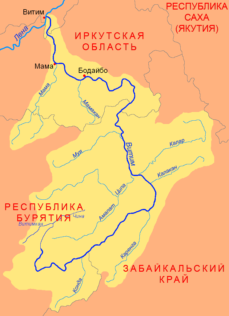
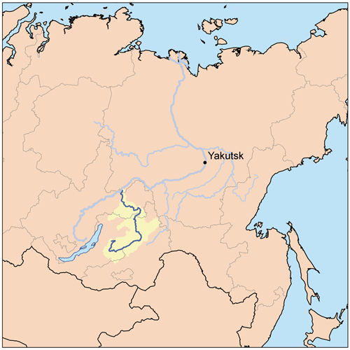
The Vitim (russian: Витим; evn, Витым, ; sah, Виитим, ; Buryat and mn, Витим, ''Vitim'') is a major tributary of the Lena. Its source is east of Lake Baikal, at the confluence of rivers Vitimkan from the west and China from the east. The Vitim flows first south, bends eastwards and then northward in the Vitim Plateau. Then it flows north through the Stanovoy Highlands and the town of Bodaybo. Including river Vitimkan, its western source, it is long, and has a drainage basin of .Витим (река в Бурят. АССР) It is navigable from the Lena to Bodaybo. Upstream, ... [...More Info...] [...Related Items...] OR: [Wikipedia] [Google] [Baidu] |
Chara Sands
The Chara Sands is an area of sand in Siberia near the Kodar and Udokan mountain ranges. It is a small desert wide by long, located in the Charsk basin amid the valleys of Chara, Middle Sakukan and Upper Sakukan rivers. The rapid change from the pine and larch forests and peat bogs to the sand has no transition zone—this is one of the peculiarities of this unusual area, besides the roaming sand dunes A dune is a landform composed of wind- or water-driven sand. It typically takes the form of a mound, ridge, or hill. An area with dunes is called a dune system or a dune complex. A large dune complex is called a dune field, while broad, fl ... and the oases that emerge among them. The Chara Sands is estimated to have formed during the last glacial period 55 to 100 thousand years ago being what is left of an extinct lake formed by runoff from the Sakukan glacier.Chara Sands: Mysterious Siberian Desert, 56thparallel.com Russia travel specialists https://www.56thparallel. ... [...More Info...] [...Related Items...] OR: [Wikipedia] [Google] [Baidu] |
Intermontane Basin
Intermontane is a physiographic adjective formed from the prefix " inter-" (''signifying among, between, amid, during, within, mutual, reciprocal'') and the adjective "montane" (inhabiting, or growing in mountainous regions, especially cool, moist upland slopes below the timberline). The corresponding ''physiographic'' noun is intermountain, while the noun ''intermontane'' is an ''ecologic'' noun meaning ''among, between, amid, or within " flora and fauna of a montane habitat.''" As an example, an alpine region would be an intermontane for a species that migrates between a glacial region and a subalpine region. Use of the term *Intermontane Basin, a wide valley between mountain ranges that is partly filled with alluvium such as New Zealand's Mackenzie Basin. *Intermontane Belt, a physiogeological region in the North American Pacific Northwest. *Intermontane Plateaus, the United States physiographic region of the Intermountain West. *Intermontane Steppe, a term used mainly i ... [...More Info...] [...Related Items...] OR: [Wikipedia] [Google] [Baidu] |
Patom Highlands
The Patom Highlands ( rus, Патомское нагорье) are a mountainous area in Eastern Siberia, Russia. Administratively most of the territory of the uplands is part of Irkutsk Oblast, with a smaller section in northern Transbaikal Krai.Google Earth There are large deposits of gold in Bodaybo and Artyomovsky, Irkutsk Oblast, Artyomovsky. Besides these two towns, other inhabited localities of the mountain region are: Mama, Russia, Mama, Perevoz, Bodaybinsky District, Irkutsk Oblast, Perevoz, Kropotkin, Irkutsk Oblast, Kropotkin, Svetly, Bodaybinsky District, Irkutsk Oblast,, Svetly and Bolshoy Patom (village), Bolshoy Patom, Bodaybinsky District. History In 1912 there was a massacre of striking workers of the Lena Goldfields, located in the Patom Highlands between the Lena and Vitim rivers. Strikers were protesting about harsh working conditions. Soldiers of the Imperial Russian Army intervened and fired upon protesters, causing hundreds of casualties. The incident provoke ... [...More Info...] [...Related Items...] OR: [Wikipedia] [Google] [Baidu] |


