|
Kakavia (border Crossing)
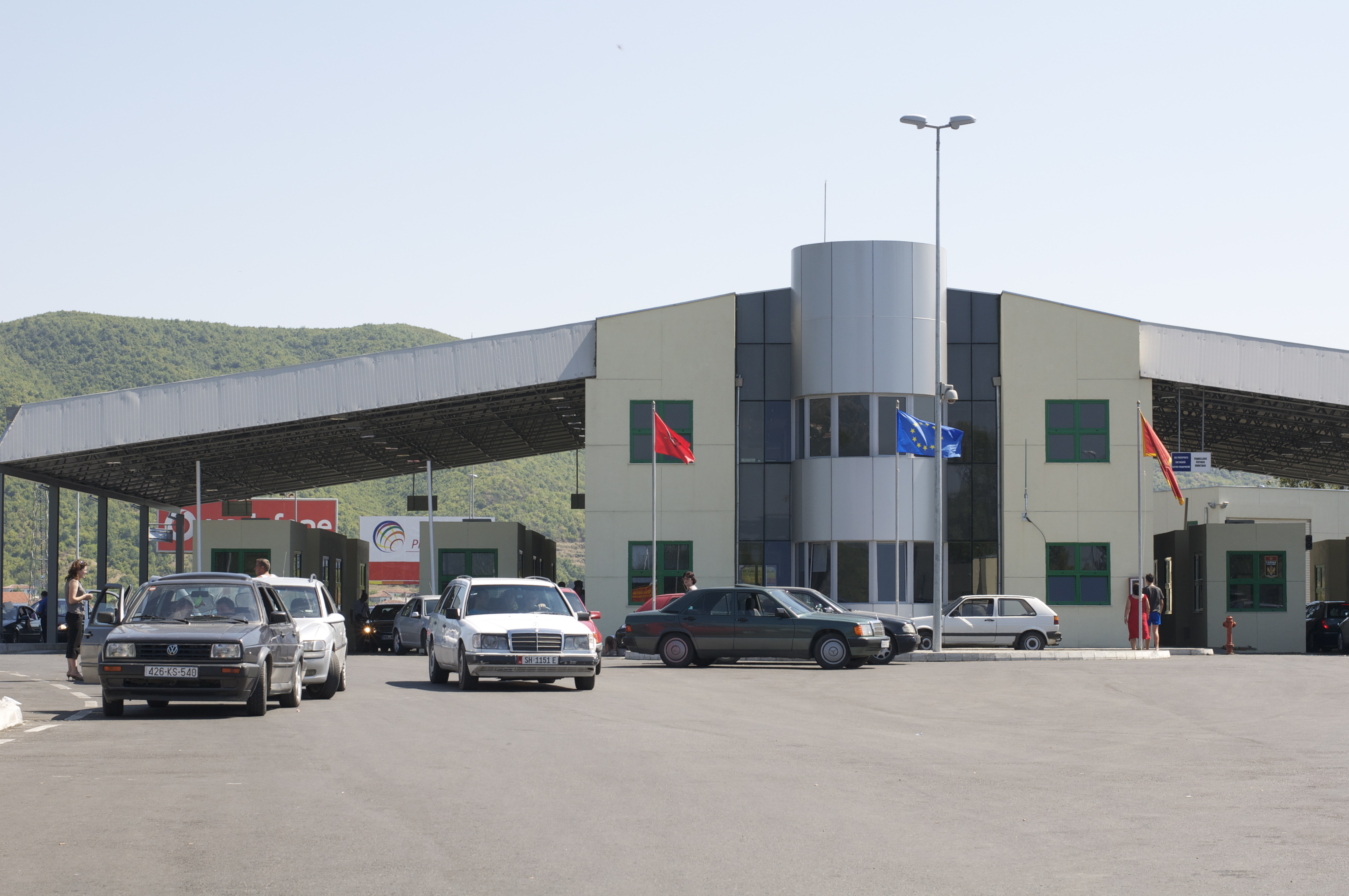
The Kakavia or Kakavijë border crossing ( sq, Pika kufitare e Kakavijës) ( el, Κακαβιά) is a major road border crossing between southern Albania and northwestern Greece. On the Albanian side lies the village of Kakavijë, located in the Gjirokastër County, Dropull region. On the Greek side lies the village of Ktismata, in the Delvinaki municipality, Ioannina regional unit. The main road from Sarandë and Gjirokastër to Ioannina passes through this border crossing. The Greek National Road 22 (GR-22, European route E853) connects Kakavia with the GR-20 at Kalpaki. On August 27, 1923, the Italian general Enrico Tellini, three of his assistants, and their interpreter fell into an ambush and were assassinated by unknown assailants at Kakavia, leading to the Corfu incident The Corfu Incident was a 1923 diplomatic and military crisis between Greece and Italy. It was triggered when an Italian general heading a commission to resolve a border dispute between Albania ... [...More Info...] [...Related Items...] OR: [Wikipedia] [Google] [Baidu] |
Sarandë
Sarandë (; sq-definite, Saranda; el, Άγιοι Σαράντα, Ágioi Saránta) is a city in the Republic of Albania and seat of Sarandë Municipality. Geographically, the city is located on an open sea gulf of the Ionian Sea within the Mediterranean Sea. Stretching along the Albanian Ionian Sea Coast, Saranda has a Mediterranean climate with over 300 sunny days a year. Sarandë is known for its blue deep waters of the Mediterranean. Near Sarandë are the remains of the ancient city of Butrint, a UNESCO World Heritage site. In recent years, Saranda has seen a steady increase in tourists, many of them coming by cruise ship. Visitors are attracted by the natural environment of Saranda and its archaeological sites. Sarandë is inhabited by a majority of ethnic Albanians, and also has a minority Greek community and as such it has been considered one of the two centers of the Greek minority in Albania. [...More Info...] [...Related Items...] OR: [Wikipedia] [Google] [Baidu] |
Enrico Tellini
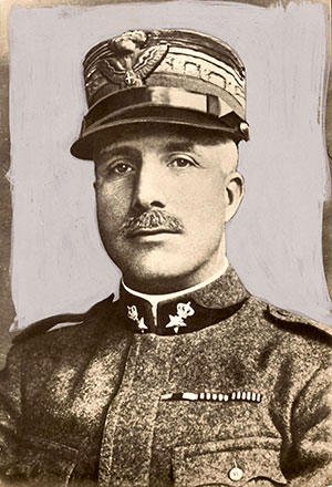
Enrico Tellini (25 August 1871 – 27 August 1923) was an Italian General whose assassination provoked the Corfu incident of 1923. Biography Enrico Tellini was born in Castelnuovo di Garfagnana in the province of Lucca in Tuscany. After a childhood in Florence and enlistment in the Italian army he enrolled in classes at a local military college in Florence. In 1901 he was promoted to the rank of major. He participated in the Italo-Turkish War and during the First World War held various posts until he was badly wounded and captured in the battle of Caporetto. After the end of the hostilities, he commanded Italian troops in Albania. Assassination In 1923, Tellini was part of an Italian delegation sent by the League of Nations to survey the disputed border between Greece and Albania. He was shot and killed, along with four companions, when the car he was driving in was stopped by a fallen tree across the road that ran along the disputed border near the town of Ioannina on the way to ... [...More Info...] [...Related Items...] OR: [Wikipedia] [Google] [Baidu] |
Kalpaki
Kalpaki ( el, Καλπάκι) is a former municipality in the Ioannina regional unit, Epirus, Greece. Since the 2011 local government reform it is part of the municipality Pogoni, of which it is a municipal unit. It is situated about northwest of Ioannina, and southwest of Konitsa. The municipal unit has an area of 116.756 km2, the community 13.189 km2. Population 1,719 (2011). The Greek National Road 20 connects Kalpaki with Ioannina and Konitsa. The GR-22 connects Kalpaki with Kakavia, the border crossing into southern Albania. Subdivisions The municipal unit Kalpaki is subdivided into the following communities (constituent villages in brackets): *Kalpaki (Kalpaki, Lioumpa) *Ano Ravenia *Chrysorrachi *Doliana (Doliana, Agios Georgios Dolianon) *Geroplatanos *Kato Ravenia *Mavrovouni *Negrades Population History Kalpaki joined Greece after the Balkan Wars of 1913. The Battle of Elaia–Kalamas took place in the area in November 1940, during the Italian invasion o ... [...More Info...] [...Related Items...] OR: [Wikipedia] [Google] [Baidu] |
Greek National Road 20
National Road 20 ( el, Εθνική Οδός 20, abbreviated as EO20) is a single carriageway road in northwestern Greece. It links the cities of Ioannina and Kozani via Konitsa and Siatista. It passes through the Ioannina, Kastoria and the Kozani regional units. Since the opening of the A2 (Egnatia Odos), it is no longer the fastest connection between Kozani and Ioannina. The section between Ioannina and Kalpaki is part of the European route E853. Route The western end of National Road 20 is in the centre of Ioannina, where it is connected with the national roads GR-5, GR-6 and GR-17. It runs northwest towards Kalpaki (junction with GR-22), where it turns northeast towards Konitsa. Between Konitsa and Tsotyli it passes through the Pindus mountains. The section between Neapoli and Siatista is shared with the GR-15. From Siatista the GR-20 continues east, until it reaches the city Kozani, its eastern terminus. The National Road 20 passes through the following places (west ... [...More Info...] [...Related Items...] OR: [Wikipedia] [Google] [Baidu] |
European Route E853
European route E 853 is a European B class road in Greece and Albania, connecting the city Ioannina – border Albania. Route * ** E90, E92, E951 Ioannina ** border Albania Albania ( ; sq, Shqipëri or ), or , also or . officially the Republic of Albania ( sq, Republika e Shqipërisë), is a country in Southeastern Europe. It is located on the Adriatic and Ionian Seas within the Mediterranean Sea and shares ... *** SH4 Gjirokastër-Tepelene-Fier-Durrës External links UN Economic Commission for Europe: Overall Map of E-road Network (2007) {{E-road International E-road network Roads in Greece European routes in Albania ... [...More Info...] [...Related Items...] OR: [Wikipedia] [Google] [Baidu] |
Greek National Road 22
Greek National Road 22 is a national highway of Greece. It connects Kakavia, on the border with Albania, with Kalpaki Kalpaki ( el, Καλπάκι) is a former municipality in the Ioannina regional unit, Epirus, Greece. Since the 2011 local government reform it is part of the municipality Pogoni, of which it is a municipal unit. It is situated about northwest o .... It's a part of European route E853. {{coord, 39.9032, 20.5141, display=title 22 Roads in Epirus (region) ... [...More Info...] [...Related Items...] OR: [Wikipedia] [Google] [Baidu] |
Ioannina
Ioannina ( el, Ιωάννινα ' ), often called Yannena ( ' ) within Greece, is the capital and largest city of the Ioannina regional unit and of Epirus, an administrative region in north-western Greece. According to the 2011 census, the city population was 65,574, while the municipality had 112,486 inhabitants.GOV. results of permanent population 2011, p. 10571 (p. 97 of pdf), and in Excel formatTable of permanent population 2011 from the sitHellenic Statistical Authority 24 November 2017. Retrieved 2018-01-09. It lies at an elevation of approximately above sea level, on the western shore of |
Gjirokastër
Gjirokastër (, sq-definite, Gjirokastra) is a city in the Republic of Albania and the seat of Gjirokastër County and Gjirokastër Municipality. It is located in a valley between the Gjerë mountains and the Drino, at 300 metres above sea level. Its old town is a UNESCO World Heritage Site, described as "a rare example of a well-preserved Ottoman town, built by farmers of large estate". The city is overlooked by Gjirokastër Fortress, where the Gjirokastër National Folklore Festival is held every five years. It is the birthplace of former Albanian communist leader Enver Hoxha, and author Ismail Kadare. The city appears in the historical record dating back in 1336 by its Greek name, gkm, Αργυρόκαστρο, Argyrókastro, label=none, as part of the Byzantine Empire. It became part of the Orthodox Christian diocese of ''Dryinoupolis and Argyrokastro'' after the destruction of nearby Adrianoupolis.Giakoumis, Konstantinos (2010).The Orthodox Church in Albania Under ... [...More Info...] [...Related Items...] OR: [Wikipedia] [Google] [Baidu] |
Ioannina (regional Unit)
Ioannina ( el, Περιφερειακή ενότητα Ιωαννίνων) is one of the regional units of Greece. It is part of the region of Epirus. Its capital is the city of Ioannina. It is the largest regional unit in Epirus, and one of the largest regional units of Greece, with a population of 167,901 people, according to the 2011 census.GOV. results of permanent population 2011, p. 10561 (p. 87 of pdf), and in Excel formatTable of permanent population 2011 from the sitHellenic Statistical Authority 2017-11-24. Retrieved 2018-01-09. Geography Ioannina borders in the north, and the regional units of |
Border Crossings Of Albania
Border crossings ( sq, Vendkalimet kufitare) in the Republic of Albania are defined as boundary checkpoints that serve to control the flow of people and goods from neighbouring countries to and from Albania. These checkpoints are administered by the border police authorities that record the entry and exit of each person and vehicle followed by the customs authorities that record the entry and exit of goods and cash. Albania currently has 22 operational land border crossings and shares borders with Montenegro, Kosovo (116.3 km), North Macedonia (186.1 km), and Greece. This article outlines a complete list of Albania's international border crossings, including land, sea and air entry points. History During the communist period in Albania, very few people were allowed to leave the country (usually only diplomats) and would also be required to have written permission to do so. Visitors entering the country from outside for any reason, tourism or otherwise, were immediately suspect an ... [...More Info...] [...Related Items...] OR: [Wikipedia] [Google] [Baidu] |
Delvinaki
Delvinaki ( el, Δελβινάκι) is a former municipality in the Ioannina regional unit, Epirus, Greece. Since the 2011 local government reform it is part of the municipality Pogoni, of which it is a municipal unit. The municipal unit has an area of 255.8 km2, the community 54.8 km2. In 2011 its population was 772 for the village and 2,540 for the municipal unit. Delvinaki is part of the traditional area of Pogoni. Delvinaki lies along the road GR-22/ E853 which links Kalpaki with the Albanian border. The border crossing Kakavia is west of town. Subdivisions The municipal unit of Delvinaki is subdivided into the following communities (constituent villages in brackets): * Agia Marina * Argyrochori * Charavgi *Delvinaki *Farangi (formerly Gouveri) * Kastani * Kerasovo * Kryoneri * Ktismata (Ktismata, Neochori) * Limni * Mavropoulo (Mavropoulo, Zavrocho, Chrysodouli) * Oreino Xirovaltou (Oreino, Xirovaltos) *Peristeri * Pontikates * Stratinista * Teriachi (Teriachi, ... [...More Info...] [...Related Items...] OR: [Wikipedia] [Google] [Baidu] |
.jpg)
.jpg)


