|
Kadleroshilik Pingo
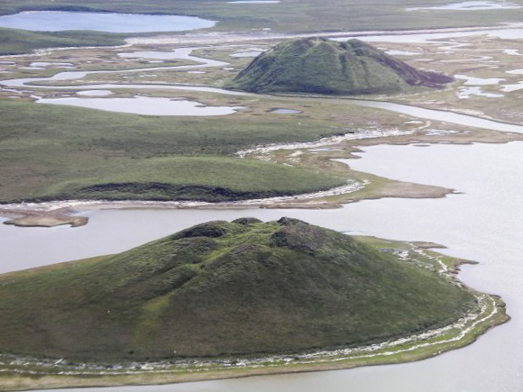
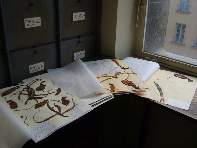
Kadleroshilik Pingo (or Kadleroshilik Mound) is a pingo located about southeast of Prudhoe Bay in the U.S. state of Alaska. Rising to an elevation of above the surrounding lake plain, it is the highest known pingo in the world. The pingo's existence was first noted in the 1919 monograph ''The Canning River Region, Northern Alaska'' by Ernest de Koven Leffingwell. Leffingwell, who had visited the site in 1911, adopted the Eskimo name for the mound, which he interpreted as possibly meaning "possesses something on top" or "which seems to approach"; he also named the nearby Kadleroshilik River for the mound. For her dissertation on the ecology of Alaskan pingos, based on studies conducted in the 1980s, Marilyn Drew Walker selected Kadleroshilik Pingo as one of her study sites specifically because of its unusual size. Botanical specimens she collected at the site are in the herbarium of the University of Alaska Museum of the North The University of Alaska Museum of the North is a c ... [...More Info...] [...Related Items...] OR: [Wikipedia] [Google] [Baidu] |
Pingo
Pingos are intrapermafrost ice-cored hills, high and in diameter. They are typically conical in shape and grow and persist only in permafrost environments, such as the Arctic and subarctic. A pingo is a periglacial landform, which is defined as a non-glacial landform or process linked to colder climates. It is estimated that there are more than 11,000 pingos on Earth. The Tuktoyaktuk peninsula area has the greatest concentration of pingos in the world with a total of 1,350 pingos. There is currently remarkably limited data on pingos. History In 1825, John Franklin made the earliest description of a pingo when he climbed a small pingo on Ellice Island in the Mackenzie Delta. However, it was in 1938 that the term ''pingo'' was first borrowed from the Inuvialuit by the Arctic botanist Alf Erling Porsild in his paper on Earth mounds of the western Arctic coast of Canada and Alaska. Porsild Pingo in Tuktoyaktuk is named in his honour. The term pingos, which in Inuvialuktun m ... [...More Info...] [...Related Items...] OR: [Wikipedia] [Google] [Baidu] |
Prudhoe Bay, Alaska
Prudhoe Bay is a census-designated place (CDP) located in North Slope Borough in the U.S. state of Alaska. As of the 2010 census, the population of the CDP was 2,174 people, up from just five residents in the 2000 census; however, at any given time, several thousand transient workers support the Prudhoe Bay oil field. The airport, lodging and general store are located in Deadhorse, and the rigs and processing facilities are located on scattered gravel pads laid atop the tundra. It is only during winter that the surface is hard enough to support heavy equipment, and new construction happens at that time. Prudhoe Bay is the unofficial northern terminus of the Pan-American Highway. As the bay itself is still 10 miles further north through a security checkpoint, open water is not visible from the highway. A few tourists, arriving by bus after a two-day ride up the Dalton Highway from Fairbanks, come to see the tundra, the Arctic Ocean and the midnight sun, staying in lodgings ass ... [...More Info...] [...Related Items...] OR: [Wikipedia] [Google] [Baidu] |
Alaska
Alaska ( ; russian: Аляска, Alyaska; ale, Alax̂sxax̂; ; ems, Alas'kaaq; Yup'ik: ''Alaskaq''; tli, Anáaski) is a state located in the Western United States on the northwest extremity of North America. A semi-exclave of the U.S., it borders the Canadian province of British Columbia and the Yukon territory to the east; it also shares a maritime border with the Russian Federation's Chukotka Autonomous Okrug to the west, just across the Bering Strait. To the north are the Chukchi and Beaufort Seas of the Arctic Ocean, while the Pacific Ocean lies to the south and southwest. Alaska is by far the largest U.S. state by area, comprising more total area than the next three largest states (Texas, California, and Montana) combined. It represents the seventh-largest subnational division in the world. It is the third-least populous and the most sparsely populated state, but by far the continent's most populous territory located mostly north of the 60th parallel, with ... [...More Info...] [...Related Items...] OR: [Wikipedia] [Google] [Baidu] |
Ernest De Koven Leffingwell
Ernest de Koven Leffingwell (January 13, 1875January 27, 1971) was an arctic explorer, geologist and Spanish–American War veteran. During the period from 1906 to 1914, Leffingwell spent nine summers and six winters on the Arctic coast of Alaska, making 31 trips by dog sled or small boats. He created the first accurate map of a large part of the Alaskan arctic coastline. He was the first to scientifically describe permafrost and to pose theories about permafrost which have largely proven true. He accurately identified the oil potential of the North Slope region of Alaska. Biography Ernest de Koven Leffingwell was born January 13, 1875, in Knoxville, Illinois, to Charles and Elizabeth (née Francis) Leffingwell. He attended the grammar school at Racine College, then attended Trinity College, Hartford, Connecticut, where he was captain of the track team his senior year, graduated with the AB degree in 1895 and was awarded a MA in 1900. He studied physics and geology at the Univ ... [...More Info...] [...Related Items...] OR: [Wikipedia] [Google] [Baidu] |
Iñupiaq Language
Iñupiaq Iñupiaq : , Inupiaq, Iñupiat , Inupiat, Iñupiatun or Alaskan Inuit is an Inuit language, or perhaps languages, spoken by the Iñupiat people in northern and northwestern Alaska, as well as a small adjacent part of the Northwest Territories of Canada. The Iñupiat language is a member of the Inuit-Yupik-Unangan language family, and is closely related to, but not mutually intelligible with, other Inuit languages of Canada and Greenland. There are roughly 2,000 speakers. Iñupiaq is considered to be a threatened language, with most speakers at or above the age of 40. Iñupiaq is an official language of the State of Alaska, along with several other indigenous languages. The major varieties of the Iñupiaq language are the North Slope Iñupiaq and Seward Peninsula Iñupiaq dialects. The Iñupiaq language has been in decline since contact with English in the late 19th century. American territorial acquisition and the legacy of boarding schools have created a situation ... [...More Info...] [...Related Items...] OR: [Wikipedia] [Google] [Baidu] |
Kadleroshilik River
The Kadleroshilik River is a stream in the North Slope Borough of the U.S. state of Alaska. Flowing south to north, it empties into Foggy Island Bay in the Beaufort Sea, about east of Prudhoe Bay. It was named by Ernest de Koven Leffingwell for the nearby Kadleroshilik Pingo, the highest known pingo in the world, which Leffingwell also named. A fish study conducted by the Alaska Department of Fish and Game in 1995 reported Arctic grayling (''Thymallus arcticus''), Dolly Varden trout (''Salvelinus malma''), and ninespine stickleback (''Pungitius pungitius'') in the river. An earlier study had also reported the presence of slimy sculpin The slimy sculpin (''Cottus cognatus'') is a freshwater species of fish belonging to the family Cottidae, which is the largest sculpin family. They usually inhabit cold rocky streams or lakes across North America, ranging from the Great Lakes, so ... (''Cottus cognatus'').Hemming, p. 3. References Rivers of North Slope Borough, Alaska Ri ... [...More Info...] [...Related Items...] OR: [Wikipedia] [Google] [Baidu] |
Herbarium
A herbarium (plural: herbaria) is a collection of preserved plant specimens and associated data used for scientific study. The specimens may be whole plants or plant parts; these will usually be in dried form mounted on a sheet of paper (called ''exsiccatum'', plur. ''exsiccata'') but, depending upon the material, may also be stored in boxes or kept in alcohol or other preservative. The specimens in a herbarium are often used as reference material in describing plant taxa; some specimens may be types. The same term is often used in mycology to describe an equivalent collection of preserved fungi, otherwise known as a fungarium. A xylarium is a herbarium specialising in specimens of wood. The term hortorium (as in the Liberty Hyde Bailey Hortorium) has occasionally been applied to a herbarium specialising in preserving material of horticultural origin. History The making of herbaria is an ancient phenomenon, at least six centuries old, although the techniques have changed l ... [...More Info...] [...Related Items...] OR: [Wikipedia] [Google] [Baidu] |
University Of Alaska Museum Of The North
The University of Alaska Museum of the North is a cultural and historical museum on the University of Alaska Fairbanks campus. Mission The museum's mission is to acquire, conserve, investigate, and interpret specimens and collections relating to the natural, artistic, and cultural heritage of Alaska and the Circumpolar North. Through education, research, and public exhibits, the museum serves the state, national, and international science programs. The museum develops and uses botanical, geological, zoological, and cultural collections; these collections form the basis for understanding past and present issues unique to the North and meeting the challenges of the future. Founding and history The museum, formerly known as the University of Alaska Museum, was housed in what is now known as Signers' Hall for much of its history. It was mandated as part of the original legislation establishing the university in 1917. In 1924, Charles E. Bunnell, then-president of the university, di ... [...More Info...] [...Related Items...] OR: [Wikipedia] [Google] [Baidu] |
Landforms Of North Slope Borough, Alaska
A landform is a natural or anthropogenic land feature on the solid surface of the Earth or other planetary body. Landforms together make up a given terrain, and their arrangement in the landscape is known as topography. Landforms include hills, mountains, canyons, and valleys, as well as shoreline features such as bays, peninsulas, and seas, including submerged features such as mid-ocean ridges, volcanoes, and the great ocean basins. Physical characteristics Landforms are categorized by characteristic physical attributes such as elevation, slope, orientation, stratification, rock exposure and soil type. Gross physical features or landforms include intuitive elements such as berms, mounds, hills, ridges, cliffs, valleys, rivers, peninsulas, volcanoes, and numerous other structural and size-scaled (e.g. ponds vs. lakes, hills vs. mountains) elements including various kinds of inland and oceanic waterbodies and sub-surface features. Mountains, hills, plateaux, and plains are the fou ... [...More Info...] [...Related Items...] OR: [Wikipedia] [Google] [Baidu] |


.jpg)