|
Jurm District
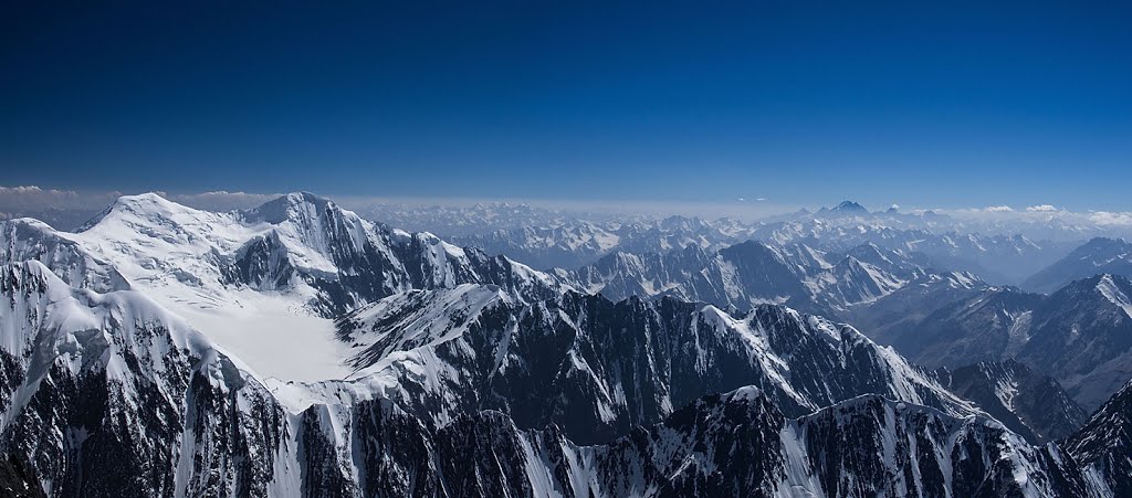
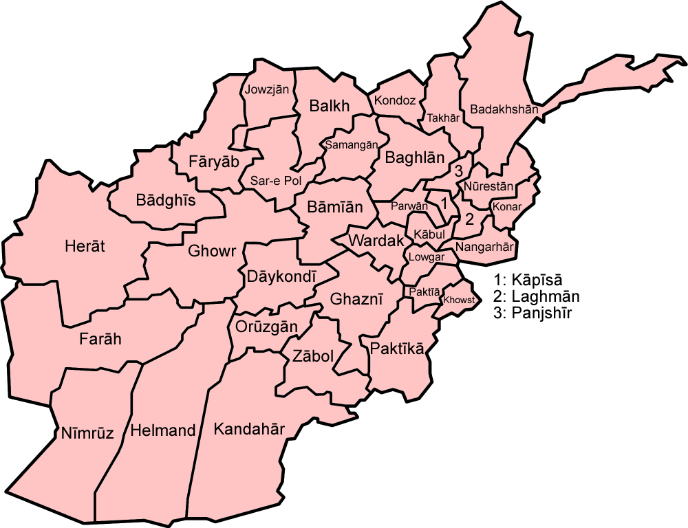
Jurm District (Persian: جورم ولسوالۍ) is one of the 28 districts of Badakhshan Province in northeast Afghanistan. The district capital is a town named Jurm. The district is 3 hours from the center of the province in Fayzabad, and is home to approximately 41,910 residents. The highest point of the Afghan Hindu Kush The Hindu Kush is an mountain range in Central and South Asia to the west of the Himalayas. It stretches from central and western Afghanistan, Quote: "The Hindu Kush mountains run along the Afghan border with the North-West Frontier Provinc ... is located in Jurm District, at 6729 meters. The district consist of clusters and villages. Ferghamenj, Kyb, Kyteb, Ularyb, Ferghameru, Khustak, and Iskan are the clusters. Each cluster contain villages; the district is largely Tajik speaking. References External linksMapat the Afghanistan Information Management Services Districts of Badakhshan Province {{Badakhshan-geo-stub ... [...More Info...] [...Related Items...] OR: [Wikipedia] [Google] [Baidu] |
Districts Of Afghanistan
The districts of Afghanistan, known as ''wuleswali'' ( ps, ولسوالۍ, ''wuləswāləi''; fa, شهرستان, ''shahrestān'') are secondary-level administrative units, one level below provinces. The Afghan government issued its first district map in 1973.''Afghanistan; Districts and Codes by Province'', Edition 2.0, AID / Rep. DC&A Mapping Unit, October 1991, Peshawar, Pakista/ref> It recognized 325 districts, counting ''wuleswalis'' (districts), ''alaqadaries'' (sub-districts), and ''markaz-e-wulaiyat'' (provincial center districts). In the ensuing years, additional districts have been added through splits, and some eliminated through merges. In June 2005, the Afghan government issued a map of 398 districts. It was widely adopted by many information management systems, though usually with the addition of ''Sharak-e-Hayratan'' for 399 districts in total. It remains the ''de facto'' standard as of late 2018, despite a string of government announcements of the creation of ... [...More Info...] [...Related Items...] OR: [Wikipedia] [Google] [Baidu] |
Badakhshan Province
Badakhshan Province (Persian/ Uzbek: , ''Badaxšān'') is one of the 34 provinces of Afghanistan, located in the northeastern part of the country. It is bordered by Tajikistan's Gorno-Badakhshan in the north and the Pakistani regions of Lower and Upper Chitral and Gilgit-Baltistan in the southeast. It also has a 91-kilometer (57-mile) border with China in the east. It is part of a broader historical Badakhshan region, parts of which now also lie in Tajikistan and China. The province contains 22 districts, over 1,200 villages and approximately 1 055 00people. Fayzabad, Badakhshan, Fayzabad serves as the provincial capital. Resistance activity has been reported in the province since the 2021 Taliban takeover of Afghanistan. Etymology Badakhshan's name comes from the Middle Persian word "badaxš", which is an official title. The word "ān" is a suffix which demonstrates a place's name; therefore the word "badaxšān" means a place belonging to a person called "badaxš". Duri ... [...More Info...] [...Related Items...] OR: [Wikipedia] [Google] [Baidu] |
Districts Of Afghanistan
The districts of Afghanistan, known as ''wuleswali'' ( ps, ولسوالۍ, ''wuləswāləi''; fa, شهرستان, ''shahrestān'') are secondary-level administrative units, one level below provinces. The Afghan government issued its first district map in 1973.''Afghanistan; Districts and Codes by Province'', Edition 2.0, AID / Rep. DC&A Mapping Unit, October 1991, Peshawar, Pakista/ref> It recognized 325 districts, counting ''wuleswalis'' (districts), ''alaqadaries'' (sub-districts), and ''markaz-e-wulaiyat'' (provincial center districts). In the ensuing years, additional districts have been added through splits, and some eliminated through merges. In June 2005, the Afghan government issued a map of 398 districts. It was widely adopted by many information management systems, though usually with the addition of ''Sharak-e-Hayratan'' for 399 districts in total. It remains the ''de facto'' standard as of late 2018, despite a string of government announcements of the creation of ... [...More Info...] [...Related Items...] OR: [Wikipedia] [Google] [Baidu] |
Afghanistan
Afghanistan, officially the Islamic Emirate of Afghanistan,; prs, امارت اسلامی افغانستان is a landlocked country located at the crossroads of Central Asia and South Asia. Referred to as the Heart of Asia, it is bordered by Pakistan to the Durand Line, east and south, Iran to the Afghanistan–Iran border, west, Turkmenistan to the Afghanistan–Turkmenistan border, northwest, Uzbekistan to the Afghanistan–Uzbekistan border, north, Tajikistan to the Afghanistan–Tajikistan border, northeast, and China to the Afghanistan–China border, northeast and east. Occupying of land, the country is predominantly mountainous with plains Afghan Turkestan, in the north and Sistan Basin, the southwest, which are separated by the Hindu Kush mountain range. , Demographics of Afghanistan, its population is 40.2 million (officially estimated to be 32.9 million), composed mostly of ethnic Pashtuns, Tajiks, Hazaras, and Uzbeks. Kabul is the country's largest city and ser ... [...More Info...] [...Related Items...] OR: [Wikipedia] [Google] [Baidu] |
Jurm City
Jorm (also spelled Jurm; ) is a village in Badakhshan Province in north-eastern Afghanistan. The village is located on the left bank of the Kokcha River, about 7 miles upstream the junction with the Warduj River. Around the turn of the 20th century, it was described as being a large collection of scattered hamlets, with a population of at least 400 families, possibly much more. The name Jorm is said to be derived from the fine Timur Lang placed on the villagers for an attack on his troops. The village proper lies on the left bank of the river, but its associated hamlets run 3 miles up and downstream from there on both banks. There was a large, ruined fort about one-half mile south of the village proper where the hakim of Jurm resided. He commanded the Yamgan-Warduj and Barak subdistricts. Huts for those who graze their livestock can be found on both sides of the river up and down stream of Jurm. The location is highly regarded for its fruit and other vegetation, as well as for it ... [...More Info...] [...Related Items...] OR: [Wikipedia] [Google] [Baidu] |
Fayzabad, Badakhshan
Fayzabad (also spelled Feyzabad or Faizabad) ( fa, فيض آباد, Fayzâbâd) is a city in northeastern Afghanistan, with a population of around 39,555 people. It serves as the provincial capital and largest city of Badakhshan Province. It is situated in Fayzabad District and is at an altitude of . Fayzabad is the main commercial and administrative center of the Pamir region. The Kokcha River runs alongside the city. The Fayzabad Airport is located next to the city, which provides limited domestic flight services. History The city was called Jauz Gun until 1680 because of the many walnut ("jauz") farms in the area. The name was changed to Faizabad, which can be roughly translated as "abode of divine bounty, blessing, and charity", when the robe of Prophet Muhammed was delivered to the city. Tradition states that it was brought here by Muhammad Shaykh Ziya and Shaykh Niyaz after Wais Quran brought it to Balkh. At that time the city replaced Munjan as the capital of Badakhsha ... [...More Info...] [...Related Items...] OR: [Wikipedia] [Google] [Baidu] |
Central Statistics Organization (Afghanistan)
The National Statistics and Information Authority (NSIA, fa, اداره ملی احصائیه و معلومات, ps, د احصایې او معلوماتو ملي اداره), formerly the Central Statistics Organization (CSO; fa, ادارۀ مرکزی احصائیه ; ps, داحصاي مرکزی اداره), is the Afghan government agency charged with collecting and maintaining statistical data for Afghanistan. The head office was in District 7 of Kabul. It was first established in 1972. References External links NSIA website Government of Afghanistan Afghanistan Afghanistan, officially the Islamic Emirate of Afghanistan,; prs, امارت اسلامی افغانستان is a landlocked country located at the crossroads of Central Asia and South Asia. Referred to as the Heart of Asia, it is bordere ... 1972 establishments in Afghanistan Government agencies in Afghanistan {{Afghanistan-gov-stub ... [...More Info...] [...Related Items...] OR: [Wikipedia] [Google] [Baidu] |
Hindu Kush
The Hindu Kush is an mountain range in Central and South Asia to the west of the Himalayas. It stretches from central and western Afghanistan, Quote: "The Hindu Kush mountains run along the Afghan border with the North-West Frontier Province of Pakistan". into northwestern Pakistan and far southeastern Tajikistan. The range forms the western section of the ''Hindu Kush Himalayan Region'' (''HKH''); to the north, near its northeastern end, the Hindu Kush buttresses the Pamir Mountains near the point where the borders of China, Pakistan and Afghanistan meet, after which it runs southwest through Pakistan and into Afghanistan near their border. The eastern end of the Hindu Kush in the north merges with the Karakoram Range.Karakoram Range: MOUNTAINS, ASIA Encyclopædia Britannica Towards its s ... [...More Info...] [...Related Items...] OR: [Wikipedia] [Google] [Baidu] |


