|
Jailolo (town)
Jailolo is a town and former sultanate on Halmahera in Indonesia's Maluku Islands. It is located on the island's west coast approximately 20 km north of Ternate. Jailolo is a small port that serves Halmahera's northwestern coastal villages. Before the arrival of Europeans it was the most important political power on Halmahera. It is thought that the sultanate had a measure of influence and autonomy as a combined Portuguese and Ternatean force overran in it 1551. It was then under the control of the Dutch and Ternateans for two centuries. The Sultanate was re-established in 1798, by the Sultan of Tidore who had expelled the Dutch from his island and proclaimed a noble from Makian as Sultan of Jailolo. The Dutch forced the aristocracy into exile in 1832. Baba Hassan attempted a revolt in 1876, but his rebellion was easily put down by steam-powered Dutch warships. In 1914, a revolt over taxation saw Jailoloans kill the colonial district officer, and there was a revolt on the is ... [...More Info...] [...Related Items...] OR: [Wikipedia] [Google] [Baidu] |
Sultanate Of Jailolo
The Sultanate of Jailolo (كسلطانن جايلولو) was a premodern state in Maluku, modern Indonesia that emerged with the increasing trade in cloves in the Middle Ages. Also spelt Gilolo, it was one of the four kingdoms of Maluku together with Ternate, Tidore, and Bacan, having its center at a bay on the west side of Halmahera. Jailolo existed as an independent kingdom until 1551 and had separate rulers for periods after that date. A revivalist Raja Jailolo movement made for much social and political unrest in Maluku in the 19th century. In modern times the sultanate has been revived as a symbolic entity. Origins Jailolo was a component in the politico-ritual quadripartition of northern Maluku, ''Maloko Kië Raha'' or the Four Mountains of Maluku. Its king was known as Jika ma-kolano, Ruler of the Bay, highlighting the Jailolo Bay as the major port in Halmahera. It is locally believed that the kingdom encompassed the entire island or at least the major part. However, in hi ... [...More Info...] [...Related Items...] OR: [Wikipedia] [Google] [Baidu] |
Halmahera
Halmahera, formerly known as Jilolo, Gilolo, or Jailolo, is the largest island in the Maluku Islands. It is part of the North Maluku province of Indonesia, and Sofifi, the capital of the province, is located on the west coast of the island. Halmahera has a land area of ; it is the largest island of Indonesia outside the five main islands. It had a population of 162,728 in 1995; by 2010, it had increased to 449,938 for the island itself (excluding the tip which is considered part of the Joronga Islands, but including Gebe and Ju islands) and 667,161 for the island group (including all of South Halmahera and Tidore, but not Ternate). Approximately half of the island's inhabitants are Muslim and half are Christian. History Sparsely-populated Halmahera's fortunes have long been closely tied to those of the smaller islands of Ternate and Tidore, both off its west coast. These islands were both the sites of major kingdoms in the era before Dutch East India Company colonized the e ... [...More Info...] [...Related Items...] OR: [Wikipedia] [Google] [Baidu] |
Indonesia
Indonesia, officially the Republic of Indonesia, is a country in Southeast Asia and Oceania between the Indian and Pacific oceans. It consists of over 17,000 islands, including Sumatra, Java, Sulawesi, and parts of Borneo and New Guinea. Indonesia is the world's largest archipelagic state and the 14th-largest country by area, at . With over 275 million people, Indonesia is the world's fourth-most populous country and the most populous Muslim-majority country. Java, the world's most populous island, is home to more than half of the country's population. Indonesia is a presidential republic with an elected legislature. It has 38 provinces, of which nine have special status. The country's capital, Jakarta, is the world's second-most populous urban area. Indonesia shares land borders with Papua New Guinea, East Timor, and the eastern part of Malaysia, as well as maritime borders with Singapore, Vietnam, Thailand, the Philippines, Australia, Palau, and India ... [...More Info...] [...Related Items...] OR: [Wikipedia] [Google] [Baidu] |
Maluku Islands
The Maluku Islands (; Indonesian: ''Kepulauan Maluku'') or the Moluccas () are an archipelago in the east of Indonesia. Tectonically they are located on the Halmahera Plate within the Molucca Sea Collision Zone. Geographically they are located east of Sulawesi, west of New Guinea, and north and east of Timor. Lying within Wallacea (mostly east of the biogeographical Weber Line), the Maluku Islands have been considered as a geographical and cultural intersection of Asia and Oceania. The islands were known as the Spice Islands because of the nutmeg, mace and cloves that were exclusively found there, the presence of which sparked colonial interest from Europe in the sixteenth century. The Maluku Islands formed a single province from Indonesian independence until 1999, when it was split into two provinces. A new province, North Maluku, incorporates the area between Morotai and Sula, with the arc of islands from Buru and Seram to Wetar remaining within the existing Maluku Province. ... [...More Info...] [...Related Items...] OR: [Wikipedia] [Google] [Baidu] |
Ternate
Ternate is a city in the Indonesian province of North Maluku and an island in the Maluku Islands. It was the ''de facto'' provincial capital of North Maluku before Sofifi on the nearby coast of Halmahera became the capital in 2010. It is off the west coast of Halmahera, and is composed of eight islands: Ternate, the biggest and main island of the city, and Moti, Hiri, Tifure, Mayau, Makka, Mano, and Gurida. In total, the city has a land area of 162.17 square kilometres and had a total population of 185,705 according to the 2010 census, and 205,001 according to the 2020 census, with a density of 1,264 people per square kilometre. It is the biggest and most densely populated city in the province, is the economic, cultural, and education center of North Maluku, and acts as a hub to neighbouring regions. It was the capital of the Sultanate of Ternate in the 15th and 16th centuries, and fought against the Sultanate of Tidore over control of the spice trade in the Moluccas before becomin ... [...More Info...] [...Related Items...] OR: [Wikipedia] [Google] [Baidu] |
Portugal
Portugal, officially the Portuguese Republic ( pt, República Portuguesa, links=yes ), is a country whose mainland is located on the Iberian Peninsula of Southwestern Europe, and whose territory also includes the Atlantic archipelagos of the Azores and Madeira. It features the westernmost point in continental Europe, and its Iberian portion is bordered to the west and south by the Atlantic Ocean and to the north and east by Spain, the sole country to have a land border with Portugal. Its two archipelagos form two autonomous regions with their own regional governments. Lisbon is the capital and largest city by population. Portugal is the oldest continuously existing nation state on the Iberian Peninsula and one of the oldest in Europe, its territory having been continuously settled, invaded and fought over since prehistoric times. It was inhabited by pre-Celtic and Celtic peoples who had contact with Phoenicians and Ancient Greek traders, it was ruled by the Ro ... [...More Info...] [...Related Items...] OR: [Wikipedia] [Google] [Baidu] |
Makian
Makian (also Machian), known to local people as Mount Kie Besi, is a volcanic island, one of the Maluku Islands within the province of North Maluku in Indonesia. It lies near the southern end of a chain of volcanic islands off the western coast of the province's major island, Halmahera, and lies between the islands of Moti and Tidore to the north and Kayoa and the Bacan Group to the south. The island, which forms two districts (''Pulau Makian'' and ''Makian Barat'') within South Halmahera Regency of North Maluku Province, covers an area of 84.36 sq.km, and had a population of 12,394 at the 2010 Census, which rose to 14,000 at the 2020 Census. The island is wide, and its high summit consists of a large wide crater, with a small lake on its Northeast side. There are four parasitic cones on the western slopes of Makian. Makian volcano is also known as Mount Kiebesi (or Kie Besi). Volcanic history Makian volcano has had infrequent, but violent eruptions that destroyed villages o ... [...More Info...] [...Related Items...] OR: [Wikipedia] [Google] [Baidu] |
Waigeo
Waigeo is an island in Southwest Papua province of eastern Indonesia. The island is also known as Amberi, or Waigiu. It is the largest of the four main islands in the Raja Ampat Islands Raja Ampat, or the ''Four Kings'', is an archipelago located off the northwest tip of Bird's Head Peninsula on the island of New Guinea, in Indonesia's Southwest Papua province. It comprises over 1,500 small islands, cays, and shoals surrounding ... archipelago, between Halmahera and about to the north-west coast of New Guinea. The Dampier Strait (Indonesia), Dampier Strait (a.k.a. Augusta's Strait) separates it from Batanta, and the Bougainville Strait (Indonesia), Bougainville Strait from the Kawe Islands to its north-west. The "inner sea" that nearly cleaves the island in two is Mayalibit Bay, also known as the Majoli Gulf. The area of the island is ; the highest elevations are Buffalo Horn (Gunung Nok) and Serodjil. From west to east the island measures approximately , north–south ab ... [...More Info...] [...Related Items...] OR: [Wikipedia] [Google] [Baidu] |
Western New Guinea
Western New Guinea, also known as Papua, Indonesian New Guinea, or Indonesian Papua, is the western half of the Melanesian island of New Guinea which is administered by Indonesia. Since the island is alternatively named as Papua, the region is also called West Papua ( id, Papua Barat). Lying to the west of Papua New Guinea and considered a part of the Australian continent, the territory is almost entirely in the Southern Hemisphere and includes the Schouten and Raja Ampat archipelagoes. The region is predominantly covered with ancient rainforest where numerous traditional tribes live such as the Dani of the Baliem Valley although a large proportion of the population live in or near coastal areas with the largest city being Jayapura. Within five years following its proclamation of independence in 1945, the Republic of Indonesia (for a time part of the United States of Indonesia) took over all the former territories of the Dutch East Indies except Western New Guinea, acco ... [...More Info...] [...Related Items...] OR: [Wikipedia] [Google] [Baidu] |
Jailolo Volcanic Complex
{{NMaluku-geo-stub ...
Jailolo is a volcanic complex on a peninsula (Jailolo Bay), west of Halmahera island. It has lava flows on the eastern flank, small caldera at the west and south-west of the mountain, hot springs along the north-west coast of the caldera. Small volcanic island was formed by the Kailupa cone, off the southern coast of the peninsula. See also * List of volcanoes in Indonesia References Volcanoes of Halmahera Complex volcanoes Emperor of China ''Huangdi'' (), translated into English as Emperor, was the superlative title held by monarchs of China who ruled various imperial regimes in Chinese history. In traditional Chinese political theory, the emperor was considered the Son of Heave ... [...More Info...] [...Related Items...] OR: [Wikipedia] [Google] [Baidu] |
List Of Rulers Of Maluku
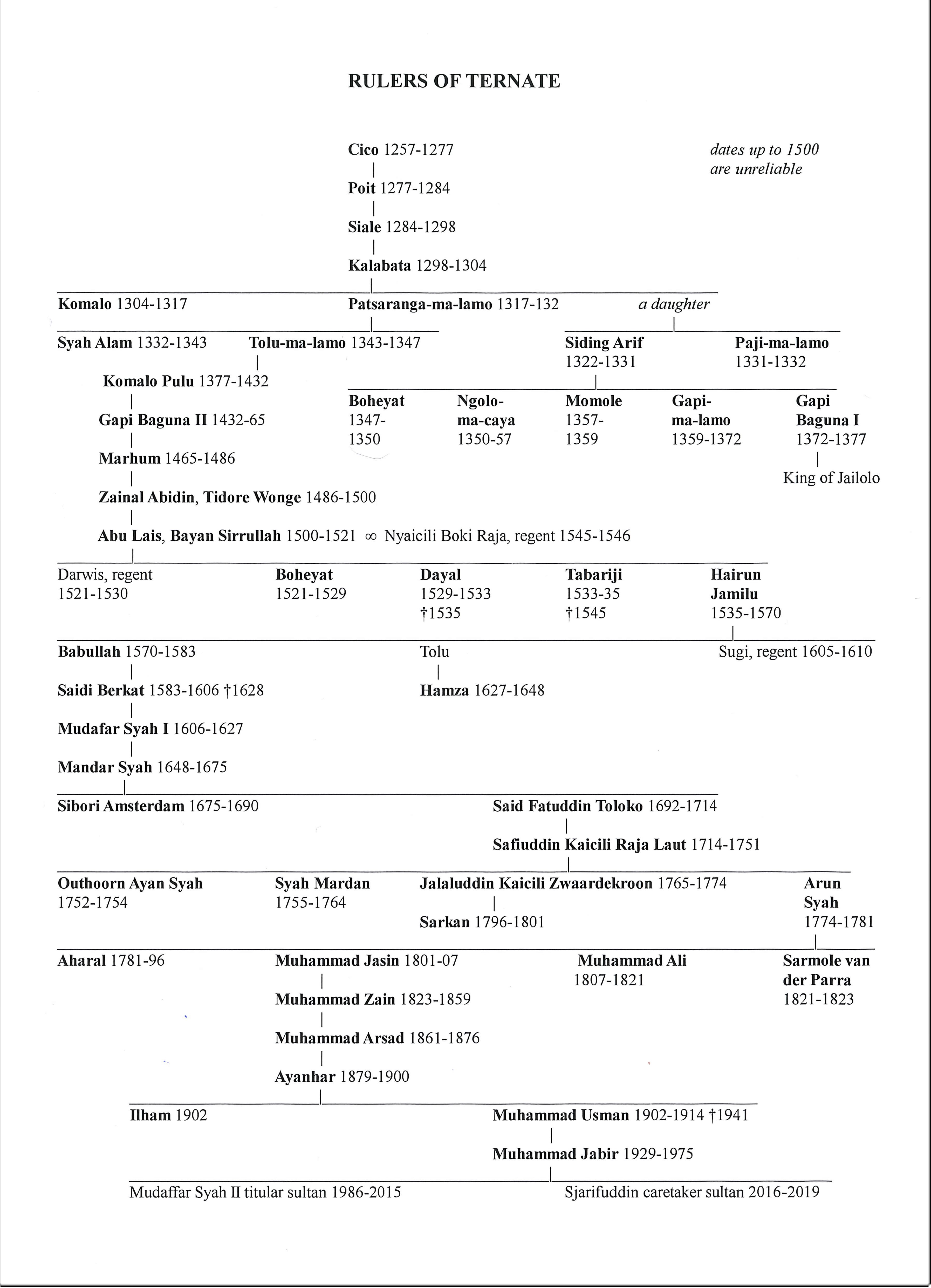
This is a list of rulers of Maluku from proto-historical times until the present. The four sultanates of Ternate, Tidore, Jailolo and Bacan were considered descendants of a legendary figure called Jafar Sadik and formed a ritual quadripartition. Drawing wealth from the spice production and trade with other parts of Asia, Ternate and Tidore lorded over extensive realms which stretched from Sulawesi to Papua, while Jailolo and Bacan merely had local significance. They fell under Portuguese or Spanish influence in the sixteenth century, superseded by Dutch impact in the seventeenth century. The sultanates were subordinated to the Dutch colonial state until 1942 when the Japanese occupied Indonesia. After the outbreak of the Indonesian revolution they belonged to the Dutch-approved quasi-state East Indonesia from 1946 to 1950 when they were incorporated in the unitary Indonesian state. Sultans of Bacan *Muhammad Bakir (c. 1465) on of Jafar Sadik*Zainal Abidin (late 15th century or e ... [...More Info...] [...Related Items...] OR: [Wikipedia] [Google] [Baidu] |


