|
José Darío Argüello
José Darío Argüello (1753–1828) was a Querétaro-born Californio politician, soldier, and ranchero. He served as interim Governor of Alta California and then a term as Governor of Baja California. Biography José Darío Argüello was born in 1753 in Santiago de Querétaro, New Spain (present day Mexico). Argüello enlisted in the Mexico regiment of dragoons, serving as a private, and later sergeant of the presidial company of Altar, Sonora. In 1781 he was promoted to ''alférez'' (sub-lieutenant) and commandant for what was to become the Presidio of Santa Barbara in Alta California. ;Founding Los Angeles Under orders from Governor Felipe de Neve, Argüello led the first ten Los Angeles Pobladores families and their livestock overland to settle. Military commander Fernando Rivera y Moncada led the guard, until killed during a civil resistance uprising by Quechan Indians near Yuma Crossing. Argüello and the settlers continued onward to Mission San Gabriel in today' ... [...More Info...] [...Related Items...] OR: [Wikipedia] [Google] [Baidu] |
José Joaquín De Arrillaga
José Joaquín de Arrillaga was a Basque officer who served twice as Governor of the Californias and as the first Governor of Alta California, following the partition of the Californias in 1804. He was the only Spanish-era governor to be buried in California. Governor Arrillaga served as captain in the Spanish army in northern Mexico and Texas in the 1780s and 1790s. He was the ''comandante'' at Loreto, Baja California Sur. He was reported to have been well-liked by all, known as an efficient and honest officer, and accordingly after the death of Governor José Antonio Roméu on April 9, 1792, Arrillaga was appointed acting Governor of California. He hoped to stay in Loreto and rule from there, but he was ordered to the capital in Monterey, California, and arrived in July 1793. To see the extent of the Spanish missions in California, he traveled north and visited missions and the Presidio of San Francisco, returning to the capital in September 1793. Arrillaga worked to make th ... [...More Info...] [...Related Items...] OR: [Wikipedia] [Google] [Baidu] |
Fernando Rivera Y Moncada
Fernando Javier Rivera y Moncada (c. 1725 – July 18, 1781) was a soldier of the Spanish Empire who served in The Californias (''Las Californias''), the far northwest frontier of New Spain. He participated in several early overland explorations and later served as third Governor of The Californias, from 1774 to 1777. History Mexico Rivera was born near Compostela, New Spain (now Mexico). His father, Don Cristóbal de Rivera, was locally prominent and a local office holder. Rivera was born of Don Cristóbal's second wife, Josefa Ramón de Moncada. Rivera had a total of 10 siblings and half-siblings; he was ninth in birth order. Rivera's pure Spanish blood but local birth made him a "criollo". Rivera entered military service in 1742, serving in Loreto, Baja California, at a time when the colonial settlement of that peninsula comprised mostly Jesuit missions. In 1751 Rivera was elevated over several older and higher ranking soldiers to the command of the presidio (military h ... [...More Info...] [...Related Items...] OR: [Wikipedia] [Google] [Baidu] |
San Francisco Peninsula
The San Francisco Peninsula is a peninsula in the San Francisco Bay Area that separates San Francisco Bay from the Pacific Ocean. On its northern tip is the City and County of San Francisco. Its southern base is Los Altos and Mountain View, in Santa Clara County, south of Palo Alto and north of Sunnyvale. Most of the Peninsula is occupied by San Mateo County, between San Francisco and Santa Clara counties, and including the cities and towns of Atherton, Belmont, Brisbane, Burlingame, Colma, Daly City, East Palo Alto, El Granada, Foster City, Half Moon Bay, Hillsborough, La Honda, Loma Mar, Los Altos, Los Altos Hills, Menlo Park, Millbrae, Mountain View, Pacifica, Palo Alto, Pescadero, Portola Valley, Redwood City, Redwood Shores, San Bruno, San Carlos, San Mateo, South San Francisco, West Menlo Park and Woodside. Whereas the term ''peninsula'' in a geographical sense technically refers to the entire San Francisco Peninsula, in local jargon, "The Pe ... [...More Info...] [...Related Items...] OR: [Wikipedia] [Google] [Baidu] |
Rancho De Las Pulgas
Rancho de las Pulgas was a 1795 Spanish land grant in present-day San Mateo County, California, to José Darío Argüello. The literal translation is "Ranch of the Fleas," named after the exceptional abundance of fleas in the area. The grant extended about one league from San Francisco Bay to the hills, and was bounded by San Mateo Creek on the north (which separated it from Rancho San Mateo) and San Francisquito Creek on the south (which separated it from Rancho San Francisquito and Rancho Rincon de San Francisquito). The grant encompassed present-day San Mateo, Belmont, San Carlos, Redwood City, Atherton and Menlo Park. The southern boundary of the Rancho at San San Francisquito Creek would later define the eastern portion of the southern boundary of San Mateo County. History In 1795, the Spanish Governor of California, Diego de Borica, made the provisional grant of the Las Pulgas to José Darío Argüello. Brothers Luis Antonio Argüello (1784–1830), Santi ... [...More Info...] [...Related Items...] OR: [Wikipedia] [Google] [Baidu] |
Ranchos Of California
In Alta California (now known as California) and Baja California, ranchos were concessions and land grants made by the Viceroyalty of New Spain, Spanish and History of Mexico, Mexican governments from 1775 to 1846. The Spanish concessions of land were made to retired soldiers as an inducement for them to settle in the frontier. These concessions reverted to the Spanish crown upon the death of the recipient. After independence, the Mexican government encouraged settlement in these areas by issuing much larger land grants to both native-born and naturalized Mexican citizens. The grants were usually two or more square league (unit), leagues, or in size. Unlike Spanish Concessions, Mexican land grants provided permanent, unencumbered ownership rights. Most ranchos granted by Mexico were located along the California coast around San Francisco Bay, inland along the Sacramento River, and within the San Joaquin Valley. When the Missions were secularized per the Mexican Secularizatio ... [...More Info...] [...Related Items...] OR: [Wikipedia] [Google] [Baidu] |
Diego De Borica
Diego de Borica (1742–1800) was a Basque colonial Governor of the Californias, from 1794 to 1800. Family Diego de Borica y Retegui was born in Vitoria-Gasteiz to a family connected to Father Fermín de Lasuén's. In 1780 Diego de Borica married Maria Magdalena de Urquidi, a Mexican-Basque direct descendant of one of the founders of Durango, Mexico. Military advance as governor As the governor, Diego de Borica and Father Lasuén determined that five more missions were needed in 1795 along El Camino Real. Borica sent expeditions from four different missions to find suitable new settlements that were no more than one day's travel as military escorts were necessary. By August 1796, Borica notified Viceroy Miguel de la Grúa Talamanca that no increase in troops was necessary. The first missionary site selected in 1796 was Mission San José near the pueblo of the same name. During Borica's tenure as governor, five missions were founded: Mission San José (June 11, 1797), M ... [...More Info...] [...Related Items...] OR: [Wikipedia] [Google] [Baidu] |
Presidio Of Monterey
The Presidio of Monterey (POM), located in Monterey, California, is an active US Army installation with historic ties to the Spanish colonial era. Currently, it is the home of the Defense Language Institute Foreign Language Center (DLI-FLC). It is the last and only presidio in California to have an active military installation. History The Spanish explorer Sebastián Vizcaíno visited, named and charted Monterey Bay (especially the southern end) in 1602. In his official report, Vizcaíno recommended the natural harbor he found as an appropriate site for a seaport, military fortification and colonization. It would be over 150 years, until news of Pacific Coast moves by Spain's European rivals brought the remote area back to the attention of the leaders of New Spain. José de Gálvez's grand plan In 1768, José de Gálvez, special deputy (''visitador'') of King Carlos III in New Spain (Mexico), received this order: "Occupy and fortify San Diego and Monterey for God and the K ... [...More Info...] [...Related Items...] OR: [Wikipedia] [Google] [Baidu] |
Presidio Of San Francisco
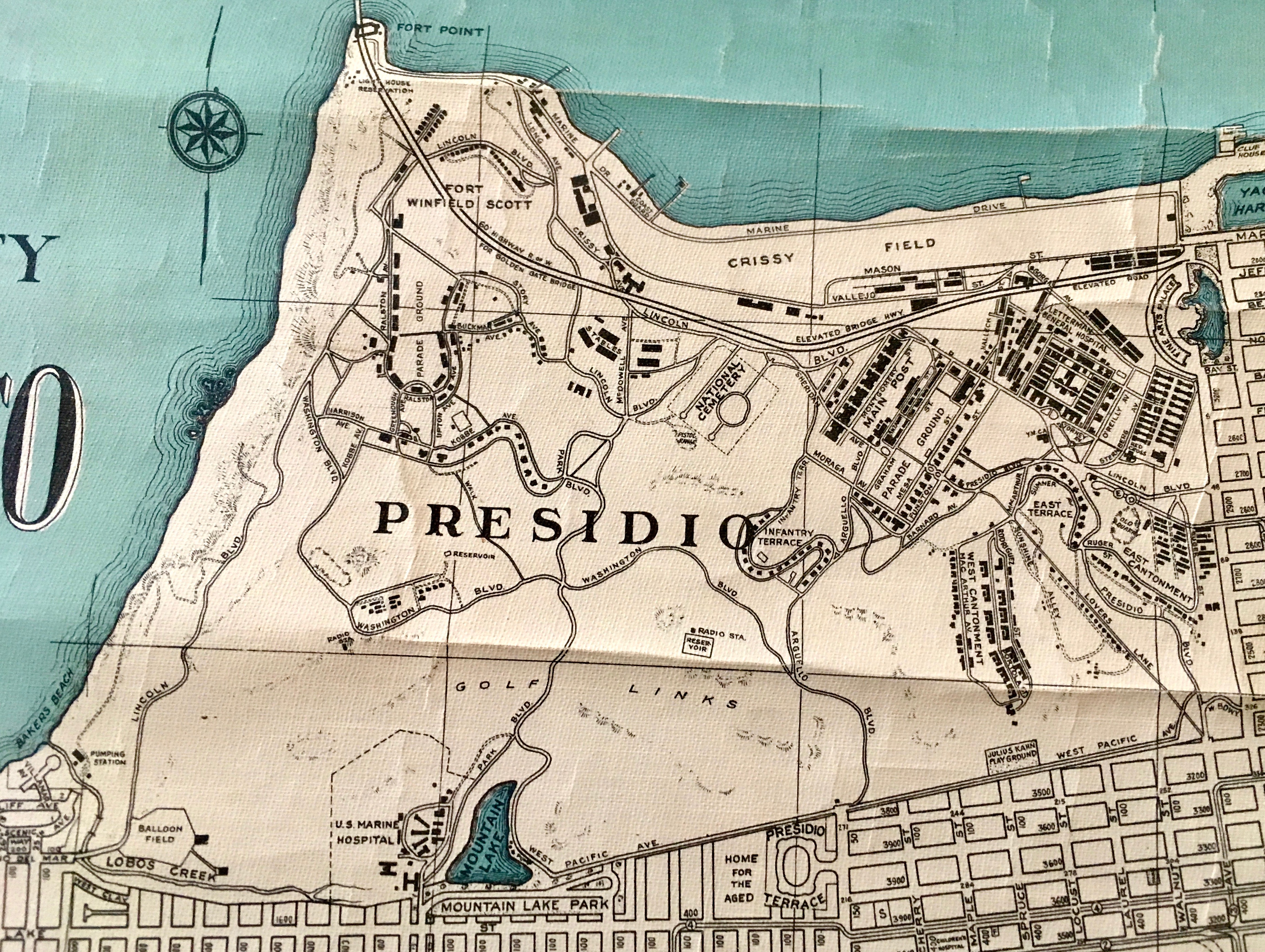
The Presidio of San Francisco (originally, El Presidio Real de San Francisco or The Royal Fortress of Saint Francis) is a park and former U.S. Army post on the northern tip of the San Francisco Peninsula in San Francisco, California, and is part of the Golden Gate National Recreation Area. It had been a fortified location since September 17, 1776, when New Spain established the presidio to gain a foothold in Alta California and the San Francisco Bay. It passed to Mexico in 1820, which in turn passed it to the United States in 1848. As part of a military reduction program under the Base Realignment and Closure (Base Realignment and Closure Commission, BRAC) process from 1988, Congress voted to end the Presidio's status as an active military installation of the U.S. Army. On October 1, 1994, it was transferred to the National Park Service, ending 219 years of military use and beginning its next phase of mixed commercial and public use. In 1996, the United States Congress created th ... [...More Info...] [...Related Items...] OR: [Wikipedia] [Google] [Baidu] |
Los Angeles, California
Los Angeles, often referred to by its initials L.A., is the List of municipalities in California, most populous city in the U.S. state of California, and the commercial, Financial District, Los Angeles, financial, and Culture of Los Angeles, cultural center of Southern California. With an estimated 3,878,704 residents within the city limits , it is the List of United States cities by population, second-most populous in the United States, behind only New York City. Los Angeles has an Ethnic groups in Los Angeles, ethnically and culturally diverse population, and is the principal city of a Metropolitan statistical areas, metropolitan area of 12.9 million people (2024). Greater Los Angeles, a combined statistical area that includes the Los Angeles and Riverside–San Bernardino metropolitan areas, is a sprawling metropolis of over 18.5 million residents. The majority of the city proper lies in Los Angeles Basin, a basin in Southern California adjacent to the Pacific Ocean in the ... [...More Info...] [...Related Items...] OR: [Wikipedia] [Google] [Baidu] |
Los Angeles River
The Los Angeles River (), historically known as by the Tongva and the by the Spanish, is a major river in Los Angeles County, California. Its headwaters are in the Simi Hills and Santa Susana Mountains, and it flows nearly from Canoga Park, Los Angeles, California, Canoga Park through the San Fernando Valley, downtown Los Angeles, and the Gateway Cities to its mouth in Long Beach, California, Long Beach, where it flows into San Pedro Bay (California), San Pedro Bay. While the river was once free-flowing and frequently flooding, forming alluvial flood plains along its banks, it currently flows through a concrete channel on a fixed course, which was built after a series of devastating floods in the early 20th century. Before the opening of the Los Angeles Aqueduct, the river was the primary source of fresh water for the city. Although the Los Angeles region still receives some water from the river and other local sources, most of the water supply flows from several aqueducts ... [...More Info...] [...Related Items...] OR: [Wikipedia] [Google] [Baidu] |
Pueblo De Los Angeles
Pueblo refers to the settlements of the Pueblo peoples, Native American tribes in the Southwestern United States, currently in New Mexico, Arizona, and Texas. The permanent communities, including some of the oldest continually occupied settlements in the United States, are called pueblos (lowercased). Spanish explorers of northern New Spain used the term ''pueblo'' to refer to permanent Indigenous towns they found in the region, mainly in New Mexico and parts of Arizona, in the former province of Nuevo México. This term continued to be used to describe the communities housed in apartment structures built of stone, adobe, and other local material. The structures were usually multistoried buildings surrounding an open plaza. Many rooms were accessible only through ladders raised and lowered by the inhabitants, thus protecting them from break-ins and unwanted guests. Larger pueblos are occupied by hundreds to thousands of Puebloan people. Several federally recognized tribes have ... [...More Info...] [...Related Items...] OR: [Wikipedia] [Google] [Baidu] |
San Gabriel Valley
The San Gabriel Valley (), sometimes referred to by its initials as SGV, is one of the principal valleys of Southern California, with the city of Los Angeles directly bordering it to the west and occupying the vast majority of the southeastern part of Los Angeles County. Surrounding landforms and other features include: * the San Gabriel Mountains to the north; * the San Rafael Hills to the west, with the Los Angeles Basin beyond; * the Crescenta Valley to the northwest; * the Puente Hills to the south, with the coastal plain of Orange County, California, Orange County beyond; * the Chino Hills and San Jose Hills to the east, with the Pomona Valley and Inland Empire (CA), Inland Empire beyond; and * the city limits of Los Angeles bordering its western edge. The San Gabriel Valley derives its name from the San Gabriel River (California), San Gabriel River that flows southward through the center of the valley, which itself was named for the Spanish Mission San Gabriel Arcángel ... [...More Info...] [...Related Items...] OR: [Wikipedia] [Google] [Baidu] |


