|
John Todd (Virginia Soldier)
John Todd (March 27, 1750 – August 19, 1782) was an American military officer and politician who fought during the Revolutionary War and became the first administrator of the Illinois County of the U.S. state of Virginia before that state ceded the territory to the federal government. Early life Todd was born in Montgomery County, Pennsylvania, the son of David Todd and the brother of Robert and Levi Todd, the latter being grandfather of Mary Todd Lincoln. He was educated in Virginia at a school run by his uncle, the Rev. John Todd. After obtaining a license to practice law, Todd settled in Fincastle, Virginia. Career In 1774, Todd served in the Battle of Point Pleasant, which was fought near present-day Point Pleasant, West Virginia and is celebrated in West Virginia as the first battle in the American Revolutionary War. He was then drawn west into the recently opened frontier of Kentucky where he purchased land near Lexington. Todd served in the Virginia legislature in ... [...More Info...] [...Related Items...] OR: [Wikipedia] [Google] [Baidu] |
Montgomery County, Pennsylvania
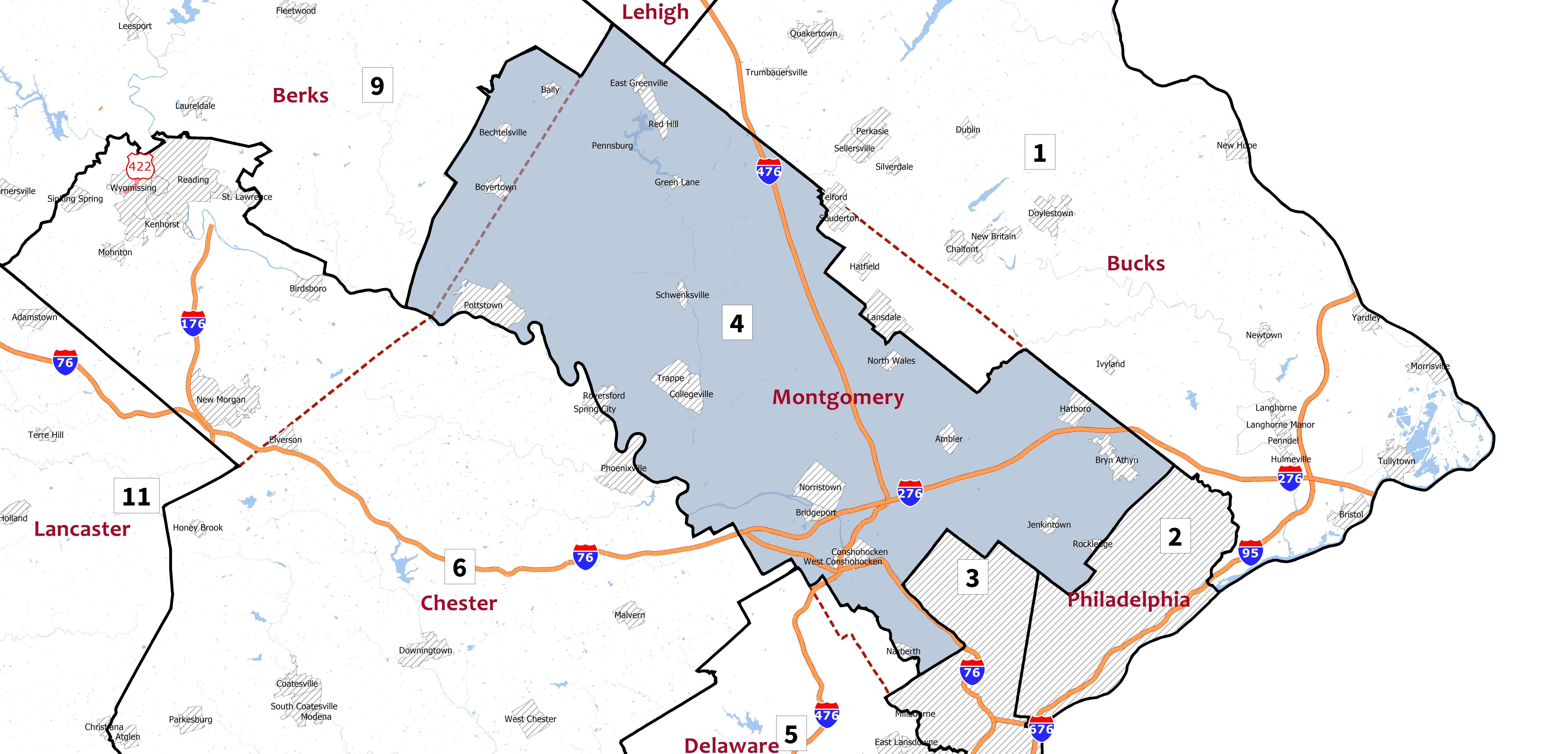
Montgomery County is a county in the Commonwealth of Pennsylvania. It is the third-most populous county in Pennsylvania and the 73rd-most populous county in the United States. As of the 2020 census, the population of the county was 856,553, representing a 7.1% increase from the 799,884 residents enumerated in the 2010 census. Montgomery County is located adjacent to and northwest of Philadelphia. The county seat and largest city is Norristown. Montgomery County is geographically diverse, ranging from farms and open land in the extreme north of the county to densely populated suburban neighborhoods in the southern and central portions of the county. Montgomery County is included in the Philadelphia- Camden- Wilmington PA- NJ- DE- MD metropolitan statistical area, sometimes expansively known as the Delaware Valley. The county marks part of the Delaware Valley's northern border with the Lehigh Valley region of Pennsylvania. In 2010, Montgomery County was the 66th-wealthiest ... [...More Info...] [...Related Items...] OR: [Wikipedia] [Google] [Baidu] |
George Rogers Clark
George Rogers Clark (November 19, 1752 – February 13, 1818) was an American surveyor, soldier, and militia officer from Virginia who became the highest-ranking American patriot military officer on the northwestern frontier during the American Revolutionary War. He served as leader of the militia in Kentucky (then part of Virginia) throughout much of the war. He is best known for his captures of Kaskaskia (1778) and Vincennes (1779) during the Illinois Campaign, which greatly weakened British influence in the Northwest Territory. The British ceded the entire Northwest Territory to the United States in the 1783 Treaty of Paris, and Clark has often been hailed as the "Conqueror of the Old Northwest". Clark's major military achievements occurred before his thirtieth birthday. Afterward, he led militia in the opening engagements of the Northwest Indian War, but was accused of being drunk on duty. He was disgraced and forced to resign, despite his demand for a formal investiga ... [...More Info...] [...Related Items...] OR: [Wikipedia] [Google] [Baidu] |
Todd County, Kentucky
Todd County is a county located in the U.S. state of Kentucky. As of the 2010 census, the population was 12,460. Its county seat is Elkton. The county is named for Colonel John Todd, who was killed at the Battle of Blue Licks in 1782 during the American Revolution. History Early history Todd County consists of two geographical regions known historically as the high country to the north and low country to the south. The northern highlands consist of steep-sloped sandstone terrain with forests of oak, walnut and poplar. The landscape contains steep bluffs and sharp rises and falls within the terrain. The southern lowlands consist of rolling limestone flatlands void of aquifer sinks and consist of dense but sparse forests of oak, walnut poplar and ash. The historic inhabitants of the region before European encounter were the Iroquoian language-speaking Cherokee, who had migrated centuries earlier from areas around the Great Lakes. They used the lands for hunting and gathering.Pe ... [...More Info...] [...Related Items...] OR: [Wikipedia] [Google] [Baidu] |
Battle Of Blue Licks
The Battle of Blue Licks, fought on August 19, 1782, was one of the last battles of the American Revolutionary War. The battle occurred ten months after Lord Cornwallis's surrender at Yorktown, which had effectively ended the war in the east. On a hill next to the Licking River in what is now Robertson County, Kentucky (then Fayette County, Virginia), a force of about 50 Loyalists along with 300 indigenous warriors ambushed and routed 182 Kentucky militiamen, who were partially led by Daniel Boone. It was the last victory for the Loyalists and natives during the frontier war. British, Loyalist and Native forces would engage in fighting with American forces once more the following month in Wheeling, West Virginia, during the Siege of Fort Henry. Background Caldwell's expedition Although the main British Army under Lord Cornwallis had surrendered at Yorktown in October 1781, virtually ending the war in the east, fighting on the western frontier continued. Aided by the Brit ... [...More Info...] [...Related Items...] OR: [Wikipedia] [Google] [Baidu] |
Daniel Boone
Daniel Boone (September 26, 1820) was an American pioneer and frontiersman whose exploits made him one of the first folk heroes of the United States. He became famous for his exploration and settlement of Kentucky, which was then beyond the western borders of the Thirteen Colonies. In 1775, Boone blazed the Wilderness Road through the Cumberland Gap and into Kentucky, in the face of resistance from American Indians, for whom Kentucky was a traditional hunting ground. He founded Boonesborough, one of the first English-speaking settlements west of the Appalachian Mountains. By the end of the 18th century, more than 200,000 people had entered Kentucky by following the route marked by Boone. Boone served as a militia officer during the Revolutionary War (1775–1783), which was fought in Kentucky primarily between American settlers and British-allied Indians. Boone was taken in by Shawnees in 1778 and adopted into the tribe, but he resigned and continued to help protect the Ken ... [...More Info...] [...Related Items...] OR: [Wikipedia] [Google] [Baidu] |
Fayette County, Kentucky
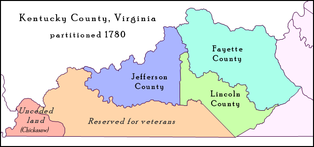
Fayette County is located in the central part of the U.S. state of Kentucky. As of the 2020 census, the population was 322,570, making it the second-most populous county in the commonwealth. Its territory, population and government are coextensive with the city of Lexington, which also serves as the county seat. Fayette County is part of the Lexington–Fayette, KY Metropolitan Statistical Area. History Fayette County—originally Fayette County, Virginia—was established by the Virginia General Assembly in June 1780, when it abolished and subdivided Kentucky County into three counties: Fayette, Jefferson and Lincoln. Together, these counties and those set off from them later in that decade separated from Virginia in 1792 to become the Commonwealth of Kentucky. Originally, Fayette County included land which makes up 37 present-day counties and parts of 7 others. It was reduced to its present boundaries in 1799. The county is named for the Marquis de LaFayette, who came to ... [...More Info...] [...Related Items...] OR: [Wikipedia] [Google] [Baidu] |
Jefferson County, Kentucky
Jefferson County is located in the north central portion of the U.S. state of Kentucky. As of the 2020 census, the population was 782,969. It is the most populous county in the commonwealth (with more than twice the population of second ranked Fayette County). Since a city-county merger in 2003, the county's territory, population and government have been coextensive with the city of Louisville, which also serves as county seat. The administrative entity created by this merger is the Louisville/Jefferson County Metro Government, abbreviated to Louisville Metro. Jefferson County is the anchor of the Louisville-Jefferson County, KY-IN Metropolitan Statistical Area, locally referred to as Kentuckiana. History Jefferson County—originally Jefferson County, Virginia—was established by the Virginia General Assembly in June 1780, when it abolished and partitioned Kentucky County into three counties: Fayette, Jefferson and Lincoln. Named for Thomas Jefferson, who was governor ... [...More Info...] [...Related Items...] OR: [Wikipedia] [Google] [Baidu] |
Lincoln County, Kentucky
Lincoln County is a county located in south-central Kentucky. As of the 2020 census, the population was 24,275. Its county seat is Stanford. Lincoln County is part of the Danville, KY Micropolitan Statistical Area. History Lincoln County—originally Lincoln County, Virginia—was established by the Virginia General Assembly in June 1780, and named in honor of Revolutionary War general Benjamin Lincoln. It was one of three counties formed out of Virginia's Kentucky County (The other two were Fayette and Jefferson), and is one of Kentucky's nine original counties. The county's original seat was at Harrodsburg; but in 1785, Lincoln County was partitioned, and Harrodsburg became the seat of the new Mercer County. Afterward, Stanford became Lincoln County's permanent seat. Geography According to the United States Census Bureau, the county has a total area of , of which is land and (0.7%) is water. Lincoln County is located in south-central Kentucky astride the southern ... [...More Info...] [...Related Items...] OR: [Wikipedia] [Google] [Baidu] |
Kentucky County, Virginia
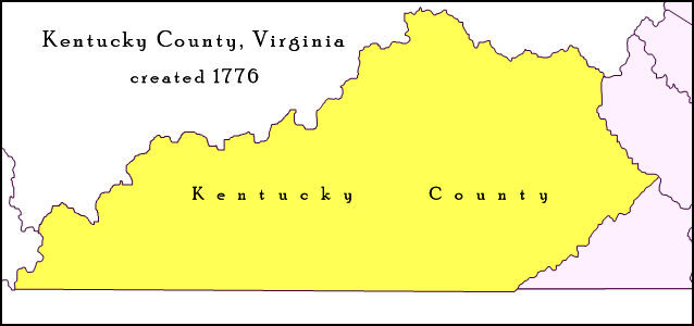
Kentucky County (then alternately spelled Kentucke County) was formed by the Commonwealth of Virginia from the western portion (beyond the Cumberland Mountains) of Fincastle County effective December 31, 1776. The name of the county was taken from a Native American place name that came to be associated with a river in east central Kentucky, and gave the Kentucky River its name. During the three and one-half years of Kentucky County's existence, its seat of government was Harrodstown (then also known as Oldtown, later renamed Harrodsburg). Kentucky County was abolished on June 30, 1780, when it was divided into Fayette, Jefferson, and Lincoln counties. Afterward, these counties and those set off from them later in that decade were designated collectively as the District of Kentucky by the Virginia House of Delegates. The counties of the district frequently petitioned both the Virginia legislature and the Continental Congress seeking statehood. Finally successful, the Commo ... [...More Info...] [...Related Items...] OR: [Wikipedia] [Google] [Baidu] |
Richmond, Virginia
(Thus do we reach the stars) , image_map = , mapsize = 250 px , map_caption = Location within Virginia , pushpin_map = Virginia#USA , pushpin_label = Richmond , pushpin_map_caption = Location within Virginia##Location within the contiguous United States , pushpin_relief = yes , coordinates = , subdivision_type = Country , subdivision_name = , subdivision_type1 = U.S. state, State , subdivision_name1 = , established_date = 1742 , , named_for = Richmond, London, Richmond, United Kingdom , government_type = , leader_title = List of mayors of Richmond, Virginia, Mayor , leader_name = Levar Stoney (Democratic Party (United States), D) , total_type = City , area_magnitude = 1 E8 , area_total_sq_mi = 62.57 , area_land_sq_mi = 59.92 , area_ ... [...More Info...] [...Related Items...] OR: [Wikipedia] [Google] [Baidu] |
Northwest Territory
The Northwest Territory, also known as the Old Northwest and formally known as the Territory Northwest of the River Ohio, was formed from unorganized western territory of the United States after the American Revolutionary War. Established in 1787 by the Congress of the Confederation through the Northwest Ordinance, it was the nation's first post-colonial organized incorporated territory. At the time of its creation, the territory included all the land west of Pennsylvania, northwest of the Ohio River and east of the Mississippi River below the Great Lakes, and what later became known as the Boundary Waters. The region was ceded to the United States in the Treaty of Paris of 1783. Throughout the Revolutionary War, the region was part of the British Province of Quebec. It spanned all or large parts of six eventual U.S. states (Ohio, Indiana, Illinois, Michigan, Wisconsin, and the northeastern part of Minnesota). Reduced to present-day Ohio, eastern Michigan and a sliver of sout ... [...More Info...] [...Related Items...] OR: [Wikipedia] [Google] [Baidu] |
United Kingdom
The United Kingdom of Great Britain and Northern Ireland, commonly known as the United Kingdom (UK) or Britain, is a country in Europe, off the north-western coast of the continental mainland. It comprises England, Scotland, Wales and Northern Ireland. The United Kingdom includes the island of Great Britain, the north-eastern part of the island of Ireland, and many smaller islands within the British Isles. Northern Ireland shares a land border with the Republic of Ireland; otherwise, the United Kingdom is surrounded by the Atlantic Ocean, the North Sea, the English Channel, the Celtic Sea and the Irish Sea. The total area of the United Kingdom is , with an estimated 2020 population of more than 67 million people. The United Kingdom has evolved from a series of annexations, unions and separations of constituent countries over several hundred years. The Treaty of Union between the Kingdom of England (which included Wales, annexed in 1542) and the Kingdom of Scotland in 170 ... [...More Info...] [...Related Items...] OR: [Wikipedia] [Google] [Baidu] |


