|
Jawor (mountain)
Jawor is a peak and massif in the Sanocko-TurczaŇĄskie Mountains, located next to the Lake Solina. ŇĀoboŇļnicy valley is surrounding the peak and Lake Solina by the Gulf of TeleŇõnicka, while to the East the ŇĽuk√≥w mountain range is separated by a pass at 530 metres. From the top of the main peak where the TON G√≥ra Jawor radio mast is located, two ridges from the North-Eastern and South-Western points come off with culminations of 702 and 608 metres. By the side of the Jawor reservoir is a complex of leisure facilities and buildings. ŇĀobozew Dolny ŇĀobozew Dolny is a village in the administrative district of Gmina Ustrzyki Dolne, within Bieszczady County, Subcarpathian Voivodeship, in south-eastern Poland. It lies approximately south-west of Ustrzyki Dolne and south-east of the regional c ... has an asphalt road connection which weaves around the mountain up to 700 metres, and steadily declines down to the complex. On the South-Western slope, close by next to the p ... [...More Info...] [...Related Items...] OR: [Wikipedia] [Google] [Baidu] |
Sanocko-TurczaŇĄskie Mountains
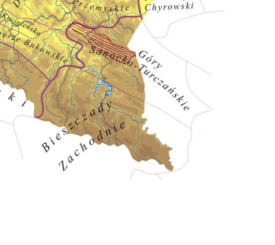
The Sanok-Turka Mountains ( pl, G√≥ry Sanocko-TurczaŇĄskie; uk, –°—Ź–Ĺ–ĺ—Ü—Ć–ļ–ĺ-–Ę—É—Ä—á–į–Ĺ—Ā—Ć–ļ—Ė –≥–ĺ—Ä–ł) are a mountain range in the Eastern Beskids, within the Outer Eastern Carpathians. They are located in southern border section between Poland and Ukraine . The Sanok-Turka mountain range stretches on an area of 930 km¬≤ to the north of the Bieszczady Mountains, and to the south of the Przemyskie Upland, between the valleys of the middle San and Stryi River. They extend after the river Stryi by the Beskidy BrzeŇľne. The northern boundary is made by the rivers Wiar, ŇĀomna, Stupnica, Leszczawka, Lachawka and Tyrawski, the western valley of the river San. Sometimes the territories to the East and South of the river Wiar, (like the Sucha Obycz Massif), and the east of the Lachawka river valley to the valley of the river San (Wysokiego mountain range) are added to Sanocko-TurczaŇĄskie mountains (there are also different variations of the northern border). The south ... [...More Info...] [...Related Items...] OR: [Wikipedia] [Google] [Baidu] |
Lake Solina
Lake Solina ( pl, Jezioro SoliŇĄskie) is an artificial lake in the Bieszczady Mountains region, more precisely in Lesko County of the Subcarpathian Voivodship of Poland. Its coordinates are . The lake was created in 1968 by the construction of the Solina Dam on the San River. It has an area of and contains of water, making it Poland's largest artificial lake. It is the best known tourist attraction of the region, with waterside villages like Solina, Myczkowce and PolaŇĄczyk catering to watersports enthusiasts. The lake's great depth, water clarity Water clarity is a descriptive term for how deeply visible light penetrates through water. In addition to light penetration, the term water clarity is also often used to describe underwater visibility. Water clarity is one way that humans measure ..., and mountainous scenery makes it a very popular destination. The lake is also known as the ''Bieszczady Sea''. Starting in the 1970s the Wojew√≥dzkie Przedsińôbiorstwo Turystyczn ... [...More Info...] [...Related Items...] OR: [Wikipedia] [Google] [Baidu] |
ŇĀobozew Dolny
ŇĀobozew Dolny is a village in the administrative district of Gmina Ustrzyki Dolne, within Bieszczady County, Subcarpathian Voivodeship, in south-eastern Poland. It lies approximately south-west of Ustrzyki Dolne and south-east of the regional capital Rzesz√≥w Rzesz√≥w ( , ; la, Resovia; yi, ◊®◊ô◊ô◊©◊ź ''Raisha'')) is the largest city in southeastern Poland. It is located on both sides of the WisŇāok River in the heartland of the Sandomierz Basin. Rzesz√≥w has been the capital of the Subcarpathian Vo .... Nearby to the south is the 741-metre Jawor mountain peak. References Villages in Bieszczady County {{Bieszczady-geo-stub ... [...More Info...] [...Related Items...] OR: [Wikipedia] [Google] [Baidu] |


