|
Issaouane Erg
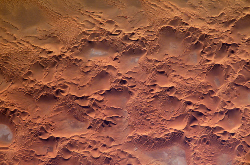
The Issaouane Erg (also called Issaouane-N-Irrararene) is an approximately 38,000 km2 erg (sand sea) in Algeria's portion of the Sahara desert, located at . Topography The Issaouane Erg is located near the Ahaggar Mountains. It is part of a major dune field that extends from Issaouane Erg in the north to the Sudanese Erg in the south, flanked by the Libyan erg of Murzuq. In the north, the Issaouane Erg ends at the Tinrhert Plateau and in the south at the Fadnoun Plateau. To a large extent it follows the 500-m contour of the surrounding landscape, ergs mostly being confined to basins. Sand in the Issaouane Erg, below the level of the sand dunes, has accumulated to a depth of 20 to 30 meters. It has barchan dunes as well as star dunes of 300 to 430 meters high. The presence of both barchan dunes (which form due to unidirectional winds) and star dunes (which form when winds from various directions deposit sand) "suggests that wind regimes have changed over time". NASA's ''Earth ... [...More Info...] [...Related Items...] OR: [Wikipedia] [Google] [Baidu] |
Erg (landform)
An erg (also sand sea or dune sea, or sand sheet if it lacks dunes) is a broad, flat area of desert covered with wind-swept sand with little or no vegetative cover. The word is derived from the Arabic word ''ʿarq'' (), meaning "dune field". Strictly speaking, an erg is defined as a desert area that contains more than of aeolian or wind-blown sand and where sand covers more than 20% of the surface. Smaller areas are known as "dune fields". The largest hot desert in the world, the Sahara, covers and contains several ergs, such as the Chech Erg and the Issaouane Erg in Algeria. Approximately 85% of all the Earth's mobile sand is found in ergs that are greater than . Ergs are also found on other celestial bodies, such as Venus, Mars, and Saturn's moon Titan. Description Ergs are concentrated in two broad belts between 20° to 40°N and 20° to 40°S latitudes, which include regions crossed by the dry, subsiding air of the trade winds. Active ergs are limited to regions ... [...More Info...] [...Related Items...] OR: [Wikipedia] [Google] [Baidu] |
Iron Oxide
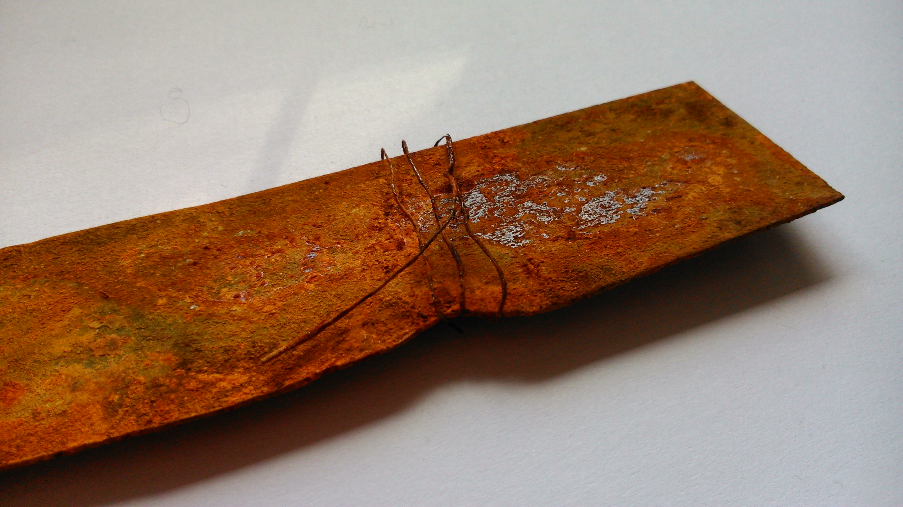
Iron oxides are chemical compounds composed of iron and oxygen. Several iron oxides are recognized. All are black magnetic solids. Often they are non-stoichiometric. Oxyhydroxides are a related class of compounds, perhaps the best known of which is rust. Iron oxides and oxyhydroxides are widespread in nature and play an important role in many geological and biological processes. They are used as iron ores, pigments, catalysts, and in thermite, and occur in hemoglobin. Iron oxides are inexpensive and durable pigments in paints, coatings and colored concretes. Colors commonly available are in the "earthy" end of the yellow/orange/red/brown/black range. When used as a food coloring, it has E number E172. Stoichiometries Iron oxides feature as ferrous ( Fe(II)) or ferric ( Fe(III)) or both. They adopt octahedral or tetrahedral coordination geometry. Only a few oxides are significant at the earth's surface, particularly wüstite, magnetite, and hematite. * Oxides of FeII ... [...More Info...] [...Related Items...] OR: [Wikipedia] [Google] [Baidu] |
Landforms Of Algeria
A landform is a natural or anthropogenic land feature on the solid surface of the Earth or other planetary body. Landforms together make up a given terrain, and their arrangement in the landscape is known as topography. Landforms include hills, mountains, canyons, and valleys, as well as shoreline features such as bays, peninsulas, and seas, including submerged features such as mid-ocean ridges, volcanoes, and the great ocean basins. Physical characteristics Landforms are categorized by characteristic physical attributes such as elevation, slope, orientation, stratification, rock exposure and soil type. Gross physical features or landforms include intuitive elements such as berms, mounds, hills, ridges, cliffs, valleys, rivers, peninsulas, volcanoes, and numerous other structural and size-scaled (e.g. ponds vs. lakes, hills vs. mountains) elements including various kinds of inland and oceanic waterbodies and sub-surface features. Mountains, hills, plateaux, and plains are t ... [...More Info...] [...Related Items...] OR: [Wikipedia] [Google] [Baidu] |
List Of Ergs
In geomorphology, an erg is a large desert region of sand dunes with little or no vegetation,it is divided into 3 parts back erg ,central erg,fore erg, especially in the Sahara. This is a list of ergs around the world. Africa ;Algeria * Grand Erg Oriental (extends into Tunisia) * Grand Erg Occidental * Erg Chech (extends into Mali) * Erg Iguidi (extends into Mauritania) * Erg Issaouane * Erg er-Raoui * Erg Tiferine * Erg Tidohaine * Erg Merhiti * Erg Admer ; Botswana * Kalahari Desert ; Chad * Erg Djourab * Erg Idrisi ; Egypt * Black Desert * Erg Abunugar * Erg Abu Muharrik * Erg Abu Ramada * Gilf Kebir * Ramla el Kebir * Erg Somaya * Negev Desert (extends into Israel) * Great Sand Sea Desert * White Desert ; Libya * Erg Awbari * Erg Ubari * Erg Titersine * Erg Idehan Murzuq * Erg Ouan Kasa * Erg Tannezouft * Erg Takarkouri * Erg Mehedjibat * Erg Tassegefit * Calanshio Sand Sea * Rebiana Sand Sea ; Mali * Erg Achaif * Erg Aoukar (extends into Mauritania) * Erg ... [...More Info...] [...Related Items...] OR: [Wikipedia] [Google] [Baidu] |
Geography Of Algeria
Algeria comprises square kilometers of land, more than 80% of which is desert, in North Africa, between Morocco and Tunisia. It is the largest country in Africa. Its Arabic name, Al Jazair (the islands), is believed to derive from the rocky islands along the coastline of the Mediterranean Sea. The northern portion, an area of mountains, valleys, and plateaus between the Mediterranean and the Sahara Desert, forms an integral part of the section of North Africa known as the Maghreb. This area includes Morocco, Tunisia, and the northwestern portion of Libya known historically as Tripolitania. Size and boundaries Land boundaries:''Total:'' ''Border countries:'' Libya , Mali , Mauritania , Morocco , Niger , Tunisia , Western Sahara . Area – comparative: slightly larger than the Democratic Republic of the Congo and Saudi Arabia Coastline: Maritime claims: ''Territorial sea:'' , ''contiguous zone'': ''; exclusive fishing zone:'' Geographic regions The Tell The fertile Tel ... [...More Info...] [...Related Items...] OR: [Wikipedia] [Google] [Baidu] |
Repsol
Repsol S.A. El Nuevo Herald, 2012-05-31Originally an initialism for ''Refinería de Petróleos de '' adding the word ''Sol'' (Sun) () is a Spanish multinational energy and petrochemical company based in . It is engaged in worldwide and |
Korea
Korea ( ko, 한국, or , ) is a peninsular region in East Asia. Since 1945, it has been divided at or near the 38th parallel, with North Korea (Democratic People's Republic of Korea) comprising its northern half and South Korea (Republic of Korea) comprising its southern half. Korea consists of the Korean Peninsula, Jeju Island, and several minor islands near the peninsula. The peninsula is bordered by China to the northwest and Russia to the northeast. It is separated from Japan to the east by the Korea Strait and the Sea of Japan (East Sea). During the first half of the 1st millennium, Korea was divided between three states, Goguryeo, Baekje, and Silla, together known as the Three Kingdoms of Korea. In the second half of the 1st millennium, Silla defeated and conquered Baekje and Goguryeo, leading to the "Unified Silla" period. Meanwhile, Balhae formed in the north, superseding former Goguryeo. Unified Silla eventually collapsed into three separate states due to ... [...More Info...] [...Related Items...] OR: [Wikipedia] [Google] [Baidu] |
Sonatrach
Sonatrach ( ar, سوناطراك; french: Société Nationale pour la Recherche, la Production, le Transport, la Transformation, et la Commercialisation des Hydrocarbures) is the national state-owned oil company of Algeria. Founded in 1963, it is known today to be the largest company in Africa with 154 subsidiaries, and often referred as the first African oil "major". In 2021, Sonatrach was the seventh largest gas company in the world. Overview Sonatrach is the 12th largest oil consortium in the world, with 154 subsidiaries operating over the entire oil value-chain from upstream, to midstream, and downstream activities. In 2002, its gross sales was 1,530 billion Algerian dinars for a net income of 175 billion. With approximately 120,000 workers, the company produced 30% of the GNP of Algeria. Annually it produced 206 million Tonne of Oil equivalent (ToE), including 24 million ToE, or 11.7% of total, for the Algerian domestic market. In 2021, the company's export revenues had ... [...More Info...] [...Related Items...] OR: [Wikipedia] [Google] [Baidu] |
Kiffian Culture
The Kiffian culture is a prehistoric industry, or domain, that existed between approximately 8,000 BC and 6,000 BC in the Sahara Desert, during the African humid period referred to as the Neolithic Subpluvial. Human remains from this culture were found in 2000 AD at a site known as Gobero, located in Niger in the Ténéré Desert. The site is known as the largest and earliest burial place of Stone Age people in the Sahara desert. Characteristics The Kiffians were skilled hunters. Bones of many large savannah animals that were discovered in the same area suggest that they lived on the shores of a lake that was present during the Holocene Wet Phase, a period when the Sahara desert was verdant and wet. The Kiffian people were tall, standing over six feet in height. A craniometric analysis by Sereno et al. suggests that this early Holocene population was related to the Late Pleistocene Iberomaurusians and early Holocene Capsians of the Maghreb, as well as mid-Holocene Mechta gro ... [...More Info...] [...Related Items...] OR: [Wikipedia] [Google] [Baidu] |
Neolithic
The Neolithic period, or New Stone Age, is an Old World archaeological period and the final division of the Stone Age. It saw the Neolithic Revolution, a wide-ranging set of developments that appear to have arisen independently in several parts of the world. This "Neolithic package" included the introduction of farming, domestication of animals, and change from a hunter-gatherer lifestyle to one of settlement. It began about 12,000 years ago when farming appeared in the Epipalaeolithic Near East, and later in other parts of the world. The Neolithic lasted in the Near East until the transitional period of the Chalcolithic (Copper Age) from about 6,500 years ago (4500 BC), marked by the development of metallurgy, leading up to the Bronze Age and Iron Age. In other places the Neolithic followed the Mesolithic (Middle Stone Age) and then lasted until later. In Ancient Egypt, the Neolithic lasted until the Protodynastic period, 3150 BC.Karin Sowada and Peter Grave. Egypt in th ... [...More Info...] [...Related Items...] OR: [Wikipedia] [Google] [Baidu] |
Sabkha
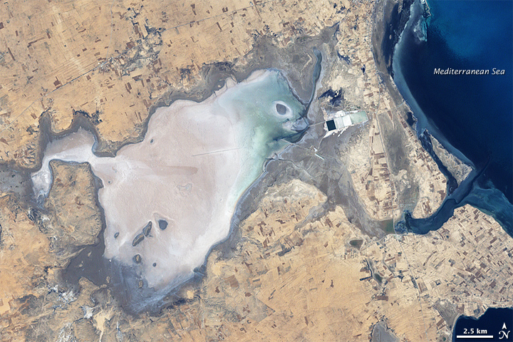
A sabkha ( ar, سبخة) is a coastal, supratidal mudflat or sandflat in which evaporite-saline minerals accumulate as the result of semiarid to arid climate. Sabkhas are gradational between land and intertidal zone within restricted coastal plains just above normal high-tide level. Within a sabkha, evaporite-saline minerals sediments typically accumulate below the surface of mudflats or sandflats. Evaporite-saline minerals, tidal-flood, and aeolian deposits characterize many sabkhas found along modern coastlines. The accepted type locality for a sabkha is at the southern coast of the Persian Gulf, in the United Arab Emirates.Neuendorf, K.K.E., J.P. Mehl, Jr., and J.A. Jackson, eds. (2005) ''Glossary of Geology'' (5th ed.). Alexandria, Virginia, American Geological Institute. 779 pp. Tucker, M.E. and Wright, V.P., 2009. ''Carbonate sedimentology.'' John Wiley & Sons. and Warren, J.K., 2006. Evaporites: sediments, resources and hydrocarbons. Springer Science & Business Media.Wa ... [...More Info...] [...Related Items...] OR: [Wikipedia] [Google] [Baidu] |
International Space Station
The International Space Station (ISS) is the largest modular space station currently in low Earth orbit. It is a multinational collaborative project involving five participating space agencies: NASA (United States), Roscosmos (Russia), JAXA (Japan), ESA (Europe), and CSA (Canada). The ownership and use of the space station is established by intergovernmental treaties and agreements. The station serves as a microgravity and space environment research laboratory in which scientific research is conducted in astrobiology, astronomy, meteorology, physics, and other fields. The ISS is suited for testing the spacecraft systems and equipment required for possible future long-duration missions to the Moon and Mars. The ISS programme evolved from the Space Station ''Freedom'', a 1984 American proposal to construct a permanently crewed Earth-orbiting station, and the contemporaneous Soviet/Russian '' Mir-2'' proposal from 1976 with similar aims. The ISS is the ninth space station to ... [...More Info...] [...Related Items...] OR: [Wikipedia] [Google] [Baidu] |


.jpg)

_03.jpg)

