|
Isokelekel
Isokelekel (Pohnpeian: "shining noble," "wonderful king"), also called Idzikolkol, was a semi-mythical hero warrior from Kosrae who conquered the Saudeleur Dynasty of Pohnpei, an island in the modern Federated States of Micronesia, sometime between the early 16th century and early 17th century. Some Kosraean variants name this hero Nanparatak, with features closer to Ulithian tales of the same archetype. He is considered the father of modern Pohnpei. There is great variation among sources for the exact events before and during the invasion on Pohnpei; there at least 13 differing accounts of the war published. In most versions of the Isokelekel legend, the Saudeleur rule had become oppressive under its abusive centralized social system, and its lords had offended the Thunder God Nan Sapwe, sealing the fate of the dynasty. Pohnpeian culture is heavily autonomous and decentralized, and quibbling directly and publicly over variations is considered bad form. The differences among the man ... [...More Info...] [...Related Items...] OR: [Wikipedia] [Google] [Baidu] |
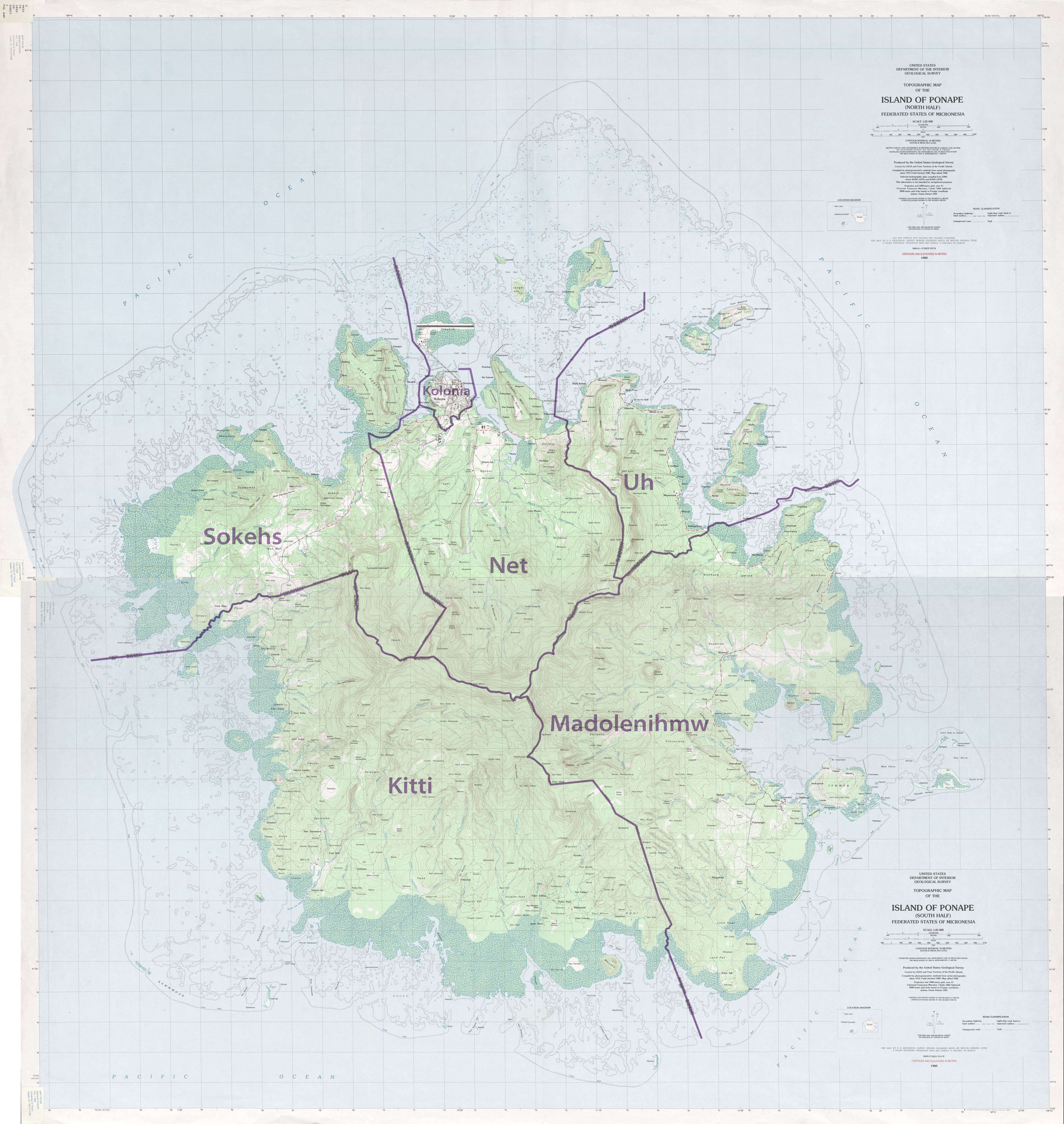
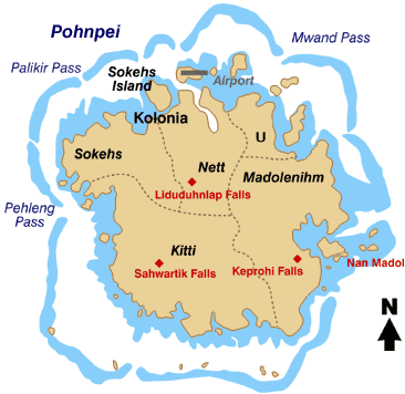
Pohnpei Map
Pohnpei "upon (''pohn'') a stone altar (''pei'')" (formerly known as Ponape or Ascension, Proto-Chuukic-Pohnpeic: ''*Fawo ni pei)'' is an island of the Senyavin Islands which are part of the larger Caroline Islands group. It belongs to Pohnpei State, one of the four states in the Federated States of Micronesia (FSM). Major population centers on Pohnpei include Palikir, the FSM's capital, and Kolonia, the capital of Pohnpei State. Pohnpei Island is the largest with an area of , and a highest point of , the most populous with 36,832 people, and the most developed single island in the FSM. Pohnpei is home to the megaliths and ruined city of Nan Madol, built of artificial islands off the island's eastern shore beginning in the 8th or 9th century. An important archaeological site, it was declared a national historic site in 1985. Pohnpei contains a wealth of biodiversity. It is one of the wettest places on Earth with annual recorded rainfall exceeding each year in certain mountai ... [...More Info...] [...Related Items...] OR: [Wikipedia] [Google] [Baidu] |
Pohnpei
Pohnpei "upon (''pohn'') a stone altar (''pei'')" (formerly known as Ponape or Ascension, Proto-Chuukic-Pohnpeic: ''*Fawo ni pei)'' is an island of the Senyavin Islands which are part of the larger Caroline Islands group. It belongs to Pohnpei State, one of the four states in the Federated States of Micronesia (FSM). Major population centers on Pohnpei include Palikir, the FSM's capital, and Kolonia, the capital of Pohnpei State. Pohnpei Island is the largest with an area of , and a highest point of , the most populous with 36,832 people, and the most developed single island in the FSM. Pohnpei is home to the megaliths and ruined city of Nan Madol, built of artificial islands off the island's eastern shore beginning in the 8th or 9th century. An important archaeological site, it was declared a national historic site in 1985. Pohnpei contains a wealth of biodiversity. It is one of the wettest places on Earth with annual recorded rainfall exceeding each year in certain mountai ... [...More Info...] [...Related Items...] OR: [Wikipedia] [Google] [Baidu] |
Nan Madol
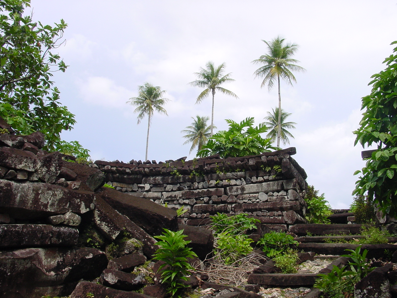
Nan Madol is an archaeological site adjacent to the eastern shore of the island of Pohnpei, now part of the Madolenihmw district of Pohnpei state in the Federated States of Micronesia in the western Pacific Ocean. Nan Madol was the capital of the Saudeleur dynasty until about 1628.Nan Madol, Madolenihmw, Pohnpei William Ayres, Department of Anthropology University Of Oregon, Accessed 26 September 2007 The city, constructed in a lagoon, consists of a series of small s linked by a network of canals. The site core with its stone walls encloses an area approximately 1.5 km long by 0.5 km wide and it contains 92 artificial islets—stone and c ... [...More Info...] [...Related Items...] OR: [Wikipedia] [Google] [Baidu] |
Caroline Islands
The Caroline Islands (or the Carolines) are a widely scattered archipelago of tiny islands in the western Pacific Ocean, to the north of New Guinea. Politically, they are divided between the Federated States of Micronesia (FSM) in the central and eastern parts of the group, and Palau at the extreme western end. Historically, this area was also called ''Nuevas Filipinas'' or New Philippines, because they were part of the Spanish East Indies and were governed from Manila in the Philippines. The Carolines are scattered across a distance of approximately 3,540 kilometers (2,200 miles), from the westernmost island, Tobi (island), Tobi, in Palau, to the easternmost island, Kosrae, a Administrative divisions of the Federated States of Micronesia, state of the FSM. Description The group consists of about 500 small coral islands, east of the Philippines, in the Pacific Ocean. The distance from Yap (one of the larger Caroline islands) to Manila is . Most of the islands are made up of ... [...More Info...] [...Related Items...] OR: [Wikipedia] [Google] [Baidu] |
Nan Madol 1
Nan or NAN may refer to: Places China * Nan County, Yiyang, Hunan, China * Nan Commandery, historical commandery in Hubei, China Thailand * Nan Province ** Nan, Thailand, the administrative capital of Nan Province * Nan River People Given name *Nan Cross (1928–2007), South African anti-apartheid and anti-conscription activist *Nan Hayworth (born 1959), former U.S. Representative from New York's 19th Congressional District *Nan Wood Honeyman, (1881–1970), first woman elected to the U.S. Congress from Oregon *Nan Hu, Chinese physician-scientist, molecular geneticist, and cancer epidemiologist *Nan Kempner (1930–2005), New York socialite *Nan Martin (1927–2010), American actress *Nan Grogan Orrock (born 1943), member of the Georgia House of Representatives and State Senator *Nan Phelps (1904–1990), American folk artist *Nan Rich (born 1942), member of the Florida Senate and former member of the House of Representatives *Nan C. Robertson (1926–2009), Pulitzer Prize-winn ... [...More Info...] [...Related Items...] OR: [Wikipedia] [Google] [Baidu] |
Tribal Chief
A tribal chief or chieftain is the leader of a tribal society or chiefdom. Tribe The concept of tribe is a broadly applied concept, based on tribal concepts of societies of western Afroeurasia. Tribal societies are sometimes categorized as an intermediate stage between the band society of the Paleolithic stage and civilization with centralized, super-regional government based in cities. Anthropologist Elman Service distinguishes two stages of tribal societies: simple societies organized by limited instances of social rank and prestige, and more stratified societies led by chieftains or tribal kings (chiefdoms). Stratified tribal societies led by tribal kings are thought to have flourished from the Neolithic stage into the Iron Age, albeit in competition with urban civilisations and empires beginning in the Bronze Age. In the case of tribal societies of indigenous peoples existing within larger colonial and post-colonial states, tribal chiefs may represent their tribe or ... [...More Info...] [...Related Items...] OR: [Wikipedia] [Google] [Baidu] |
Temwen Island
Temwen Island is a small island of 3 Square kilometers off the southeastern coast off the island of Pohnpei in the Federated States of Micronesia. Nan Madol It is best known as the location of the ruined city of Nan Madol Nan Madol is an archaeological site adjacent to the eastern shore of the island of Pohnpei, now part of the Madolenihmw district of Pohnpei state in the Federated States of Micronesia in the western Pacific Ocean. Nan Madol was the capital of t ..., the capital of the Saudeleur Dyanasty until 1628, which consisted of a series of artificially constructed islets off Temwen's southern coast. Along with the rest of Pohnpei, it forms a large inlet called Madolenihmw Bay. See also * Saudeleur Dynasty#Society Islands of Pohnpei {{Micronesia-geo-stub ... [...More Info...] [...Related Items...] OR: [Wikipedia] [Google] [Baidu] |
Madolenihmw
Madolenihmw is one of the administrative divisions of the Micronesian island of Pohnpei. It is located in the central east of the island, to the east of Mount Nahna Laud and south of Mount Kapwuriso. The coast of Madolenihmw includes a large bay which contains the island of Temwen, famous for its Nan Madol ruins. Climate Education Pohnpei State Department of Education operates public schools: * Madolenihmw High School * ESDM Elementary SchoolPohnpei Schools " Pohnpei State Department of Education. Retrieved on February 23, 2018. * Lukop Elementary School * Mand Elementary School * Pohnlangas Elementary School * Sapwalap Elementary School * Temwen Elementary School * Wapar Elementary School [...More Info...] [...Related Items...] OR: [Wikipedia] [Google] [Baidu] |
Pingelap
Pingelap is an atoll in the Pacific Ocean, part of Pohnpei State of the Federated States of Micronesia, consisting of three islands: Pingelap Island, Sukoru and Daekae, linked by a reef system and surrounding a central lagoon, although only Pingelap Island is inhabited. The entire system has a land area of 1.8 km² (455 acres) at high-tide, and is less than at its widest point. The atoll has its own language, Pingelapese language, Pingelapese, spoken by most of the atoll's 250 residents. History The first European observer of the islands was Captain Thomas Musgrave in the ship . Captain MacAskill in revisited them in 1809. Errors in measurement of their location resulted in the islands being separately named on charts in the 19th century as the Musgrave Islands and the MacAskill islands, within the Caroline archipelago. Historically, the ''Ouwa'' or the Paramount Chief or King of Pikelap which is a hereditary title that granted supreme rule of the land, ruled the island of ... [...More Info...] [...Related Items...] OR: [Wikipedia] [Google] [Baidu] |
Nomoi Islands
The Nomoi Islands, also known as the Mortlock Islands, are a group of three atolls in the state of Chuuk, Federated States of Micronesia. They are located about southeast of Chuuk Lagoon. Islands The Mortlock Islands are Ettal, Namoluk, Ta, Nama, Oneop, Losap, Moch, Picemwar, Satowan, Lukunor (Likinioch), and Kuttu (KuKuttu). Losap, Nama, and Namoluk are clustered to the northwest of the other islands and are also called the Upper Mortlock Islands or Eastern Islands. Satawan, the southern atoll, is the largest. Both Etal, the northern one, and Lukunor in the northeast are much smaller. They are located between from each other. History They were sighted by the Spanish expedition of Álvaro de Saavedra in 1528. Captain James Mortlock was sailing from Port Jackson to Whampoa in ''Young William'' when he rediscovered two sets of islands on 19 and 27 November 1795. Confusingly, both were later called Mortlock Islands.''The tale of the discovery of the two sets of “Mortl ... [...More Info...] [...Related Items...] OR: [Wikipedia] [Google] [Baidu] |
Losap
Losap is an atoll located in the Eastern Islands or Upper Mortlock Islands group in the outer islands region of the state of Chuuk in the Federated States of Micronesia. It is located to the SE of Chuuk. Losap is also the name of one of the four islands in the atoll. There are 3 villages in Losap: Pekias, Sotiw, and Lukan which also have groups in the villages. Linguistics The outer islands have different ways of saying Chuukese words; their accent is different from the Chuuk Lagoon Chuuk Lagoon, previously Truk Atoll, is an atoll in the central Pacific. It lies about northeast of New Guinea, and is part of Chuuk State within the Federated States of Micronesia (FSM). A protective reef, around, encloses a natural harbou ... people. Villages and groups References External links Directory of the islands of Micronesia Islands of Chuuk State Municipalities of Chuuk State Atolls of the Federated States of Micronesia {{Micronesia-geo-stub ... [...More Info...] [...Related Items...] OR: [Wikipedia] [Google] [Baidu] |
Kitti (municipality)
Kitti, also written as Kiti, is one of the twelve administrative divisions of the Micronesian state of Pohnpei. It is located in the southwest of the island of Pohnpei, to the south of Mount Nanlaud. Education Pohnpei State Department of Education operates public schools: * Nanpei Memorial High School a.k.a. Kitti High School * Enipein SchoolPohnpei Schools " Pohnpei State Department of Education. Retrieved on February 23, 2018. * Nanpei Memorial Elementary School * Pehleng Elementary School * Rohi Elementary School * Salapwuk Elementary School * Seinwar Elementary School * Wone Elementary School See also * |


