|
Inmarsat-C
Inmarsat-C is a two-way, packet data service operated by the telecommunications company Inmarsat which operates between mobile earth stations (MES) and land earth stations (LES). It became fully operational after a period of pre-operational trials in January 1991. The advantages of Inmarsat-C compared to Inmarsat-A are low cost, smaller and uses a smaller omni-directional antenna. The disadvantage is that voice communication is not possible with Inmarsat-C. The service is approved for use under the Global Maritime Distress and Safety System (GMDSS), meets the requirements for Ship Security Alert Systems (SSAS) defined by the International Maritime Organization (IMO) and is the most widely used service in fishing Vessel Monitoring Systems ( VMS). The service works with a store-and-forward method which enables interface with data network transfer including; e-mail; SMS; telex; remote monitoring; tracking (position reporting); chart and weather updates; maritime safety information ... [...More Info...] [...Related Items...] OR: [Wikipedia] [Google] [Baidu] |
Vessel Monitoring System
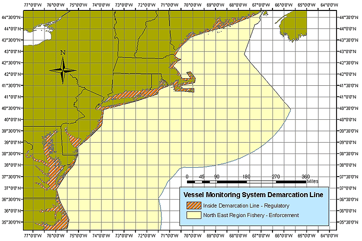
Vessel Monitoring Systems (VMS) is a general term to describe systems that are used in commercial fishing to allow environmental and fisheries regulatory organizations to track and monitor the activities of fishing vessels. They are a key part of monitoring control and surveillance (MCS) programs at national and international levels. VMS may be used to monitor vessels in the territorial waters of a country or a subdivision of a country, or in the Exclusive Economic Zones (EEZ) that extend 200 nautical miles (370.4 km) from the coasts of many countries. VMS systems are used to improve the management and sustainability of the marine environment, through ensuring proper fishing practices and the prevention of illegal fishing, and thus protect and enhance the livelihoods of fishermen. The exact functionality of a VMS system and the associated equipment varies with the requirements of the nation of the vessel's registry, and the regional or national water in which the vessel is ... [...More Info...] [...Related Items...] OR: [Wikipedia] [Google] [Baidu] |
GMDSS
The Global Maritime Distress and Safety System (GMDSS) is a worldwide system for automated emergency signal communication for ships at sea developed by the United Nations' International Maritime Organization (IMO) as part of the SOLAS Convention. It's a set of safety procedures, types of equipment, and communication protocols used for safety and rescue operations of the distressed ships, boats, and aircraft. It's supplemental to the International Convention on Maritime Search and Rescue (ICMSaR) adopted in 1979 and provides basis for the communication. GMDSS consists of several systems which are intended to perform the following functions: alerting (including position determination of the ship in distress) ships in the vicinity and ashore authorities, search and rescue coordination, locating (homing), maritime safety information broadcasts, general communications, and bridge-to-bridge communications. Specific radio carriage requirements depend upon the ship's area of operatio ... [...More Info...] [...Related Items...] OR: [Wikipedia] [Google] [Baidu] |
Maritime Safety Information
The Global Maritime Distress and Safety System (GMDSS) is a worldwide system for automated emergency signal communication for ships at sea developed by the United Nations' International Maritime Organization (IMO) as part of the SOLAS Convention. It's a set of safety procedures, types of equipment, and communication protocols used for safety and rescue operations of the distressed ships, boats, and aircraft. It's supplemental to the International Convention on Maritime Search and Rescue (ICMSaR) adopted in 1979 and provides basis for the communication. GMDSS consists of several systems which are intended to perform the following functions: alerting (including position determination of the ship in distress) ships in the vicinity and ashore authorities, search and rescue coordination, locating (homing), maritime safety information broadcasts, general communications, and bridge-to-bridge communications. Specific radio carriage requirements depend upon the ship's area of operation ... [...More Info...] [...Related Items...] OR: [Wikipedia] [Google] [Baidu] |
Station Radio Haut
Station may refer to: Agriculture * Station (Australian agriculture), a large Australian landholding used for livestock production * Station (New Zealand agriculture), a large New Zealand farm used for grazing by sheep and cattle ** Cattle station, a cattle-rearing station in Australia or New Zealand **Sheep station, a sheep-rearing station in Australia or New Zealand Communications * Radio communication station, a radio frequency communication station of any kind, including audio, TV, and non-broadcast uses ** Radio broadcasting station, an audio station intended for reception by the general public ** Amateur radio station, a station operating on frequencies allocated for ham or other non-commercial use ** Broadcast relay station ** Ground station (or Earth station), a terrestrial radio station for extraplanetary telecommunication with satellites or spacecraft ** Television station * Courier station, a relay station in a courier system ** Station of the ''cursus publicus'', a sta ... [...More Info...] [...Related Items...] OR: [Wikipedia] [Google] [Baidu] |
Omni-directional Antenna
In radio communication, an omnidirectional antenna is a class of antenna which radiates equal radio power in all directions perpendicular to an axis (azimuthal directions), with power varying with angle to the axis (elevation angle), declining to zero on the axis. When graphed in three dimensions ''(see graph)'' this radiation pattern is often described as ''doughnut-shaped''. Note that this is different from an isotropic antenna, which radiates equal power in ''all'' directions, having a ''spherical'' radiation pattern. Omnidirectional antennas oriented vertically are widely used for nondirectional antennas on the surface of the Earth because they radiate equally in all horizontal directions, while the power radiated drops off with elevation angle so little radio energy is aimed into the sky or down toward the earth and wasted. Omnidirectional antennas are widely used for radio broadcasting antennas, and in mobile devices that use radio such as cell phones, FM radios, walkie- ... [...More Info...] [...Related Items...] OR: [Wikipedia] [Google] [Baidu] |
Ship Security Alert System
The Ship Security Alert System (SSAS) is part of the ISPS code and is a system that contributes to the International Maritime Organization's (IMO)'s efforts to strengthen maritime security and suppress acts of terrorism and piracy against shipping. The system is an IMO regulated system. In case of attempted piracy or terrorism, the ship's SSAS beacon can be activated, and appropriate law-enforcement or military forces can be dispatched. An SSAS beacon operates with similar principles to the aircraft transponder emergency code 7700. See also *Cospas-Sarsat *GMDSS *International Convention for the Safety of Life at Sea *International Maritime Organization The International Maritime Organization (IMO, French: ''Organisation maritime internationale'') is a specialised agency of the United Nations responsible for regulating shipping. The IMO was established following agreement at a UN conference ... * Long-Range Identification and Tracking (LRIT) References External link ... [...More Info...] [...Related Items...] OR: [Wikipedia] [Google] [Baidu] |
International Maritime Organization
The International Maritime Organization (IMO, French: ''Organisation maritime internationale'') is a specialised agency of the United Nations responsible for regulating shipping. The IMO was established following agreement at a UN conference held in Geneva in 1948 and the IMO came into existence ten years later, meeting for the first time in 1959. Headquartered in London, United Kingdom, IMO currently has 175 Member States and three Associate Members. The IMO's primary purpose is to develop and maintain a comprehensive regulatory framework for shipping and its remit today includes maritime safety, environmental concerns, legal matters, technical co-operation, maritime security and the efficiency of shipping. IMO is governed by an assembly of members which meets every two years. Its finance and organization is administered by a council of 40 members elected from the assembly. The work of IMO is conducted through five committees and these are supported by technical subcommitte ... [...More Info...] [...Related Items...] OR: [Wikipedia] [Google] [Baidu] |
National Transportation Safety Board
The National Transportation Safety Board (NTSB) is an independent U.S. government investigative agency responsible for civil transportation accident investigation. In this role, the NTSB investigates and reports on aviation accidents and incidents, certain types of highway crashes, ship and marine accidents, pipeline incidents, bridge failures, and railroad accidents. The NTSB is also in charge of investigating cases of hazardous materials releases that occur during transportation. The agency is based in Washington, D.C. It has four regional offices, located in Anchorage, Alaska; Denver, Colorado; Ashburn, Virginia; and Seattle, Washington. The agency also operates a national training center at its Ashburn facility. History The origin of the NTSB was in the Air Commerce Act of 1926, which assigned the United States Department of Commerce responsibility for investigating domestic aviation accidents. Before the NTSB, the Federal Aviation Administration's (FAA; at the t ... [...More Info...] [...Related Items...] OR: [Wikipedia] [Google] [Baidu] |
Data Reporting
Data reporting is the process of collecting and submitting data which gives rise to accurate analyses of the facts on the ground; inaccurate data reporting can lead to vastly uninformed decision-making based on erroneous evidence. Different from data analysis that transforms data and information into insights, data reporting is the previous step that translates raw data into information. When data is not reported, the problem is known as underreporting; the opposite problem leads to false positives. Data reporting can be an incredibly difficult endeavor. Census A census is the procedure of systematically acquiring, recording and calculating information about the members of a given population. This term is used mostly in connection with national population and housing censuses; other common censuses incl ... bureaus may hire even hundreds of thousands of workers to achieve the task of counting all of the residents of a country. Teachers use data from student assessments to determi ... [...More Info...] [...Related Items...] OR: [Wikipedia] [Google] [Baidu] |
BBC Box
The Box or BBC Box ( BIC code: NYKU8210506) was a single ISO intermodal container that was tracked by BBC News between September 2008 and April 2009, as part of a project to study international trade and globalisation. The Box was fitted with tracking equipment and painted in a special one-off livery. The tracking project was launched on 8 September 2008. The project tracked a standard shipping container as it was transported by its owner, Nippon Yusen Kaisha (NYK) shipping line using intermodal freight transport with various cargoes. An on-board GPS unit tracked the Box's location and this was used to update a map showing the current location and previous route. If the container's GPS or communications signal was obstructed (such as having been stacked too far inside the ship's hold), the ship's own GPS location was used to manually update a map. The tracking unit suffered technical problems during December 2008. The Box was painted in a special BBC paint scheme and was named ... [...More Info...] [...Related Items...] OR: [Wikipedia] [Google] [Baidu] |
Intermodal Container
An intermodal container, often called a shipping container, is a large standardized shipping container, designed and built for intermodal freight transport, meaning these containers can be used across different Mode of transport, modes of transport – from container ship, ship to Rail transport, rail to Semi-trailer truck, truck – without unloading and reloading their cargo. Intermodal containers are primarily used to store and transport materials and products efficiently and securely in the global containerization, containerized intermodal freight transport system, but smaller numbers are in regional use as well. These containers are known under a number of names. Based on size alone, up to 95% of intermodal containers comply with ISO standards, and can officially be called ISO containers. Many other names are simply: container, cargo or freight container, shipping, sea or ocean container, container van or sea van, sea can or C can, or MILVAN, SEAVAN, or RO/RO. The also used ... [...More Info...] [...Related Items...] OR: [Wikipedia] [Google] [Baidu] |


