|
Inkerman
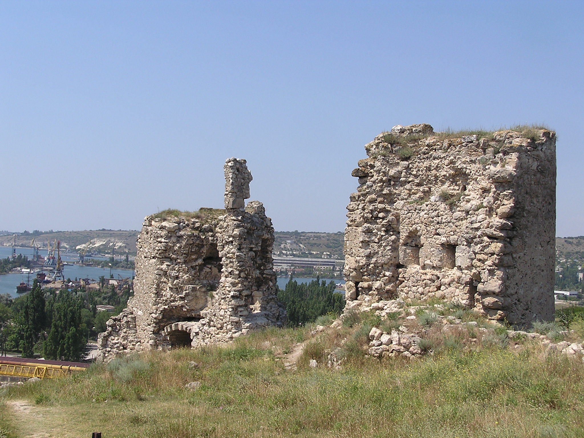
Inkerman ( uk, Інкерман, russian: Инкерман, crh, İnkerman) is a city in the Crimean peninsula. It is ''de facto'' within the federal city of Sevastopol within the Russian Federation, but ''de jure'' within Ukraine. It lies 5 kilometres east of Sevastopol, at the mouth of the Chernaya River which flows into Sevastopol Inlet (also called the North Inlet). Administratively, Inkerman is subordinate to the municipality of Sevastopol which does not constitute part of the Autonomous Republic of Crimea. Population: The name ''Inkerman'' is said to mean "cave fortress" in Turkish. Compare: Turkish ''in'' (cave, burrow); Turkish ''kermen'' (fortress). During the Soviet era the area was known between 1976 and 1991 as ''Bilokamiansk'' ( uk, Білокам'янськ) or ''Belokamensk'' (russian: Белокаменск), which literally means "White Stone City", in reference to the soft white stone quarried in the area and commonly used for construction. In 1991 the ... [...More Info...] [...Related Items...] OR: [Wikipedia] [Google] [Baidu] |
Battle Of Inkerman
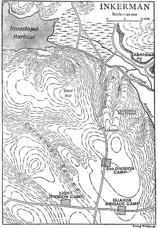
The Battle of Inkerman was fought during the Crimean War on 5 November 1854 between the allied armies of United Kingdom of Great Britain and Ireland, Britain and Second French Empire, France against the Imperial Russian Empire, Russian Army. The battle broke the will of the Russian Army to defeat the allies in the field, and was followed by the Siege of Sevastopol (1854–1855), siege of Sevastopol. The role of troops fighting mostly on their own initiative due to the foggy conditions during the battle has earned the engagement the name "The Soldier's Battle." Prelude to the battle The allied armies of Britain, France, Sardinia, and the Ottoman Empire had landed on the west coast of Crimea on 14 September 1854, intending to capture the Russian naval base at Sevastopol. The allied armies fought off and defeated the Russian Army at the Battle of Alma, forcing them to retreat in some confusion toward the River Kacha. While the allies could have taken this opportunity to attack Se ... [...More Info...] [...Related Items...] OR: [Wikipedia] [Google] [Baidu] |
Inkerman Cave Monastery
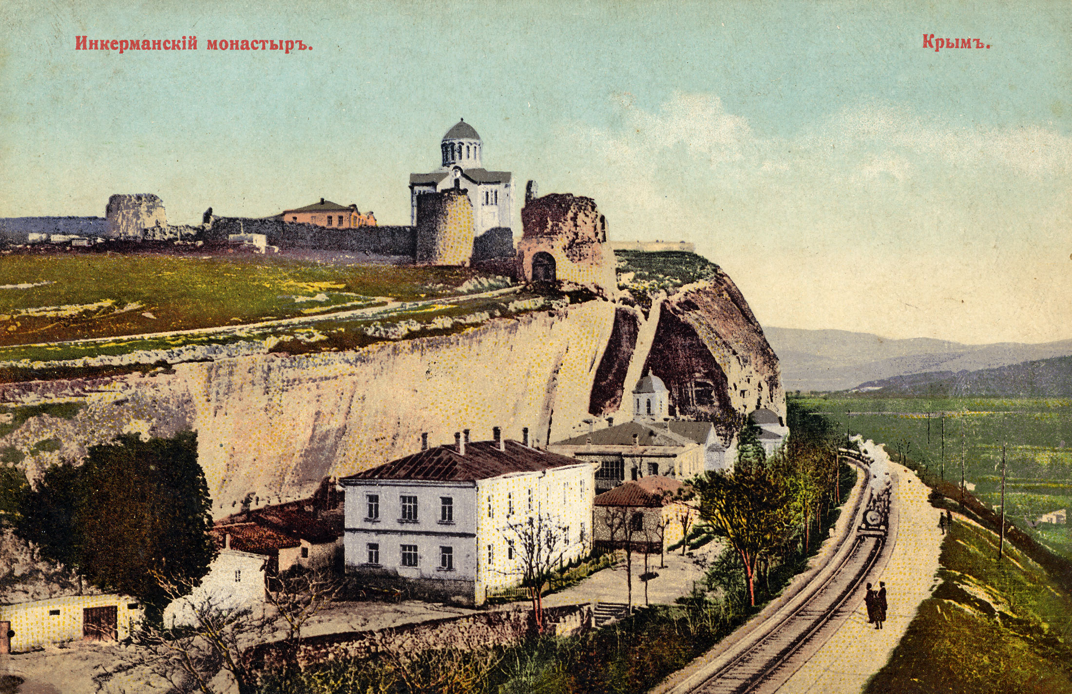
, native_name_lang = , logo = , logo_size = , logo_caption = , image = Inkerman Cave Monastery chapel.jpg , image_size = , image_caption = One of the Inkerman Cave Monastery chapels in 2012. , map_type = Sevastopol#Ukraine Crimea#Ukraine , pushpin_relief = 1 , pushpin_label = Inkerman Cave Monastery , image_map = , map_caption = , location = Inkerman, Ukraine , address = , location_city = , location_country = , coordinates = , former_names = , alternate_names = , etymology = , status = , cancelled = , topped_out = , building_type = , architectural_style = , material = , classification = , altitude = , namesake = , groundbreaking_date = , start_date = 1850 , stop_date ... [...More Info...] [...Related Items...] OR: [Wikipedia] [Google] [Baidu] |
Grenadier Guards
"Shamed be whoever thinks ill of it." , colors = , colors_label = , march = Slow: " Scipio" , mascot = , equipment = , equipment_label = , battles = Oudenarde WaterlooAlmaInkermanSevastopol OmdurmanYpresBattle of the BulgeCyprus Emergency , anniversaries = , decorations = , battle_honours = , battle_honours_label = , disbanded = , flying_hours = , website = , commander1 = The King , commander1_label = Colonel-in-Chief , commander2 = The Queen Consort , commander2_label = Colonel of the Regiment , commander3 = , commander3_label = , commander4 = , commander4_label ... [...More Info...] [...Related Items...] OR: [Wikipedia] [Google] [Baidu] |
Crimean War
The Crimean War, , was fought from October 1853 to February 1856 between Russia and an ultimately victorious alliance of the Ottoman Empire, France, the United Kingdom and Piedmont-Sardinia. Geopolitical causes of the war included the decline of the Ottoman Empire, the expansion of the Russian Empire in the preceding Russo-Turkish Wars, and the British and French preference to preserve the Ottoman Empire to maintain the balance of power in the Concert of Europe. The flashpoint was a disagreement over the rights of Christian minorities in Palestine, then part of the Ottoman Empire, with the French promoting the rights of Roman Catholics, and Russia promoting those of the Eastern Orthodox Church. The churches worked out their differences with the Ottomans and came to an agreement, but both the French Emperor Napoleon III and the Russian Tsar Nicholas I refused to back down. Nicholas issued an ultimatum that demanded the Orthodox subjects of the Ottoman Empire be placed ... [...More Info...] [...Related Items...] OR: [Wikipedia] [Google] [Baidu] |
Sevastopol
Sevastopol (; uk, Севасто́поль, Sevastópolʹ, ; gkm, Σεβαστούπολις, Sevastoúpolis, ; crh, Акъя́р, Aqyár, ), sometimes written Sebastopol, is the largest city in Crimea, and a major port on the Black Sea. Due to its strategic location and the navigability of the city's harbours, Sevastopol has been an important port and naval base throughout its history. Since the city's founding in 1783 it has been a major base for Russia's Black Sea Fleet, and it was previously a closed city during the Cold War. The total administrative area is and includes a significant amount of rural land. The urban population, largely concentrated around Sevastopol Bay, is 479,394, and the total population is 547,820. Sevastopol, along with the rest of Crimea, is internationally recognised as part of Ukraine, and under the Ukrainian legal framework, it is administratively one of two cities with special status (the other being Kyiv). However, it has been occupied b ... [...More Info...] [...Related Items...] OR: [Wikipedia] [Google] [Baidu] |
Crimea
Crimea, crh, Къырым, Qırım, grc, Κιμμερία / Ταυρική, translit=Kimmería / Taurikḗ ( ) is a peninsula in Ukraine, on the northern coast of the Black Sea, that has been occupied by Russia since 2014. It has a population of 2.4 million. The peninsula is almost entirely surrounded by the Black Sea and the smaller Sea of Azov. The Isthmus of Perekop connects the peninsula to Kherson Oblast in mainland Ukraine. To the east, the Crimean Bridge, constructed in 2018, spans the Strait of Kerch, linking the peninsula with Krasnodar Krai in Russia. The Arabat Spit, located to the northeast, is a narrow strip of land that separates the Sivash lagoons from the Sea of Azov. Across the Black Sea to the west lies Romania and to the south is Turkey. Crimea (called the Tauric Peninsula until the early modern period) has historically been at the boundary between the classical world and the steppe. Greeks colonized its southern fringe and were absorbed by the Ro ... [...More Info...] [...Related Items...] OR: [Wikipedia] [Google] [Baidu] |
Chernaya River (Ukraine)
The Chorna, Chyornaya or Chorhun (, ''Chorna'', , ''Chyornaya'', ), which translates from the Ukrainian and Russian as "Black River", is a small river in southern Crimea. It is 34.5 km long. The Chorna River begins in the Baydar Valley northeast of the small town of Rodnikivs'ke (44° 28' N 33° 51' EG), just west of which it flows into a reservoir. From there it continues in a westerly direction to the town of Inkerman (Belokamensk) where it enters the Bay of Sevastopol, on the southwest coast of the Crimean peninsula. Inkerman was a key location during the Crimean War The Crimean War, , was fought from October 1853 to February 1856 between Russia and an ultimately victorious alliance of the Ottoman Empire, France, the United Kingdom and Piedmont-Sardinia. Geopolitical causes of the war included the ... of 1853–1856 and the Chorna lends its name to the Battle of Chornaya River of 1855. {{Rivers of Ukraine Rivers of Crimea ... [...More Info...] [...Related Items...] OR: [Wikipedia] [Google] [Baidu] |
Principality Of Theodoro
The Principality of Theodoro ( el, Αὐθεντία πόλεως Θεοδωροῦς καὶ παραθαλασσίας), also known as Gothia ( el, Γοτθία) or the Principality of Theodoro-Mangup, was a Greek principality in the southern part of Crimea, specifically on the foothills of the Crimean Mountains. It represented one of the final rump states of the Eastern Roman Empire and the last territorial vestige of the Crimean Goths until its conquest by the Ottoman Empire by the Ottoman Albanian Gedik Ahmed Pasha in 1475. Its capital was Doros, also sometimes called Theodoro and now known as Mangup. The state was closely allied with the Empire of Trebizond. History In the late 12th century, the Crimean peninsula had seceded from the Byzantine Empire, but soon after the sack of Constantinople in 1204 parts of it were included in the Trapezuntine '' Gazarian Perateia''. This dependence was never very strong and was eventually replaced by the invading Mongols, who in 1238 po ... [...More Info...] [...Related Items...] OR: [Wikipedia] [Google] [Baidu] |
List Of Renamed Cities In Ukraine
The following is a list of cities in Ukraine that underwent a name change in the past. For the most updated list of changes, visit List of Ukrainian toponyms that were changed as part of decommunization in 2016 Chernihiv Oblast * Snovsk → Shchors (1935) → Snovsk (2016) Crimea * Aluston → Lusta → Aluşta → Alushta (1784) * Ermeni Bazar → Armianskyi Bazar (1736) → Armiansk (1921) * Karasubazar → Bilohirsk (1944) * Aqmeçit → Chornomorske (1944) * Canköy → Dzhankoi (1784) * Kerkinitis → Kezlev (7th century) → Gözleve → Yevpatoria (1784) * Theodosia → Ardabda → Kafas → Caffa → Kefe (1475) → Feodosia (1784) * Sarabuz → Hvardiiske (1944) * Inkerman → Belokamensk (1976) → Inkerman (1991) * Panticapaeum → Bosporus → Korchev → Vosporo/Cerchio → Kerch * İslâm Terek → Kirovske (1944) * Kurman-Kumelĉi → Krasnohvardiyske (1944) * Qızıltaş → Krasnokamianka (1945) * Aşağı Otuz → Prymorie (1945) → Kurortne (1978) * Albat ... [...More Info...] [...Related Items...] OR: [Wikipedia] [Google] [Baidu] |
Sevastopol Bay
Sevastopol Bay ( uk, Севастопольська бухта; russian: Севастопольская бухта) is a city harbor that includes a series of smaller bays carved out its shores. The bay of Sevastopol splits the city of Sevastopol into the Southern side and the Northern side. It serves as an extension of the Chornaya River and stretches for which is the longest of them all. The bay of Sevastopol stretches from the open sea eastward to the Inkerman Cave Monastery at the end, narrowing down and finishing at the mouth of the Chorna River. The bay forms the seaward approach to the city. Covering a large expanse of water, the harbor serves as a comfortable anchorage for a fleet. From the beginning of the 20th century it housed cruisers and ironclads. The number of piers along the shores of the harbor far exceeds the number of bays. The bay serves as a home to a commercial port as well as a naval base. Just outside of Sevastopol Bay is located a fishing port. See a ... [...More Info...] [...Related Items...] OR: [Wikipedia] [Google] [Baidu] |
Military Of Ukraine
A military, also known collectively as armed forces, is a heavily armed, highly organized force primarily intended for warfare. It is typically authorized and maintained by a sovereign state, with its members identifiable by their distinct military uniform. It may consist of one or more military branches such as an army, navy, air force, space force, marines, or coast guard. The main task of the military is usually defined as defence of the state and its interests against external armed threats. In broad usage, the terms ''armed forces'' and ''military'' are often treated as synonymous, although in technical usage a distinction is sometimes made in which a country's armed forces may include both its military and other paramilitary forces. There are various forms of irregular military forces, not belonging to a recognized state; though they share many attributes with regular military forces, they are less often referred to as simply ''military''. A nation's military may f ... [...More Info...] [...Related Items...] OR: [Wikipedia] [Google] [Baidu] |
Black Sea Fleet
Chernomorskiy flot , image = Great emblem of the Black Sea fleet.svg , image_size = 150px , caption = Great emblem of the Black Sea fleet , dates = May 13, 1783 – present , country = , allegiance = , branch = Russian Navy , type = , role = Naval warfare; Amphibious military operations;Combat patrols in the Black Sea;Naval presence/diplomacy missions in the Mediterranean and elsewhere , size = 25,000 personnel (including marines) c. 40 surface warships (surface combatants, amphibious, mine warfare) plus support and auxiliaries 7 submarines (2 of which are in the Mediterranean as of March 2022) , command_structure = Russian Armed Forces , garrison = Sevastopol ( HQ), Feodosia (Crimea) Novorossiysk, Tuapse, T ... [...More Info...] [...Related Items...] OR: [Wikipedia] [Google] [Baidu] |


