|
Inkerman, Paisley
Inkerman was a small hamlet set up in 1858 in the Abbey Parish of Paisley to house ironstone miners. Later employment came from ancillary operations, including shale coal and oilworks. Inkerman has a total of seven pits. The hamlet was named after a recent (1854) British military victory, the Battle of Inkerman, in the Crimean War. Similarly, the nearby Balaklava settlement housed miners for the ''Clippens'' mines (now in Linwood) from 1855. The hamlet of ''Redan'' was named to commemorate the storming of the fortifications - Redan - in the Siege of Sevastopol (1854–1855). The miners from these settlements had their own rivalries. On Saturday 12 July 1859 the miners from ''The Redan'' in Linwood, on one side of the Black Cart Water, and their rivals from ''Inkerman'', on the other side, met in the (grandly called) ''Battle of Linwood Bridge''. (The bridge is still there at the end of ''Bridge Street, Linwood''). The men were armed with various weapons such as mining tools, swo ... [...More Info...] [...Related Items...] OR: [Wikipedia] [Google] [Baidu] |
Abbey Parish
Abbey, or sometimes Abbey Paisley, is a civil parish in Renfrewshire, Scotland traditionally centred on the towns of Paisley and Johnstone and including the smaller settlements of Elderslie, Inkerman, Hurlet, Nitshill, the Dovecothall area of Barrhead, and the hamlets of Thorn and Quarrelton, now subsumed into Johnstone. The parish owes its name to Paisley Abbey, the central religious site in the county and the parish church. The town of Paisley fell entirely within the Abbey Parish until 1736, when three parishes were formed within the burgh: High, Middle and Laigh (Low). A small portion of the Abbey Parish remained within the burgh after this time. For religious purposes, the towns of Johnstone and Elderslie formed their own ''quoad sacra'' parishes. Community Councils Following the decline in the importance of parishes in Scotland for local government Local government is a generic term for the lowest tiers of public administration within a particular sovereign stat ... [...More Info...] [...Related Items...] OR: [Wikipedia] [Google] [Baidu] |
River Cart
The River Cart ( sco, River Cairt) is a tributary of the River Clyde, Scotland, which it joins from the west roughly midway between the towns of Erskine and Renfrew and opposite the town of Clydebank. The River Cart itself is very short, being formed from the confluence of the Black Cart Water (from the west) and the White Cart Water (from the south east) and is only long. The River Cart and its tributary the White Cart Water were navigable as far as the Seedhill Craigs at Paisley; and, as with the River Clyde, various improvements were made to this river navigation. In 1840 the Forth and Cart Canal was opened, linking the Forth and Clyde Canal, at Whitecrook near Clydebank, to the River Clyde, opposite the mouth of the River Cart. The aim was to provide a direct link between Paisley, Port Dundas, Edinburgh, and the Firth of Forth.Lindsay, Jean (1968). ''The Canals of Scotland''. Newton Abbott: David & Charles Black Cart Water The Black Cart Water ( sco, Black Cairt Watt ... [...More Info...] [...Related Items...] OR: [Wikipedia] [Google] [Baidu] |
Areas In Paisley, Renfrewshire
Area is the quantity that expresses the extent of a region on the plane or on a curved surface. The area of a plane region or ''plane area'' refers to the area of a shape or planar lamina, while '' surface area'' refers to the area of an open surface or the boundary of a three-dimensional object. Area can be understood as the amount of material with a given thickness that would be necessary to fashion a model of the shape, or the amount of paint necessary to cover the surface with a single coat. It is the two-dimensional analogue of the length of a curve (a one-dimensional concept) or the volume of a solid (a three-dimensional concept). The area of a shape can be measured by comparing the shape to squares of a fixed size. In the International System of Units (SI), the standard unit of area is the square metre (written as m2), which is the area of a square whose sides are one metre long. A shape with an area of three square metres would have the same area as three such squa ... [...More Info...] [...Related Items...] OR: [Wikipedia] [Google] [Baidu] |
Ordnance Survey
, nativename_a = , nativename_r = , logo = Ordnance Survey 2015 Logo.svg , logo_width = 240px , logo_caption = , seal = , seal_width = , seal_caption = , picture = , picture_width = , picture_caption = , formed = , preceding1 = , dissolved = , superseding = , jurisdiction = Great BritainThe Ordnance Survey deals only with maps of Great Britain, and, to an extent, the Isle of Man, but not Northern Ireland, which has its own, separate government agency, the Ordnance Survey of Northern Ireland. , headquarters = Southampton, England, UK , region_code = GB , coordinates = , employees = 1,244 , budget = , minister1_name = , minister1_pfo = , chief1_name = Steve Blair , chief1_position = CEO , agency_type = , parent_agency = , child1_agency = , keydocument1 = , website = , footnotes = , map = , map_width = , map_caption = Ordnance Survey (OS) is the national mapping agency for Great Britain. The agency's name indicates its original military purpose (se ... [...More Info...] [...Related Items...] OR: [Wikipedia] [Google] [Baidu] |
Shale
Shale is a fine-grained, clastic sedimentary rock formed from mud that is a mix of flakes of clay minerals (hydrous aluminium phyllosilicates, e.g. kaolin, Al2 Si2 O5( OH)4) and tiny fragments (silt-sized particles) of other minerals, especially quartz and calcite.Blatt, Harvey and Robert J. Tracy (1996) ''Petrology: Igneous, Sedimentary and Metamorphic'', 2nd ed., Freeman, pp. 281–292 Shale is characterized by its tendency to split into thin layers ( laminae) less than one centimeter in thickness. This property is called '' fissility''. Shale is the most common sedimentary rock. The term ''shale'' is sometimes applied more broadly, as essentially a synonym for mudrock, rather than in the more narrow sense of clay-rich fissile mudrock. Texture Shale typically exhibits varying degrees of fissility. Because of the parallel orientation of clay mineral flakes in shale, it breaks into thin layers, often splintery and usually parallel to the otherwise indistinguishable beddin ... [...More Info...] [...Related Items...] OR: [Wikipedia] [Google] [Baidu] |
Truck Acts
Truck Acts is the name given to legislation that outlaws truck systems, which are also known as "company store" systems, commonly leading to debt bondage. In England and Wales such laws date back to the 15th century. History The modern successor of the Truck Acts is found in the Employment Rights Act 1996 sections 13–27. This replaced and updated the Wages Act 1986 which had itself repealed the Truck Acts. A case called '' Bristow v City Petroleum'' was the last case to be decided under the old legislation and in it, Lord Ackner in the House of Lords gave a short history of the previous regime. British legislation In Great Britain and (after 1801) the United Kingdom, a series of Acts of Parliament have been enacted to make truck systems unlawful: *The Truck Act 1725 *The Truck Act 1831 (1 & 2 Will 4 c 37) *The Truck Amendment Act 1887 (50 & 51 Vict c 46) *The Truck Act 1896 (59 & 60 Vict c 44) *The Truck Act 1940 (3 & 4 Geo 6 c 38) The Truck Acts 1831 to 1896 means th ... [...More Info...] [...Related Items...] OR: [Wikipedia] [Google] [Baidu] |
Inkerman Bowling Club
Inkerman ( uk, Інкерман, russian: Инкерман, crh, İnkerman) is a city in the Crimean peninsula. It is ''de facto'' within the federal city of Sevastopol within the Russian Federation, but ''de jure'' within Ukraine. It lies 5 kilometres east of Sevastopol, at the mouth of the Chernaya River which flows into Sevastopol Inlet (also called the North Inlet). Administratively, Inkerman is subordinate to the municipality of Sevastopol which does not constitute part of the Autonomous Republic of Crimea. Population: The name ''Inkerman'' is said to mean "cave fortress" in Turkish. Compare: Turkish ''in'' (cave, burrow); Turkish ''kermen'' (fortress). During the Soviet era the area was known between 1976 and 1991 as ''Bilokamiansk'' ( uk, Білокам'янськ) or ''Belokamensk'' (russian: Белокаменск), which literally means "White Stone City", in reference to the soft white stone quarried in the area and commonly used for construction. In 1991 th ... [...More Info...] [...Related Items...] OR: [Wikipedia] [Google] [Baidu] |
Church Of Scotland
The Church of Scotland ( sco, The Kirk o Scotland; gd, Eaglais na h-Alba) is the national church in Scotland. The Church of Scotland was principally shaped by John Knox, in the Scottish Reformation, Reformation of 1560, when it split from the Catholic Church and established itself as a church in the reformed tradition. The church is Calvinist Presbyterian, having no head of faith or leadership group and believing that God invited the church's adherents to worship Jesus. The annual meeting of its general assembly is chaired by the Moderator of the General Assembly of the Church of Scotland. The Church of Scotland celebrates two sacraments, Baptism and the Lord's Supper in Reformed theology, Lord's Supper, as well as five other Rite (Christianity), rites, such as Confirmation and Christian views on marriage, Matrimony. The church adheres to the Bible and the Westminster Confession of Faith, and is a member of the World Communion of Reformed Churches. History Presbyterian tra ... [...More Info...] [...Related Items...] OR: [Wikipedia] [Google] [Baidu] |
Siege Of Sevastopol (1854–1855)
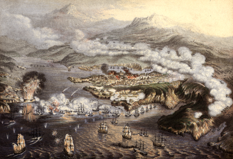
The siege of Sevastopol (at the time called in English the siege of Sebastopol) lasted from October 1854 until September 1855, during the Crimean War. The allies ( French, Sardinian, Ottoman, and British) landed at Eupatoria on 14 September 1854, intending to make a triumphal march to Sevastopol, the capital of the Crimea, with 50,000 men. Major battles along the way were Alma (September 1854), Balaklava (October 1854), Inkerman (November 1854), Tchernaya (August 1855), Redan (September 1855), and, finally, Malakoff (September 1855). During the siege, the allied navy undertook six bombardments of the capital, on 17 October 1854; and on 9 April, 6 June, 17 June, 17 August, and 5 September 1855. The Siege of Sevastopol is one of the last classic sieges in history. The city of Sevastopol was the home of the Tsar's Black Sea Fleet, which threatened the Mediterranean. The Russian field army withdrew before the allies could encircle it. The siege was the culminating struggle fo ... [...More Info...] [...Related Items...] OR: [Wikipedia] [Google] [Baidu] |
Paisley, Renfrewshire
Paisley ( ; sco, Paisley, gd, Pàislig ) is a large town situated in the west central Lowlands of Scotland. Located north of the Gleniffer Braes, the town borders the city of Glasgow to the east, and straddles the banks of the White Cart Water, a tributary of the River Clyde. Paisley serves as the administrative centre for the Renfrewshire council area, and is the largest town in the historic county of the same name. It is often cited as "Scotland's largest town" and is the fifth largest settlement in the country, although it does not have city status. The town became prominent in the 12th century, with the establishment of Paisley Abbey, an important religious hub which formerly had control over other local churches. By the 19th century, Paisley was a centre of the weaving industry, giving its name to the Paisley shawl and the Paisley pattern. The town's associations with political radicalism were highlighted by its involvement in the Radical War of 1820, with striking ... [...More Info...] [...Related Items...] OR: [Wikipedia] [Google] [Baidu] |
Redan
Redan (a French word for "projection", "salient") is a feature of fortifications. It is a work in a V-shaped salient angle towards an expected attack. It can be made from earthworks or other material. The redan developed from the lunette, originally a half-moon-shaped outwork; with shorter flanks it became a redan. History Redans were a common feature in the coastal batteries built in Malta between 1715 and the end of the 18th century. Surviving batteries with redans include Mistra Battery and Saint Anthony's Battery. The Russians used redans on their left at the Battle of Borodino against Napoleon. A small redan whose faces make an obtuse angle with a vertex toward the enemy is called a ''flèche'' (arrow in French). The ''Bagration flèches'' were three redans backwards in echelon. The Shevardino Redoubt (another redan) was erected as an early warning post a mile in front of the Bagration flèches. The "Redan hole" in golf A ''Redan hole'' or ''Redan'' is an aspe ... [...More Info...] [...Related Items...] OR: [Wikipedia] [Google] [Baidu] |


