|
Inishowen East
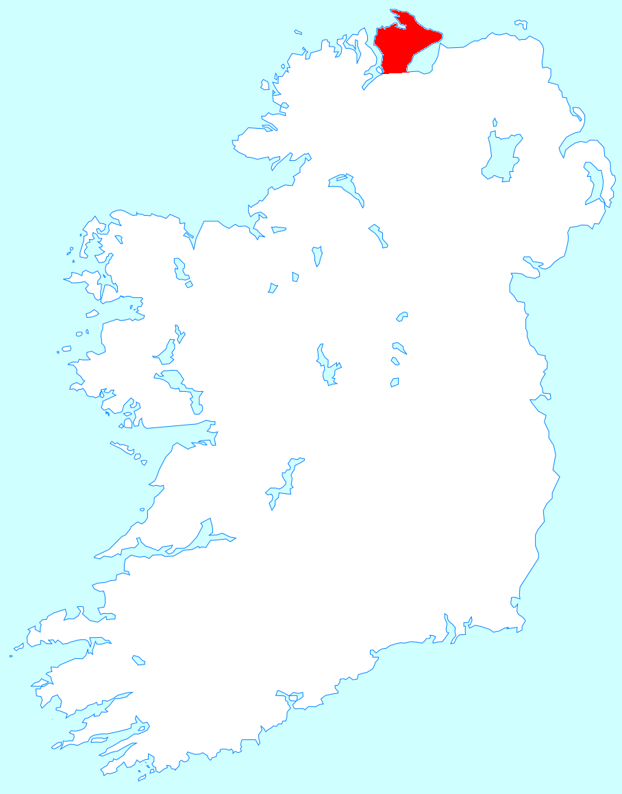
Inishowen East (), also called East Inishowen or Innishowen East, is a barony in County Donegal, Republic of Ireland. Baronies were mainly cadastral rather than administrative units. They acquired modest local taxation and spending functions in the 19th century before being superseded by the Local Government (Ireland) Act 1898. Etymology Inishowen East takes its name from Inishowen, in Irish ''Inis Eoghain'', "Eoghan's island eninsula, referring to Eógan mac Néill, a semi-legendary king of the 5th century AD and ancestor of the Cenél nEógain dynasty. Geography Inishowen East is located in the northeast of the Inishowen Peninsula. History Inishowen East was once part of the ancient kingdom of Moy Ith. Inishowen was originally a single barony but was divided in the 1830s into West and East. List of settlements Below is a list of settlements in Inishowen East: * Ballyliffin *Carndonagh *Clonmany *Culdaff Culdaff () is a village on the Inishowen peninsula of County D ... [...More Info...] [...Related Items...] OR: [Wikipedia] [Google] [Baidu] |
Irish Language
Irish ( Standard Irish: ), also known as Gaelic, is a Goidelic language of the Insular Celtic branch of the Celtic language family, which is a part of the Indo-European language family. Irish is indigenous to the island of Ireland and was the population's first language until the 19th century, when English gradually became dominant, particularly in the last decades of the century. Irish is still spoken as a first language in a small number of areas of certain counties such as Cork, Donegal, Galway, and Kerry, as well as smaller areas of counties Mayo, Meath, and Waterford. It is also spoken by a larger group of habitual but non-traditional speakers, mostly in urban areas where the majority are second-language speakers. Daily users in Ireland outside the education system number around 73,000 (1.5%), and the total number of persons (aged 3 and over) who claimed they could speak Irish in April 2016 was 1,761,420, representing 39.8% of respondents. For most of recorded ... [...More Info...] [...Related Items...] OR: [Wikipedia] [Google] [Baidu] |
Eógan Mac Néill
Eógan mac Néill ( modern orthography: Eoghan mac Néill) (reportedly died 465) was a son of Niall Noígiallach and the eponymous ancestor of the Cenél nEógain (kindred of Eoghan) branch of the Northern Uí Néill. The Cenél Eoghan would found the over-kingdom of Ailech and later Tír Eoghain, which would span the greater part of Ulster. His burial place is said to be in the Inishowen Peninsula in County Donegal, Ireland which was named after him. The historical accuracy or existence of Eógan and his father however are unknown. Overview Eogan mac Néill is claimed as having been a close friend of Saint Patrick and received Patrick's blessing. With his brother, the High King Lóegaire mac Néill (d. 462), he was one of the judges in a dispute over the succession to Amalgaid (d.440), king of Connacht, among his sons competing to rule their territory of Tir Amalgaidh in northwest Connacht. Eoghan is reputedly buried at St. Patrick's Church in Iskaheen, Inishowen, Donega ... [...More Info...] [...Related Items...] OR: [Wikipedia] [Google] [Baidu] |
Moville
Moville (; ) is a coastal town located on the Inishowen Peninsula of County Donegal, Ireland, close to the northern tip of the island of Ireland. It is the first coastal town of the Wild Atlantic Way when starting on the northern end. Location The town is located on the western shore of Lough Foyle, approximately from Derry, which lies across the border in Northern Ireland. Features include Moville Green, a pier, a large seaside park in the Victorian style which features bandstands, walking trails, playgrounds, a coastal footpath and views east across the waters of the lough to Northern Ireland. Moville is close to several beaches, and receives visitors and daytrippers in the summer months. Moville Community College is located to the south of the town centre, in the townland of Carrownaff. History In the second half of the 19th century, Moville was a point of embarkation for travellers, especially emigrants, to Canada and the United States of America. In the late 19th century, ... [...More Info...] [...Related Items...] OR: [Wikipedia] [Google] [Baidu] |
Malin, County Donegal
Malin () is a village in County Donegal, Ireland, situated 6 km (4 mi) north of Carndonagh. A further 13 km (8 mi) north further is Malin Head, the most northerly point of the island of IrelandHomer, Peter. ''A Brief History of Malin Head''. Inishowen Maritime Museum & Planetarium. 2014. . Malin won the Irish Tidy Towns Competition in 1970 and 1991. It was a planned settlement plotted around a triangular green. Sport The town's GAA club, also called Malin, is considered a senior football club; it is the most northern-located GAA club in Ireland. The Malin 5k run is held annually, and there is also a raft race which takes place to raise funds for the RNLI. Tidy towns Malin has won the Tidy Towns contest twice, and earned a Bronze in 2002. Notable people * The Irish folk music trio The Henry Girls are from Malin. * The Rev. William Elder, politician and clergyman in Canada * Sir William McArthur, Lord Mayor of London See also * List of populated places ... [...More Info...] [...Related Items...] OR: [Wikipedia] [Google] [Baidu] |
Greencastle, County Donegal
Greencastle () is a commercial fishing port located in the north-east of the Inishowen Peninsula on the north coast of County Donegal in Ulster, Ireland. The port is on the western shores of Lough Foyle. Nowadays, given the decline in the fishing industry, it resembles more closely a 'typical' Donegal holiday village. It is located a few miles from Moville and is about 20 miles from Derry. Greencastle's name comes from the castle in the area, which, in turn, may have derived its name from the green freestone with which it was built. The castle, originally built by the Anglo-Normans, is also known as Northburgh Castle. History The first proper pier was built in 1813 and has been added to several times since. Today, as well as being a tie-up for trawlers and inshore fishing boats and the home of the Greencastle Fishermen's Co-Op, the Foyle Fishermen's Co-Op and Fresco Seafoods, the pier also has a very different "catch". Visitors disembark from the Magilligan-Greencastle ferry ... [...More Info...] [...Related Items...] OR: [Wikipedia] [Google] [Baidu] |
Culdaff
Culdaff () is a village on the Inishowen peninsula of County Donegal, Ireland. Known for its beach, it attracts tourists from all over Ireland. , the population was 237. The present village dates back to the 8th century and was originally the site of the monastery of St Buadán ( Baithéne mac Brénaind), after which the Church of Ireland is named. William Lawson Micks and Samuel Arnold Lawson, acted as Trustees for one hundred acres of bogland at Meenawarra near Culdaff on behalf of the purchaser, Jane Leferre.Bonner, Brian (1982) ''Redford Glebe: the story of an Ulster townland'', Donegal; p. 24 Culdaff Beach Culdaff beach is only about 50 yards away from the village. It includes two beaches, 'the small beach' and 'the big beach'. The beach can be very busy during the summer, and is known for the expansive sand on the main beach, and a large area of rocks around the second and further along the coastline. Fishing The Bunagee Pier is the mooring for two boats that take anglers ... [...More Info...] [...Related Items...] OR: [Wikipedia] [Google] [Baidu] |
Clonmany
Clonmany () is a village in north-west Inishowen, in County Donegal, Ireland. The area has a number of local beauty spots, while the nearby village of Ballyliffin is known for its golf course. The Urris valley to the west of Clonmany village was the last outpost of the Irish language in Inishowen. In the 19th century, the area was an important location for poitín distillation. Name The name of the town in Irish - ''Cluain Maine'' has been translated as both "The Meadow of St Maine" and "The Meadow of the Monks", with the former being the more widely recognized translation. The village is known locally as "The Cross", as the village was initially built around a crossroads. History The parish was home to a monastery that was founded by St Columba. It was closely associated with the Morrison family, who provided the role of erenagh. The monastery possessed the '' Míosach'', an 11th century copper and silver shrine, now located in the National Museum of Ireland in Dublin. Det ... [...More Info...] [...Related Items...] OR: [Wikipedia] [Google] [Baidu] |
Carndonagh
Carndonagh (; ) is a town on the Inishowen peninsula in County Donegal, Ireland, close to Trawbreaga Bay. It is the site of the Donagh Cross (or St. Patrick's Cross), believed to date to the 7th century. The Irish name, ''Carn Domhnach'', means "the cairn or mound of the church". Amenities The town is laid out around a central square, or Diamond, and is dominated by its Romanesque Revival Catholic chapel. It is home to 6 national schools including St. Patrick's GNS and BNS, Glentogher NS, Craigtown NS, Donagh NS, St. Bridget's NS and Carndonagh Community School, formerly the largest community school in the Republic of Ireland. Carndonagh is home to a number of musicians, artists and writers and to the Inishowen Carnival Group, Carndonagh Musical Society, Brass Band, and the Inishowen Gospel Choir (both international performers). Transport Carndonagh railway station opened on 1 July 1907, but finally closed on 2 December 1935. There are private coach services from the town to D ... [...More Info...] [...Related Items...] OR: [Wikipedia] [Google] [Baidu] |
Ballyliffin
Ballyliffin () is a small village located at the north-western tip of Inishowen, County Donegal, Ireland. The surrounding landscape includes Pollan Strand, Binion Hill and Crockaughrim hill. History Local history of the area is covered in Charles McGlinchey's publication, ‘The Last of the Name’. It includes accounts of feuds between landlords and tenants, battles and other nuances. Places of interest A small island off Pollan Bay called Glashedy is located roughly one mile off the coast. The English translation of the name is the ''Island of the Green Cloak'' derived from the layer of grass present on the top. Throughout the ages various ships have become wrecked near to the island, which provide rich fishing grounds and also contributed the rat population to the island. Isle of Doagh is also nearby, though no longer separate from the mainland. Transport Ballyliffin railway station opened on 1 July 1901, but finally closed on 2 December 1935. It is now a private residence ... [...More Info...] [...Related Items...] OR: [Wikipedia] [Google] [Baidu] |
Inishowen West
Inishowen West (), also called West Inishowen or Innishowen West, is a Barony (Ireland), barony in County Donegal, Republic of Ireland. Baronies were mainly cadastre, cadastral rather than administrative units. They acquired modest local taxation and spending functions in the 19th century before being superseded by the Local Government (Ireland) Act 1898. Etymology Inishowen West takes its name from Inishowen, in Irish ''Inis Eoghain'', "Eoghan's island [peninsula]", referring to Eógan mac Néill, a semi-legendary king of the 5th century AD and ancestor of the Cenél nEógain dynasty. Geography Inishowen West is located in the southwest of the Inishowen Peninsula. History Between the 9th and 13th centuries Inishowen was divided into three sectors, Aileach, Bredach and Cairrge Brachaidhe (Carraickabraghy) in the west. O'Mulhall (Mulfaal) and O'Hogain are cited as chiefs of Carrichbrack (Carrickbraghy). Inishowen was originally a single barony but was divided by 1851 into Inis ... [...More Info...] [...Related Items...] OR: [Wikipedia] [Google] [Baidu] |
Inishowen Peninsula
Inishowen () is a peninsula in the north of County Donegal in Ireland. Inishowen is the largest peninsula on the island of Ireland. The Inishowen peninsula includes Ireland's most northerly point, Malin Head. The Grianan of Aileach, a ringfort that served as the royal seat of the over-kingdom of Ailech, stands at the entrance to the peninsula. Towns and villages The main towns and villages of Inishowen are: * Ballyliffin, Buncrana, Bridgend, Burnfoot, Burt * Carndonagh, Carrowmenagh, Clonmany, Culdaff * Dunaff * Fahan * Glengad, Gleneely, Greencastle * Malin, Malin Head, Moville, Muff * Redcastle * Shrove * Quigley's Point * Urris Geography Inishowen is a peninsula of 884.33 square kilometres (218,523 acres), situated in the northernmost part of the island of Ireland. It is bordered to the north by the Atlantic Ocean, to the east by Lough Foyle, and to the west by Lough Swilly. It is joined at the south to the rest of the island and is mostly in County Donegal in th ... [...More Info...] [...Related Items...] OR: [Wikipedia] [Google] [Baidu] |
Cenél NEógain
Cenél is a surname. Notable people with the surname include: *Cenél Conaill, the name of the "kindred" or descendants of Conall Gulban, son of Niall Noígiallach defined by oral and recorded history *Cenél nEógain (in English, Cenel Eogan) is the name of the "kindred" or descendants of Eógan mac Néill, son of Niall Noígiallach who founded the kingdom of Tír Eógain in the 5th century *Kin groups forming part of Dal Riata, most of which, after a varied evolution eventually became the Scottish region of Argyll **Cenél nÓengusa, a kin group who ruled the island of Islay, and perhaps nearby Colonsay. After spending 4 centuries as part of Norway, and another 4 as part of the quasi-independent Lordship of the Isles, this region became Scottish in the late 15th century. ** Cenél nGabráin, the "kindred" of Gabrán, who ruled Kintyre, Knapdale (at that time including the lands between Loch Awe and Loch Fyne - Craignish, Ardscotnish, Glassary, and Glenary), the island of Arran ... [...More Info...] [...Related Items...] OR: [Wikipedia] [Google] [Baidu] |


.jpg)
