|
Indus Gorge
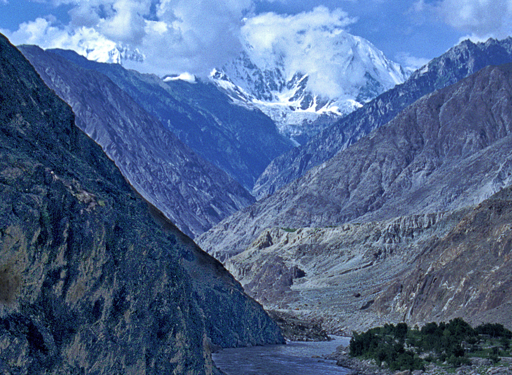
The Indus Gorge is formed by the Indus River as it skirts the Nanga Parbat massif, the western anchor of the Greater Himalayas, and before it debouches into the plains of Punjab, Pakistan, Punjab in Pakistan. The gorge is deep near the Nanga Parbat. The massive amounts of erosion due to the Indus River following the capture and rerouting through that area is thought to bring middle and lower crustal rocks to the surface. Gilgit is the westernmost tributary of the Indus River. See also * Geology of the Himalayas * Rigvedic rivers References Indus River {{Pakistan-geo-stub ... [...More Info...] [...Related Items...] OR: [Wikipedia] [Google] [Baidu] |
Nanga Parbat Indus Gorge , name of African traditional healer in Zimbabwe
{{disambig ...
Nanga may be: *Nanga (instrument), an Egyptian musical instrument *Nanga (Japanese painting) *Nanga Brook, Western Australia *Nanga of Kongo, second ruler or manikongo of the Central African kingdom of Kongo *Nanga subcaste of the Sial (tribe) in Pakistan *N'anga ''Nganga'' is a Kikongo language term for herbalist or Faith healing, spiritual healer in many African societies and also in many societies of the African diaspora such as those in Haiti, Brazil, and Cuba. It is derived from ''*-ganga'' in Prot ... [...More Info...] [...Related Items...] OR: [Wikipedia] [Google] [Baidu] |
Indus River
The Indus ( ) is a transboundary river of Asia and a trans-Himalayan river of South and Central Asia. The river rises in mountain springs northeast of Mount Kailash in Western Tibet, flows northwest through the disputed region of Kashmir, Quote: "Kashmir, region of the northwestern Indian subcontinent. It is bounded by the Uygur Autonomous Region of Xinjiang to the northeast and the Tibet Autonomous Region to the east (both parts of China), by the Indian states of Himachal Pradesh and Punjab to the south, by Pakistan to the west, and by Afghanistan to the northwest. The northern and western portions are administered by Pakistan and comprise three areas: Azad Kashmir, Gilgit, and Baltistan, ... The southern and southeastern portions constitute the Indian state of Jammu and Kashmir. The Indian- and Pakistani-administered portions are divided by a "line of control" agreed to in 1972, although neither country recognizes it as an international boundary. In addition, China became ... [...More Info...] [...Related Items...] OR: [Wikipedia] [Google] [Baidu] |
Nanga Parbat
Nanga Parbat ( ur, ) (; ), known locally as Diamer () which means “king of the mountains”, is the ninth-highest mountain on Earth, its summit at above sea level. Lying immediately southeast of the northernmost bend of the Indus River in the Gilgit-Baltistan region of Pakistan-administered Kashmir, Nanga Parbat is the westernmost major peak of the Himalayas, and thus in the traditional view of the Himalayas as bounded by the Indus and Yarlung Tsangpo/Brahmaputra rivers, it is the western anchor of the entire mountain range. Nanga Parbat is one of the 14 eight-thousanders. An immense, dramatic peak rising far above its surrounding terrain, Nanga Parbat is known to be a difficult climb, and has earned the nickname ''Killer Mountain'' for its high number of climber fatalities. Etymology The name Nanga Parbat is derived from the Sanskrit words ''nagna'' and ''parvata'', which, when combined, translate to "Naked Mountain". The mountain is known locally by its Tibetan name ''D ... [...More Info...] [...Related Items...] OR: [Wikipedia] [Google] [Baidu] |
Greater Himalayas
The Great Himalayas or Greater Himalayas or Himadri is the highest mountain range of the Himalayan Range.Hussain, MajidGeography of India/ref> The world's highest peak, Mount Everest, as well as other "near−highest" peaks, such as Kangchenjunga, Lhotse, and Nanga Parbat, are part of the Greater Himalayas range. The total west to east extension of the Great Himalayas is 2400 km (1500 miles) and their average elevation is 6000 m (20000 ft.). Several glaciers are contained within the range, including Gangotri Glacier, and Satopanth Glacier. Political entities which have territory in this range include India, China, Nepal, Pakistan, Bhutan, and Tibet Tibet (; ''Böd''; ) is a region in East Asia, covering much of the Tibetan Plateau and spanning about . It is the traditional homeland of the Tibetan people. Also resident on the plateau are some other ethnic groups such as Monpa people, .... See also * * References G Mountain ranges of China M ... [...More Info...] [...Related Items...] OR: [Wikipedia] [Google] [Baidu] |
Debouche
In hydrology, a debouch (or debouche) is a place where runoff from a small, confined space discharges into a larger, broader body of water. The word is derived from the French verb ''déboucher'' (), which means "to unblock, to clear". The term also has a military usage. Geology In fluvial geomorphology, a debouch is a place where runoff from a small, confined space emerges into a larger, broader space. Common examples are when a stream runs into a river or when a river runs into an ocean. Debouching can generate massive amounts of sediment transport. When a narrow stream travels down a mountain pass into a basin, an alluvial fan will form from the mass deposit of the sediment. The four largest rivers (the Amazon, the Ganges-Brahmaputra, the Yangtze and the Yellow) are responsible for 20% of the global discharge of sediment in to the oceans by debouches. Geography In fluvial geography, a debouch is a place where a body of water pours forth from a narrow opening. Some examples ar ... [...More Info...] [...Related Items...] OR: [Wikipedia] [Google] [Baidu] |
Punjab, Pakistan
Punjab (; , ) is one of the four provinces of Pakistan. Located in central-eastern region of the country, Punjab is the second-largest province of Pakistan by land area and the largest province by population. It shares land borders with the Pakistani provinces of Khyber Pakhtunkhwa to the north-west, Balochistan to the south-west and Sindh to the south, as well as Islamabad Capital Territory to the north-west and Autonomous Territory of AJK to the north. It shares an International border with the Indian states of Rajasthan and Punjab to the east and Indian-administered Kashmir to the north-east. Punjab is the most fertile province of the country as River Indus and its four major tributaries Ravi, Jhelum, Chenab and Sutlej flow through it. The province forms the bulk of the transnational Punjab region, now divided among Pakistan and India. The provincial capital is Lahore — a cultural, modern, historical, economic, and cosmopolitan centre of Pakistan. Other major cities ... [...More Info...] [...Related Items...] OR: [Wikipedia] [Google] [Baidu] |
Erosion
Erosion is the action of surface processes (such as water flow or wind) that removes soil, rock, or dissolved material from one location on the Earth's crust, and then transports it to another location where it is deposited. Erosion is distinct from weathering which involves no movement. Removal of rock or soil as clastic sediment is referred to as ''physical'' or ''mechanical'' erosion; this contrasts with ''chemical'' erosion, where soil or rock material is removed from an area by dissolution. Eroded sediment or solutes may be transported just a few millimetres, or for thousands of kilometres. Agents of erosion include rainfall; bedrock wear in rivers; coastal erosion by the sea and waves; glacial plucking, abrasion, and scour; areal flooding; wind abrasion; groundwater processes; and mass movement processes in steep landscapes like landslides and debris flows. The rates at which such processes act control how fast a surface is eroded. Typically, physical erosion procee ... [...More Info...] [...Related Items...] OR: [Wikipedia] [Google] [Baidu] |
Tectonics (journal)
''Tectonics'' is a peer-reviewed scientific journal of geology focusing on tectonics. It is published by the American Geophysical Union in collaboration with the European Geosciences Union. The journal is edited by John Geissman (University of Texas at Dallas), Laurent Jolivet ( Institut des Sciences de la Terre de Paris), Nathan Niemi (University of Michigan) and Taylor Schildgen (University of Potsdam). Abtrascting and indexing The journal is abstracted and indexed in the following bibliographic databases: According to the ''Journal Citation Reports'', the journal has a 2017 impact factor The impact factor (IF) or journal impact factor (JIF) of an academic journal is a scientometric index calculated by Clarivate that reflects the yearly mean number of citations of articles published in the last two years in a given journal, as i ... of 3.58. References External links * Publications established in 1982 English-language journals Geology journals American Geophy ... [...More Info...] [...Related Items...] OR: [Wikipedia] [Google] [Baidu] |
Geology Of The Himalayas
The geology of the Himalayas is a record of the most dramatic and visible creations of the immense mountain range formed by plate tectonic forces and sculpted by weathering and erosion. The Himalayas, which stretch over 2400 km between the Namcha Barwa syntaxis at the eastern end of the mountain range and the Nanga Parbat syntaxis at the western end, are the result of an ongoing orogeny — the collision of the continental crust of two tectonic plates, namely, the Indian Plate thrusting into the Eurasian Plate. The Himalaya-Tibet region supplies fresh water for more than one-fifth of the world population, and accounts for a quarter of the global sedimentary budget. Topographically, the belt has many superlatives: the highest rate of uplift (nearly 10 mm/year at Nanga Parbat), the highest relief (8848 m at Mt. Everest Chomolangma), among the highest erosion rates at 2–12 mm/yr, the source of some of the greatest rivers and the highest concentration of ... [...More Info...] [...Related Items...] OR: [Wikipedia] [Google] [Baidu] |
Rigvedic Rivers
Rivers play a prominent part in the hymns of the ''Rigveda'', and consequently in early Vedic religion. Vedic texts have a wide geographical horizon, speaking of oceans, rivers, mountains and deserts. The Vedic land is described as a land of the seven rivers (''sapta sindhavaḥ''; sa, सप्तसिन्धवः) flowing into the ocean. It encompasses the northwestern Indian subcontinent from Gandhara to Kurukshetra. Geography of the Rigveda Identification of Rigvedic hydronyms has engaged multiple historians; it is the single most important way of establishing the geography and chronology of the early Vedic period. Rivers with certain identifications stretch from eastern Afghanistan to the western Gangetic plain, clustering in the Punjab. The region's name comes from پنج, ''panj'', 'five' and آب, ''āb'', 'water' thus " five waters", a Persianized form of the Indo-Aryan ''Panchanada'' meaning "five rivers". Many have cognates in Avestan. The same names were ... [...More Info...] [...Related Items...] OR: [Wikipedia] [Google] [Baidu] |


