|
IRS-P5
Cartosat-1 (formerly IRS-P5) is a stereoscopic Earth observation satellite in a Sun-synchronous orbit, and the first one of the Cartosat series of satellites. The eleventh satellite of ISRO in Indian Remote Sensing Satellite (IRS) series. The satellite was launched by Indian Space Research Organisation and is operated by NTRO. Weighing around 1560 kg at launch, its applications will mainly be towards cartography in India. Launch It was launched by PSLV-C6, on 5 May 2005 at 04:44:00 UTC from the newly built Second Launch Pad at Sriharikota. Images from the satellite will be available from GeoEye for worldwide distribution. The satellite covers the entire globe in 1867 orbits on a 126-day cycle. Adjacent paths are covered by a separation of eleven days. History Department of Space (DOS), government of India, has launched a series of satellites for Earth's resource management and monitoring. These satellites have been very successful in providing data in various scales ... [...More Info...] [...Related Items...] OR: [Wikipedia] [Google] [Baidu] |
PSLV-C6
PSLV-C6 was the sixth operational launch and overall ninth mission of the PSLV program. This launch was also the fifty-fourth launch by Indian Space Research Organisation since its first mission on 1 January 1962. The vehicle carried and injected India's two satellites; Cartosat-1 (a.k.a. IRS-P5) and HAMSAT into the Sun-synchronous orbit. PSLV-C6 was launched at 04:44 hours Coordinated Universal Time (10:14 hours Indian Standard Time) on 5 May 2005 from the Satish Dhawan Space Centre Second Launch Pad, second launch pad of the Satish Dhawan Space Centre. Mission highlights *Sixth operational launch of the PSLV program. *Overall ninth mission of the PSLV program. *Overall fifty-fourth launch by Indian Space Research Organisation. *First flight to be launched from the Satish Dhawan Space Centre Second Launch Pad, second launch pad of Satish Dhawan Space Centre. *Carried and injected two satellites built by Indian Space Research Organisation, ISRO. Mission parameters * Mass: ** ''Tot ... [...More Info...] [...Related Items...] OR: [Wikipedia] [Google] [Baidu] |
Indian Space Research Organisation
The Indian Space Research Organisation (ISRO; ) is the national space agency of India, headquartered in Bengaluru. It operates under the Department of Space (DOS) which is directly overseen by the Prime Minister of India, while the Chairman of ISRO acts as the executive of DOS as well. ISRO is India's primary agency for performing tasks related to space-based applications, space exploration and the development of related technologies. It is one of six government space agencies in the world which possess full launch capabilities, deploy cryogenic engines, launch extraterrestrial missions and operate large fleets of artificial satellites. The Indian National Committee for Space Research (INCOSPAR) was established by Jawaharlal Nehru under the Department of Atomic Energy (DAE) in 1962, on the urging of scientist Vikram Sarabhai, recognising the need in space research. INCOSPAR grew and became ISRO in 1969, within DAE. In 1972, the government of India set up a Space Commissi ... [...More Info...] [...Related Items...] OR: [Wikipedia] [Google] [Baidu] |
Cartosat
The Cartosat is a series of Indian optical earth observation satellites built and operated by the Indian Space Research Organisation (ISRO). The Cartosat series is a part of the Indian Remote Sensing Program. They are used for Earth's resource management, defence services and monitoring. History The Department of Space (DoS) had launched and managed the IRS series of remote sensing satellites for Earth's resource management and monitoring. These satellites were very successful in providing data in various scales ranging from 1:1 Million to 1:12,500 scale. Each of the IRS missions ensured data continuity while introducing improvements in the spatial, spectral and radiometric resolutions. Considering increased demand for large scale and topographic mapping data, the DoS launched the expanded Cartosat series of remote sensing satellites. The first satellite of the series, Cartosat-1, was launched in 2005. Satellites Cartosat-1 Cartosat-1 was launched by PSLV-C6 on 5 May ... [...More Info...] [...Related Items...] OR: [Wikipedia] [Google] [Baidu] |
Earth Observation Satellite
An Earth observation satellite or Earth remote sensing satellite is a satellite used or designed for Earth observation (EO) from orbit, including spy satellites and similar ones intended for non-military uses such as environmental monitoring, meteorology, cartography and others. The most common type are Earth imaging satellites, that take satellite images, analogous to aerial photographs; some EO satellites may perform remote sensing without forming pictures, such as in GNSS radio occultation. The first occurrence of satellite remote sensing can be dated to the launch of the first artificial satellite, Sputnik 1, by the Soviet Union on October 4, 1957. Sputnik 1 sent back radio signals, which scientists used to study the ionosphere. The United States Army Ballistic Missile Agency launched the first American satellite, Explorer 1, for NASA’s Jet Propulsion Laboratory on January 31, 1958. The information sent back from its radiation detector led to the discovery of the Earth's ... [...More Info...] [...Related Items...] OR: [Wikipedia] [Google] [Baidu] |
List Of Indian Satellites
This list covers most artificial satellites built in and operated by the India, Republic of India. India has been successfully launching satellites of various types from 1975. Apart from Indian rockets, these satellites have been launched from various launch vehicle, vehicles, including American, Russian and European rockets sometimes as well. The organisation responsible for India's space program is Indian Space Research Organisation (ISRO) and it shoulders the bulk of the responsibility of designing, building, launching and operating these satellites. Legend This is a list of Indian (wholly or partially owned, wholly or partially designed and/or manufactured) satellites and orbital space crafts, both operated by the Indian government (ISRO, Indian defence forces, other government agencies) or private (educational and research) entities. All satellite launches marked successful have completed at least one full orbital flight (no sub-orbital flights have been included in this l ... [...More Info...] [...Related Items...] OR: [Wikipedia] [Google] [Baidu] |
Charge-coupled Device
A charge-coupled device (CCD) is an integrated circuit containing an array of linked, or coupled, capacitors. Under the control of an external circuit, each capacitor can transfer its electric charge to a neighboring capacitor. CCD sensors are a major technology used in digital imaging. In a CCD image sensor, pixels are represented by p-doped metal–oxide–semiconductor (MOS) capacitors. These MOS capacitors, the basic building blocks of a CCD, are biased above the threshold for inversion when image acquisition begins, allowing the conversion of incoming photons into electron charges at the semiconductor-oxide interface; the CCD is then used to read out these charges. Although CCDs are not the only technology to allow for light detection, CCD image sensors are widely used in professional, medical, and scientific applications where high-quality image data are required. In applications with less exacting quality demands, such as consumer and professional digital cameras, act ... [...More Info...] [...Related Items...] OR: [Wikipedia] [Google] [Baidu] |
National Remote Sensing Centre
National Remote Sensing Centre (Hindi: राष्ट्रीय सुदूर संवेदन केन्द्र), or NRSC, located in Hyderabad, Telangana is one of the centres of the Indian Space Research Organisation The Indian Space Research Organisation (ISRO; ) is the national space agency of India, headquartered in Bengaluru. It operates under the Department of Space (DOS) which is directly overseen by the Prime Minister of India, while the Chairman ... (ISRO). NRSC manages data from aerial and satellite sources. Finances NRSC is mostly financed by State and Central Government funds but also do commercial business by selling satellite images and provide Consultancy to various government, private organisations. According to RTI number: NRESC/R/E/20/00021, revenues and grants values are published for 2014 to 2019 year. References External links * {{Navboxes , list = {{ISRO facilities {{Indian space programme {{Public-sector space agencies {{Auth ... [...More Info...] [...Related Items...] OR: [Wikipedia] [Google] [Baidu] |
Electromagnetic Spectrum
The electromagnetic spectrum is the range of frequencies (the spectrum) of electromagnetic radiation and their respective wavelengths and photon energies. The electromagnetic spectrum covers electromagnetic waves with frequencies ranging from below one hertz to above 1025 hertz, corresponding to wavelengths from thousands of kilometers down to a fraction of the size of an atomic nucleus. This frequency range is divided into separate bands, and the electromagnetic waves within each frequency band are called by different names; beginning at the low frequency (long wavelength) end of the spectrum these are: radio waves, microwaves, infrared, visible light, ultraviolet, X-rays, and gamma rays at the high-frequency (short wavelength) end. The electromagnetic waves in each of these bands have different characteristics, such as how they are produced, how they interact with matter, and their practical applications. There is no known limit for long and short wavelengths. Extreme ultr ... [...More Info...] [...Related Items...] OR: [Wikipedia] [Google] [Baidu] |
Visible Spectrum
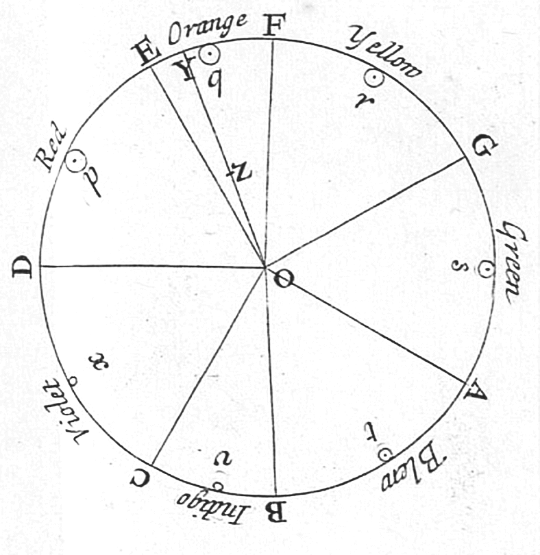
The visible spectrum is the portion of the electromagnetic spectrum that is visual perception, visible to the human eye. Electromagnetic radiation in this range of wavelengths is called ''visible light'' or simply light. A typical human eye will respond to wavelengths from about 380 to about 750 nanometers. In terms of frequency, this corresponds to a band in the vicinity of 400–790 Terahertz (unit), terahertz. These boundaries are not sharply defined and may vary per individual. Under optimal conditions these limits of human perception can extend to 310 nm (ultraviolet) and 1100 nm (near infrared). The optical spectrum is sometimes considered to be the same as the visible spectrum, but some authors define the term more broadly, to include the ultraviolet and infrared parts of the electromagnetic spectrum as well. The spectrum does not contain all the colors that the human visual system can distinguish. ''Excitation purity, Unsaturated colors'' such as pink, or ... [...More Info...] [...Related Items...] OR: [Wikipedia] [Google] [Baidu] |
Earth
Earth is the third planet from the Sun and the only astronomical object known to harbor life. While large volumes of water can be found throughout the Solar System, only Earth sustains liquid surface water. About 71% of Earth's surface is made up of the ocean, dwarfing Earth's polar ice, lakes, and rivers. The remaining 29% of Earth's surface is land, consisting of continents and islands. Earth's surface layer is formed of several slowly moving tectonic plates, which interact to produce mountain ranges, volcanoes, and earthquakes. Earth's liquid outer core generates the magnetic field that shapes the magnetosphere of the Earth, deflecting destructive solar winds. The atmosphere of the Earth consists mostly of nitrogen and oxygen. Greenhouse gases in the atmosphere like carbon dioxide (CO2) trap a part of the energy from the Sun close to the surface. Water vapor is widely present in the atmosphere and forms clouds that cover most of the planet. More solar e ... [...More Info...] [...Related Items...] OR: [Wikipedia] [Google] [Baidu] |


