|
Hwamyeong Station
Hwamyeong station is a train station in northern Busan, South Korea. It was most recently rebuilt in 1999. The train and subway stations are not connected directly. Tourist attractions * Geumgok-dong Ulypaechong * Daecheon river baby temple See also *Transportation in South Korea Transportation in South Korea is provided by extensive networks of railways, highways, bus routes, ferry services and air routes that traverse the country. South Korea is the third country in the world to operate a maglev train, which is an automa ... References External links {{Gyeongbu Line Railway stations in Busan Buk District, Busan Railway stations in South Korea opened in 1999 ... [...More Info...] [...Related Items...] OR: [Wikipedia] [Google] [Baidu] |
Hwamyeong-dong
Hwamyeong is a region in Buk-gu, northern Busan, South Korea. It is situated along the east bank of the Nakdong River, and since 2003 has been divided into three '' dong'', Hwamyeong 1, 2, and 3-dong. The total area of the three ''dong'' is approximately . It was designed to serve as a commuter town for Busan, and was home to about 99,000 people as of February 2020. Name There are many different theories regarding the origination of the name Hwamyeong. The most reliable theory is that Mt. Geumjeong, the mountain surrounding Hwamyeong, was once called Mt. Hwa, or Hwasan. This names derives from the mountain being described as an ideal or bright place, and since the Chinese letter for ideal is pronounced 'myeong' in Korean, the name Hwamyeong thus refers to an "ideal bright place." Another theory is that the district's original name was ''Hwe-Bulgi'', which means 'bright sun' or 'red sun'. The literal translation of Hwamyeong, as it is currently spelled, is 'brightly shining,' ... [...More Info...] [...Related Items...] OR: [Wikipedia] [Google] [Baidu] |
Buk District, Busan
Buk District (literally ''north district'') is a '' gu'', or district, in north central Busan, South Korea. Buk-gu covers a surface of 38.30 km² is home to about 335,000 people. It attained the status of ''gu'' in 1978. Administrative divisions Buk-gu is divided into 5 legal ''dong'', which all together comprise 13 administrative ''dong'', as follows: * Gupo-dong (3 administrative ''dong'') * Geumgok-dong * Hwamyeong-dong (3 administrative ''dong'') * Deckcheon-dong (3 administrative ''dong'') * Mandeok-dong (3 administrative ''dong'') Sister cities * Jiaozhou, China Notable people from Buk District * Seungwoo (Real Name: ''Han Seung-woo'', Hangul: 한승우), singer-songwriter, rapper, dancer and K-pop idol, member of K-pop boygroup Victon and former member of K-pop boygroup X1 * Jungkook (Real Name: ''Jeon Jeong-guk'', Hangul: 전정국), K-pop idol, singer-songwriter, producer, main vocalist and lead dancer of BTS See also * Geography of South Korea * Subd ... [...More Info...] [...Related Items...] OR: [Wikipedia] [Google] [Baidu] |
South Korea
South Korea, officially the Republic of Korea (ROK), is a country in East Asia, constituting the southern part of the Korea, Korean Peninsula and sharing a Korean Demilitarized Zone, land border with North Korea. Its western border is formed by the Yellow Sea, while its eastern border is defined by the Sea of Japan. South Korea claims to be the sole legitimate government of the entire peninsula and List of islands of South Korea, adjacent islands. It has a Demographics of South Korea, population of 51.75 million, of which roughly half live in the Seoul Capital Area, the List of metropolitan areas by population, fourth most populous metropolitan area in the world. Other major cities include Incheon, Busan, and Daegu. The Korean Peninsula was inhabited as early as the Lower Paleolithic period. Its Gojoseon, first kingdom was noted in Chinese records in the early 7th century BCE. Following the unification of the Three Kingdoms of Korea into Unified Silla, Silla and Balhae in the ... [...More Info...] [...Related Items...] OR: [Wikipedia] [Google] [Baidu] |
Gyeongbu Line
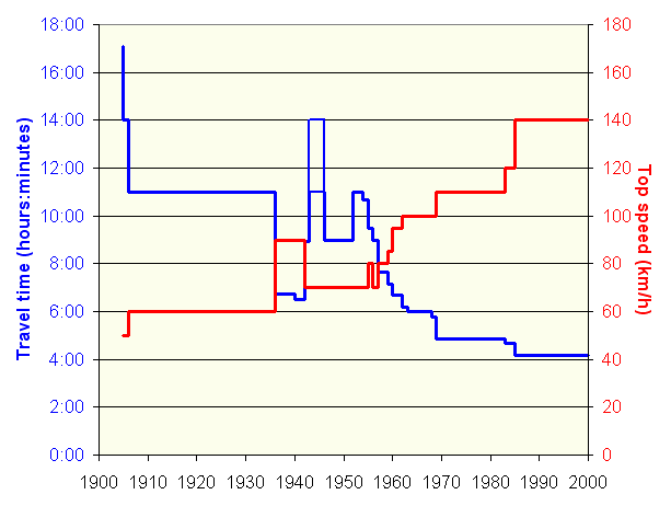
The Gyeongbu Line (''Gyeongbuseon'') is a railway line in South Korea and is considered to be the most important and one of the oldest ones in the country. It was constructed in 1905, connecting Seoul with Busan via Suwon, Daejeon, and Daegu. It is by far the most heavily travelled rail line in South Korea. All types of Korea Train Express, high-speed, express, local, and freight trains provide frequent service along its entire length. History In 1894–1895, the Empire of Japan and Qing Dynasty, Qing China fought the First Sino-Japanese War for influence over Korea. Following the war, Japan competed with the Russian Empire's railway expansion in Northeast Asia, which led it to seek the right from the Korean Empire to build a railway from Busan to Keijō. This railway line was intended by Japan to solidify its strategic positions against Russia, which it would later go to Russo-Japanese War, war. Surveying began in 1896, and in spite of local protests, the Korean Empire gav ... [...More Info...] [...Related Items...] OR: [Wikipedia] [Google] [Baidu] |
Korail
The Korea Railroad Corporation (Korean: 한국철도공사, Hanja: ), branded as KORAIL (코레일, officially changed to in November 2019), is the national railway operator in South Korea. Currently, KORAIL is a public corporation, managed by Ministry of Land, Infrastructure and Transportation. KORAIL operates intercity/regional, commuter/metro and freight trains throughout South Korea, and has its headquarters in Daejeon. History Historically, the South Korean railway network was managed by the ''Railroad Administration Bureau'' of the Ministry of Transportation before 1963. On 1 September 1963, the bureau became an agency that was known as ''Korean National Railroad'' (KNR) in English. In the early 2000s, split and public corporatization of KNR was decided by the South Korean government, and in 2003, KNR adopted the current KORAIL logo in blue to prepare corporatization. On 1 January 2005, KNR was split into ''Korea Railroad Corporation'' (KORAIL), which succeeded ra ... [...More Info...] [...Related Items...] OR: [Wikipedia] [Google] [Baidu] |
Hwamyeong Stn
Hwamyeong is a region in Buk-gu, northern Busan, South Korea. It is situated along the east bank of the Nakdong River, and since 2003 has been divided into three '' dong'', Hwamyeong 1, 2, and 3-dong. The total area of the three ''dong'' is approximately . It was designed to serve as a commuter town for Busan, and was home to about 99,000 people as of February 2020. Name There are many different theories regarding the origination of the name Hwamyeong. The most reliable theory is that Mt. Geumjeong, the mountain surrounding Hwamyeong, was once called Mt. Hwa, or Hwasan. This names derives from the mountain being described as an ideal or bright place, and since the Chinese letter for ideal is pronounced 'myeong' in Korean, the name Hwamyeong thus refers to an "ideal bright place." Another theory is that the district's original name was ''Hwe-Bulgi'', which means 'bright sun' or 'red sun'. The literal translation of Hwamyeong, as it is currently spelled, is 'brightly shining,' ... [...More Info...] [...Related Items...] OR: [Wikipedia] [Google] [Baidu] |
Busan
Busan (), officially known as is South Korea's most populous city after Seoul, with a population of over 3.4 million inhabitants. Formerly romanized as Pusan, it is the economic, cultural and educational center of southeastern South Korea, with its port being Korea's busiest and the sixth-busiest in the world. The surrounding "Southeastern Maritime Industrial Region" (including Ulsan, South Gyeongsang, Daegu, and some of North Gyeongsang and South Jeolla) is South Korea's largest industrial area. The large volumes of port traffic and urban population in excess of 1 million make Busan a Large-Port metropolis using the Southampton System of Port-City classification . Busan is divided into 15 major administrative districts and a single county, together housing a population of approximately 3.6 million. The full metropolitan area, the Southeastern Maritime Industrial Region, has a population of approximately 8 million. The most densely built-up areas of the city are situated in ... [...More Info...] [...Related Items...] OR: [Wikipedia] [Google] [Baidu] |
Daecheon River
Boryeong (), commonly known as Daecheon, is a city in South Chungcheong Province, South Korea. It is located on the coast of the Yellow Sea. It lies on the Janghang Line railroad, which connects it to Seoul via the Gyeongbu Line. It is also connected to the Seohaean Expressway. Boryeong is known around Korea for its beaches, particularly Daecheon Beach, and its annual mud festival around July, Boryeong Mud Festival. The city's beach-mud is widely touted for its cosmetic properties. As elsewhere along the southwest coast of the Korean peninsula, there are numerous small islands, many of which are connected by ferry to Daecheon Port. Boryeong gained its present boundaries in 1995, with the merger of Boryeong-gun and Daecheon City. Previously, the 2 entities were separated in 1986, and before that time had been united under the name Boryeong County (Boryeong-gun) since the Joseon Dynasty. Overview Boryeong public schools are operated by the Chungnam Office of Education. There are n ... [...More Info...] [...Related Items...] OR: [Wikipedia] [Google] [Baidu] |
Transportation In South Korea
Transportation in South Korea is provided by extensive networks of railways, highways, bus routes, ferry services and air routes that traverse the country. South Korea is the third country in the world to operate a maglev train, which is an automatically run people mover at Incheon International Airport. History Development of modern infrastructure began with the first Five-Year Development Plan (1962–66), which included the construction of 275 kilometers of railways and several small highway projects. Construction of the Gyeongbu Expressway, which connects the two major cities of Seoul and Busan, was completed on 7 July 1970. The 1970s saw increased commitment to infrastructure investments. The third Five-Year Development Plan (1972–76) added the development of airports, seaports. The Subway system was built in Seoul, the highway network was expanded by 487 km and major port projects were started in Pohang, Ulsan, Masan, Incheon and Busan. The railroad network experie ... [...More Info...] [...Related Items...] OR: [Wikipedia] [Google] [Baidu] |
Railway Stations In Busan
Rail transport (also known as train transport) is a means of transport that transfers passengers and goods on wheeled vehicles running on rails, which are incorporated in Track (rail transport), tracks. In contrast to road transport, where the vehicles run on a prepared flat surface, rail vehicles (rolling stock) are directionally guided by the tracks on which they run. Tracks usually consist of steel rails, installed on Railroad tie, sleepers (ties) set in track ballast, ballast, on which the rolling stock, usually fitted with metal wheels, moves. Other variations are also possible, such as "slab track", in which the rails are fastened to a concrete foundation resting on a prepared subsurface. Rolling stock in a rail transport system generally encounters lower friction, frictional resistance than rubber-tyred road vehicles, so passenger and freight cars (carriages and wagons) can be coupled into longer trains. The rail transport operations, operation is carried out by a ... [...More Info...] [...Related Items...] OR: [Wikipedia] [Google] [Baidu] |


