|
Hurricane Norbert (2008)
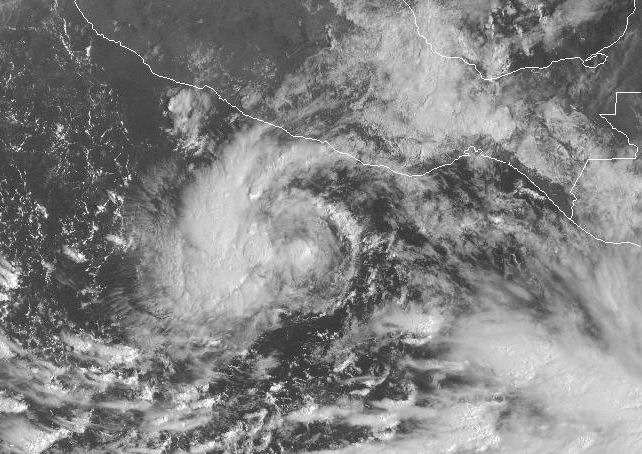
Hurricane Norbert is tied with Hurricane Jimena (2009), Hurricane Jimena as the strongest tropical cyclone to strike the west coast of Baja California Sur in recorded history. The fifteenth named storm, seventh hurricane, and second major hurricane of the 2008 Pacific hurricane season, 2008 hurricane season, Norbert originated as a tropical depression from a tropical wave south of Acapulco on October 3. Strong wind shear initially prevented much development, but the cyclone encountered a more favorable environment as it moved westward. On October 5, the National Hurricane Center (NHC) upgraded the depression to Tropical Storm Norbert, and the system intensified further to attain hurricane intensity by October 6. After undergoing a period of rapid deepening, Norbert reached its peak intensity as a Category 4 on the Saffir–Simpson hurricane wind scale, with maximum sustained winds of and a minimum atmospheric pressure, barometric pressure of . As the cyclone rou ... [...More Info...] [...Related Items...] OR: [Wikipedia] [Google] [Baidu] |
Baja California Sur
Baja California Sur (; 'South Lower California'), officially the Free and Sovereign State of Baja California Sur ( es, Estado Libre y Soberano de Baja California Sur), is the least populated state and the 31st admitted state of the 32 federal entities which comprise the 31 States of Mexico. It is also the ninth-largest Mexican state in terms of area. Before becoming a state on 8 October 1974, the area was known as the ''El Territorio Sur de Baja California'' ("South Territory of Lower California"). It has an area of , or 3.57% of the land mass of Mexico, and occupies the southern half of the Baja California Peninsula, south of the 28th parallel, plus the uninhabited Rocas Alijos in the Pacific Ocean. It is bordered to the north by the state of Baja California, to the west by the Pacific Ocean, and to the east by the Gulf of California. The state has maritime borders with Sonora and Sinaloa to the east, across the Gulf of California. The state is home to the tourist resor ... [...More Info...] [...Related Items...] OR: [Wikipedia] [Google] [Baidu] |
Álamos
Álamos () is a town in Álamos Municipality in the Mexican state of Sonora, in northwestern Mexico. Historically an important center of silver mining, the town's economy is now dominated by the tourist sector. Designated a ''pueblo mágico'' due to its architecture, the town is host to several arts festivals, most notably the Festival Cultural "Alfonso Ortíz Tirado". It also hosts the Alamos Alliance, a yearly summit of economic policy makers, academics and business leaders founded and led by Arnold Harberger that has led to the town being called the "Little Mexican Davos". Name The Municipality of Álamos derives its name from the ( poplar or cottonwood) tree. Several impressive specimens are found in one of its two principal plazas, the Alameda. The nearby hamlet, El Sabinito, located within the municipality, also derives its name from a tree, the (" Montezuma cypress"). History The area was named by the conquistador Francisco Vásquez de Coronado. His expedition of ... [...More Info...] [...Related Items...] OR: [Wikipedia] [Google] [Baidu] |
Eye (cyclone)
The eye is a region of mostly calm weather at the center of tropical cyclones. The eye of a storm is a roughly circular area, typically in diameter. It is surrounded by the ''eyewall'', a ring of towering thunderstorms where the most severe weather and highest winds occur. The cyclone's lowest barometric pressure occurs in the eye and can be as much as 15 percent lower than the pressure outside the storm. In strong tropical cyclones, the eye is characterized by light winds and clear skies, surrounded on all sides by a towering, symmetric eyewall. In weaker tropical cyclones, the eye is less well defined and can be covered by the central dense overcast, an area of high, thick clouds that show up brightly on satellite imagery. Weaker or disorganized storms may also feature an eyewall that does not completely encircle the eye or have an eye that features heavy rain. In all storms, however, the eye is the location of the storm's minimum barometric pressure—where the atmospheric p ... [...More Info...] [...Related Items...] OR: [Wikipedia] [Google] [Baidu] |
Zihuatanejo
Zihuatanejo (), or Ixtapa-Zihuatanejo, is the fourth-largest city in the Mexican state of Guerrero. It was known by 18th century English mariners as Chequetan or Seguataneo. Politically the city belongs to the municipality of Zihuatanejo de Azueta in the western part of Guerrero, but both are commonly referred to as Zihuatanejo. It is on the Pacific Coast, about northwest of Acapulco and further south in latitude than Honolulu, Hawaii. Zihuatanejo belongs to a section of the Mexican Pacific Coast known as the Costa Grande. This town has been developed as a tourist attraction along with the modern tourist resort of Ixtapa, away. However, Zihuatanejo has kept its traditional town feel. The town is located on a well-protected bay which is popular with private boat owners during the winter months. There are two possible origins for the name Zihuatanejo. One origin might be from the Purépecha language meaning "water of the yellow mountain"; another possible origin might be from N ... [...More Info...] [...Related Items...] OR: [Wikipedia] [Google] [Baidu] |
Dvorak Technique
The Dvorak technique (developed between 1969 and 1984 by Vernon Dvorak) is a widely used system to estimate tropical cyclone intensity (which includes tropical depression, tropical storm, and hurricane/typhoon/intense tropical cyclone intensities) based solely on visible and infrared satellite images. Within the Dvorak satellite strength estimate for tropical cyclones, there are several visual patterns that a cyclone may take on which define the upper and lower bounds on its intensity. The primary patterns used are curved band pattern (T1.0-T4.5), shear pattern (T1.5–T3.5), central dense overcast (CDO) pattern (T2.5–T5.0), central cold cover (CCC) pattern, banding eye pattern (T4.0–T4.5), and eye pattern (T4.5–T8.0). Both the central dense overcast and embedded eye pattern use the size of the CDO. The CDO pattern intensities start at T2.5, equivalent to minimal tropical storm intensity (40 mph, 65 km/h). The shape of the central dense overcast is also c ... [...More Info...] [...Related Items...] OR: [Wikipedia] [Google] [Baidu] |
Tropical Cyclone Formation
Tropical cyclogenesis is the development and strengthening of a tropical cyclone in the atmosphere. The mechanisms through which tropical cyclogenesis occurs are distinctly different from those through which temperate cyclogenesis occurs. Tropical cyclogenesis involves the development of a warm-core cyclone, due to significant convection in a favorable atmospheric environment. Tropical cyclogenesis requires six main factors: sufficiently warm sea surface temperatures (at least ), atmospheric instability, high humidity in the lower to middle levels of the troposphere, enough Coriolis force to develop a low-pressure center, a pre-existing low-level focus or disturbance, and low vertical wind shear. Tropical cyclones tend to develop during the summer, but have been noted in nearly every month in most basins. Climate cycles such as ENSO and the Madden–Julian oscillation modulate the timing and frequency of tropical cyclone development. There is a limit on tropical cyclone ... [...More Info...] [...Related Items...] OR: [Wikipedia] [Google] [Baidu] |
Tropical Cyclone Forecast Model
A tropical cyclone forecast model is a computer program that uses meteorological data to forecast aspects of the future state of tropical cyclones. There are three types of models: statistical, dynamical, or combined statistical-dynamic. Dynamical models utilize powerful supercomputers with sophisticated mathematical modeling software and meteorological data to calculate future weather conditions. Statistical models forecast the evolution of a tropical cyclone in a simpler manner, by extrapolating from historical datasets, and thus can be run quickly on platforms such as personal computers. Statistical-dynamical models use aspects of both types of forecasting. Four primary types of forecasts exist for tropical cyclones: track, intensity, storm surge, and rainfall. Dynamical models were not developed until the 1970s and the 1980s, with earlier efforts focused on the storm surge problem. Track models did not show forecast skill when compared to statistical models until th ... [...More Info...] [...Related Items...] OR: [Wikipedia] [Google] [Baidu] |
TD Fifteen-E 2008 Oct 4 1445Z
TD, Td, or td may refer to: Arts, entertainment, and media Games and toys *Tails Doll *Toon Disney *Tech Deck, a type of fingerboard *''Ten Desires'', the thirteenth official game in the ''Touhou'' series * ''Test Drive'' (1987 video game), a driving simulation game *''Total Distortion'', a 1995 computer/mac adventure game *Tournament director (chess) or Tournament controller, the organizer and arbiter of a tournament, responsible for enforcing the tournament rules and the laws of chess *Tournament director (poker), the individual charged with running a poker tournament * Tournament director, in duplicate bridge *Tower defense, a genre of video games in which players repel enemies by strategically placing defensive towers *''Tower Dream'', a Super Famicom video game *Toronto Defiant, an Overwatch League team Music *Tangerine Dream, a seminal German krautrock group *Team Dresch, an American punk rock band *Tenacious D, a comedy rock duo * Throwdown (band), American straight ... [...More Info...] [...Related Items...] OR: [Wikipedia] [Google] [Baidu] |
Low Pressure Area
In meteorology, a low-pressure area, low area or low is a region where the atmospheric pressure is lower than that of surrounding locations. Low-pressure areas are commonly associated with inclement weather (such as cloudy, windy, with possible rain or storms), while high-pressure areas are associated with lighter winds and clear skies. Winds circle anti-clockwise around lows in the northern hemisphere, and clockwise in the southern hemisphere, due to opposing Coriolis forces. Low-pressure systems form under areas of wind divergence that occur in the upper levels of the atmosphere (aloft). The formation process of a low-pressure area is known as cyclogenesis. In meteorology, atmospheric divergence aloft occurs in two kinds of places: * The first is in the area on the east side of upper troughs, which form half of a Rossby wave within the Westerlies (a trough with large wavelength that extends through the troposphere). * A second is an area where wind divergence aloft occur ... [...More Info...] [...Related Items...] OR: [Wikipedia] [Google] [Baidu] |
Tropical Cyclogenesis
Tropical cyclogenesis is the development and strengthening of a tropical cyclone in the atmosphere. The mechanisms through which tropical cyclogenesis occurs are distinctly different from those through which temperate cyclogenesis occurs. Tropical cyclogenesis involves the development of a warm-core cyclone, due to significant convection in a favorable atmospheric environment. Tropical cyclogenesis requires six main factors: sufficiently warm sea surface temperatures (at least ), atmospheric instability, high humidity in the lower to middle levels of the troposphere, enough Coriolis force to develop a low-pressure center, a pre-existing low-level focus or disturbance, and low vertical wind shear. Tropical cyclones tend to develop during the summer, but have been noted in nearly every month in most basins. Climate cycles such as ENSO and the Madden–Julian oscillation modulate the timing and frequency of tropical cyclone development. There is a limit on tropical cyclo ... [...More Info...] [...Related Items...] OR: [Wikipedia] [Google] [Baidu] |
Gulf Of Tehuantepec
Gulf of Tehuantepec () is a large body of water on the Pacific coast of the Isthmus of Tehuantepec, southeastern Mexico, at . Many (but not all) Pacific hurricanes form in or near this body of water. A strong, gale-force wind called the Tehuano Tehuantepecer, or Tehuano wind, is a violent mountain-gap wind that travels through the Chivela Pass in southern Mexico, across the Isthmus of Tehuantepec. It is most common between October and February, with a summer minimum in July. It origina ... periodically blows out over the waters of the Gulf of Tehuantepec, inducing strong upwelling of nutrient-rich waters which support abundant sea life. The gulf is in the path of the lowest landform between Mexico and Northern Central America, allowing unhindered wind passage from the Gulf of Mexico, and the Eastern Pacific Ocean. Gulfs of Mexico Tehuantepec Landforms of Oaxaca {{Oaxaca-geo-stub ... [...More Info...] [...Related Items...] OR: [Wikipedia] [Google] [Baidu] |


