|
Highway 20 (Israel)
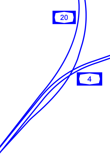
, length_km = 29 , direction_a = South , terminus_a = Rishon LeZion (Holot Interchange) , cities = Holon, Herzliya, Bat Yam, Tel Aviv, Givatayim, Ramat Gan , direction_b = North , terminus_b = Rishpon , junction = *Holon Interchange *Kibbutz Galuyot Interchange * La Guardia Interchange *Glilot Interchange , previous_route = 13 , previous_type = Hwy , next_route = 22 , next_type = Fwy , photo = , photo_notes = Aerial View of Highway 20 at Night Highway 20, more commonly known as the Ayalon Highway, or simply Ayalon ( he, נתיבי איילון, pronounced: ''"Netivei Ayalon"'', lit. "Ayalon lanes"), is a major intracity freeway in Gush Dan, Israel. The road runs along the eastern border of central Tel Aviv from north to south (with a planned east-west branch as well) and connects all of the major highways leading to the city—such as Highway 4 from Ashdod and the Southern regions, Highway 2 from Haifa and the Northern regions, Highway 5 from the East, and ... [...More Info...] [...Related Items...] OR: [Wikipedia] [Google] [Baidu] |
Rishon LeZion
Rishon LeZion ( he, רִאשׁוֹן לְצִיּוֹן , ''lit.'' First to Zion, Arabic: راشون لتسيون) is a city in Israel, located along the central Israeli coastal plain south of Tel Aviv. It is part of the Gush Dan metropolitan area. Founded in 1882 by Jewish immigrants from the Russian Empire who were part of the First Aliyah, it was the first Zionist settlement founded in the Land of Israel by the New Yishuv and the second Jewish farm settlement established in Ottoman Syria in the 19th century, after Petah Tikva. As of 2017, it was the fourth-largest city in Israel, with a population of . The city is a member of Forum 15, which is an association of fiscally autonomous cities in Israel that do not depend on national balancing or development grants. Etymology The name Rishon LeZion is derived from a verse from the Tanakh: "First to Zion are they, and I shall give herald to Jerusalem" ) (Isaiah 41:27) and literally translates as "First to Zion". History Ottoma ... [...More Info...] [...Related Items...] OR: [Wikipedia] [Google] [Baidu] |
Gush Dan
Gush Dan ( he, גּוּשׁ דָּן, ''lit.'' "Dan bloc") or Tel Aviv metropolitan area ( he, מֶטְרוֹפּוֹלִין תֵּל אָבִיב) is a conurbation in Israel, located along the country's Mediterranean coastline. There is no single formal definition of Gush Dan, though the term is in frequent use by both governmental bodies and the general public. It ranges from combining Tel Aviv with cities that form urban continuum with it, to the entire areas from both the Tel Aviv and the Central District, or sometimes the whole Metropolitan Area of Tel Aviv. which includes a small part of the Southern District as well. Gush Dan is the largest conurbation and metropolitan area in Israel, with the metropolitan area having an estimated population of 4,054,570 residents, 95% of whom are Israeli Jews. Cities in Gush Dan Population in cities as of the end of 2018: ;Over 400,000 * Tel Aviv-Yafo ;Over 200,000 *Rishon LeZion *Petah Tikva *Ashdod *Netanya *Bnei Brak ;Over ... [...More Info...] [...Related Items...] OR: [Wikipedia] [Google] [Baidu] |
Ayalon River
The Ayalon River ( he, נחל איילון, ''Nahal Ayalon''; Nahr el-Barideh or Wadi Musrara in Arabic) is a perennial stream in Israel, originating in the Judean Hills and discharging into the Yarkon River in the area of Tel Aviv. The total length of the Ayalon River is about 50 kilometres and it drains an area of 815 square kilometres. It begins in the Judean Hills northwest of Jerusalem near the Israeli settlements of Giv'at Ze'ev and Giv'on HaHadasha, flows down through the Ayalon Valley of the Shephelah region, reaches the Coastal Plain and passes near Ben Gurion Airport, is diverted from its original bed through an artificial concrete channel along the north-south Ayalon Freeway bordering central Tel Aviv on the east, and discharges into the Yarkon River in the Bavli quarter of Tel Aviv. East of Tel Aviv the Ayalon passes through the grounds of the new Ariel Sharon Park, a grand project centered on the former Hiriya waste dump and since 2004 one of the biggest environm ... [...More Info...] [...Related Items...] OR: [Wikipedia] [Google] [Baidu] |
Railway
Rail transport (also known as train transport) is a means of transport that transfers passengers and goods on wheeled vehicles running on rails, which are incorporated in tracks. In contrast to road transport, where the vehicles run on a prepared flat surface, rail vehicles (rolling stock) are directionally guided by the tracks on which they run. Tracks usually consist of steel rails, installed on sleepers (ties) set in ballast, on which the rolling stock, usually fitted with metal wheels, moves. Other variations are also possible, such as "slab track", in which the rails are fastened to a concrete foundation resting on a prepared subsurface. Rolling stock in a rail transport system generally encounters lower frictional resistance than rubber-tyred road vehicles, so passenger and freight cars (carriages and wagons) can be coupled into longer trains. The operation is carried out by a railway company, providing transport between train stations or freight customer facilit ... [...More Info...] [...Related Items...] OR: [Wikipedia] [Google] [Baidu] |
Jerusalem District
The Jerusalem District ( he, מחוז ירושלים; ar, منطقة القدس) is one of the six administrative districts of Israel. The district capital is Jerusalem. The Jerusalem District has a land area of 652 km2. The population of 1,159,900 is 66.3% Jewish and 32.1% Arab. A fifth (21%) of the Arabs in Israel live in the Jerusalem Municipality, which includes both East and West Jerusalem. Israel's annexation of East Jerusalem has not been recognized by the international community. The majority of Arabs in the Jerusalem District are Palestinians, eligible to apply for citizenship under Israeli law, but either declining to apply or unsuccessful. The minority are Arab citizens of Israel living in Abu Ghosh, Beit Safafa and East Jerusalem, where Arab professionals have settled since the late 1970s, mainly for the provision of legal and other services to the local population. The non-Jewish population is 95.2% Muslim, 3.5% Christian with the others unclassified by relig ... [...More Info...] [...Related Items...] OR: [Wikipedia] [Google] [Baidu] |
Jerusalem
Jerusalem (; he, יְרוּשָׁלַיִם ; ar, القُدس ) (combining the Biblical and common usage Arabic names); grc, Ἱερουσαλήμ/Ἰεροσόλυμα, Hierousalḗm/Hierosóluma; hy, Երուսաղեմ, Erusałēm. is a city in Western Asia. Situated on a plateau in the Judaean Mountains between the Mediterranean Sea, Mediterranean and the Dead Sea, it is one of the List of oldest continuously inhabited cities, oldest cities in the world and is considered to be a holy city for the three major Abrahamic religions: Judaism, Christianity, and Islam. Both Israelis and Palestinians claim Jerusalem as their Capital city, capital, as Israel maintains its primary governmental institutions there and the State of Palestine ultimately foresees it as its seat of power. Because of this dispute, Status of Jerusalem, neither claim is widely recognized internationally. Throughout History of Jerusalem, its long history, Jerusalem has been destroyed at least twice, Sie ... [...More Info...] [...Related Items...] OR: [Wikipedia] [Google] [Baidu] |
Highway 1 (Israel)
The following highways are numbered 1. For roads numbered A1, see list of A1 roads. For roads numbered B1, see list of B1 roads. For roads numbered M1, see List of M1 roads. For roads numbered N1, see list of N1 roads. For roads numbered S1, see List of highways numbered S1. International * AH1, Asian Highway 1, an international route from Japan to the Turkey, Turkish-Bulgarian border * European route E01 (Northern Ireland to Spain) * *Highway 1 (Afghanistan), also called A01 and formally called the Ring Road, circles Afghanistan connecting Kabul, Ghazni, Kandahar, Farah, Herat, and Mazar. Albania * National Road 1 (Albania), road running from border Montenegro (Hani i Hotit) to Tirana. * Albania–Kosovo Highway Algeria * Algeria East–West Highway Andorra * CG-1 Argentina * National Route 1 (Argentina), National Route 1 * National Route A001 (Argentina), National Route A001 * Brigadier Estanislao López Highway, Santa Fe Provincial Highway 01 Austria * West A ... [...More Info...] [...Related Items...] OR: [Wikipedia] [Google] [Baidu] |
Highway 5 (Israel)
Route 5, or Highway 5, may refer to routes in the following countries: International * AH5, Asian Highway 5 * European route E05 * European route E005 Argentina * National Route 5 (Argentina), National Route 5 Australia New South Wales * M5 Motorway (Sydney) * The Detour or Toll free Route of the M5 East (https://roadsaustralia.weebly.com/sydneys-guide-to-toll-roads.html) Northern Territory * Tanami Road Queensland * Centenary Motorway (Brisbane) * **Centenary Motorway (Brisbane) **Western Freeway, Brisbane, Western Freeway (Brisbane) * Legacy Way (Brisbane) * State Route 5 (Queensland) – Peak Downs Highway * Metroad 5 - Brisbane South Australia * Anzac Highway, Adelaide Tasmania * Lake Highway, Tasmania Victoria Metropolitan route 5 Western Australia * State Route 5 (Western Australia) – Stirling Highway, Mounts Bay Road, Riverside Drive, Perth, Riverside Drive, and The Causeway Austria * Nord Autobahn Belarus * M5 highway (Belarus) Bulgaria * A ... [...More Info...] [...Related Items...] OR: [Wikipedia] [Google] [Baidu] |
Northern District (Israel)
The Northern District ( he, מחוז הצפון, ''Mekhoz HaTzafon''; ar, منطقة الشمال, ''Minṭaqat ash-Shamāl'') is one of Israel's six administrative districts. The Northern District has a land area of 4,478 km2, which increases to 4,638 km2 when both land and water are included. The district capital is Nof HaGalil and the largest city is Nazareth. The Golan Heights has been run as a sub-district of the North District of Israel since the 1981 Golan Heights Law was passed, although the claim is only recognized by the United States while United Nations Security Council Resolution 497 condemns the annexation but does not enforce it. The Golan Heights covers a land area of 1,154 km2 and the remainder of the Northern District covers 3,324 km2 (3,484 km2 including water). Demographics According to the Israeli Central Bureau of Statistics data for 2016: * Total population: 1,390,900 (2016) * Ethnic: ** Arabs: 746,600 (53.7%) ** Jews: 599,700 (43 ... [...More Info...] [...Related Items...] OR: [Wikipedia] [Google] [Baidu] |
Haifa
Haifa ( he, חֵיפָה ' ; ar, حَيْفَا ') is the third-largest city in Israel—after Jerusalem and Tel Aviv—with a population of in . The city of Haifa forms part of the Haifa metropolitan area, the third-most populous metropolitan area in Israel. It is home to the Baháʼí Faith's Baháʼí World Centre, and is a UNESCO World Heritage Site and a destination for Baháʼí pilgrimage. Built on the slopes of Mount Carmel, the settlement has a history spanning more than 3,000 years. The earliest known settlement in the vicinity was Tell Abu Hawam, a small port city established in the Late Bronze Age (14th century BCE). Encyclopedia Judaica, ''Haifa'', Keter Publishing, Jerusalem, 1972, vol. 7, pp. 1134–1139 In the 3rd century CE, Haifa was known as a dye-making center. Over the millennia, the Haifa area has changed hands: being conquered and ruled by the Canaanites, Israelites, Phoenicians, Assyrians, Babylonians, Persians, Hasmoneans, Romans, Byzantines, ... [...More Info...] [...Related Items...] OR: [Wikipedia] [Google] [Baidu] |
Highway 2 (Israel)
Highway 2 (, ''Kvish 2'') is an Israeli highway located on the coastal plain of the Mediterranean Sea. It begins as a major arterial road within Tel Aviv, becoming a freeway as it exits the city northward continuing to Haifa. North of Tel Aviv, the highway is also called The Coastal Highway (, ''Kvish HaHof''). Highway 2 is one of the busiest highways in the country, and drivers experience frequent traffic congestion between Hadera and Tel Aviv during rush hours. The northern sections are also congested at times, especially during weekends and holidays, when many Israelis travel north for vacation. History The first section of the highway between Tel Aviv and Netanya was built in the early 1950s as a two lane road with at-grade intersections. The next section was built later that decade, extending the highway north to Olga Junction in Hadera. This section was also built as a two lane road. In 1965 the highway was widened to four lanes between Tel Aviv and Hadera, however gra ... [...More Info...] [...Related Items...] OR: [Wikipedia] [Google] [Baidu] |
Southern District (Israel)
The Southern District ( he, מחוז הדרום, ''Meḥoz HaDarom''; ar, لواء الجنوب) is one of Israel's six administrative districts, the largest in terms of land area but the most sparsely populated. It covers most of the Negev desert, as well as the Arava valley. The population of the Southern District is 1,086,240 and its area is 14,185 km2. Its population is 79.66% Jewish and 12.72% Arab (mostly Muslim), with 7.62% of other origins. The district capital is Beersheba, while the largest city is Ashdod. Beersheba's dormitory towns of Omer, Meitar, and Lehavim are affluent on an Israel scale, while the development towns of Dimona, Sderot, Netivot, Ofakim, and Yeruham and the seven Bedouin cities are lower on the socio-economic scale. [...More Info...] [...Related Items...] OR: [Wikipedia] [Google] [Baidu] |


.jpg)


