|
Heskin
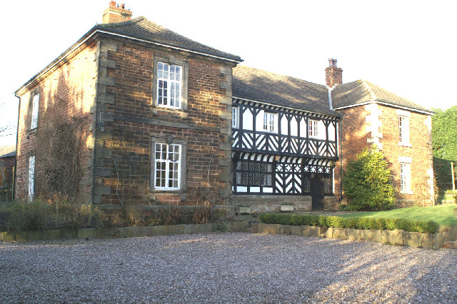
Heskin is a small village and civil parish of the Borough of Chorley in Lancashire, England. According to the United Kingdom Census 2001 it has a population of 883 increasing to 898 at the 2011 Census.This increased to 906 at the 2021 Census. Etymology The name ''Heskin'' is of Brittonic origin. As with Haskayne, the first element is ''hesg'' meaning "sedge" (c.f. Welsh ''hesg'', Gaelic ''seisg''). This is suffixed possibly with ''-īn'', an adjectival and toponymic suffix. Architecture Heskin Hall Heskin Hall dates back to 1548.Heskin Hall Antique Centre (2009) "Heskin Hall History", (Taken from the History Sheet published by the owners of the property) The last people to occupy the hall as a residential home were Lord Lilford and his fourth wife in the 1960s. Since then the hall has been used commercially for antique sales, and other uses including Blackburn College who have used it for training and educational purposes. The hall is now registered as a venue for weddings a ... [...More Info...] [...Related Items...] OR: [Wikipedia] [Google] [Baidu] |
Listed Buildings In Heskin
Heskin is a civil parish in the Borough of Chorley, Lancashire, England. It contains 17 buildings that are recorded in the National Heritage List for England as designated listed building In the United Kingdom, a listed building or listed structure is one that has been placed on one of the four statutory lists maintained by Historic England in England, Historic Environment Scotland in Scotland, in Wales, and the Northern Irel ...s. Of these, one is listed at Grade I, the highest of the three grades, one is at Grade II*, the middle grade, and the others are at Grade II, the lowest grade. The parish is almost completely rural, and most of the listed buildings are, or originated as, farmhouses and farm buildings. The other listed buildings are large houses and associated structures, and a cottage. Key Buildings References Citations Sources * * * * * * * * * * * * * * * * * * * * {{DEFAULTSORT:Heskin Lists of listed buildings in Lancashir ... [...More Info...] [...Related Items...] OR: [Wikipedia] [Google] [Baidu] |
Heskin Hall
Heskin Hall is a manor house in Heskin, Lancashire, England. Construction began on the present hall in 1545 making it a Tudor building which has been designated a Grade I listed building by Historic England. History In 1506 the lands were sold to Edmund Dudley who was Minister for king Henry VII. Dudley was executed by the king for treason and the land passed to his widow Elizabeth who later married Arthur Plantagenet. The land passed to John Dudley, 1st Duke of Northumberland, in 1511, who was later executed by Queen Mary, and his son Robert Dudley, 1st Earl of Leicester, was a favourite of Elizabeth I. In 1556 the estate was bought by Richard Molyneux who also bought lands from Mary Seymour, the widow of Thomas Seymour who was the father of Jane Seymour (wife of Henry the VIII). Following the death of Richard in 1568 the estate passed to his son William Molyneux. The house remained the home of the Molyneux family until 1739 when it became a seat of the Mawdesley family, ... [...More Info...] [...Related Items...] OR: [Wikipedia] [Google] [Baidu] |
Eccleston, Lancashire
Eccleston is a village and civil parish of the Borough of Chorley in Lancashire, England. It is beside the River Yarrow, and was formerly an agricultural and later a weaving settlement. History Its name came from the Celtic word ''"eglēs"'' meaning a church, and the Old English word ''"tūn"'' meaning a farmstead or settlement, i.e. a settlement by a Romano-British church. Evidence of the settlement dates back hundreds of years; St. Mary's Church dates back to the 14th century AD. The village was mentioned in the Domesday Book of 1086, the book ordered by William the Conqueror, to detail all settlements and farms in England for the purpose of tax collection. Ingrave Farm, located on the northern side of the River Yarrow, is built on a moated site of an earlier building thought to date from the medieval period. The partly waterlogged moat about is wide and deep in places. About to the west is a smaller site about square, the moat of which has since been infilled. It was ... [...More Info...] [...Related Items...] OR: [Wikipedia] [Google] [Baidu] |
Chorley (borough)
The Borough of Chorley is a local government district with borough status in Lancashire, England. The population of the Borough at the 2011 census was 107,155. It is named after its largest settlement, the town of Chorley. History The non-metropolitan district of Chorley was formed on 1 April 1974, covering the area of four former districts, which were abolished at the same time: * Adlington Urban District * Chorley Municipal Borough *Chorley Rural District *Withnell Urban District The new district was named Chorley, and the borough status previously held by the town was passed to the new district on the day that it came into being, allowing the chairman of the council to take the title of mayor. Council Elections are generally held three years out of every four, with a third of the council elected each time. In the fourth year where there are no borough council elections, elections for Lancashire County Council as the higher tier authority for the area are held instead. Cho ... [...More Info...] [...Related Items...] OR: [Wikipedia] [Google] [Baidu] |
Borough Of Chorley
The Borough of Chorley is a local government district with borough status in Lancashire, England. The population of the Borough at the 2011 census was 107,155. It is named after its largest settlement, the town of Chorley. History The non-metropolitan district of Chorley was formed on 1 April 1974, covering the area of four former districts, which were abolished at the same time: * Adlington Urban District * Chorley Municipal Borough *Chorley Rural District *Withnell Urban District The new district was named Chorley, and the borough status previously held by the town was passed to the new district on the day that it came into being, allowing the chairman of the council to take the title of mayor. Council Elections are generally held three years out of every four, with a third of the council elected each time. In the fourth year where there are no borough council elections, elections for Lancashire County Council as the higher tier authority for the area are held instead. Cho ... [...More Info...] [...Related Items...] OR: [Wikipedia] [Google] [Baidu] |
George Powys, 7th Baron Lilford
George Vernon Powys, 7th Baron Lilford (8 January 1931 – 3 January 2005), was the son of Robert Horace Powys and Vera Grace Bryant. Born in 1931, he inherited the title of Baron Lilford in 1949 following the death of Stephen Powys, 6th Baron Lilford (his second cousin twice removed), until his death on 3 January 2005 at Paarl, South Africa. Personal life His father died in 1940 so at the age of eighteen years he inherited the title of Lord Lilford from his second cousin twice removed, Stephen Powys. He was educated at Stonyhurst College and lived at Saint John, Jersey, Channel Islands, following the divorce from his fourth wife. His first wife was Eve Bird whom he married in 1954. He moved to South Africa and married Anuta Merritt on 29 June 1957, but were divorced by September 1958. He set up a business in South Africa by where he manufactured car tyres. He married third wife Norma Yyvonne Shell on 12 September 1958, but were divorced in 1961. His fourth wife was Muriel S ... [...More Info...] [...Related Items...] OR: [Wikipedia] [Google] [Baidu] |
Mawdesley
Mawdesley is a village and civil parish in Lancashire, England, which had a population of 1,702 at the 2011 Census. History The name Mawdesley is thought to have originated in the reign of Edward I (1272–1308). The suffix -''ley'' describes a field, meadow or clearing. Records show that a manor existed in 1250 AD on the site of the present Mawdesley Hall. Mawdesley Hall is a small hall on a back road leading into the village. It was built by William Mawdesley in 1625, but altered towards the end of the 18th century. Transport The village is isolated from public transport services. No main roads pass through the enclave. An infrequent day time bus service runs from the centre of the village to Chorley and Southport. The nearest railway station is three miles away at Rufford. The local roads are minor back lanes, mostly narrow, unlit, lacking pavements, poorly maintained and generally unsuitable for the high volume of large 4x4 commuter vehicles and heavy farm traffic t ... [...More Info...] [...Related Items...] OR: [Wikipedia] [Google] [Baidu] |
Bob Gregson
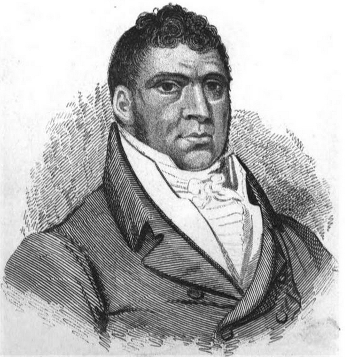
Bob Gregson (21 July 1778–November 1824) billed as "The Lancashire Giant" was a bare-knuckle fighter of the early 19th-century. He was a boxing champion, ferry captain and the owner of a chophouse in Holborn in London. A bust of Gregson is located in the Royal Academy. Henry Downes Miles, ''Pugilistica; The History of British Boxing'', John Grant, Edinburgh (1906) - pgs 237-241 Bor ... [...More Info...] [...Related Items...] OR: [Wikipedia] [Google] [Baidu] |
Bispham Green
Bispham Green is a village in the West Lancashire district of Lancashire, England. It is south of Mawdesley and less than north of Parbold. The civil parish of Bispham is the only one in the West Lancashire district that is served by a parish meeting instead of a town or parish council. At the 2011 census the parish had a population of 238. The surrounding areas was once popular for osier (willow growing) for the basket weaving trade, but since the 1950s the land has reverted solely to agricultural use. There are no industrial buildings and no future planning for any extensive development. Geography Bispham is south of Croston, Mawdesley and Tarleton, north of Hilldale and Parbold, west of Heskin, Wrightington and Eccleston. The River Douglas travels through Bispham and it is a tributary to the River Ribble and has two tributaries itself, the River Tawd and the River Yarrow. It shares its local parish with Mawdesley as Bispham has no actual churches on its land. ... [...More Info...] [...Related Items...] OR: [Wikipedia] [Google] [Baidu] |
Haskayne
Haskayne is a small village in the county of Lancashire, England, and on the West Lancashire Coastal Plain. It is to the north of Downholland Cross Downholland Cross is a small village in the civil parish of Downholland in the county of Lancashire on the West Lancashire Coastal Plain in England. It is to the north of Lydiate on the A5147 and the Leeds and Liverpool Canal The Leeds and ... on the A5147 road, A5147 and the Leeds and Liverpool Canal. The village is in Downholland civil parish, and forms part of the Aughton, Lancashire, Aughton & Downholland wards of the United Kingdom, ward, which is represented by three Conservative Party (UK), Conservative Party councillors and is part of the non-metropolitan district, district of West Lancashire. Etymology The name ''Haskayne'' is of Common Brittonic, Brittonic origin. The first element is ''hesg'', meaning "sedge" (Welsh language, Welsh ''hesg'', Breton language, Breton ''hesk'', Irish language, Irish ''seisc''; see ... [...More Info...] [...Related Items...] OR: [Wikipedia] [Google] [Baidu] |
2021 United Kingdom Census
The decennial 2021 censuses of England and Wales and of Northern Ireland took place on 21 March 2021, and the census of Scotland took place on 20 March 2022. The censuses were administered by the Office for National Statistics (ONS) in England and Wales, by the Northern Ireland Statistics and Research Agency (NISRA) in Northern Ireland, and by the National Records of Scotland in Scotland. These were the first British censuses for which most of the data was gathered online, and two of them went ahead despite the COVID-19 pandemic, in part because the information obtained will assist government and public understanding of the pandemic's impact. Enumeration in Scotland was postponed, and took place in 2022, the plans for it having been delayed because of the pandemic. The censuses in 2021 and 2022 follows on from Beyond 2011, a project by the UK Statistics Authority to assess the value, cost, and alternatives to a census in 2021. The project recommended a census in 2021, and amongst ... [...More Info...] [...Related Items...] OR: [Wikipedia] [Google] [Baidu] |
Croston
Croston is a village and civil parish near Chorley in Lancashire, England. The River Yarrow flows through the village. The population of the civil parish taken at the 2011 census was 2,917. History Croston was founded in the 7th century when St Aidan arrived at the riverside settlements. In the absence of a church, a cross was erected as a place of worship. The name is derived from the two Old English words 'cross' and 'tūn' (town/homestead/village) and is unique to the village. The parish of Croston was formerly far larger than it is today. It included Chorley, Much Hoole, Rufford, Bretherton, Mawdesley, Tarleton, Hesketh Bank, Bispham, Walmer Bridge and Ulnes Walton. These became independent parishes as a result of a series of separations between 1642 and 1821. A charter granted by Edward I in 1283 permitted an annual medieval fair and market to be held on the village green. Pre-20th Century maps also depict a castle which is believed to have been of a wooden constructio ... [...More Info...] [...Related Items...] OR: [Wikipedia] [Google] [Baidu] |


